Ausee (Luftenberg on the Danube)
| Ausee Hohenlohe, Luftenberg | ||
|---|---|---|

|
||
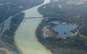
| Ausee on the right on the part of the community of Luftenberg an der Donau located south of the Danube , downstream of the Danube is the Abzüge-Asten power plant and to the left of the Danube is the northern part of the community of Luftenberg with an oxbow river of the Danube and the B3 (Donau Straße) | ||
| Geographical location | Luftenberg on the Danube , Upper Austria | |
| Tributaries | Groundwater | |
| Drain | underground | |
| Location close to the shore | Linz | |
| Data | ||
| Coordinates | 48 ° 14 '52 " N , 14 ° 25' 0" E | |
|
|
||
| Altitude above sea level | 240 m above sea level A. | |
| surface | 23 hectares | |
| Maximum depth | 6-10 m | |
|
particularities |
Water ski lift |
|
The Ausee Hohenlohe, Luftenberg, is a groundwater- fed, gravel mining , around 23 hectare large and up to ten meter deep quarry pond in the part of the municipality of Luftenberg an der Donau in the district of Perg in the Mühlviertel south of the Danube .
description
The Ausee area borders the north-eastern Traunviertel and is privately owned. It can only be reached from Luftenberg on foot or by single-track vehicles via the Abzüge-Asten power station . General access is from the south via Asten .
The area, located just a few kilometers southeast of the provincial capital Linz , serves as a local recreation area . In addition to the beach and dining facilities, there is a water ski lift , diving tower and a camping village for long-term campers right on the lake .
The Ausee lies at the intersection of the Danube Cycle Path (R1) and the Traun Cycle Path (R4). While the Traun Cycle Path ends here, the Danube Cycle Path can be continued via the Abzüge-Asten power station both north and south of the Danube.
The Ausee is integrated into the local hiking and cycling network of the communities of St. Georgen an der Gusen , Langenstein and Luftenberg an der Donau with the 10.2 kilometer long, almost entirely paved Auseeweg .
The physical, geographical and hydrological characteristics of the swimming lake are described as follows:
As a groundwater lake without permanent surface inflows and outflows, the bathing lake is not part of a surface water body and is located in the Bavarian-Austrian Alpine Foreland bioregion and thus part of the central low mountain range ecoregion .
- Bathing beach with grassy semi-natural land zone with sand, gravel and stones along the edge of the water around the entire lake with the exception of the area of the water ski lift.
- Waters with an average depth of three to five meters and a maximum depth of ten meters.
- Infrastructure consisting of showers and toilets with sewer connection and waste disposal system
- There is a ban on dogs and other pets on the area.
- The maximum number of visitors is around 1000 to 1500 people. The water is also used for fishing.
- The hydrological catchment area of the lake, located in the lowlands at around 235 meters above sea level, is one square kilometer. The altitude at the highest point of the catchment area is 253 meters, the lowest point is at 241 meters.
- The air temperature in the catchment area is 8 to 10 degrees Celsius on an annual average.
- The water temperature in the bathing season (June to August) between 2000 and 2009 was around an average of 22.8 degrees Celsius, with a maximum of 28.0 degrees Celsius and a minimum of 17.0 degrees Celsius.
history
The ancestors of the current owners had acquired what is now the contiguous area with the floodplain forest, which is flooded several times each year, from the mostly rural landowners in 1891 over the course of several years. During the construction of the Danube power plant from 1976 to 1979, part of it was lost due to expropriation, but the area was otherwise economically usable, whereby gravel and gravel were initially removed and the bathing lake was created from 1978. In 1988 a bridge was built over the so-called Mitterwasser, as the Ausee area is actually an island.
The water ski lift was opened in 1978. In 2013, the lift system was expanded to include an additional 2-mast lift. In 1980 the restaurant and two kiosks followed and in 1983 the camping village with the appropriate infrastructure. In 1995 a small chapel was built, which also has a bell. In 2002, after many flood-free years, the area was affected by the flood of the century . In 2017, a campsite for vacationers with 16 plots and infrastructure was built.
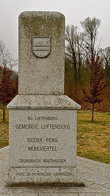
The Drei-Bezirke-Stein is remarkable at the point where the districts Linz-Land , Perg and the city of Linz meet.
fauna
Several species of fish and at least one cormorant can be found in the lake .
Web links
Individual evidence
- ↑ a b Hydrographically part of the Mitterwasser catchment area according to HZB or Ipfbach according to Wasserbuch (information according to DORIS: Layer waters and detailed catchment areas , status 2018) due to the Danube bank development
- ↑ Bathing water profile (PDF; 1.2 MB) requested on December 3, 2011.
- ↑ Andreas: History. Retrieved on June 4, 2018 (German).

