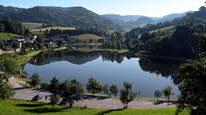
Waldhausen swimming lake
| Waldhausen swimming lake | ||
|---|---|---|

|
||
| Waldhausen swimming lake in Strudengau | ||
| Geographical location | Waldhausen im Strudengau , Upper Austria | |
| Tributaries | Sarmingbach, Sagauerbach | |
| Drain | Sarmingbach | |
| Places on the shore | Waldhausen im Strudengau | |
| Location close to the shore | Perg | |
| Data | ||
| Coordinates | 48 ° 16 '58 " N , 14 ° 57' 23" E | |
|
|
||
| Altitude above sea level | 470 m above sea level A. | |
| surface | 3.5 to 4.5 ha | |
| Maximum depth | 4 m | |
|
particularities |
Leisure area with beach volleyball court and children's playground |
|
The Waldhausen swimming lake is located in the market town of Waldhausen im Strudengau in the Perg district in Upper Austria .
description
The at 470 m above sea level. A. lying bathing lake is a reservoir that is formed in Waldhausen from the confluence of the Sarmingbach and Sagauerbach. The overwater flows over the Sarmingbach towards the Danube .
The lake is around 35 to 45 thousand square meters in size, a maximum of four meters deep and reaches temperatures of up to 26 degrees Celsius in summer. The brown color of the water is due to the naturally contained humic substances in the incoming water . In 2011 the water was of good quality with low bacteriological pollution.
The physical, geographical and hydrological characteristics of the swimming lake are described as follows:
As a dammed bathing pond, the bathing lake is part of a surface water body of the order of 10 to 100 square kilometers and is located in the granite-gneiss bioregion of the Bohemian Massif Alpine Foreland and is therefore part of the central low mountain range ecoregion .
- Bathing beach with grassy semi-natural land zone with sand and gravel along a four hundred meter long part of the water's edge.
- Waters with an average depth of one to two meters and a maximum depth of three meters.
- Infrastructure consisting of showers and toilets with sewer connection
- There is a ban on dogs and other pets on the area.
- The maximum number of visitors is around five hundred people. The water is also used for fishing.
- The hydrological catchment area of the lake, located in the flatlands at around 471 meters above sea level, is 41.74 square kilometers with parts in Upper and Lower Austria. The highest point in the catchment area is 1004 meters and the lowest point is 463 meters.
- The air temperature in the catchment area is 6 to 8 degrees Celsius on an annual average.
- In the bathing season (June to August) from 2000 to 2009, the water temperature was around an average of 20.8 degrees Celsius, with a maximum of 26.9 degrees Celsius and a minimum of 11.0 degrees Celsius.
At the lake there is a leisure area consisting of a sunbathing lawn planted with trees, a beach volleyball court , jetty, springboard and children's playground with slide and sand boxes.
Web links
Individual evidence
- ↑ Upper Austria Waldhausen Badesee ( page no longer available , search in web archives ) Info: The link was automatically marked as defective. Please check the link according to the instructions and then remove this notice. queried on December 3, 2011
- ↑ Bathing water profile (PDF; 1.3 MB) requested on December 3, 2011
