
Franziszeischer Cadastre
The Franziszeische Kataster , also Franciszäischer Cadaster , is the first complete Austrian real estate cadastre . It contains the properties of the territory of the Austrian Empire . Common names are also basic cadastre , tax registers and property tax register . He was born in the 1810er- to 1870s and is named after the first Austrian Emperor I Franz named.
The Franziszeische cadastre is something different than the Franziszeische (2nd) land survey, which was roughly at the same time : The cadastre had the aim of creating a uniform basis for the assessment of property tax , the land register primarily served military purposes ( military geography ).
The register is the now existing more than 200 years based on the land registry of Austria - the predecessor of the land database and the digital cadastral and other Vermessungsbehelfe in successor states of the Habsburg monarchy. As a result, until the second half of the 20th century, states whose territory only partially belonged to the monarchy only had detailed land registers in these parts and not in other parts. This was the case, for example, in Romania , where only Transylvania and Bukovina were part of the monarchy. In Italy there will still be two different land register systems (and thus procedures for purchasing land) in 2020, because only in the provinces of Bozen , Trient , Gorizia and Trieste and in a part of the province of Udine to the north of Strassoldo near Cervignano del Friuli the old Austrian cadastral and land register Land register system exists and is used.
Basics

The cadastre was created from 1817 to 1861 and is named after Emperor Franz I , who initiated the cadastral survey through the property tax patent dated December 23, 1817. The surveying work initially extended to the Austrian states of the monarchy ( Cisleithanien ). 300,082 km² were shown on hand-drawn, colored sheets of 20 × 25 inches ≈ 53 × 66 cm. One sheet includes 500 yokes . A total of around 50 million plots of land in around 30,000 cadastral communities were drawn up on 164,357 folders. The national territory of Austria is contained on 53,212 sheets.
The sheets of the cadastre are drawn on a scale of one Austrian inch to 40 fathoms , thus in a ratio of 1: 2880. The starting point for this scale was the then common Austrian military scale of 1 inch to 1000 steps (1: 28,800). The cadastral sheets were therefore usually drawn “ten times the military size”. Local areas were shown in 1: 1440, exceptionally also 1: 720, mountain areas in 1: 5760.
Lengths are given in inches and fathoms, areas in square fathoms, sometimes in yokes. One square inch in the portfolio corresponded to one yoke in nature. After 1870, the cadastral records began to include scales for the metric system and add them to older sheets. The cadastre includes the cadastral operation: These working documents document land, owner, house and real estate registers, land ownership sheets, cultural area permits, vineyard overviews and name directories.
The Hungarian countries ( Transleithanien : Hungary , Transylvania , Croatia , etc.) were recorded from 1850 and no longer by colored sheets. The survey area of the entire Austro-Hungarian monarchy covered 670,000 km².

Predecessors of the Franziszeischen cadastre are the tax levies under Maria Theresa and the Josephine situation book of Joseph II. From 1785–1789, which was based on the tax and land registry patent Josef II. This cadastre had to be repealed as early as 1790 and was used as a provisional property tax until the Franciscan cadastre.
The basis of the cadastre is the Franziszeische cadastral survey. The preparatory work for this started in 1806. The formal basis is the property tax patent dated December 23, 1817. This law put the taxation of properties on a new basis. The tax systems of Maria Theresa and Joseph II had used the property holdings of the respective landlords as a tax base; with the new land register, the income that could be generated from the land should be used for all landowners in the same way as the basis for state property taxes. The designation of the Franziszeischen cadastre as a "stable cadastre" is derived from this: The tax burden should be independent of the actual yield and thus the hard work of the owner, but also of the weather. Higher income through higher stakes should not lead to higher property taxes. Starting from the smallest unit, the parcel, all tax communities ( cadastral communities ), the federal states and finally the entire realm should be recorded.
The Franziszeische Cadastre is something different from the Franziszeische Landesaufnahme : The cadastre was the basis for tax collection and recorded the individual property, the Landesaufnahme had the task of recording the geographic situation mainly for military purposes.
Measurement process
The plots of each cadastral community were recorded at the beginning with measuring table recordings. These surveys were carried out by the military. In the course of further work, the technically current procedures were used. The areas of today's Austria were recorded in the following periods:
- Vienna and Lower Austria 1817 to 1824
- Upper Austria and Salzburg 1823 to 1830
- Styria 1820 to 1825
- Carinthia 1822 to 1828
- Burgenland (then German West Hungary) 1853 to 1858
- Tyrol and Vorarlberg 1855 to 1861.
Since there was no form of triangulation at the beginning of the survey that could have been used when determining the surveying bases, several local coordinate systems were created. For the Austrian territory there were coordinate origins
- for Vienna and Lower Austria the tower of St. Stephen's Cathedral in Vienna
- for Upper Austria and Salzburg, as well as the Gusterberg near Kremsmünster for Bohemia
- for Styria the Schöckl near Graz
- for Carinthia (as well as the Carniola and the coastal region ) the Krimberg near Laibach
- for Tyrol and Vorarlberg the southern tower of the parish church in Innsbruck
- for Burgenland, which belongs to Hungary, the eastern tower of the Budapest observatory

First of all, the boundaries of the municipality were determined and recorded in a boundary sketch. Within the municipality, the landowners had to mark the property boundaries with stones, pegs, hotter piles (mounds of earth) or pits (pegs). The boundaries between different land uses (cultivation types: meadows, fields, vineyards, etc.) were to be designated by the landowner. On this basis, the surveyor (survey adjunct) had to record the boundaries. In the case of cultural boundaries within a property, the surveyors were allowed to make adjustments, as long as the shape and area of the property remained essentially the same, and the delimitations of the cultural genres could be simplified (straight lines instead of curves, etc.). In some cases, less emphasis was placed on the precise presentation of tax-free and low-tax areas; small stables and other buildings of minor importance were not always recorded.
The information determined in the course of staking (including the owner) was recorded in a "field sketch". The measurement table picture specified their information more precisely, further details were recorded in the "indication sketch". The final sheet was created from these documents in the winter, when no outdoor work was sensible. The property numbers were only assigned after a further inspection by a commission (reambulation).
The survey was based on a series of service instructions, for example the 1824 cadastral surveying instruction (KVI). The surveyors were thoroughly checked (double virgulation). They had to finance their work equipment themselves and were liable for mistakes. The cadastral registry law replaced the previous rules in 1883 and stipulated that the state of the cadastre had to be checked every three years.

Initially, building plots were numbered separately with black numbers, the other plots were given red numbers. In 1865, uniform numbering of all properties was ordered; from 1912 both property types were to be numbered in black letters. Building plots were given a point in front of the number to distinguish them . These "building plots with a point" can also be found in land registers in the 21st century. They can cause misunderstandings: The numbers “ . 21 "and" 21 "in a cadastral parish designate different plots of land that can be far apart (the 21st undeveloped plot of land does not have to be near the 21st building area of a municipality; the existence of a plot of land with a dot does not mean that it is there must be a plot of land without a point).
The result of the recording was a group of sheets that were collected in a folder, including the auxiliary notes, sketches and lists made: the master folder with the cadastral operat. On the outside of the dust jacket of the original folder there is a simplified sketch of the contents ( called “Kroki” in everyday life , from French crocquis, sketch).
The cadastral records of the areas outside the Austrian state borders were handed over to the successor states after the dissolution of the monarchy: These holdings are in archives in Italy , Slovenia , Hungary , Slovakia , the Czech Republic , Poland , Croatia , Romania and the Ukraine .
Original folder
The “Urmappe” (original folder) forms the core of the cadastre: It contains the original, hand-colored drawings for a cadastral community in a cardboard protective cover. The surveyors are named at the bottom. Smaller cadastral municipalities can be combined with a neighboring municipality in one folder. There is one sheet per folder that provides more detailed information on the location and administrative affiliation of the cadastral municipality in decorative writing and contains the year of production as well as the original, sometimes also a metric scale specification (title page). This sheet is not always sheet I of the portfolio.

Folder for two cadastral communities: Kloster Kloster , Rettenbach cadastral communities and Klosterwinkel

Community of Freiland , cadastral community of Mitterspiel, with a handwritten addendum to change the area
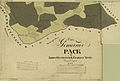
Parish Pack , district Packwinkel, with flap on the top right, scale 1: 5760

Municipality of Mahrenberg im Drautal , Lower Styria , added scale on a metric scale

Municipality of Oberpreitenegg with the administrative structure 1828: Waldenstein district , Kingdom of Illyria


The master folder for the areas of Austria is kept in the Federal Office for Metrology and Surveying (Cadastral Map Archive ) in Vienna . It is a cultural asset according to the Hague Convention , can only be viewed under supervision and with gloves. Yellow spots on the back of the original folder sheets are not soiling, but residues of the mandatory procedure of sticking the drawing paper with egg white over the entire surface of the drawing base.
A number of other documents are based on the original folder:
As a rule, a duplicate (duplicate folder) was made from the original folder within a few months. These duplicates are in the archives of the Austrian federal states. Even these copies are not always congruent with the original folder. They differ not only in the representation of the sheet numbers (usually in the middle of the sheet instead of at the top), but also in the sheet cut: About a third of all sheets in the original folder have attached attachments, so-called "flaps". To avoid such flaps, the areas of the original folder are often shown differently in the copies. Since the cadastral copies were easier to access in the federal states, changes were added more quickly (or taken into account in new editions) than in the original folder, where changes are sometimes only mentioned by handwritten notes.
In addition, "rectification versions" were made, which reflect the state of the cadastre in later years. Like the sheets of the Hungarian regions, these versions are no longer fully colored. There are a number of other worksheets and - from cities - compilations of several, possibly extended, cadastral sheets as custom-made products. There are also prints ( lithographs ) of cadastral sheets, for the preparation of which there were worksheets (see picture Seeland, Seebergsattel). These sheets do not have to contain all the details of the original folder and in some cases do not have the property numbering.

Most of the Austrian part of the original folder has been digitized. At the end of 2008, the Federal Office for Metrology and Surveying is planning to have all the sheets in the original folder fully digitally recorded. A file size of 20 to 30 megabytes per sheet is to be expected (resolution 300 dpi ). The image files linked in this article and on the Internet are edited, technically partially heavily emaciated versions that do not have the technical quality of the original files.
Some of the duplicate folders in the regional archives can also be scanned, for example the maps of the folder copy (referred to as the “original folder”) from Upper Austria . Slovenia has made the copies of its portfolio available on the Internet.
Accuracy and commitment
The main focus of the information in the cadastre lies in the valuation of properties: all properties are shown, even if they were unproductive (wasted), as well as information on the construction of houses: wooden houses are yellow, stone houses are pink, public buildings (churches, offices, etc. .) dyed red. Pastureland is divided into communal pasture (GW) and pasture (W) and is colored pale green. Meadows are kept in a stronger shade of green. Fields are light brown, vineyards pink. In addition to the color, the cultures are indicated by small symbols (vines, chestnut trees, etc.).
Forests are colored gray, a distinction is made between coniferous and deciduous forests, but also according to age (JM Jungmais, SH Stangenholz, MH Mittelholz, HS high-stemmed wood, etc.).

Updating the cadastre already encountered great difficulties in the 19th century: There was no guarantee that changes in the property portfolio would actually be passed on to the cadastral authorities; apart from that, constant updating of the sheets was almost impossible due to the low staffing level. In addition, when separating areas that were measured more precisely according to later rules, previously existing errors increasingly affected the remaining plot of land (problem of remaining space): A plot of (according to the cadastre) 1000 m², which is actually only 980 m² (2% error) has cut off exactly measured 500 m², 480 m² remain as the "remaining area" (4%, thus double error). If the completeness of this remaining area is decisive for the existence of a right (e.g. private hunting right , 200 yoke = 115 ha), this can lead to the loss of this right. The courts have repeatedly denied the cadastral authorities' liability for such errors. This with reference to the fact that the aim of the cadastre is not the binding area representation.
The cadastral sheets are not a substitute for maps : traffic connections and streams are usually only recorded if the path plot or the creek bed form their own plots of land. In the original map, this is only the case for state roads ( Chausseen ) and other important connecting routes; in later editions of the cadastre, more emphasis was placed on the representation of these connections (see, for example, the changes marked in red in the picture on the right around the church of St. . Oswald and around the Stephlbauer farm). Changes in the municipal boundaries are noted by hand in the original folder.
The cadastre does not contain any information on the altitude such as fixed points , contour lines , hatching or hillshading, and no information on the inclination of the base.

Investigations in open terrain indicated an average error of 80 cm, and more in unfavorable terrain. The average line width of 0.15 mm alone results in a maximum accuracy of around 40 cm at the usual 1: 2880 scale. Despite careful storage, changes (shrinking, warping) in the ( hand-scooped ) paper of the cadastral sheets are to be expected. The representation in the cadastre can therefore show deviations in the range of meters for length information and up to 20 percent for area information.
For a reliable statement about the state of the cadastre at a certain point in time, it may be necessary to refer to the original folder, any subsequent (rectification) versions thereof, the work records of the surveyors and the copies of the respective state archives. If the boundaries and areas of a property have not been measured using more modern methods since it was recorded in the Franziszeische Cadastre, information from the beginning of the 19th century can still be found in the land registers and land register extracts of the 21st century. In Austria, half of all properties are said to have never been measured since they were entered in the land registry.
The boundaries and areas shown in the Franziszeisches Cadastre are not legally binding. The size of plots can have changed due to changes in the terrain (relocation of paths, soil erosion and landfall ) and due to the acquisition of parts of the property. The information in the cadastre can be checked by remeasuring in accordance with the rules of the Surveying Act ( border cadastre and digital cadastral map ).
See also
- List of map series
- Franzisco-Josephinische Landaufnahme
- Franziszeische Landesaufnahme
- Valid (tax)
- Josephine land survey
Original sources and access to the Franziszeischen Cadastre

The original folder for the areas of Austria is kept in the cadastral archive at the Federal Office for Metrology and Surveying . The other sheets were handed over to the successor states. The originals of the Franziszeische Landesaufnahme, 2,628 map sheets and derived maps are accessible in the Austrian State Archives / War Archives .
Digitization online:
Regional:
- Cadastral sheets of the copy of the duplicate folder of the State of Upper Austria (map layer at DORIS intermap)
- Cadastral sheets of the copy of the original folder from 1857 for the state of Vorarlberg (map layer at VOGIS)
- Cadastral sheets from the area of Slovenia (at that time Lower Styria , Carniola and parts of Carinthia , Görz , Rijeka , Trieste , Istria , Übermur and the Austrian coastal region )
- Cadastral sheets for Bohemia, Moravia and Austrian Silesia of the Český úřad zeměměřický a katastrální
literature
- Susanne Fuhrmann: Digital historical geographic base data in the Federal Office for Metrology and Surveying (BEV). The original folder of the Franziszeischen cadastre. In: Austrian Journal for Surveying and Geoinformation. Published by the Austrian Society for Surveying and Geoinformation (OVG). ISSN 0029-9650 . 95th year. Issue 1/2007. P. 24–35 ( article pdf , vorarlberg.at) - with a detailed description of the procedure.
- Ernst Hofstätter: Contributions to the history of the Austrian regional recordings. An overview of the topographical recording procedures, their origins, their developments and organizational forms of the four Austrian regional surveys. 2 volumes. Federal Office for Metrology and Surveying , Vienna 1989.
- Heinz König: The successful discovery of the original property tax patent: A king finds the emperor's signature. In: 200 Years of Cadastre: Austrian Cultural Property 1817-2017 . Vienna 2017, pp. 53–70.
- Michaela Schlögl : A digital image of Kakania. The Franziszeische Cadastre - the overall representation of the K. u. k. 19th century monarchy - is now captured using modern methods. In: Die Presse of March 19, 2008 ( online, Presse.com → Tech & Science ).
- Werner Drobesch (Hrsg.): Carinthia at the transition from the agricultural to the industrial society. Case studies on the situation and performance of agriculture on the basis of data from the Franziszeischen cadastre (1823–1844) (= From Research and Art 40/1, Verlag des Geschichtsverein für Kärnten, Klagenfurt 2013).
Special
- Rainer Feucht: Area information in the Austrian cadastre. Diploma thesis at the Institute for Geoinformation and Cartography of the Vienna University of Technology, March 2008 ( pdf, geoinfo.tuwien.ac.at )
- Roland Bäck: The "Franziszeische Cadastre" (1817–1861) as a source of economic, social and environmental history in the initial phase of the "Industrial Revolution". Digital consolidation of archive material completed in the Carinthian regional archive as part of the FWF project “Franziszeischer Kataster”. Carinthia I 199 (2009), pp. 363-368.
- Werner Drobesch: Soil registration and assessment as part of a state modernization. Theresian Tax Rectification, Josephine Cadastre and Franziszeischer Cadastre. In: Reto Furter, Anne-Lise Head-König, Luigi Lorenzetti (Red.): Les migrations de retour. Return migrations (= Histoire des Alpes - Storia delle Alpi - History of the Alps 14/2009), pp. 165–184.
Regional
- Walter Liebhart, Roland Bäck: The Klagenfurt Basin as an economic and settlement area in the 19th century. Distribution of cultural areas, land and water use with special consideration of the "Franziszeische cadastre" (1817–1861). Carinthia I 199 (2009), 369-394.
- Kurt Scharr : The Franziszeische cadastral map record in the Bukowina. Their importance for the development of the country and as a historical source . With a summary in Ukrainian. In: M. Dippelreiter, S. Osatschuk (Ed.): Chernivtsi in the context of urban processes in East Central Europe from the 18th to the 20th century. Contributions from the international scientific conference on the occasion of the 600th anniversary of the first documentary mention of Chernivtsi on June 6-7. May 2008, bilingual conference proceedings, Чернівці / Tscherniwzi / Chernivtsi 2009. pp. 54–68.
- Hannes Obermair , Alessandro Campaner (edit.): The cadastral maps of South Tyrol - the Franziszeische national survey . Bolzano: South Tyrolean Provincial Archives 2001.
- Helmut Rumpler (with the collaboration of W. Drobesch, R. Bäck and Walter Liebhart) (Eds.): The Franziszeische Cadastre in Kronland Carinthia (1823–1844) (= From Research and Art 40/1, Verlag des Geschichtsverein für Kärnten, Klagenfurt am Wörthersee 2013). ISBN 978-3-85454-126-4 .
- Helmut Rumpler, Kurt Scharr, Constantin Ungureanu (with the collaboration of W. Liebhart, M. Kollegger, R. Bäck) (Eds.): The Franziszeische Cadastre in the Crown Land of Bukowina, Czernowitzer Kreis (1817–1865): Statistics and cadastral maps (= publications the Commission for Modern History of Austria 112, Böhlau-Verlag, Vienna-Cologne-Weimar 2015). ISBN 978-3-205-79698-5 .
- Werner Drobesch (Ed.), Carinthia at the transition from an agricultural to an industrial society. Case studies on the situation and performance of agriculture based on the data of the Franziszeischen cadastre (1823-1844) (= From research and art 40/1, Verlag des Geschichtsverein für Kärnten, Klagenfurt am Wörthersee 2013). ISBN 978-3-85454-126-4 .
bibliography
- Bibliography of the BEV on the cadastre (PDF file, approx. 80 kB)
Web links
- Information on the original folder in the Federal Office for Metrology and Surveying, Vienna.
- Address list of contact persons for the master folder in other countries (PDF file; 63 kB)
- Overview by country (links to maps online)
- Online view of the Franciscan Cadastre on Mapire.eu
Legend:
- Regulation for drawing the cadastral plans (image file on DORIS, doris.ooe.gv.at)
Regional:
- Cadastre in the state of Lower Austria (Lower Austrian Provincial Archives)
- Cadastre in the state of Upper Austria ( DORIS , layer Urmappe , various map topics , such as first regional recordings , Urmappe quality, especially the topic Urmappe or cultural atlas ); information
- Cadastre in the State of Salzburg (SAGIS)
- Cadastre in Carinthia ( KAGIS ), Layer: Map background | Franziszeischer Cadastre
- Historical cadastre in South Tyrol
- www.franziszeischerkataster.at - Scientific pilot project Carinthia and Bukowina as reflected in the Franziszeisch cadastre
- Links to maps in Croatia and Hungary (on mapire.eu)
- Links to maps in Moravia (by municipality)
- Historical cadastre in Bohemia and Moravia (search on the map of the Czech Republic or by municipalities)
Individual evidence
- ↑ Ulrike Christine Walter: Trustee for property acquisition in Italy. Registration of real estate. In: Nova & Varia. The quarterly of the Austrian Association of Lawyers. Published by the Association of Jurists , Vienna. Issue 1/2020, p. 29.
- ↑ a b Feucht, page 7.
- ↑ Figures from Fuhrmann, Geobasisdaten, page 24 and Schlögl, digital image. The 53.212 is published by Schlögl.
- ↑ A ratio of 26.340053333 millimeters to (40 x 1.896483840 m =) 75.8593536 meters, thus 1: 2880. Rounding differences are irrelevant in view of the line thicknesses, the unevenness of the paper and the margin of error of manual measurement.
- ↑ Feucht, page 7: An old Austrian mile of 7.585935360 km had 10,000 steps, 4000 fathoms and thus 288,000 inches. 1 fathom = 6 feet. 1 foot = 12 inches, hence: 1 inch on a "military measure" map = 1000 steps = 400 fathoms = 400 x 6 feet = 400 x 6 x 12 inches = 28,800 inches, which is a tenth of a mile in nature.
- ↑ a b Feucht, page 8.
- ↑ 1 inch in plan = 40 fathoms in nature. 40 x 40 = 1600. One yoke = 1,600 square fathoms.
- ^ Fuhrmann, page 24.
- ↑ also called versions, tax rectifications, Theresian version, Theresian cadastre or Theresian valid book.
- ↑ Josephinische Lagebuch, Josephinische Fassion or also Josephinischer Cadastre.
- ↑ Daily newspaper Oberösterreichische Nachrichten : “Wir Oberösterreicher”, April 12, 2008.
- ↑ Feucht, page 6.
- ↑ Brief description ( page no longer available , search in web archives ) Info: The link was automatically marked as defective. Please check the link according to the instructions and then remove this notice. (PDF file; 229 kB) from the Tyrolean Provincial Archives on the development of land registers in Austria. Records (situation books) of the Josephine cadastre are in the state archives of the countries of the monarchy at that time.
- ↑ Real estate tax patent 1817. Political laws and ordinances Franz I. 1792–1848. Volume 45 Vienna 1819 No. 162. Pages 391–398.
- ↑ a b Feucht, page 10.
- ↑ The Stable Cadastre in Styria. In: landesarchiv.steiermark.at. Retrieved July 16, 2017 .
- ↑ a b Fuhrmann, page 28.
- ↑ von virgeln : check very carefully even for small things. Jakob and Wilhelm Grimm: German Dictionary . Volume 26 Vesche-Vulkanisch. Leipzig 1951. Keyword “Virgeln”. Column 371, line 69. Reprint: Deutscher Taschenbuch Verlag, Munich 1991, ISBN 3-423-05945-1 . Structure quoted from: The digital Grimm - Electronic edition of the first processing. Version 12/04. Verlag Zweausendeins, Frankfurt am Main. Competence center for electronic cataloging and publication processes in the humanities at the University of Trier in conjunction with the Berlin-Brandenburg Academy of Sciences, ISBN 3-86150-628-9 .
- ↑ Fuhrmann, page 30.
- ↑ Fuhrmann, page 27.
- ↑ Law of May 23, 1883 on the keeping of records of the property tax cadastre. Austrian Reich Law Gazette No. 83/1883, pages 249–268.
- ↑ a b Fuhrmann, page 31.
- ↑ Digital Atlas Styria, digital cadastral map, z. B. cadastral community 61027 Klosterwinkel.
- ↑ Brief description of the cadastre of the Tyrolean State Archives, see above. Page 2.
- ↑ This is the young forest that grows back on a log . The word has nothing to do with the plant maize , it comes from meisz , a word for logging that was once widespread in the Bavarian-speaking area : Jakob und Wilhelm Grimm: German dictionary . Volume 12 L-Mythical. Leipzig 1885. Keyword “Meisz”. Column 1984, line 1. Reprint: Deutscher Taschenbuch Verlag, Munich 1991, ISBN 3-423-05945-1 .
- ↑ Feucht, page 58.
- ↑ Feucht, page 70.
- ^ Fuhrmann, page 26 with reference to Christoph Twaroch: The cadastre as evidence in border disputes. Austrian Journal for Measurement and Photogrammetry (ÖZfVuPh), 74th year 1986. Issue 3, pages 177–186.
- ^ Fuhrmann, pages 26-27.
- ↑ a b Resolution 76 / E XXIII. GP : Reference to the non-binding nature of the area information in electronic land register extracts, adopted at the meeting of the Austrian National Council on June 5, 2008 in the XXIII. Legislative period based on proposal 362 / UEA XXIII. GP. (PDF file; 69 kB)