
Monastery (municipality of Deutschlandsberg)
|
Monastery (former parish) locality  |
|||
|---|---|---|---|
|
|||
| Basic data | |||
| Pole. District , state | Deutschlandsberg (DL), Styria | ||
| Judicial district | Deutschlandsberg | ||
| Coordinates | 46 ° 53 '21 " N , 15 ° 6' 2" E | ||
| height | 1050 m above sea level A. | ||
| Residents of the village | 109 (January 1, 2020) | ||
| Building status | 148 (2001 ) | ||
| surface | 22.1 km² | ||
| Post Code | 8530 Deutschlandsberg | ||
| prefix | + 43/3469 (Sankt Oswald in Freiland) | ||
| Statistical identification | |||
| Community code | 60344 | ||
| Locality code | 14516 | ||
| Counting district / district | Monastery (60344 014) | ||
 Location of the former municipality in the Deutschlandsberg district |
|||
| Independent municipality until 2014 Since 2015 Germany Berg |
|||


Kloster is an area in the northwest of the city of Deutschlandsberg in western Styria . Until the end of 2014, Kloster was a municipality with 194 inhabitants (as of January 1, 2015) in the Deutschlandsberg district in Styria , Austria . In 2015, as part of the Styrian community structural reform , Kloster was merged with the communities Deutschlandsberg, Bad Gams , Freiland bei Deutschlandsberg , Osterwitz and Trahütten . The basis for this is the Styrian Municipal Structural Reform Act - StGsrG. A merger and development agreement with Deutschlandsberg and Bad Gams was signed on November 18, 2013.
geography
structure
Kloster is located in western Styria and consists of the village of Kloster and the two cadastral communities of Klosterwinkel and Rettenbach . The main town is St. Oswald in Freiland . This place is named after the patronage of the Roman Catholic parish church , the parish also bears this name.
The borders of Kloster are largely formed by three rivers: Rettenbach and Laßnitz in the south, Wildbach in the northeast. The border in the northwest runs from the ridge of the coral train to the Reinischkogel . In Rettenbach the Gratzenbach flow , in Klosterwinkel the Klosterbach and a number of other small streams.
The most important elevation is the Schwarzkogel at 1550 meters. The settlement areas (mainly farms) are located on its partly steep slopes. The Filzmoos is located on the Freiländer Alm . It is the area of origin of Rettenbach and Klosterbach. Kloster is located in the south of the Pack-Reinischkogel-Rosenkogel nature reserve.
Kloster was to be found in the official statistical documents under the municipality code number 60316: The area was 2,201.46 ha. The municipality of Kloster had altitude class 8. Its NUTS 3 code was AT225 for western and southern Styria.
The monastery forms a census cluster of official statistics and, according to the official statistical documents based on the 2001 census, has 148 buildings, 71 of which are where people have their main residence. In 2001, 233 people lived in 86 households and 157 apartments in Kloster. This year 65 secondary residences were counted in Kloster, 11 workplaces and 38 agricultural and forestry operations.
Enlargement of the former community in 1891
In 1891 the municipality of Kloster was expanded to include the area of "Ober Mitterspiel" in the east. This area originally belonged to the then community of Freiland near Deutschlandsberg (then called Mitterspiel). It was completely ascribed to the cadastral community of Klosterwinkel, although it partially connects to Rettenbach on the southern slope of the Schwarzkogelzug. The shape of the cadastral municipality of Klosterwinkel and ambiguities in linguistic usage regarding the extent of the Rettenbach area can be traced back to this change in area.
Area and population figures from the time the community was established around 1850 and up to 1891 refer to the then smaller community area.
- The change in the boundary between the communities of Kloster and Mitterspiel in 1891 in the official documents

Border of the municipality of Kloster, cadastral communities of Rettenbach and Klosterwinkel , to Mitterspiel before 1891 in the Franziszeischen cadastre

Ober Mitterspiel has been the southeastern part of the Kloster community since 1891

Registration of the change of area with the municipality of Freiland

Title page of the decree of the k. k. Ministry of Finance on the border change

Sketch of the boundary change in 1891


Gray = forest, green = meadow, scrub, W. = pasture, light yellow (in these leaves from 1825, the color is difficult to distinguish from the paper color) = alpine pasture or less productive, darker yellow = arable land, brown = parcel of paths. Yellow buildings = wooden buildings, red buildings = stone buildings. JM = young maize, MH = medium wood, SH = pole wood, HS = high-stemmed, felling forest. Supplements up to the second half of the 19th century are shown in red.
climate
The area lies in the lee of the Alps . Weather influences from the west, as they are predominant in the rest of Austria ( west wind zone ), also dominate in monastery, but are weaker. The Koralm, in which Kloster is located, is one of the areas with the highest average wind speeds and frequency of storms in Austria. In their area, influences from two climatic zones ( subtropics - moderate latitudes ) meet . The climate is influenced by the Mediterranean area . It is milder than in the northern regions of the same altitude in Austria and in comparison has longer periods of good weather ( sunshine duration ). Disturbance fronts, which bring heavy precipitation in westerly weather, often do not reach the area or only at a reduced rate.
Rain in summer usually falls in the form of thunderstorms or downpours / heavy rain, which pass quickly but can be very violent. When strong disturbance fronts pass through, short snow showers can be expected on the alpine pastures due to their altitude, even in midsummer. The sunshine phases cause clear, cloudless nights, in which it can be very cool even in summer. Since large parts of the monastery are located far away from settlements and the exposure to light sources is low, the conditions for observing astronomical objects can be good on such nights .

The Kloster area is one of the areas in Austria with the highest number of thunderstorm days per year (over 50 days with thunderstorms). Hail is relatively common. Earlier, when grain cultivation was more intensive, it caused significant damage to crops. The monastery is too high (900–1500 m above sea level ) to benefit from the favorable climatic conditions of western Styria. The climate of the area is called a relatively strong stimulating climate . The Koralm area and its eastern roof, in which the monastery is located, are separate climatic regions.
The climatic situation and altitude mean that the vegetation seasons in the area are shifted: in the lower parts (border to open land: farms Strasser, Kleinahansel, Klugbauer, Marxhansel, but also in the lower part of the Sterzriegel ) can be harvested earlier, in the upper parts only up to about two weeks later.
Plant occurrences in the area of St. Oswald were highlighted as rare alpine plants in the encyclopedia ofersch Gruber in 1836 . Apargia crocea Haerke (a type of dandelion), Swertia perennis L. ( swamp gentian ) and Juncus trifidus (three-leaf bulrush) are specifically mentioned .
Floors
The agriculturally usable (or previously used as such) soils are rocky brown soils made of crystalline slate as medium-quality arable and grassland with almost all types of water supply up to the pseudogley . Arable use only makes sense up to an altitude of 800 to 1000 m above sea level . Nutrient -poor tendrils are also common .
geology
The rocks belong to the Koralm crystalline: They are different forms of gneiss , partly flat (plate gneiss) and slate (mica schist). The summit of the Schwarzkogel is made of eclogite . Limestone and dolomite , which are otherwise common in the Austrian parts of the northern and southern Alps, are not found in Kloster. Individual marble deposits are embedded in the crystalline. Examples of the rocks are prepared in the Geopark Glashütten in Gressenberg , the geological specialist literature names a number of mineral deposits in the area, especially on the Hebalm , for garnet , hornblende , bronzite , apatite and quartz .
Neighboring places
|
Pack / Modriach |
Precious scrap | Marhof |
| Preitenegg |
.svg)
|
Bad Gams |
| Osterwitz | Osterwitz | Outdoors |
Culture and sights

- The Roman Catholic parish church of St. Oswald in Freiland was mentioned in a document in 1434. It is a listed building.
Former municipal coat of arms
Since 2004, the congregation of Kloster had the right to use a communal coat of arms. The heraldic description of the coat of arms reads:
- "A divided shield with damascened red and silver at the bottom, a natural raven in silver at the top with a red ring in its beak."
The depiction of the raven with a ring in the coat of arms can be traced back to the patron saint of the parish church St. Oswald in Freiland , St. Oswald of Northumbria . The red and silver rhombus on the lower half of the coat of arms is a quote from the coat of arms of the Admont Abbey and is intended to remind of the centuries-long association of the community with this monastery.
Names
The word "monastery" belongs to a group of Latin loanwords that were taken over from the usage of early Christianity and is based on the Latin "claudere (clausum)" for "(ver) close".
In the present context, the word designates an area that was assigned to the (Benedictine) monastery of Admont and that was located in the southwest of an area that was previously under this monastery and the Rein monastery near Graz, and was thus influenced by monasteries within and outside its borders . A monastery in the strict sense of the word did not exist in the area. The name was not taken over from a cadastral community, but arose with the creation of the former community. It also has nothing to do with the name of the parish and the parish of St. Oswald. It corresponded to the local name, but was unusual for the creation of community names. It was specifically pointed out in the community overview.
The official spelling for place and parish is " St. Oswald in Freiland " (deliberately in , not in ). The addition to the name distinguishes the place and the parish from a number of other places in the south-west of Styria, which also derive their name from a patronage of St. Oswald.
Population structure
According to the 2011 grid count, the municipality of Kloster had 192 inhabitants, 67.6% of the 1848 population.
| Population distribution 2011 | |||||
|---|---|---|---|---|---|
| Klosterwinkel (with St. Oswald) | 118 | ||||
| Rettenbach | 74 | ||||
Population development from 1848 to 2011

For 1939, the then so-called “permanent population” plus the residents of the Reich Labor Service camp, which were neither present before nor later, are reported.
history
Origin of the community
The municipality of Kloster was created in 1850 from the " numbering sections " or "conscription communities" Rettenbach and Klosterwinkel (sometimes just called "monastery") that had existed since 1770 . The basis for this was the administrative reform of the Austro-Hungarian monarchy after 1848 , the legal basis was the “Provisional Municipal Law”. At that time these districts had 129 and 155 inhabitants respectively.
Until this reform, the area had belonged to the manor of Freiland of the Admont Abbey ("Amt Freiland") since the 13th century . This manorial rule consisted of today's open land near Deutschlandsberg (then: Mitterspiel), Rettenbach and Klosterwinkel.
According to the quarter division of Styria in 1462, the municipality area was in the “quarter dieshalb der Piberalm”, which was also known as the “quarter between the Mur and the Drau”. In the 16th and 17th centuries , the jurisdiction of the courts lay outside of the eaves right , which at least belonged to the manorial rule, for the lower jurisdiction with the "Admontischen Burgfried Freiland" and thus also with the manor , for the higher (blood) jurisdiction with the regional court Ober- Wildon . In general contexts in which there were no exceptions in favor of the monastery, the authorities of the Marburg district of the Duchy of Styria were responsible. These authorities were based in Marburg an der Drau . From 1849 the area was in the Graz district .
The borders in the Rettenbachtal meant that a number of farms from the former neighboring municipality of Osterwitz , Osterwitz-Winkel district (including Pöschl, Kleinreinisch, Stoff and Stefflpeterkeusche / Pust) had shorter and better connections to the municipality of Kloster than to their own community center. In 1864 vlg. Pöschl asked unsuccessfully to move to the municipality of Kloster. The children of these Osterwitzer Höfe attended the school in St. Oswald (partly with, partly without the approval of the school authorities). Those who died from these farms were buried in the open land of St. Oswald's cemetery. The demarcation in the Wildbachtal led to a similar situation for some farms in the Sallegg cadastral community of Bad Gams , so that there are burial sites for families from Sallegg at the Kloster cemetery.
Traffic routes and Slavic settlement in the 6th and 7th centuries
The monastery is located on an old path from Deutschlandsberg over the Koralm to Carinthia (today Hebalmstrasse , Styrian state road 606). This connection was one of the eight known routes on the wine routes leading to Carinthia.

Another important route crossed the monastery east-west:

In 1225 a road from Gams is mentioned that went over the Greim area to the Alps - the "Greimstraße". The "Hube an der Abetz" was located on this street. This name was the name of the old, no longer existing farm in the Rettenbach valley at the beginning of the Hebalm (also called Nikljosl, approx. 500 m southeast of today's Hebalm inn Rehbockhütte). The historical maps of the area show several possibilities for the course of this road: It can run in the municipality of Kloster west of the Schwarzkogel over the Freiländer Alm over the Klosterwinkel or south over the area of Rettenbach.
The Slavic farm name of each farm "Gratzen" in the districts of Rettenbach and Klosterwinkel are an indication that the municipality belonged to the Slavic principality of Carantania in the 6th and 7th centuries . At the same time, these names are evidence that the streets of the municipality were of supra-local importance and were at least subject to a certain official observation.
The monastery area was on the south-eastern border of Austrasia and eastern France . References to this have not been preserved, but can play a role in the evaluation of place names and personal names.
In Carantania, the monastery was located in the middle of a large area inhabited by the Slavic population. After its disintegration from the 9th century and the foundation of the Mark an der Mur , it came to its present-day peripheral location on the border with Carinthia.
The history of the settlement can be read from names in the community and its surroundings: There are names from the German language such as Moser, Godl, Klug, Rettenbach, Schwarzkogel or Reinischhans, and names that can be derived from Slavic word roots such as Laßnitz , Gams , Kautz, Strehly, Osterwitz or Gratzen. The spelling “Žmugg” for the family or court name “Schmuck” is not traced back to a Slavic origin of this name, but to a spelling variant of a German name used in the Slavic population.
There are no traces of settlement from Roman times. Indications that there was an archaeological site with five barrows (tumuli) in Rettenbach are incorrect. They are based on a confusion between this cadastral community and the cadastral community of the same name Rettenbach bei Hollenegg , where this site is actually located.
The paths through the area to the Hebalm and on to Carinthia were part of a "network of wine roads " and important trade routes e.g. B. for salt. After that, the trade routes shifted, the routes over the Pack and the Stubalpe (Gaberl) turned out to be more convenient and shorter (for trade with Upper Styria and Salzburg ). The connections via the Hebalm and the Weinebene to the south of Kloster (into the Lavant valley and north to the Obdacher Sattel ) lost their importance.
Development from the 12th century
From the end of the 12th century, the area was economically developed as part of Freiland on the basis of documents from the Archbishops of Salzburg . Some of these documents are still preserved in the archives of the Admont Abbey, other documents from the Middle Ages and the early modern period were destroyed by the abbey fire in 1865.
Basis are:
- a certificate of Adalbert III. of March 30, 1188 on the creation of the basis for the parish (kept in the diocesan archive of Klagenfurt) and
- a shortly thereafter created document of the same archbishop for the handover of 40 Huben (farm positions) to the priest Magister Frodo (Stiftsarchiv Admont).
However, Magister Frodo did not keep the preserved area for long:
From the 13th century: Admont Abbey
The relationship between Admont Abbey and the Kloster area began with a document dated January 6, 1203 . Archbishop Eberhard from Salzburg certified several donations to the monastery. Among other things, in this document, the area that had received Magister Frodo 15 years earlier was transferred to the Admont Abbey (Admont Abbey Archives). It is expressly mentioned that this was done at the request of the previous owner, Magister Frodo.
Admont had owned goods in the surrounding area since its foundation in 1074: In 1184, Emperor Friedrich I (Barbarossa) had confirmed the ownership of a forest "between Laßnitz and Gams" (thus in the northeastern neighboring community) to the monastery.
In 1185, Duke Otakar IV confirmed that the monastery owned a forest that lay "between Vochera, Gams and Laßnitz" and extended up into the Alpine region:
The Reinischkogel and Rosenkogel are located in this area on the northeast border of Kloster. The Admont monks had cleared this area themselves and settled forty farmers there. It is assumed that this procedure was the model for the donation to Magister Frodo shortly after 1188.

The Admont Abbey then had rights and obligations for centuries
- in worldly matters as manorial rule (property or upper property , lower jurisdiction )
- in spiritual matters as the owner of the parish.
The sovereign princes ( Dukes of Styria , Babenbergs and Habsburgs ) or the bishops (of Salzburg, Lavant and Graz-Seckau) were superordinate to these tasks, whereby the Admont Abbey, its parishes and subjects were exempt from some obligations (canonical: exempted ).
The exemption did not mean that the area was completely excluded from the influence of the sovereign (extraterritorial).
This topic was only finally clarified in the recession of Vienna in 1535 : In it the Archbishop of Salzburg recognized the rule of the Habsburgs over the entire Styrian region.
The tasks of the Admont were the provost of St. Martin in Graz- Straßgang perceived, some of which was owned by Admont from 1074, completely from the 1144th The two areas of responsibility only separated in the middle of the 19th century with the liberation of the peasants .

In 1207, the municipality was counted as a “predium” (economic property) in a tithing confirmation, which stretched from Blumau an der Laßnitz (“Bluminow”) between the two Laßnitz streams up to the Alps: this area is now the Schwarzkogel ridge .
While there were several manors in the area of the community of Freiland, the owners of which also changed, the area of the community of Kloster remained as a manor for almost 650 years from 1203 and as a parish for almost 780 years with Admont Abbey.
Under the rule of the monastery, the area experienced a long quiet period, which was interrupted by a few Turkish invasions (destruction of the church in 1532). From 1770, in the first person and house registration in Austria , houses and people of the community were registered in the two numbering sections Klosterwinkel (also just called "Kloster") and Rettenbach. Together with other numbering sections such as Osterwitz, Trahütten, Mitterspiel, Warnblick, Burgegg, Feilhofen, the area belonged to the Landsberg advertising district . These numbering sections were also called Konskriptionsgemeinden. In the years that followed, they became the tax communities of the same name and cadastral communities.
Documents from this period are in the archives of Admont Abbey . The entire land register from the 13th century was destroyed in the abbey fire in 1865, but documents from the provost of St. Martin about later times have been preserved.
19th century: state restructuring
After the revolution of 1848 , not only was the legal status of the peasants changed by the peasant liberation, the state organization was also redesigned.
Since it was founded in 1849/50, the monastery has been in the district of the Deutschlandsberg district court . The Deutschlandsberg area originally did not form a district authority. The monastery belonged (like the city and judicial district of Deutschlandsberg) to the Stainz district administration .

Only after a new organizational reform on August 31, 1868 on the basis of the December constitution in 1867, did the congregation of Kloster belong to the then newly founded district of Deutschlandsberg .
In the 20th century
First World War
Kloster was not in the combat zone, but suffered from the general shortage. Men from the community were involved in combat; a memorial for the fallen is on the south side of the parish church.
The fact that in the autumn of 1917 the cannon thunder of an Isonzo battle could be heard from a distance of about 140 km as the crow flies in Kloster was told by people of older generations and is also recorded in a literature reference (afterwards ship guns are said to have been used).
Population development
From around 1930 the summer tourism (" summer freshness ") began, which brought a number of long-term visitors in the summer months.
During the Second World War , the monastery was used for recreational stays or as a refuge from the bombing of cities. For example, the founder of the Bogenhofen Education Center , Prof. Ferdinand Pieringer, spent several months in the community in this way.

The population of the labor camp increased the population from 1938 onwards. Later on the farms of the community offered emergency accommodation for bombed out people from the cities.
In the post-war period, the monastery was also a stopover for former members of the army until they took up civilian activities and left again. It also provided accommodation for refugees (in the barracks of the former labor camp).
The changes in the population from 1938 to 1947 are due to this.
From 1960 a number of holiday and weekend houses were built in Kloster, often by owners from the city of Graz, about 60 km away. These second residences do not affect the population.
Reich Labor Service and Partisans
During the Second World War there was a camp of the Reich Labor Service (RAD) in the town of St. Oswald , whose residents had to expand the road connection to Bad Gams (Klosterwinkelstraße, today's Landesstraße 645).
In the years 1944 and 1945, conflicts arose between the camp residents and partisans from what was then Yugoslavia . This group had received partial support from the population. It was also joined by some deserted German soldiers.
As part of these conflicts, a number of people who were suspected to be sympathizers of the partisans were arrested in the Deutschlandsberg area around March 16, 1945. The trigger was the murder of a gendarme who arrested two suspects. On April 10, 1945, 18 people arrested, including the Schwanberg doctor Ludwig Mooslechner , were shot in a bomb crater on the Hebalm .
The place is at approx. 46 ° 54 '7.7 ″ N , 15 ° 2 ′ 57.1 ″ E in the forest north of the farm vlg. Leitner ("Leitnerwald") a few meters south of today's Hebalmstrasse. It is not labeled.
A 19th prisoner, one of the two French prisoners, managed to escape, and the incident and its perpetrators quickly became known.
Independently of this, on Easter Sunday, April 1, 1945, five resistance fighters were captured and shot by residents of the RAD camp. This act was the subject of the partisan murder trial in Graz .
Air war
On "bloody Palm Sunday", April 2, 1944, a heavy aerial battle broke out over Kloster : German military planes tried to push away an Allied armed forces bomber fleet approaching from Italy. This task force consisted of 411 four-engine bombers and 152 fighters. At least eleven aircraft, including six German, crashed in the Koralpe area. Shots and remains of ammunition (cartridge cases) hit buildings and damaged roofs. A German plane crashed at the head of the Rettenbach valley near Hof vlg. Cloth in swampy terrain and completely buried. The wreck of a British bomber in the field below the Steffelbauer farm was the reason for the British armed forces to visit the village of St. Oswald, coming from the Lavant valley in May 1945, in the last days of the Second World War.
Additional damage was caused by emergency drops from aerial bombs . At noon on February 14, 1945, a bomber formation from the north dropped three high-explosive bombs, and the glass and roof were damaged. Also by an association coming from the north, 37 explosive bombs were dropped over the community on February 17, 1945 at around 2 p.m. Church, school, street and houses are damaged. About 1000 trees are damaged. A forest worker from Ukraine is killed and one person is slightly injured by splinters in his thigh.
The ground fighting of World War II spared the monastery area.
refugees
From February to May 1945, thousands of refugees, but also remnants of the German army, marched through the area across the Hebalmstrasse in a westerly direction, towards the British armed forces in Carinthia.
Equipment, including vehicles, weapons and ammunition, was left behind or exchanged for food and items of civilian life.
End of war: British and Soviet armies meet
At the end of the war, the monastery was on the border of the territories of the Soviet and British armed forces. A reconnaissance group of the Red Army reached at least the Gratzen farm in Rettenbach . In the Klosterwinkel , Soviet patrols came from Gams to the Reinischwirt estate.
There were no more fighting with the German Wehrmacht.
Military ammunition, cartridge cases, remains of equipment and other military items are found in isolated cases in the area. However, this is not due to fighting, but to exercises by the Austrian Armed Forces in the Schwarzkogel area in the years around 1960 or to the fact that military weapons were left behind by fleeing troops passing through in 1945. In the days from 6 to 12 May 1945, parts of the 118th German Jägerdivision and soldiers of the Hungarian division "Szent Laszlo" fled before being captured by the Red Army via Hebalmstrasse in the direction of Carinthia to surrender to the British. Military items were also acquired by the local population (exchanged for food, etc.) and then used as hunting weapons .
Kloster was the first parish in south-western Styria to be occupied by the British Army from Carinthia on May 12, 1945.
Around May 13, 1945, British and Soviet troops met between the towns of St. Oswald and Freiland. In the first days of the British occupation, several patrols were sent from St. Oswald to Freiland, which was then controlled by the Soviet Army. Freiland was not occupied by the British until July 1, 1945, according to another source as early as May 17, 1945, and Deutschlandsberg not until July 1945.
The strict controls at the borders of the occupation areas meant that the municipality of Kloster, like the other areas in the British area, began to orientate themselves towards Carinthia to the Wolfsberg district (Moserjosl and Trahüttenkogel were occupied by Soviet troops until the summer). In July 1945 the gendarmerie (police) had their own branch in Kloster.
The area of Kloster was then like all of Styria until 1955 in the British occupation zone .
hoarder
In view of the food shortage in the period after the end of the war, the municipality was often visited by people who wanted to buy bread, butter, bacon, meat etc. from the farmers outside of the food industry or exchange them for valuables. There were train connections between Graz and Deutschlandsberg, which were referred to as " hamster trains " because they were overcrowded with passengers who were accordingly active.
Koralpe conversion area
After 1950, the unfavorable traffic situation, lack of communication links and insufficient connection to the electricity network, as well as the generally low level of technology, became increasingly burdensome not only for the farmers of Kloster. In 1951 there were only 79 (diesel) tractors in the whole of Deutschlandsberg (ten years later, 2335). With the support of the agricultural interest group ( Bauernkammer ), conversion areas were created in which the economic structure of the participating communities was sustainably improved with public funding. The community belonged to the UG Koralpe.
Events and clubs
The Musikverein von Kloster accompanies church services and other festivals with its music band and represents the community at events (e.g. the meeting of the communities named after St. Oswald).

Social events (concerts, balls, etc.) take place in the center of St. Oswald in Freiland (multi-purpose hall) next to the office and school building (former parish hall).
With the restaurants Gasthof Triftweber (Ingrid Klug) in the village and Moser Martin in Rettenbach as well as the Rehbockhütte (Werner Moser) on the Hebalm, rooms are available in St. Oswald for private celebrations. Other restaurants were the Gasthof Steffelbauer and the (meanwhile also closed) Reinischwirt (Annemarie Longus and Ida Lueger) in Klosterwinkel.
Events with music groups and artists from the district and the wider area took place in the Gasthof Steffelbauer. B. the Lonsperch Rofflern (jazz, folk, rock, cabaret, modern theater literature).
Parish council, music band, volunteer fire brigade, monastery and comradeship association, as well as the sports club, are essential components of living together. The members of these associations are significantly involved in the organization of weddings, funerals, church days and other celebrations in monasteries.
Infrastructure
Spatial planning, zoning
The community had joined forces with eleven other communities to form the “ Regional Agenda 21 ” initiative . The core issues are migration and the associated loss of cultural landscape and the resulting continuous increase in forest areas.
A zoning plan has been issued for monasteries , which provides for land zoning outside of the farms only in the town of St. Oswald and on some small areas along Hebalmstrasse. This u. A. met the requirements of the landscape protection area in which the monastery is located. According to the Styrian land traffic law, the monastery was a "reserved municipality": In such areas, areas can be determined according to the regional planning law in which no second homes may be established.
In terms of importance for tourism, the municipality of Kloster, like its neighboring municipalities of Osterwitz and Freiland, had local class D. This means an area that is not primarily geared towards tourist destinations, and therefore in this specific case very quiet area given its location in a wooded area. The quiet location is used by a number of private room renters ("vacation on the farm").

The monastery is a mountain area under the Agriculture Act. All farms in it are mountain farms .
Kloster belongs to the "Administrative Units of the Alpine Region in the Republic of Austria" according to the Convention for the Protection of the Alps ( Alpine Convention ).
"Gmoa"
West of the town of St. Oswald, on the back of the Schwarzkogel, lies a 22.4- hectare forest area, which is called Gmoa in colloquial language (in the land register: "Gemeinalpe"). It is owned jointly by the owners of several farms. The ownership shares are not assigned to persons in the land register, but are linked to the ownership of the properties (the so-called "master properties" in the land register). The designation is an indication that this area is the remainder of a village common property ( Allmende ), such areas were referred to as "G (e) mein" in Bavarian usage. They existed in many places that arose in the 12th or 13th century and are indications of a planned settlement of an area, the framework conditions of which were determined by an authority. From the late Middle Ages, however, these communal areas were mostly divided up among those entitled due to discrepancies or their area was assigned to new farms ( chaste , Huben).
Official channels
Monastery is one of those areas in which the mayor had the right to handle the issuing of passports and identity cards in order to save the residents from having to travel to the next passport office in the district capital, at least in these matters.
Similar rights, according to which the submission of an application can already meet deadlines with the municipality (and not only with the responsible body), generally exist according to the provisions of social security law.
School and education
In the village of St. Oswald there is a kindergarten and a two-class elementary school. It has around 30 pupils, some of whom come to school from neighboring communities.
Secondary school and upper secondary school are located in Deutschlandsberg, vocational schools and technical schools in Stainz , Wies and Eibiswald .
The next universities are in Graz ( Karl-Franzens-University , Medical University , Technical University , University of Music and Performing Arts ). A daily journey to study locations in Graz from Kloster (also from Freiland) was declared unreasonable on the basis of the Study Support Act.
traffic
Streets
The monastery is located on Hebalmstrasse (Landesstrasse 606). This road leads from Frauental an der Laßnitz (roundabout on the B 76) over the Deutschlandsberg district of Wildbach over the steep Hinterleitenstrasse, built with switchbacks into the slope, to the ridge of the Schwarzkogelzug between Laßnitz and Wildbach. From the village of St. Oswald, the road runs on the southern slope of the Schwarzkogel to the Hebalm to the border with Carinthia. It connects the community with the Radlpassstrasse B 76 and the Carinthian community Preitenegg at the Packer Strasse B 70. The B 70 is also the shortest connection to the south autobahn A2 (junction Pack ).

From the L 606, the L 645 branches off just east of the town of St. Oswald (Klosterwinkelstraße, Salleggerstraße). It opens up the cadastral community of Klosterwinkel and is also connected to the Radlpassstraße via the Sallegg district of the Bad Gams community .
At the farm (vlg.) Faustner in Rettenbach a road branches off the vlg over the estate. Blasi, over the Laßnitz and vlg. Fastlbauer leads to Osterwitz .
The Hebalmstraße was west of the village of St. Oswald until about 1965 a single-lane gravel road with gates that could be opened manually on the border of the Freiländer Alm on the Hebalm. It was then expanded to today's two-lane asphalt road. During this time, the L 645 was also paved, and the municipal roads and farm access roads followed until around 1980.
Since the gas station at the Triftweber inn in St. Oswald in Freiland was closed around 1972, the nearest gas stations are around 15 km from the community center in Deutschlandsberg and on Packer Strasse.
Public transport
A public transport connection existed until December 14, 2013 (timetable change) from St. Oswald, Gasthaus Triftweber (as stop Gh Klug) to the district capital of Deutschlandsberg. The release of the operating obligation is dated October 8, 2012 and is due to the low number of passengers on line 764 (motor line 8840). The bus line was initially run by the Korchak company, which had already acquired a sensational six-seater "Tatra" car for its bus connections back in 1934. The bus connection to Kloster is younger than that from Deutschlandsberg to Glashütten (which already existed in the 1930s, at least in the summer); it only appears in the official timetable from the 1950s.
This bus route was handed over to the Graz-Köflacher Eisenbahn -GKB in 1954 together with the bus route to Glashütten . For these two lines, which ran on undeveloped gravel roads with gradients of up to 27%, two 8,6 m short, 30-seater buses from Saurer-Werke , series 5GAO, which had a selectable all-wheel drive without differential lock, were used . These two buses and their yellow-gray / red paintwork (" Drapp 413") shaped regular services for the next ten years.
The roads of these connections had to overcome the steep drop of the coral train into the Graz basin. The name "Hundsreih" for the road climb west of Deutschlandsberg is evidence of the difficulties involved.
More than two courses a day (one course until the 1960s in the summer months also on Sundays) only passed in exceptional cases. From 1970 onwards, the decreasing demand due to the population decline and the increasing motor vehicle density had to be taken into account by continuously reducing the supply. Initially, the connections were restricted to mainly Tuesdays and Fridays (in order to be able to take official channels during the holiday season, e.g. reporting appointments at the employment office), then to a once-daily school transport in each direction. The special trips to the Kirtagen on the Hebalm / Freiländeralm, some of which were still carried out with several buses from Graz after 1960, are also history.
The bus line belonged to the Styrian transport association and had line number 764. Instead of this, the students are transported by a private company.
The transport of schoolchildren within the municipality used to be carried out by a transport company based in the municipality and now with the team transport vehicle of the Kloster volunteer fire brigade.

Until 1959, when no wagon was available, the usual route to the district capital was at least an hour's walk to the terminus of the Deutschlandsberg forest railway in the Laßnitz valley near Freiland, followed by an approximately one-hour train journey.

School trips for children from remote farms could also take up to two hours in each direction. Their situation is remembered by depictions on the primary school building in St. Oswald.
The supply from the public power grid ended until about 1965 in the middle of the cadastral community Rettenbach near the property vlg. Kriegl and was then extended to the Freiländer Alm. The fact that there are some small power plants at Rettenbach and Wildbach is also due to the lack of public power supply in earlier decades.
Medical supplies
The monastery was never the seat of a doctor, pharmacy or hospital. Medical care is provided from Deutschlandsberg (including the hospital).
Local supply
Around 1988 the only general store in the municipality (Fam. Kargl) was closed. Since then, local supply has been ensured by delivery services from the businesses in Deutschlandsberg and Wolfsberg or by neighborhood help if a household is unable to do the shopping with its own motor vehicle. Against this background, mail order businesses are also used for purchases.
post Office
Mail delivery in the former municipality of Kloster was started in 1887 as a "rural mail service": mail was delivered three times a week in summer and twice a week in winter. The postman had a motorcycle and later a station wagon at his disposal. Since the population of the municipality of Kloster lives approx. 20 to 30 km from the nearest post office in Deutschlandsberg, two post offices were set up in the municipality (from July 1, 1957: Posthilfsstelle-PHSt, from 1983 Poststelle-PSt):
- In the village of St. Oswald (Gasthof Triftweber) from 1940 to November 30, 1992.
- at the Rehbockhütte on the Freiländer Alm (Schutzhaus Freiländeralm, Hebalmschutzhaus) from June 15, 1962. From 1972 this post office was only run as a seasonal post office from June 1 to September 15 every year, from 1984 onwards after the ski area was established ( Klug lifts) also operate in winter. From April 9, 1988, the post office was supposed to be open all year round, but it was closed shortly afterwards on June 20, 1989.
The mail is delivered in the municipality by country mail carriers, who also post mail. Accordingly, there is only one single mailbox in the community in the village of St. Oswald at the Triftweber inn (Gh. Ingrid Klug).
Monetary transactions
Until 1965 Kloster had its own Raiffeisen bank (Raiffeisenbank) . At that time it was merged with Raiffeisenkasse Deutschlandsberg. The branch office in the municipality, which was only open a few hours a week, was closed.
In addition to the bank offices in Deutschlandsberg, payments (via payment slips etc.) can also be processed via the country mail carriers in the area (former Österreichische Postsparkasse-PSK, new company BAWAG PSK ).
Broadcasting and telecommunications
There are no transmitters in the municipality. Cell phone reception is not possible everywhere.
The area is generally supplied with radio and television programs from the large broadcasting system on the Schöckl near Graz (79–800 kW depending on the program) and from the Koralpe (Großer Speikkogel, Wolfsberg 1, 1–15 kW). A small transmitter for television programs is located in Osterwitz (0.03 kW). It supplies the areas of Rettenbach that would otherwise have no or only very disturbed TV reception ( radio shadow ).
Transmitters for mobile communications are located in Osterwitz, Oberlaufenegg and in the west of the Hebalm area.

The ground-based telephone line network also reaches remote courtyards, but broadband connections are only possible to a limited extent.
graveyard
The cemetery of Kloster is located in a wooded area just west of the parish church on the old road connection to the cadastral community of Klosterwinkel . There are also burial sites for the deceased from the neighboring communities of Osterwitz (Osterwitz-Winkel district) and Bad Gams (Sallegg district), because the road connections from these areas to the Kloster community were much better in earlier decades than to the respective community centers.
The cemetery property was still used as a meadow ("Stefflbauer Halt") around 1925 by the owners of the farm at the time, vlg. Steffelbauer handed over to the parish. The former cemetery was around the church.
economy
The population decline affects the infrastructure and the associated sources of income.
Gainful employment
Workplaces
According to the 2001 census of workplaces, there are 11 workplaces with 28 employees in the municipality as well as 64 out-commuters and 11 in-commuters. The most important branch is the hotel and restaurant sector. The community has five year-round restaurants, plus one seasonal operation in summer and one in winter. The Gasthof Steffelbauer is the basis of a catering business , the economic basis of which is its own red deer breeding. There are 32 agricultural and forestry holdings (20 of which are the main occupation) which together manage 1,776 hectares (1999). Most of the out-commuters work in the city of Deutschlandsberg. A transport company is primarily involved in transporting wood to the sawmills.
A ski area with a double drag lift and cross-country skiing trails is operated at the Rehbockhütte inn on the Hebalm (Klug lifts, not to be confused with the Hebalm ski area further north). This lift system was built in 1968/69. A drag lift, which was located on the southern slope of the Blochriegels from 1970 , was dismantled again after a few years and rebuilt parallel to the existing drag lift.
In summer, woodworking in the large forest estates in the area (Liechtenstein Forest Management Deutschlandsberg, Forest Operation Ligist of the Sovereign Order of Maltese Knights , Revier Hebalm , with near-natural forest management) offers sideline opportunities in summer, and ski lift supervision in winter.
Operating modes
Agriculture and forestry is the most common type of business. Large industry is missing. Hotels and restaurants sometimes offer overnight accommodation. Guest rooms are rented out at some farms.

Agriculture
Agricultural and forestry production mainly includes livestock. Rural milk production and delivery to the dairies, formerly a main source of income for agriculture, has declined significantly in favor of beef production and because of the long transport routes (next larger dairy in Stainz 20 to 30 km away).
Grains are only grown to a small extent (mainly barley and wheat, and in the past also rye and oats). Up until the 20th century, agricultural areas were used alternately for grassland and (sometimes at intervals of several years) for grain (as Egart or through field grass management ).
The production of cider from cider fruit (mainly cider pears) is now low.
Potatoes and fodder beets are grown on some farms for their own use.
Game (fallow deer and red deer) are kept in gates for meat production. Important livestock breeds are the Holstein and Simmental cattle . In addition , beef cattle breeds are bred with Charolais , white-blue Belgians and other breeds. Pig breeding mainly includes the Pietrain , Landrace and Edelschwein breeds . The Sulmtaler are common on chickens .
Trout, carp and other edible fish are pulled in some fish ponds.
Rural settlement form - farm form
In their original form, the farms consist of separately built residential and farm buildings ( Paarhof ). These buildings are arranged on the mountainside in such a way that they are higher than the majority of the arable land. They are originally about 20 m apart and built so that the residential building is higher up.
This construction method is part of the passive fire protection of the farms in the exposed, windy area : It makes it difficult for the flames to spread to the residential building in the event of a fire in the farm building in strong winds. The risk of fire caused by spontaneous combustion of stored hay and other agricultural products, which can only be managed through prevention, is always to be expected.

Both buildings stand on brick foundations. Bricks are gneiss slabs of different sizes that are easily accessible in the area. Bricks are only used in new buildings.
The residential building consists of masonry rooms to the west (main wind direction), its eastern part is built in wood. There is usually a small cellar under the residential building. The main entrance of the residential building is in the middle and leads into a larger anteroom, the "Labn": From this room the kitchen and other living rooms can be reached. These rooms were heated in the wooden east part by the brick stove of the kitchen, in the west part originally there was no heating. As a rule, there was a separate room at ground level in the residential building (the “pantry, food”) for storing food.
The need for cellars is low and could moreover be satisfied by small rooms in the basement of the farm buildings (rear part of the stable for storing fodder beet etc.). Independent buildings that were erected as cellars in favorable locations ( Kellerstöckl ) are rare in the municipality. The small cellar below the residential building was sufficient for smaller barrels (previously often self-made pear cider ) or beverage crates, potatoes, etc. for personal use.
The farm building contains the stable on the ground floor, above one or two floors for farm equipment, hay and other crops. It is built into the slope in such a way that every floor can be reached without steps, even for transport (the top floor is usually via a bridge with walls and a roof). Over time, larger courtyards were given additional buildings such as smokers' rooms, wooden huts, etc.
The roofs were covered with wooden shingles. This cover was replaced by gray roof panels from around 1960. As the buildings are located in a landscape protection area, the official building procedures made sure that no clay roof tiles and no other colors are used.

The courtyards were originally protected against storms to the west by a row of trees (mostly spruce). These trees also acted as lightning protection. At last the trees were several hundred years old, correspondingly tall, but also brittle. From around 1960 they were removed from almost all farms for security reasons.
In the vicinity of buildings there are often individual deciduous trees (maple, linden, ash) as a so-called “ house tree” . The church of St. Oswald is made up of two linden trees. The linden was considered a sacred tree by the Germans and Slavs .
forestry
The vast forests in the municipality are mostly part of farms and are used as required (mainly spruce, fir, red pines and larches, linden and ash trees on hardwood).
The municipality belongs to the "origin area West Styrian Bergland", which extends on the Koralm from the Drautal to the Pack . Such an area of origin corresponds to the growth areas of the Austrian forest created according to forest ecological aspects. Seeds and young plants to be used for planting forests are u. a. divided according to these areas. This has the advantage that the plants are already adjusted to the respective climate from the time they are sown / planted and fewer losses occur (which make new planting necessary).
Collecting berries and mushrooms in summer and autumn is a sideline. For this reason, the collective restrictions for non-property owners are repeatedly pointed out along the generally drivable roads (only personal use in limited quantities). Blackberries and lingonberries are collected , with mushrooms mainly porcini mushrooms and chanterelles .

Wood processing
The large wood stocks in the municipality were the basis for the production of roof shingles (including the name "Schindler" as a family and farm name) and the production of charcoal ( charcoal burning ). Firewood (it was processed into potash ) and charcoal were the basis of glass production in the Koralm area in the 17th and 18th centuries. They offered the residents of the community opportunities to earn a living as producers and transporters.
With the decline of the glass industry and the conversion to coal-fired firing, the demand for wood fell and suppliers ran into economic difficulties: the forest of some farmers became unsaleable in the 19th and 20th centuries because the costs of bringing them exceeded the proceeds.
Some of the wood was processed into timber in simple sawmills on farms in the area. These goods could be sold as more easily transportable goods or used for personal use.
Many farms had their own "Kohlstatt" for producing charcoal. Because of the fire hazard, this was away from the courtyard on a path and near a watercourse.
In nature (e.g. on landslides or when building roads), cabbage patches can be recognized by small pieces of charcoal and black-colored soil. Charcoal was marketed through a network of cabbage roads. Sometimes pieces of charcoal can still be found on these paths. Such evidence is not indicative of a forest fire.

However, a forest fire occurred around 1950 in Rettenbach in the area of the great Strehly logging between Gratzenbach and the farm vlg. Strehly . His area was still recognizable for decades from charred tree trunks, despite new forest cover.
The name "Kohlbach" in the catchment area of the Stoffbach is reminiscent of the coal distillery that used to be widespread. The wood has been extracted from the municipality since the 1960s
- to sawmills such as B. "Holztreff-Liechtenstein" in Deutschlandsberg or "Holzindustrie Leitinger" in Preding or
- to the paper and pulp industry, e.g. B. the "Patria Papier & Zellstoff AG" in Frantschach-Sankt Gertraud in Lavanttal. A company equipped with heavy trucks for timber transport is based in the municipality (Horvath company). Until its closure in 1982, the SOLO Zündwarenfabrik in Deutschlandsberg was also a major buyer of wood.
hunt
Roe deer , hares , red deer (stags), chamois and wild boar ( wild boar ) are the most common wild animals in the municipality. Badgers are rare, lynx and bears are just exceptional occurrences. The fox is a common predatory game . The large contiguous forest areas around the Schwarzkogel and in the river valleys are home to many species of birds, including grouse (capercaillie). A common bird of prey that also beats free-range chickens and cats is the buzzard .
The organization of the hunt is based on the Styrian Hunting Act. This law goes back to the hunting reform by Emperor Franz Josef . This revoked all hunting rights on other people's property and tied the hunting right to the property of the land. Anyone who owned more than 200 yoke- related grounds was allowed to exercise it as their own hunting right.
This legal situation is still valid today, even the 115 ha minimum size for a private hunt results from the conversion of these 200 yokes. If the individual farms do not reach the minimum size for their own hunting area, they are part of the community hunting area that is leased.
politics
In the municipal council elections in 2000, the SPÖ was the only party to run in Kloster. In the local council elections in 2005 the ÖVP ran again, election results: 64.75% SPÖ, 35.25% ÖVP (6: 3 in mandates). This result changed due to the 2010 elections to 78.95% SPÖ, 21.05% ÖVP, one mandate moved from the ÖVP to the SPÖ (7: 2).
The community was a member of the small region "Core area Bad Gams - Deutschlandsberg - Frauental " (with Freiland and Osterwitz). In this community association the tasks of road maintenance, shopping and child and youth care should be done together. The association was constituted on December 9, 2010. It has legal personality and is based on a voluntary agreement. Its seat is Frauental, its legal basis is § 38a of the municipal code.
Web links
- Statistical data on the former municipality (click on the individual lines on the linked page)
photos
- Pictures of the former congregation Kloster

Garden land in the community center

Parish church with church linden tree and parish farm building

Construction of the farms - residential house

originally laid out farm

Brick stove in the living quarters of a farm


Historical maps
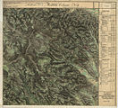
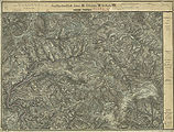
- historical maps of the municipality of Kloster from the three regional surveys in the period from approx. 1789 to 1910

southeastern Rettenbach and St. Oswald (top left) in the Josephinische Landesaufnahme , around 1790

Klosterwinkel and Hebalm around 1790

western Hebalm area in the Franziszeische Landesaufnahme , around 1835
St. Oswald, Klosterwinkel, around 1835 (far left)

Special map of the 3rd land survey , depiction 1894, partially corrected until 28th XI. 1913

Status 1937 (with forest railway line) with reporting grid.jpg
The west of the community with the Hebalm area 1877/78, recording sheet of the 3rd regional recording

St. Oswald in Freiland and Klosterwinkel 1877/78


Individual evidence
- ^ Styrian municipal structural reform .
- ↑ Section 3, Paragraph 2, Item 1 of the Act of December 17, 2013 on the reorganization of the municipalities of the State of Styria ( Styrian Municipal Structural Reform Act - StGsrG). Provincial Law Gazette for Styria of April 2, 2014. No. 31, year 2014. ZDB -ID 705127-x . P. 2.
- ^ Weekly newspaper Weststeirische Rundschau. November 22, 2013. Volume 86, No. 47. ZDB ID 2303595-X . Page 3.
- ↑ 248. Newsletter of the municipality of Deutschlandsberg from November 26, 2013.
- ↑ Landscape protection area 2: Ordinance of the Styrian state government of May 25, 1981, stmk. State Law Gazette No. 37/1981 in the version of the correction (new map display) No. 64/1981. Map of the protected area ( Memento of the original dated December 21, 2007 in the Internet Archive ) Info: The archive link was inserted automatically and has not yet been checked. Please check the original and archive link according to the instructions and then remove this notice. in the Digital Atlas Styria. Before that, protection existed under the ordinance of June 12, 1956, LGBl. No. 35, for the protection of parts of the landscape and the landscape (Landscape Protection Ordinance 1956) in the version of the ordinances LGBl. No. 57/1958, 125/1961, 185/1969, 96/1970, 14/1974, 147/1974 and 30/1975, with regard to Annex 1 Z 2.
- ^ Statistics Austria: Ortverzeichnis Steiermark 2001. Publisher and producer: Statistics Austria. Federal Statistics Austria. Commission publisher: Verlag Österreich GmbH, Vienna 2005, ISBN 3-902452-45-5 , page 64.
- ↑ Decree of the imperial-royal finance minister (high kk. Finance ministerial decree, h.kk.FME) of 6 August 1891, Zl. 23630.
- ↑ Communal announcement 1850: Decree of the governor of September 20, 1850, which announces the new local congregations established according to the provisional law of March 17, 1849 with their allocation to the political court and tax office districts in the Crown Land of Styria. General state law and government gazette for the Crown Land of Styria. I. year 1850. XXI. Item no. 378. Page 432. Supplement “Kreis Gratz” (supplement Graz). Pages 104–105 of this supplement.
-
^ Andreas Exner: The forest companies of the Hebalm area, northern Koralpe, Styria. Joannea Botany No. 3/2002. Publication by the Department of Botany of the Styrian State Museum Joanneum , Graz. Page 30 with further references to specialist literature on the climate of the area.
Provincial Environmental Information System (LUIS) of Styria: climatic regions C.2 Koralpe and B.4 eastern roofing of the Koralpe. - ↑ Johann Samuelersch, Johann Gottfried Gruber: General Encyclopedia of Sciences and Arts , Third Section O-Z, Seventh Part Osteolamacia-Otzenhausen Ed -Gruber 3/7, page 251 (bottom right) in the Google book search.
- ^ Margarete Sekera, Heinrich Hacker (editor), Max Eisenhut (mapping): Austrian soil mapping. Explanations for the soil map 1: 25,000. Mapping area Deutschlandsberg (KB 24) . Published by the Federal Ministry of Agriculture and Forestry (Federal Agricultural and Chemical Research Institute, Soil Mapping and Soil Management). Vienna 1975. Pages 150–158. As of 2007 under: Austrian soil mapping of the Federal Research and Training Center for Forests, Natural Hazards and Landscape - BFW, Federal Office for Forests.
- ^ Eduard Hatle: The minerals of the Duchy of Styria. Verlag Leuschner and Lubensky Graz 1885. Pages 106, 110 and 122.
- ↑ Josef Taucher, Christine Elisabeth Hollerer: The minerals of the federal state of Styria in Austria. Two volumes with CD-ROM. Hollerer, Graz 2001, ISBN 3-9501422-0-7 , Volume 2, page 438 (with references to the individual publications).
- ↑ Cultural property protection map 1: 50,000. Sheet 198 Deutschlandsberg. According to the Hague Convention of May 14, 1954, Federal Law Gazette No. 58/1964, edited by the Documentation Center and Convention Office of the Federal Monuments Office, Vienna 1977. Ordinance of the Federal Monuments Office of February 20, 2001, with the 117 immovable monuments of the political district of Deutschlandsberg, Styria, the are under monument protection by legal presumption, are placed under the provisions of § 2a Monument Protection Act. Official Gazette of the Wiener Zeitung, 2001. Ordinance sheet for the service area of the Federal Ministry of Education, Science and Culture, No. 64/2001, page 144. Vienna 2001. ISSN 1023-6937 .
- ^ Ordinance of the Styrian state government of September 13, 2004 (PDF) Styrian State Law Gazette No. 53 of September 30, 2004 (21st issue, page 218/2004).
- ^ District topography. Second part of the volume. District Lexicon. Page 170.
- ↑ The Rein Abbey near Graz was instrumental in the settlement of the Kainach Valley and Central Styria south of the Gleinalpe, cf. Reinischkogel. Othmar Pickl: Contributions to the economic history of the Rein Zisterze up to the beginning of modern times. In: Paulus Rappold (Ed.): Stift Rein 1129–1979. 850 years of culture and belief. Festschrift for the anniversary. Purely 1979. No ISBN. Pages 108-134. House names and family names, e.g. B. Reinisch, Reinischhans, Reinischwirt, were named after them, the first name was used to distinguish them.
- ↑ Community announcement 1850. Supplement "Kreis Gratz" (supplement Graz): Alphabetical directory of the Catastral and new local parishes of the Gratzer district in the Crown Land of Styria to the main overview announced with the Provincial Law and Government Gazette XXI, 1850. Page 129 with an explanation of the * on page 121.
- ↑ Otmar Pichler, Alexander Steiner: Austrian Official Calendar 2006/2007. The lexicon of authorities and institutions. 74th year (Court and State Handbook 118th year, Lower Austrian official calendar 130 year). Compiled from official and official sources. Vienna 2006. Verlag Österreich (formerly Verlag der k. U. K. Hof- und Staatsdruckerei). ISBN 3-7046-4888-4 . Page 1577.
- ^ Statistics Austria: A look at the community. .
- ↑ Explanation of the data sheets from Statistics Austria.
- ↑ From May 17, 1849. Austrian Reich Law Gazette No. 170/1849, pp. 203–222.
- ↑ Maximilian Riederer u. a .: Freiländer Ortschronik . Page 67.
- ^ Anton Mell: High and lower criminal jurisdictions. Regional courts and truces in Styria. In: Anton Mell, Hans Pirchegger: Styrian court descriptions . As sources for the Historical Atlas of the Austrian Alpine Countries. I. Department. District court map: Styria. In the series: Sources on the constitutional and administrative history of Styria. I. Volume. Published by the Historical State Commission for Styria. Graz 1914. General: Pages XX – XLIV. On the Admont castle keep: page 239 .
- ^ Gerhard Fischer: Osterwitz. a miraculous place in the high pürg. Life, joy and suffering of an area and its inhabitants. Osterwitz 2002. Editor and publisher: Osterwitz community. No ISBN. Page 39.
- ^ Gerhard Fischer: Osterwitz. Page 152.
- ↑ Maximilian Riederer u. a .: Freiländer Ortschronik . Page 25.
- ^ District topography. First volume: Gerhard Fischer: Peasantry, agriculture and forestry. Page 365.
- ^ Gerhard Fischer: Osterwitz. Page 335.
- ↑ Manfred Trummer: Slawische Steiermark = Slightly extended version of the lecture of the same name at the symposium “To be foreign - stay together. The Slovene Ethnic Group in Austria ”as part of the“ Slovene Days ”at the Karl-Franzens University in Graz, 25. – 28. March 1996. From: Christian Stenner (Ed.): Slovenian Styria. Displaced minority in Austria's southeast. Böhlau, Vienna / Cologne / Weimar 1997, ISBN 3-205-98690-3 , pages 15–34.
- ↑ The name "Laßnitz" is derived from the Slavic "Lieznica" and translated as "Waldbach". In linguistics, * loNč'nica "Wiesenbach" is also discussed for Laßnitz (890 Luonzniza) , as a further possibility (1345 Lesniz, Laßnitz near Murau or 1080 in Paltental Laznich) * laz'nica "Gereutbach". Gams: * Kamen'nica "Steinbach". Kautz: tkalec "Weber" also as: Tkauc, Tkavc, Tkautz, Kaue, Tkalcic, Kalcsics, Kavcic, Kautschitsch, Kautsch, Kautzsch, Kauch. Strehly: Slavic strelec, Sagittarius. Osterwitz: * ostrovica "Spitzberg". Gratzen: "grad" = castle in Old Church Slavonic , Slovenian and Croatian , "gradec" means "small castle" in Slovenian. For the origin of the name, see Graz .
- ^ Austrian Academy of Sciences. Center for Linguistics, Image and Sound Documentation. Institute for Austrian Dialect and Name Encyclopedias ( Memento of the original dated May 23, 2009 in the Internet Archive ) Info: The archive link was automatically inserted and not yet checked. Please check the original and archive link according to the instructions and then remove this notice. (DINAMLEX). Information from January 31 and February 27, 2008, see discussion at Klosterwinkel .
- ↑ Ursula Schachinger : The ancient coin circulation in Styria. In: Robert Göbl (Hrsg.): The coins found in the Roman period in Austria, Department VI: Styria. Austrian Academy of Sciences. Publications of the numismatic commission 43. Memorandum of the philosophical-historical class 341. Simultaneously: Historical Provincial Commission for Styria: Research on the historical regional studies of Styria Volume 49. Publishing house of the Austrian Academy of Sciences, Vienna 2006, ISBN 978-3-7001-3541-8 , Page 320 and (Consideration of a path over the Hebalm) Page 71. Also: Directory of the Styria site ( memento of the original from September 23, 2015 in the Internet Archive ) Info: The archive link was automatically inserted and not yet checked. Please check the original and archive link according to the instructions and then remove this notice. , Deutschlandsberg, 37 Kloster (accessed June 2, 2010).
- ↑ V (áclav, including: Wenzel) Radimský, Joseph Szombathy: Prehistoric Research in the neighborhood of Wiesbaden in central Styria. III. Continuation of the report on the excavations in 1881, 1882 and 1883. In: Franz Hauer (Red.): Mitteilungen der Anthropologische Gesellschaft (MAG). Volume XVIII (Volume VIII of the new series) year 1888. Pages 77–108, here: page 102.
- ^ District topography. First part of the volume. Werner Tscherne: Commerce, trade and industry. Pages 381-382.
- ↑ a b c d Maximilian Riederer u. a .: Freiländer Ortschronik . Pages 26-35.
- ^ District topography. First volume: Gernot Peter Obersteiner: Settlement, administration and jurisdiction until 1848. Page 64.
- ^ Horst Schweigert: The art monuments of Austria. Dehio manual. Graz. Published by the Institute for Austrian Art Research of the Federal Monuments Office. Verlag Anton Schroll Co. Vienna 1979. ISBN 3-7031-0475-9 . Pages 254-259.
- ^ Manfred Straka: Numbering sections and advertising districts of Styria 1779/81. Maps on a scale of 1: 300,000. In: Historical Atlas of Styria . Published by the Historical Commission for Styria (HLK). Akademische Druck- und Verlagsanstalt, Graz 1977. 1st delivery: administrative boundaries and population development in Styria 1770–1850. Sheet 2 (sheet north).
- ^ Manfred Straka: Tax communities and advertising districts of Styria 1798–1810. Maps on a scale of 1: 300,000. In: Historical Atlas of Styria . Published by the Historical Commission for Styria (HLK). Akademische Druck- und Verlagsanstalt , Graz 1977. 1st delivery: administrative boundaries and population development in Styria 1770–1850. Sheet 4 (sheet north)
- ^ Manfred Straka: cadastral communities and advertising districts of Styria 1818–1848. Maps on a scale of 1: 300,000. In: Historical Atlas of Styria . Published by the Historical Commission for Styria (HLK). Akademische Druck- und Verlagsanstalt, Graz 1977. 1st delivery: administrative boundaries and population development in Styria 1770–1850. Sheet 6 (sheet north).
- ↑ Franz Pichler: The land register, land register records and land registers of Styria. Complete directory. With the exclusion of the dominions and authorities of the former Lower Styria. Taking into account the landscape tax registers, the “Validity 1542” and the Theresian tax rectification. Publications of the Steiermärkisches Landesarchives, Volume 3. No ISBN. Graz 1967–1979. Volume 3 / II KR Graz 1977: Section 746 St. Martin, Provostei des Admont Abbey. Pages 836-859.
- ^ Stamp imprint of the community as part of the Stainz district administration in: District topography. First part of the volume. Werner Tscherne : Administrative history since 1848. Page 84.
- ^ District topography. First part of the volume. Werner Tscherne: Administrative history since 1848. Pages 87–89.
- ^ Communication from Fr. LM-S.
- ^ District topography. General part. Herbert Blatnik: The First World War and the new state border. Page 144. That this was the 12th Isonzo battle and November (from the context of the text: 1917) should be checked: The battle mentioned took place in October.
- ↑ Christian Fleck: Koralmpartisanen - About different careers of politically motivated resistance fighters. Ludwig Boltzmann Institute for Historical Social Science, Materials on Historical Social Science Volume 4. Böhlau, Vienna / Cologne 1986, ISBN 3-205-07078-X .
- ↑ Herbert Blatnik: Contemporary witnesses remember the years 1938–1945 in Southwest Styria. 2nd Edition. Lerchhaus, Eibiswald December 2000. Pages 242–243. ISBN 3-901463-08-9 .
- ↑ Memorial of the Catholic Couleur Students (in the reception area) Vienna 8, Lerchenfelderstrasse 14. Dr. Mooslechner was a member of the K.Ö.HV Carolina Graz , which commemorates him as an important member on its side.
- ↑ Fleck, Koralm partisans . Pages 129-131.
- ↑ Personal communications from older members of the congregation refer to this point independently for years.
- ↑ a b Gerhard Fischer: Osterwitz. Page 48.
-
^ Herbert Blatnik: Contemporary witnesses . Page 122.
District topography. First part of the volume. Herbert Blatnik: Third Reich, Second World War and Occupation. Pages 198-200. - ^ District topography. First volume: Herbert Blatnik: Third Reich, Second World War and the occupation. Page 195.
- ^ Herbert Blatnik: Contemporary witnesses . Page 481. Herbert Blatnik: The district of Deutschlandsberg. 11th part. Death from the air. In: Weekly newspaper Weststeirische Rundschau , July 1, 1995. No. 26. Page 12.
- ^ Gerhard Fischer: Osterwitz . Page 47.
- ^ Herbert Blatnik: Contemporary witnesses . Page 445.
- ^ Walter Brunner: The aerial warfare in Styria. 1941-1945. Air raid protection and aerial warfare in Styria. Air raid protection measures outside of the state capital . ( Page no longer available , search in web archives ) Info: The link was automatically marked as defective. Please check the link according to the instructions and then remove this notice. (PDF) Announcements from the Styrian Provincial Archives, Volume 38. Graz 1988. Page 108.
- ^ Brunner: Luftkrieg , page 109.
- ↑ Personal communication from a resident at the time, the exact date cannot be remembered. British and Soviet citizens were clearly distinguishable for them by the shape of the helmets and other clothing as well as by behavior (explorations, references to origin).
- ↑ Personal communication from a former resident.
- ↑ Contemporary witnesses report: How a Russian tank commander found his death in Mittereggerbach. In: Weekly newspaper Weststeirische Rundschau , March 2, 2018. No. 9. Page 3.
- ↑ The information from Mrs. Ida Kargl on the British Army in Kloster. In: Herbert Blatnik: Contemporary witnesses remember the years 1938–1945 in Southwest Styria. Pages 445-446.
- ↑ Maximilian Riederer u. a .: Freiländer Ortschronik . Page 101–104.
- ↑ Excerpts from the monthly reports of the district administration Deutschlandsberg, in: Fischer: Osterwitz . Page 424.
- ^ District topography. First part of the volume. Herbert Blatnik: Third Reich, Second World War and Occupation. Pages 201-205.
- ^ District topography. First part of the volume. Gerhard Fischer: peasantry, agriculture and forestry. Pages 326-328. Members of the UG Koralpe were farmers from the (then) communities of Deutschlandsberg , Freiland , Garanas , Gressenberg , Hollenegg , Kloster, Limberg , Osterwitz , Schwanberg , Soboth , St. Oswald ob Eibiswald , Trahütten , Wernersdorf , Wielfresen and Wies .
- ↑ Trade information system Austria: GISA number 19496825, former trade register number 6031566. End of trade license February 29, 2020.
- ↑ Aibl , Freiland , Garanas , Gressenberg , Großradl , Osterwitz , Soboth , St. Oswald ob Eibiswald , Trahütten , Wernersdorf and Wielfresen .
- ↑ Josef Fürbass: There is not enough good air . In: Neues Land, weekly newspaper of the Steirischer Bauernbund. No. 33 of August 17, 2007, page 3.
- ↑ Zoning plan in the Geographical Information System GIS of the State of Styria .
- ↑ § 14 as amended on November 16, 1999, stmk. LGBl. No. 14/2000 of February 29, 2000. 5th item. Page 66.
- ↑ Law of June 25, 1974 on spatial planning in the state of Styria (Styrian spatial planning law 1974), styria. LGBl. No. 127/1974, repeatedly amended. Stand under Styrian state law .
- ^ Ordinance of the Styrian Provincial Government of December 7, 2009, styrian. LGBl. No. 102/2009 of December 21, 2009 - Local Class Ordinance (34th issue, page 458), previously: Ordinance of the Styrian Provincial Government of March 17, 2003, styrian. LGBl. No. 25/2003 of April 11, 2003 (7th issue, page 93.)
- ↑ Section 4, Paragraph 1 of the Agriculture Act, Federal Law Gazette No. 375/1992 on the basis of Art. 3 Paragraph 3 of EEC Directive 75/268. Ordinance of the Federal Minister for Agriculture and Forestry on the definition of mountain areas and disadvantaged areas worthy of support, Federal Law Gazette No. 771/1995 (CELEX no .: 395L0212).
- ↑ Ordinance of the Federal Minister for Agriculture and Forestry, with which the mountain farms in Styria are determined, Federal Law Gazette No. 1052/1994.
- ↑ Austrian Federal Law Gazette No. 477/1995.
- ↑ a b District Court of Deutschlandsberg. Land register of the cadastral community 61027 Klosterwinkel, deposit number 21.
- ↑ Walter Brunner: The Gmein in the Styrian Altsiedelland. In: Gerhard Pferschy: settlement, power and economy. Festschrift Fritz Posch for his 70th birthday. Publications of the Styrian regional archive. Volume 12. Graz 1982. No ISBN. Pages 45-50.
- ↑ Ordinance on the authorization of the mayor of the municipalities ..., monastery, ... to perform certain official acts under passport law, in accordance with §§ 16 Paragraph 3 and 19 Paragraph 6 of the Passport Act 1992, Federal Law Gazette No. 839, last amended by Federal Law Gazette I No. 44/2001. Announced in: Grazer Zeitung, page 695/2001
- ↑ Section 361, Paragraph 4 of the General Social Insurance Act-ASVG, sozdok.at: If the application is submitted to a municipality, it is to be forwarded to an insurance company without unnecessary delay depending on the request and applies if between submission to the municipality and receipt no more than two months have elapsed with an insurance company, with the day of receipt by the municipality as filed with the responsible insurance company.
- ↑ Ordinance of the Federal Minister for Science and Research on the accessibility of study locations according to the Study Funding Act 1992, Federal Law Gazette No. 605/1993 of August 31, 1993. This regulation was retained even after the merger of the municipality with Deutschlandsberg at least until 2016: Federal Law Gazette II No. 45/2015 : Ordinance of the Federal Minister for Science, Research and Economy, with which the ordinance on the accessibility of study locations according to the Study Funding Act 1992 is changed.
- ↑ Founded by Alexander Kortschak from Leibnitz in 1865, one of the pioneers of tourism in the Koralpen region, later continued by Therese Kortschak (see bus course books of the 1930s). Werner Tscherne: From Lonsperch to Deutschlandsberg. Editor and publisher: Stadtgemeinde Deutschlandsberg, 1990. Page 309.
- ↑ Werner Tscherne: Lonsperch. Page 391.
- ^ Anton Reinbacher: 70 years of GKB bus operation. In: The turntable. The employee magazine of Graz-Köflacher Bahn- und Busbetrieb GmbH. Issue 20, April 2005. Pages 2–3. Abridged and amended version of an article by this author in Omnibusspiegel 1992.
- ^ Official Austrian course book, 2nd part: Motor vehicle lines in Austria. Summer timetable 1956, valid from June 3, 1956 to September 29, 1956. Published by the Federal Ministry of Transport, General Directorate of the Austrian State Railways. P. 285.
- ^ Official Austrian course book, motor vehicle lines, annual timetable 1961/62. Ed .: General Directorate of the Austrian Federal Railways. Vienna 1961. p. 260.
- ↑ Richard Zimmerl: Permit, Deutschlandsberg. In: Die Briefmarken, Philatelic trade journal. Volume 43, September 1995. Pages 18-27.
- ^ History of the Raiffeisenkasse Deutschlandsberg .
- ↑ Transmitter register .
- ^ Cemetery of the parish of St. Oswald (accessed June 14, 2011).
- ↑ Out and about in Deutschlandsberg. The Steffelbauer tells… In: Weekly newspaper “Weststeirische Rundschau” from March 16, 2012. 85th year No. 11. p. 3.
- ↑ 40 years of Klug-Lifte Hebalm-Freiländeralm. In: Weekly newspaper “Weststeirische Rundschau” from March 7, 2009. Volume 82, No. 10. Page 4.
- ^ Viktor Herbert Pöttler: The house landscapes of Styria. Explanations of the Atlas of Styria. Graz 1973. Pages 215-229.
- ↑ Ordinance of the Federal Minister for Agriculture and Forestry on forest reproductive material, Federal Law Gazette No. 512/1996 of September 26, 1996.
- ^ District topography. First part of the volume. Werner Tscherne: Commerce, trade and industry. Pages 383-385.
- ↑ As an example, a case from the field in the 1930s: District topography: first volume. Gerhard Fischer: peasantry, agriculture and forestry. Page 326.
- ↑ at vlg. Strehly west on a railing rib near the tributary to the Gratzenbach , at vlg. Zachthoma above Hebalmstraße next to a spring on the way.
- ^ Message from Ms. LM-S., A resident of the farm at the time, vlg. Gratzen that alerted the fire fighters.
- ↑ Styrian Hunting Law 1986, stmk. Provincial Law Gazette No. 23/1986, changed several times, see legal information system for the latest version, entry “Styrian Hunting Law”.
- ^ Weekly newspaper Weststeirische Rundschau . No. 50 of December 17, 2010. Volume 83, 2010. Page 1.
- ↑ Styrian municipal code in the version of the amendment in the State Law Gazette No. 92, issued on September 4, 2008, issue 27, page 304 in conjunction with Section 2, Paragraph 1 of the Styrian. Municipal Association Organization Act (GVOG) 1997.

Bad Schwanberg | Deutschlandsberg | Eibiswald | Frauental an der Laßnitz | Great Saint Florian | Lannach | Pölfing-Brunn | Preding | Sankt Josef (West Styria) | Sankt Martin im Sulmtal | Sankt Peter im Sulmtal | Sankt Stefan ob Stainz | Stainz | Wettmannstätten | Wies
93 Former communities (dissolved since 1945):
Aibl |
Aigen |
Bad Gams |
Blumegg |
Breitenbach in West Styria |
Dietmannsdorf im Sulmtal |
Ettendorf near Stainz |
Feisternitz |
Field tree |
Freidorf an der Laßnitz |
Open field near Deutschlandsberg |
Gamsgebirge |
Garanas |
Gasselsdorf |
Georgsberg |
Gersdorf |
Grafendorf near Stainz |
Graggerer |
Grass shoe |
Greisdorf |
Greith |
Gressenberg |
Großradl |
Grub near Groß Sankt Florian |
Grünau an der Laßnitz |
Gundersdorf |
Gussendorf |
Hasreith |
Herbersdorf |
Hollenegg |
Kleinradl |
Monastery |
Kornriegl |
Kothvogel |
Kraubath (West Styria) |
Krottendorf an der Laßnitz |
Kruckenberg |
Laaken |
Lasselsdorf |
Lebing |
Limberg near Wies |
Mainsdorf |
Marhof |
Mettersdorf |
Michlgleinz |
Nassau |
Neudorf near Stainz |
Neurath |
Niedergams |
Oberhart |
Upper Latin |
Oisnitz |
Osterwitz |
Otternitz |
Petzelsdorf in West Styria |
Pichling at Stainz |
Pirkhof |
Pitschgau |
Rassach |
Rossegg |
Rostock |
Red wine |
Sankt Oswald ob Eibiswald |
Sankt Ulrich in Greith |
Schönaich |
Sierling |
Soboth |
Stainztal |
Stable yard |
Stammeregg |
Sterglegg |
Sulmeck-Greith |
Sulz |
Sulz-Laufenegg |
Tanzelsdorf |
Teipl |
Tobis |
Tobisegg |
Trahütten |
Trough |
Unterbergla |
Vochera am Weinberg |
Vochera an der Laßnitz |
Front village |
Forest in West Styria |
Wernersdorf |
Wetzelsdorf in West Styria |
Wielfresen |
Wieselsdorf |
Torrent |
Wohlsdorf |
Zeierling |
Zirknitz