
Sankt Oswald in Freiland
St. Oswald in Freiland is the name of the central place of the Kloster area in the west of the community of Deutschlandsberg in the district of Deutschlandsberg in Styria , Austria . The parish also bears the name of St. Oswald in Freiland .

geography
The place lies on the eastern ridge of the Schwarzkogel (Wolfsriegel) in the cadastral community of Klosterwinkel . In addition to Klosterwinkel, the parish's territory also includes the second cadastral parish of the former Kloster parish, Rettenbach.

The location of Kloster meant that a number of farms in the Osterwitz community , Osterwitz-Winkel district (including Pöschl, Kleinreinisch, Stoff and Stefflpeterkeusche / Pust) had shorter and better road connections to St. Oswald and their own communities.
The children of these Osterwitzer Höfe attended the school in St. Oswald (partly with, partly without the approval of the school authorities). Those who died from these areas were and are buried in the St. Oswald cemetery. The same applied to a number of farms in the valley of the torrent in the cadastral parish of Sallegg of the former municipality of Bad Gams , for which St. Oswald was officially named as the parish together with Gams in the official announcement in 1850. This was also the case in the municipality register of Styria in 1868.
St. Oswald consists of around 50 residential and farm buildings. The former municipal office, which will continue to be used for administrative purposes from 2015, and the elementary school are housed in a common building, and a multi-purpose hall is used for various social events. Two restaurants ( vlg. "Triftweber" and "Steffelbauer") are located in the village, as is the location of a freight company that focuses on timber transport (Horvath company).
Culture and sights
Parish church
The Roman Catholic Church of St. Oswald in Freiland was mentioned in a document in 1434 as a subsidiary church of St. Jakob in Freiland and in 1892 it was elevated to a parish church. It is a listed building.
Ciborium of St. Oswald
The ciborium of St. Oswald is a late Gothic dining cup ( ciborium ) made of silver with a gold-plated insert. It is kept in the Graz Diocesan Museum. The ciborium is 43.2 cm high and has a canopy made of tracery on the lid with pegs , crabs , eyelashes and a donkey back arch , which encloses a statue of Christ as the Man of Sorrows . The date of origin is given as the end of the 15th century or the period from 1480 to 1520, the shape is traced back to the reconstruction of the drinking cup of an Admont prelate .
Names
The official spelling for place and parish is “St. Oswald in Freiland “(consciously in , not in ). In everyday life, the variant “St. Oswald im Freiland ”. The designation "in the field" means the simple geographical indication of the area in which the place is located, without going into the statements associated with this designation (e.g. whether manorial, parish, etc. are meant). According to the Duden, a spelling with "im" refers to something already mentioned, known, accessible, with "in" not. The “m” comes from the article “dem”, which reinforces the statement. The variant with m is reminiscent of the history of the place: The designation “in the open land” includes the main meaning “in the free land”, ie the description of the location in a specific area, “in the manorial estate of Freiland (of Admont Abbey)” in a specific administrative unit.

The name is often “St. Oswald i. Freiland “written. The abbreviation "i." Is usually not due to space problems (especially not with fonts with the same increment , as was common on typewriters in the 20th century), but rather because the subject "m or n" is avoided.
There is also the spelling “St. Oswald ob Freiland ”. This variant is based on the fact that St. Oswald (as seen from the district capital) lies above Freiland ( whether for Ober , as with St. Oswald ob Eibiswald). In everyday life, no precise distinction is made between the name variants.
To distinguish from
- St. Oswald ob Eibiswald (this place is also in the Deutschlandsberg district , approx. 20 km south as the crow flies ) and
- St. Oswald bei Plankenwarth (this place is also in western Styria , approx. 30 km northeast, west of Graz)
the variants “St. Oswald (monastery) ”or“ St. Oswald / Kloster ”is used. The spelling “St. Oswald / Fr. ”Is only used within Styria because it can cause confusion with the place“ St. Oswald bei Freistadt ”in Upper Austria . In documents dating from the time of the Austro-Hungarian monarchy , confusion with the place St. Oswald an der Drau ( St. Oswald im Drauwalde, Ožbalt , in Slovenia , approx. 30 km southeast) is possible because western Styria and the Drautal were then in the Marburg district : The parish is incorrectly presented in older literature as the locality of the parish of St. Oswald near Mahrenberg.

Camp of the Reich Labor Service
During the Second World War there was a camp of the Reich Labor Service (RAD) in the town of St. Oswald , whose residents had to expand the road connection to Bad Gams (Klosterwinkelstraße, today's Landesstraße 645). In the years 1944 and 1945, conflicts arose between the camp residents and partisans from what was then Yugoslavia . This group had received partial support from the population. It was also joined by some deserted German soldiers. In the course of these conflicts, on Easter Sunday, April 1, 1945, by order of the Deutschlandsberg district leader Hugo Suette, five resistance fighters were captured by residents of the RAD camp and shot in the area of the camp. This act was dealt with in the Graz partisan murder trial.
photos
Garden land in the community center

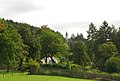
The local area of St. Oswald

West portal of the parish church St. Oswald in Freiland

Parish church with church linden tree and parish farm building

Church from the south
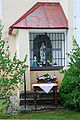
Marienkapelle on the south side of the church tower
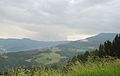
St. Oswald on the Wolfsriegel, on the right the summit of the Schwarzkogel

St. Oswald cemetery


Web links
credentials
- ^ Gerhard Fischer: Osterwitz. a miraculous place in the high pürg. Life, joy and suffering of an area and its inhabitants. Osterwitz 2002. Editor and publisher: Osterwitz community. No ISBN. Page 39.
- ^ Gerhard Fischer: Osterwitz. Page 152.
- ^ Supplement Graz , Law Gazette for the Duchy of Styria, born in 1850 (municipality structure).
- ^ Political division of the Duchy of Styria , announcement of the Imperial and Royal Governor of Styria of October 31, 1868, with which the detailed overview of the division of the Duchy of Styria is brought to the knowledge of the political and judicial organization of the Duchy of Styria, Provincial Law and Ordinance Gazette of the Duchy of Styria of April 21, 1869, XX. Piece, No. 36, p. 59 and appendix.
- ↑ Maximilian Riederer, Gunther Riedlsperger, Johann Tomaschek: Freiländer Ortschronik . Self-published by the community of Freiland near Deutschlandsberg, 1988. No ISBN. Page 227.
- ↑ a b Heimo Kaindl: Diözesanmuseum Graz. Selection catalog. Graz 1994. No ISBN. Pages 60–61 (with picture).
- ↑ Heimo Kaindl: Eins + 385. Church art to be amazed. A handbook of church art treasures. Exhibition catalog Graz 2008. ISBN 978-3-901810-21-3 . Pages 71–72 (illustration no.116).
- ^ Adolf Bischofberger: Mountain pilgrimage 1925, quoted from: Gunther Riedlsperger: A "mountain pilgrimage": Deutschlandsberg-Freiland-Kloster-Osterwitz, 3rd part. In: Weekly newspaper “Weststeirische Rundschau” from July 20, 1996. No. 29. Page 14.
- ↑ Otmar Pichler, Alexander Steiner: Austrian Official Calendar 2006/2007. The lexicon of authorities and institutions. 74th year (Court and State Handbook 118th year, Lower Austrian official calendar 130th year). Compiled from official and official sources. Vienna 2006. Verlag Österreich (formerly Verlag der k. U. K. Hof- und Staatsdruckerei). ISBN 3-7046-4888-4 . Page 1577.
- ^ Peter Eisenberg, Franziska Münzberg, Kathrin Kunkel-Razum: Duden. Correct and good German. Dictionary of linguistic cases of doubt. 6th completely revised edition. Duden Volume 9. Dudenverlag Bibliographisches Institut & FABrockhaus AG. Mannheim 2007. ISBN 978-3-411-04096-4 . Keyword in / in. Page 463.
- ↑ Duden. Correct and good German. Dictionary of linguistic cases of doubt. 6th edition. Keyword “geographical names”, point 2.1. Page 375.
- ^ Franz Raffelsperger (Ed.): General geographical lexicon of the Austrian imperial state. In an alphabetical order. According to all sources and the best patriotic relief organizations, from a society of geographers, postmen. Vienna 1847. In the main publishing house of the kkap typo-geographical art establishment Leopoldstadt Institute building no. 237. page 588. Raffelsperger, gen. Geogr. Lexicon 1847 in the Google book search Already at Carl Schmutz: Steyermärkisches Lexicon - Historisch-topographisches Lexicon von Steyermark. Printed by Andreas Kienreich Gratz in 1822. Third part N – Se, page 87 Schmutz, hist.-topogr. Lexicon 1822 in the Google book search
- ↑ Christian Fleck: Koralmpartisanen - About different careers of politically motivated resistance fighters. Ludwig Boltzmann Institute for Historical Social Science, materials on historical social science Volume 4. Verlag Böhlau. Vienna-Cologne 1986. ISBN 3-205-07078-X .
-
^ Herbert Blatnik: Contemporary witnesses . Page 122.
District topography. First part of the volume. Herbert Blatnik: Third Reich, Second World War and Occupation. Pages 198-200.
Coordinates: 46 ° 53 ' N , 15 ° 6' E