
Wildbach (Laßnitz)
|
Hohe Laßnitz torrent ; Upper course: Wildbachgraben |
||
 The torrent rises on the Reinischkogel with a number of source streams |
||
| Data | ||
| location | In the middle part of the Koralpe in western Styria , Austria | |
| River system | Danube | |
| Drain over | Laßnitz → Sulm → Mur → Drau → Danube → Black Sea | |
| source | On the southern slope of the Reinischkogel ( 1463 m above sea level ) 46 ° 55 ′ 28 ″ N , 15 ° 6 ′ 47 ″ E |
|
| Source height | 1400 m above sea level A. | |
| muzzle | In Frauental an der Laßnitz in the Laßnitz coordinates: 46 ° 49 '40 " N , 15 ° 15' 49" E 46 ° 49 '40 " N , 15 ° 15' 49" E |
|
| Mouth height | 330 m above sea level A. | |
| Height difference | 1070 m | |
| Bottom slope | 51 ‰ | |
| length | 20.9 km | |
| Catchment area | 50.6 km² | |
| Drain |
MQ |
200 l / s |
| Left tributaries |
Klosterbach (confluence at river kilometer 4 from the source), Gamsbach (Fkm 18) |
|
| Small towns | Deutschlandsberg | |
| Communities | Frauental on the Laßnitz | |
| Residents in the catchment area | 2500 | |
The torrent is a tributary of the Laßnitz in Styria , Austria .
geography
The river has its source on the southern slope of the Reinischkogel ( 1463 m above sea level ) in the central part of the Koralpe , flows steeply downhill to the southwest and after ten kilometers enters the flatter Graz basin . It then flows through the communities of Deutschlandsberg (Wildbach district) and Frauental an der Laßnitz to its confluence with the Laßnitz.
The upper course of the torrent is also known as the torrent ditch.
The upper Laßnitz , also known as the Niedere Laßnitz , flows parallel to the south of the torrent . Between Laßnitz / Niederer Laßnitz and Hoher Laßnitz / Wildbach there is a ridge on which the state road 606 (Hebalmstraße) runs and the villages of Kloster and Freiland near Deutschlandsberg are located. This ridge is partially only approx. 740 meters wide at the base, approx. 100 meters wide at the apex and slopes down to 180 meters on both sides into the two deeply cut river valleys.
Torrent towards the upper reaches: A deeply cut, often pathless valley

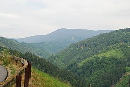
Wildbach towards Unterlauf: From Wildbach the valley opens up

On the lower reaches of the torrent in the village of Wildbach bei Deutschlandsberg


The upper course of the stream overcomes several hundred meters of difference in altitude in a few kilometers. This steep gradient has its reason in the formation of the Koralpe: Geologically, the Koralpe is an uplifted part of the mountain, a pult . From their mountain ridge (where the source areas are located), the watercourses have to overcome large differences in altitude over short stretches into the lowlands (in the case of the torrent: into the Graz basin ).
The steep slopes of the river valleys lead to landslides through which mineral discovery sites are opened up. Road constructions (especially for forest roads) and quarries also make discovery sites, e.g. B. for grenade , accessible. The sites are formed by around a hundred pegmatites of different thicknesses (from a decimeter range up to 20 meters and more). In them, uranium minerals ( uranium mica , autunite , torbernite , uraninite ), uranium opals, tourmaline , zircon , dumortierite and other minerals were found in small quantities with crystals of millimeter size ; Marble was quarried in several quarries in the Wildbachtal , one of the quarries delivered the first spodumene find in the Koralm area.
The composition of the rocks ( bed load ) in the bed of the torrent and its source streams has been scientifically investigated.

history

The generic term became a proper name for the torrent: The torrent is a torrent . The name Laßnitz is of Slavic origin. The change between Slavic and German names began with a wave of settlements from the 8th century from German-speaking areas in the context of the creation of the Karantanian Mark or in the context of the Salzburg possessions on the Sulm and Laßnitz rivers.
Information that calls a river Laßnitz in the area of the middle Koralpe is ambiguous: it can mean several bodies of water that belong to the same river system, but can be a few kilometers (and several hundred meters in altitude) apart: upper reaches of the Laßnitz , wild brook or Rettenbach : In the Josephinische Landesaufnahme 1787 the Laßnitz is shown as Groß Lasnitz Bach , the wild brook as Klein Lasnitz Bach . In linguistic usage, but also in maps, the torrent was also called Hohe Laßnitz until the 1980s . Later it was listed as a torrent (Hohe Laßnitz) . From around 1990 the maps only contain the name Wildbach. In older publications the torrent can also be referred to as Niedere Laßnitz and today's Rettenbach as Hohe Laßnitz . The name variants are due to the fact that in the 19th century the origin of the Laßnitz was also assumed to be on the Hebalm and thus the Rettenbach was seen as the upper reaches of the Laßnitz.
environment
The torrent shows no serious environmental impact.
Agricultural fertilization and settlement in the lower reaches have so far only resulted in low pollution from fertilizer residues.
The upper course of the torrent lies in a protected landscape area.
fauna
Brown trout live in the water itself .
Dragonflies and caddis flies live on the water of the upper reaches . Their larvae are a reliable indicator of water quality; they only occur in bodies of water with good to very good water quality.
flora
Rare plants grow in the upper reaches of the torrent: the Sturzbach Gemswurz and the mica saxifrage , which was only found in the area of the western Styrian peripheral mountains and its foothills (Koralpe, Bachergebirge ). It thrives in dry places under overhanging rocks, if possible without direct contact with precipitation water (rain, etc.) and does not tolerate strong light: the deeply cut valleys of the torrent and its tributaries are one of its areas of distribution.
An exceptionally low-lying location of plants has been documented in the area, which are commonly found in higher regions. This is put up for discussion as a relic of Ice Age vegetation conditions.
Water quality
The water quality in the upper reaches is quality class I-II (almost unpolluted), then quality class II, due to pollution from settlements and fertilization of agricultural areas.
The water hardness is low (range 1–2 - soft water).
Floors
The agriculturally usable soils are brown earth soils with almost all types of water supply from the Ranker to the Pseudogley . In the upper reaches, there are rock-brown soils made of crystalline slate as medium-quality arable and grassland, arable use only makes sense up to an altitude of 800–1000 m. From the village of Wildbach (former) auboils and silicate loose sediment brown earths exist, some of which are formed from tertiary sediment (Florianer Tegel ).
Sights and buildings
The castle of the same name is located on a small hill in the village of Wildbach : After the previous building was destroyed by the Turks, it was rebuilt in 1534–1540, and reconstruction took place in 1730–1788 (restricted viewing because it was privately owned). There are delicate rococo structures, Empire ovens, a chapel of St. Anna and a memorial to Franz Schubert's visit from 10th to 12th centuries. September 1827. It is not true, however, that parts of his trout quintet are said to have been made in this castle. This work was written around 1819, but was not published until 1829 after Schubert's death, and this attribution was made.
On the southern slope of the deeply cut Wildbach valley, the Hinterleitenstraße (as part of the state road 606 Hebalmstraße) overcomes between the end of the village Wildbach and the saddle at the vlg farm. Large with extensive safety structures and switchbacks, a height difference of approx. 400 meters. The road gradient of over 25% that had previously existed on this connection was only removed when this road was expanded between 1983 and 1986. Even after that, the connection is so steep that it is used for mountain races (mountain prizes from the Deutschlandsberg cycling club) that are part of the Austrian cycling championship.
economy
Agriculture and forestry (including alpine pasture and hunting) are the only year-round economic activity alongside hospitality and tourism businesses. Large industry is missing.
Emigration
The catchment area of the torrent on the upper reaches is a migration area . Several farms that were still working at the beginning of the 20th century were abandoned at the end of this century or only used as weekend or hunting lodgings or the farm building as a cattle shed (e.g. Gratzen, Rambacher). Other farms have become part-time businesses or are managed from other farms.
Agriculture
The soils in the upper reaches only allow arable farming to a limited extent due to the quality and altitude.
In the full-time mountain farms in the catchment area of the torrent, cattle breeding and grassland management dominate , in some cases cereals are grown (mainly barley and wheat, formerly also rye and oats). Potato and fodder beet cultivation , which was widespread until the 1960s, was discontinued.
The main cultivation animals on the farms are cattle and pigs. The most important cattle breeds are the Holstein and Simmental cattle . In addition , beef cattle breeds are bred with Charolais , white-blue Belgians and other breeds. Pig breeding mainly includes the Pietrain , Landrace and Edelschwein breeds . The Sulmtaler are common on chickens . Farm milk production and delivery to local dairies, formerly a main source of income for agriculture, has declined sharply over the past few decades in favor of beef production.
Red deer (stag), chamois, wild boar (wild boar) on the upper reaches and generally deer and hares are the most common larger wild animals in the catchment area of the torrent. Badgers have become rare. The fox is a common predatory game. The forest area in the upper reaches home to grouse (capercaillie). A common bird of prey that also beats free-range chickens and cats is the buzzard.
The lower reaches are dominated by the agricultural corn and pumpkin production. Pumpkin production is part of the production of seed oil .
In the area of the village Wildbach am Unterlauf des Wildbaches, the farm-gate sale of agricultural products (e.g. pumpkinseed oil ) and the Heurigen (Austrian for "Buschenschank") are an important source of agricultural income.
Sweet chestnuts grow in the mild climate on the lower reaches .
Viticulture
The torrent flows through the western Styria wine-growing region in the lower reaches . It is located in the core area of the Schilcher cultivation. This type of wine is made from the Blauer Wildbacher vine . This vine is named after the place Wildbach bei Deutschlandsberg (now part of Deutschlandsberg).
forestry
The forests on the torrent (mainly spruce, fir, red pines and larches, on hardwood linden and ash) are used by rural forestry operations.
Commercial establishments
At the course of the torrent and its tributaries there are some small power stations to supply neighboring farms and businesses. Until the beginning of the 20th century, the river's hydropower was also used by a number of mills and simple sawmills.
In Frauental an der Laßnitz there is a large ceramic factory (mainly industrial porcelain such as insulators).
statistics
Average flow rate : 0.2 m³ / s.
Individual evidence
- ↑ Extract from the digital Styrian body of water index. State of Styria , accessed on July 6, 2018 .
- ↑ BMLFUW (ed.) : List of areas of the Austrian river basins: Mur area. In: Contributions to the hydrography of Austria. Issue No. 60, Vienna 2011, p. 101 ( PDF download , accessed on July 6, 2018).
- ↑ a b Helmut Höller: A spodumene beryl pegmatite and a mineral-rich marble in the torrent ditch near Deutschlandsberg. Bulletin of the Department of Mineralogy in the Landesmuseum Joanneum 1/1959, Graz, page 19.
- ↑ There is a second torrent ditch, today Hofbauergraben , east of the torrent saddle at the Wildbachalm.
- ↑ Arthur Winkler-Hermaden a. a .: Scientific study results of the working group for geological-pedological investigations in the catchment area of the Laßnitz river in south-western Styria. Austrian Academy of Sciences, mathematical and natural science class, Dept. I, 149. Issue 7-10, pages 225-226. Vienna. Peter Beck-Managetta: About the geological structure of the Koralpe. In: G (ernot) Weissensteiner: Minerals of the Koralpe . 1. Special volume of the club magazine Die Eisenblüte . Association of Styrian Mineral Collectors, Graz 1979, page 6.
- ↑ G (ernot) Weissensteiner: Minerals of the Koralpe . 1. Special volume of the club magazine Die Eisenblüte . Association of Styrian Mineral Collectors, Graz 1979.
- ^ Gerhard Niedermayr, Walter Postl, Franz Walter: New Mineral Finds from Austria XXXII. In: Carinthia II. Communications from the Natural Science Association for Carinthia. 173/93. Year, Klagenfurt 1983, point 549, pp. 356-357 ( PDF on ZOBODAT ).
- ↑ Gernot Weissensteiner: Mineral finds from the "Hohen Lassnitz", Koralpe. In: The Styrian Mineralogist. Collector's magazine for mineralogy and paleontology. Published by the Association of Styrian Mineral Collectors - VStM Graz. Year 10/2000, issue 14, ZDB -ID 2009994-0 , pages 9-14.
- ↑ Gerda Woletz: The bed load conditions of the Laßnitz , in: Artur Winkler-Hermaden, Peter Beck-Mannagetta, Karl Bistritschan, Gerda Woletz, Karl Schoklitsch, Herbert Pichler: Scientific study results of the working group for geological-pedological investigations in the catchment area of the Laßnitz river in southwest Styria. Session reports of the Academy of Sciences in Vienna, mathematical and natural science class, Department 1, Volume 149, Issue 7 to 10 (presented at the session on June 27, 1940). Verlag Hölder-Pichler-Tempsky, Vienna 1940, pages 245-257 (data on the Wildbach and Klosterbach on pages 249-252).
- ^ Josephinische Landesaufnahme 1787, in: Historische Karten , Digitaler Atlas Steiermark, Geografisches Informationssystem GIS des Landes Steiermark.
- ^ On the title page of the Austrian map 1:25 000 - ÖK 25 V. Published by the Federal Office for Metrology and Surveying (Landesaufnahme) in Vienna. Sheet 189 Deutschlandsberg. Recorded in 1983.
- ^ Austrian map 1: 200 000. Sheet 47/15 Graz. Status 1983/1984, individual supplements until 1987.
- ^ Austrian map 1:50 000 - ÖK 50, sheet 189 Deutschlandsberg. New in 1983, map continuation in 1991.
- ↑ Maximilian Riederer, Gunther Riedlsperger, Johann Tomaschek: Freiländer Ortschronik . Self-published by the community of Freiland near Deutschlandsberg in 1988. Page 195, with a reference to Josef Andreas Janisch: Topographical-statistical lexicon of Styria with historical notes and comments Graz, Verlag Leykam-Josefsthal 1878-85. Volume 1: AK. 1878-. VIII, 821 pages. Volume 2: LR. 1885. 793 pages (32 plates). Reprint: Verlag für Collectors , Graz 1978–1979.
- ↑ Landscape protection area 02: Pack-Reinischkogel-Rosenkogel. Ordinance of the Styrian state government of May 25, 1981, styrian. State Law Gazette No. 37/1981 in the version of the correction (new map display) No. 64/1981. Map of the protected area ( Memento of the original dated December 21, 2007 in the Internet Archive ) Info: The archive link was inserted automatically and has not yet been checked. Please check the original and archive link according to the instructions and then remove this notice. in the Digital Atlas Styria.
- ↑ Pictures under Flora-Austria ( Memento of the original from October 8, 2007 in the Internet Archive ) Info: The archive link has been inserted automatically and has not yet been checked. Please check the original and archive link according to the instructions and then remove this notice. and under Saxifraga .
- ^ Arnold Zimmermann: A low-lying occurrence of subalpine-alpine plant families in the torrent ditch of the Koralpe (Styria). In: Communications from the Natural Science Association for Styria. Volume 106, Graz 1976, ISSN 0369-1136 , ZDB -ID 206167-3 , pp. 201-208 (accessed April 6, 2015).
- ^ Margarete Sekera, Heinrich Hacker (editor), Max Eisenhut (mapping): Austrian soil mapping. Explanations of the soil map 1:25 000. Deutschlandsberg mapping area (KB 24) . Published by the Federal Ministry of Agriculture and Forestry (Federal Agricultural and Chemical Research Institute, Soil Mapping and Soil Management). Vienna 1975. Pages 150–158. As of 2007 under: Austrian soil mapping of the Federal Research and Training Center for Forests, Natural Hazards and Landscape - BFW, Federal Office for Forests.
- ^ Kurt Woisetschläger, Peter Krenn: Dehio-Handbuch: Steiermark (without Graz). The art monuments of Austria - topographical inventory of monuments. Published by the Federal Monuments Office, Department for Monument Research. Verlag Anton Schroll, Vienna 1982, ISBN 3-7031-0532-1 , pages 618–619.
- ^ Gunther Riedlsperger: Castles and mansions in the paradise of Styria, Deutschlandsberg district. Publishing house Simadruck Weststeirische Rundschau Aigner & Weisi OHG, Deutschlandsberg 1996, page 31.
- ↑ The formerly independent community of Wildbach was merged with the town of Deutschlandsberg on January 1, 1970: Announcement of the Styrian state government of December 15, 1969, styria. State Law Gazette No. 226/1969.