
Reinischkogel (Lavanttal Alps)
| Reinischkogel | ||
|---|---|---|
 Reinischkogel (before that St. Oswald in Freiland ) |
||
| height | 1463 m above sea level A. | |
| location | Deutschlandsberg District , Styria , Austria | |
| Mountains | Koralpe | |
| Dominance | 3.05 km → Münzerkogel | |
| Notch height | 208 m ↓ Schrogentor | |
| Coordinates | 46 ° 55 '40 " N , 15 ° 6' 53" E | |
|
||
| rock | Crystalline | |
| Development | Hiking trails | |

The Reinischkogel is 1463 m above sea level. A. high mountain of the Koralpe in the Lavanttaler Alps in Styria . Its name is derived from the fact that extensive lands and farms north of it belonged to the Rein Abbey in the Middle Ages and the mountain formed its southern border (areas south of the Reinischkogel were areas that were assigned to the Admont Abbey ).
The word " Kogel " is due to the rounded summit . A round summit structure is referred to in geomorphology as a dome , the name can be combined with Kuppe / Koppe (probably from Latin cuppa “mug”), or Kogel / Kofel (cf. “Kugel”), Kopf / Köpfel , Nock , Gupf or Kulm ( Latin culmen , "high point").
geography
The Reinischkogel forms the beginning of a spur in the north of the coral range to the east. In the northeast lies the valley of the Stainzbach , in the southeast lies the valley of the wild brook , these streams flow into the Laßnitz . In the west lies the Modriachbach, which belongs to the catchment area of the Kainach .
The next higher peak is the 1510 m high Münzerkogel in the west southwest.
In the area of the Reinischkogel summit, the borders of the communities Edelschrott (west and north), Stainz (north and east), Deutschlandsberg (southeast and south) meet . The border between the political districts of Deutschlandsberg and Voitsberg runs across the Reinischkogel .
The Reinischkogel is almost completely forested in the summit region, except for a small mountain meadow, and there are only a few farms on its slopes. The next larger towns are Stainz in the east (about 10 km as the crow flies ) and Voitsberg in the north (about 13 km as the crow flies).
The slopes of the Reinischkogel are accessed in the south by the state road LH 645 Sallegger Straße from Bad Gams and Stainz from the direction of Klosterwinkel and St. Oswald in Freiland . An access road leads to the Reinischwirt (older name vlg. Buchenreinisch) in the southwest of the summit. From there, the summit of the Reinischkogel can be reached in about two kilometers. Around the Reinischkogel there are a number of unmarked forest roads that are not open to general traffic.
In the southeast of the summit there is a meadow, the Reinischkogel cross and a small wooden chapel in the area of the former municipality of Kloster . Summit masses are held there. The highest point of the Reinischkogel is in the forest about 300 meters northeast of it. A wayside cross, the "Kaltenbrunner Kreuz", stands in the area of the municipality of Stainz at the crossroads of the hiking trails east of the summit. It is dated 1868 and was renovated in 1986. The source of the Stainzbach is located near this cross.
The Schrattelofen , a striking boulder that is under nature protection, is located on the southern slope . Another natural monument on this slope was a multi-topped spruce, which was no longer listed as a natural monument in 2015.
The Reinischkogel is located in a conservation area .
- Reinischkogel
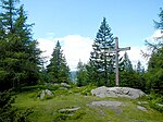
Summit cross

Reinischkogel Chapel

Meadow in the summit area
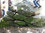
weathered block of gneiss
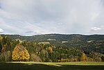
Reinischkogel from Wildbachtal

Bell of the Reinischkogel chapel

The Schrattelofen on the southeast slope of the Reinischkogel


geology
The Reinischkogel forms a flat crest made of coarse rubble that has arisen from the weathering of the bedrock. On its slopes, some rugged rock forms made of plate gneiss , so-called ovens, have been preserved . The mountain is formed from the crystalline of the Koralpenzuges (Koralpen or Koralm crystalline), in the southwest amphibolite or eclogite is in several places . The rocks of the Reinischkogel are rocks that were reshaped in the course of the mountain formation ( metamorphic rock ).
Like the entire Koralpe, the Reinischkogel has been thoroughly geologically investigated because this mountain range has influenced the current appearance of the Alps at their eastern end. At the foot of the Reinischkogel in the Wildbachtal, around one hundred sites of pegmatites of various thicknesses (from a decimeter range up to 20 meters and more) have been published in the Sallegg cadastral community . In them, uranium minerals ( autunite , torbernite , uraninite ), uranium opals, tourmaline , zircon , dumortierite and other minerals were found in small quantities with crystals in millimeter size .
history
The name "Absetzwirt" east of the Reinischkogel is evidence of an old traffic connection: The name refers to the "setting down" (unloading) of (load) loads. The Abetzwirt was a place where load transports took a break or where loads were transferred from one means of transport to another. This is because not all carters were allowed to leave the area of their manorial rule and therefore transports to borders had to be handed over to other transporters.
The Schrogentor in the southwest of the Reinischkogel is located on an old road between northern and southern western Styria. It is named after some of the rock formations in its area, greater Schrogen ( Schrofen ).
In the 18th and 19th centuries, the border between the Marburger Kreis and the Grazer Kreis ran across the Reinischkogel, and in the 17th century it belonged to the southern border of the Judenburger Kreis (at that time the area around Voitsberg belonged to this district).
In 1225 a road from Gams is mentioned, which went over the Greim area (and thus further over the southern slope of the Reinischkogel) to the Hebalm - the "Greimstraße".
The rock of the Reinischkogel contains deposits of quartz . In the 17th century in the northeast of the Reinischkogel in the area of the former municipality of Greisdorf in the area of the Klugbauer estate there was (at least) a glass production facility, the remains of which are listed. Your position was examined in more detail from 2010. Remains of a combined glass melting and cooling furnace and a stretching furnace for the production of flat glass were found. The reason for their construction is also the abundance of wood in the area, which generally made wood available for firing and beech wood for the production of potash .
Web links
Individual evidence
- ↑ Fritz Lochner v. Hüttenbach: Styrian place names. On the origin and interpretation of names of settlements, mountains, waters and fields. Graz Comparative Works ZDB -ID 2083885-2 Volume 21. Leykam Graz 2008. ISBN 978-3-7011-0116-0 . P. 146.
- ↑ West Styrian Rundschau . No. 27, year 2012 (6 July 2012), 85th year, p. 5, ZDB -ID 2303595-X Simadruck Aigner u. Weisi, Deutschlandsberg 2012.
- ↑ Winfried Bräunlich, Dieter Weiss: Signs on the way. Small religious monuments in the communities of Greisdorf, Marhof and Stainz. Stainz 2010. Simadruck, ISBN 978-3-9501165-6-4 . P. 66.
- ↑ Decision of the district authority of Deutschlandsberg of October 3, 1977, reference number 6 G 4/77. Object no. 477. Digital Atlas Styria map service: flora & fauna, protected natural areas, natural monuments. The information can be called up with "Identify object" (button "i"), and in the window that opens, look for "Natural monuments". Retrieved March 5, 2011.
- ↑ Geographical Information System, as above, accessed June 27, 2015.
- ↑ Landscape protection area 02: Pack -Reinischkogel-Rosenkogel. Ordinance of the Styrian state government of May 25, 1981, styrian. State Law Gazette No. 37/1981 in the version of the correction (new map display) No. 64/1981. Map of the protected area in the Digital Atlas Styria.
- ^ Hans Georg Krenmayr, Albert Daurer (editor): Rocky Austria. A colorful geological history of Austria. Federal Geological Institute, Vienna 1999, ISBN 3-85316-006-9 , page 46.
- ↑ Peter Beck-Mannagetta , Martin Kirchmayer: The quartz , mica and feldspar grain structures in the eight plate gneiss complexes of the Koralpe. In: Yearbook of the Federal Geological Institute . Volume 131 Issue 4. Vienna year 1988. Pages 505–532 (PDF; 2.2 MB) graphic representation: Page 506.
- ↑ Peter Beck-Mannagetta: On the tectonics of the Stainzer and Gamser slab gneiss in the Koralpe (Styria). Yearbook of the Federal Geological Institute . 90th year, Vienna. 1945. Pages 151-180 digitized
- ↑ Gernot Weissensteiner: Mineral finds from the "Hohen Lassnitz", Koralpe. In: The Styrian Mineralogist. Collector's magazine for mineralogy and paleontology. Published by the Association of Styrian Mineral Collectors - VStM Graz. Year 10/2000, issue 14. Pages 9-14.
- ↑ Franz Pichler: The Styrian Hebalmen. In: Gerald Schöpfer (Ed.): People, coins, markets. Catalog of the Styrian State Exhibition Judenburg 1989. ISBN 3-900662-16-9 . P. 78.
- ^ District topography. First volume: Gerhard Fischer: Peasantry, agriculture and forestry. Page 365.
- ↑ Spectacular find on the Reinischkogel: Well-preserved glass furnace from 1635. In: Weststeirische Rundschau . No. 34, year 2011 (August 26, 2011), 84th year, p. 14, ZDB -ID 2303595-X Simadruck Aigner u. Weisi, Deutschlandsberg 2011.