
Schrattelofen

The Schrattelofen is a rock tower in the Koralpe , municipality of Deutschlandsberg (until 2014: Bad Gams ). It is located in the Sallegg cadastral community and is named after the Schraten , a kind of forest spirit .
The Schrattelofen has been a natural monument since 1978 .
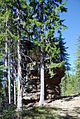
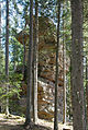
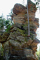
The name " furnace " comes from the language used in the area and highlights the distinctive, unusual shape of the rock: The Schrattelofen is a free-standing, approximately 9 m long, 5 m wide and 14 m high pile of rock slabs ( "Plattengneis " ). As with other striking rock formations in the Koralpe, its formation is attributed to the varying degrees of weathering of the rock layers.
The Schrattelofen is located on the southern slope of the Reinischkogel at an altitude of 1130 m, about 5 minutes' walk from the vlg farm . Großannerl on a forest path that branches off from the state road L 645 (Sallegger Straße) at the Reinischwirt, belongs to hiking trail 569 and leads to the Absetzwirt at Rosenkogel.
The natural monument is entered in the land register as "rock formation Schrattelofen" . An area of 2830 m² is protected around it. Protection is based on a decision from the Deutschlandsberg district administration. The protected area belongs to the basic areas of the farm vlg. Großannerl.

- Schrattelofen


Web links
- Schrattelofen , natural monument N6 at wanderfreund.at
Individual evidence
- ^ Curt Fossel, Hermann Kühnert: Natural history features in Styrian communities. Edited by Österreichischer Naturschutzbund, Landesgruppe Steiermark. Leopold Stocker Verlag, Graz-Stuttgart 1994. ISBN 3-7020-0692-3 . Page 231.
- ↑ Hans Peter Cornelius: On the interpretation of the "stone ovens" of the Kor and Saualpen area (Styria-Carinthia). In: Reports of the Geologische Reichsanstalt Wien, 1943. Pages 49–52.
- ^ Decision of the District Commission of Deutschlandsberg of February 27, 1978, reference number 6 J 1/77. Object no. 411, in: Digitaler Atlas Steiermark ( page no longer available , search in web archives ) Info: The link was automatically marked as defective. Please check the link according to the instructions and then remove this notice. Map service: flora & fauna, natural protected areas, natural monuments - if you hold down the right mouse button, enlarge the area by dragging. The information can be called up with "Identify object" (button "i"), and in the window that opens, look for "Natural monuments". Retrieved March 5, 2011.
- ↑ Land register district court Stainz, cadastral community 61235 Sallegg, deposit number 17, plots number 90 and 78.
Coordinates: 46 ° 54 ′ 18 ″ N , 15 ° 7 ′ 41 ″ E