
Ožbalt

Ožbalt (German St. Oswald im Drauwald, St. Oswald an der Drau ) is a place in northern Slovenia .
geography
Ožbalt is located at 306 m above sea level in the valley of the Drava . It belongs to the municipality of Podvelka ( Podwölling ) in the Štajerska region . The place is on the left bank (north bank) of the Drava at the mouth of the Ožbaltski potok ( Oswaldbach or Oswaldgrabenbach ) coming from the north, from the area of Kapla ( Kappel ) on the road between Maribor and Carinthia . In the south lies the wooded area of Pohorje . To the east of the village, another stream also runs from the Drautal to the north. The Črmenica flows in it.
history
The area of Ožbalt lies in the Drauwald, the border area between the historical Lower Carinthia ( Carantania , Duchy of Carinthia , County Jauntal ) and the Mark an der Drau ("Mark behind the Drauwald", seen from Carinthia). This mark was connected to the Mark an der Mur after 1147 , making it part of the core area of Styria in the Middle Ages . The course of the waters Velka ( Wölka ) - Drava – Črmenica ( Tschermenitzen -Graben east of Ožbalt) is assumed to be the boundary line in the Drava Forest . Before the merger of the market areas, the Ožbalt area was the easternmost part of what was then Lower Carinthia. There is no evidence of whether a settlement already existed at this time. Ožbalt was first mentioned in 1372.
According to the quarter division of Styria in 1462 , Ožbalt was in the "quarter between Mur and Traa" (Drava). In the 15th and 16th centuries, Ožbalt was in the area of the Mahrenberg and Remschnig regional courts. It belonged to the district of the branch church “Sant Osswaldt bey der Traa” of the parish “Our Frawen zw Fresen”.
From 1770, when people and houses were first recorded in Austria , houses and people from Ožbalt are recorded in the numbering section at the western town of Brezno . Together with the other numbering sections in Mahrenberg and Remschnig, the Ožbalt area initially belonged to the Faal advertising district (today Fala ) and later to the Mahrenberg advertising district (today Muta ) in the Marburg district . The Ožbalt area only became an independent parish in 1787.

Until 1818/19, the "small Velka" and the "Sturmrieden", rock slabs in the Drava near Ožbalt, were obstacles for the Drau navigation. They were removed along with other obstacles.
The ditch in which the Oswaldbach flows is called Oswaldgraben in older maps (not to be confused with the cadastral municipality of the same name “Oswaldgraben” near Kainach ), the course of the Črmenica was previously recorded as the Tschermenitza-Graben. Ožbalt has been a post office since the 19th century. In 1822 there was a trivial school with 17 children. At that time, the Oswaldgrabenbach drove a mill from which foreign grain was milled for a fee (toll mill), a rammer and two saws .
When the municipalities were reorganized in 1850, the existing municipality (cadastral municipality) Ožbalt was included in the new local municipality of Fresen. The place belonged to the district of the district court and tax office Mahrenberg in the district administration Windischgratz . At that time Ožbalt had 229 inhabitants (souls). St. Oswald remained the parish. Ožbalt covered 1465 yoke 683 square fathoms (= 843.3 hectares ) and was 11¼ hours from the seat of the district administration and 4¼ hours from the seat of the district court (footpath or ox cart).
Ožbalt was a mining town: in the northwest on the road towards Kappel there is a lead deposit, until 1855 a lead smelter was operated. An ore mine was located at the Divjakhube near Offberg in Remschnigg. Quartz veins , galena , copper pebbles , zinc blende and iron spar were found in the mica slate of the municipality , which were smelted in the municipality until 1840.
In Ožbalt there was a toll station on the Drauwalder (Carinthian) Reichsstraße. In 1898 this toll booth was relocated to Wurmath, but in 1900 it was relocated back to house no. 21 in what was then St. Oswald.
At the end of August 1944, an action by Yugoslav partisans began at the railway station in Ožbalt , during which 132 prisoners of war of the Allied armies of the Second World War were freed from the workforce of a labor camp of the German Reich. These prisoners were used to repair the railway line damaged by the partisans and were transported by train from a camp near Marburg. In the English-speaking world, this action is known as the "Raid at St. Lorenzen / Attack of St. Lorenzen". See the article on Wikipedia under web links. A memorial plaque on the road east of Ožbalt reminds of the Lackov Partisan Association crossing the Drava a few weeks later. This association was about 200-300 people strong and subsequently intervened in the districts of Leibnitz and Deutschlandsberg in Styria in the battles of the final phase of the Second World War .
Infrastructure
The Slovenian main road 1 "Mariborska cesta" (Marburger Strasse) leads in the Ožbalt area through the Drau valley. At Ožbalt, two roads branch off to the north. One from the center into the valley of the Ožbaltski potok (Oswaldbach), a second a few hundred meters east in the valley of the Črmenica stream. These connections lead over the area of Kappel and then over the Poßruck into southern Styria : either at Remšnik / Remschnigg (border crossing Arnfels / Kapla) to Arnfels or over border crossings at Gradišče / Schloßberg or Duh na Ostrem vrhu– ( Holy Spirit ) / Großwalz in the area of Schmirnberg Castle and Leutschach . These paths are not all passable by car; they are used by a number of hiking, mountain bike or cycling routes, such as B. from the Austria-Slovenija bike tour. Ožbalt is located on the Maribor↔ Radlje ob Dravi bus line and on the Maribor – Dravograd - Bleiburg - Klagenfurt railway line ( Drautalbahn , former route of the Southern Railway Company ). Around ten buses and four trains a day connect Ožbalt with Maribor . The train journey for the 28 km long route takes 40–50 minutes, to Prevalje and Holmec on the border with Austria (next Austrian station Bleiburg) the passenger train takes a little more than 1 hour for 47 km.

power plant
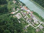
One kilometer east of Ožbalt there is a hydroelectric power station downstream on the Drava . This power plant was built between 1957 and 1960. After a renovation in the years up to 2005, it can produce energy with its three turbine sets with an output of up to 73 MW . The upper water (with filled reservoir) is at 299.22 meters above sea level, the underwater at 281.80 meters, resulting in a drop height results in a maximum of about 17 meters. The reservoir has a volume of 10.5 million m³, of which 1.4 million m³ can be used. It is 12.7 km long and extends to the power station at Vuhred ( Wuchern ) upstream .
Parish church
The name of the place and patron (patron saint) of the parish church is St. Oswald , an English king from the 7th century. St. Oswald applies u. A. as the patron saint of cattle, reapers and helpers against the plague. His veneration is associated with the “Schottenmission”, a wave of missions by Irish monks in southern Germany in the 12th and 13th centuries. The name Oswald is a combination of “ Odin ” and “walten” (rule), which is derived from Old High German , which is translated in a general sense as “ God rules”. Feast day of St. Oswald is August 5th.

The existing church was built from 1813 to 1817, its tower dates from 1859. A church in Ožbalt is mentioned as early as 1495 in the "Faaler Urbar". On August 21, 1510, the Lavantine bishop Leonhard Peurl consecrated an altar in this church to St. Andrew and St. Ursula with their companions ( Latin : "Vrsule et sodalium eius"). As relics of the altar , those of St. George as well as St. Mary and St. Hermagoras (referred to as "Hermachora") and Fortunatus were given in the consecration protocol in addition to those of the named ones . The parish belongs to the Mahrenberg deanery. The parish Kapla (Kappel) is also looked after from Ožbalt. This parish was established in 1893, before that from 1795 the church was a localie (chaplain) of Ožbalt. The parish of Ožbalt / St. Oswald can be confused with the parish (there called "Localie") of St. Oswald in Freiland due to the formulations of the older literature . In the 19th century the patronage of the parish was exercised by the religious fund. The church is registered in the Slovenian Cultural Property Register under the number 3216.
Web links
- Attack of St. Lorenzen : liberation of prisoners of war in 1944 by Yugoslav partisans (English Wikipedia, "Raid at St. Lorenzen").
- Overview (M443 Sv Ožbald, page in Slovenian.) To the cadastre sheets to St. Oswald in the Urmappe of the land registry in 1825 and in the rectificierten / reambulierten version 1840: Gray = forest, green = grass, scrub, W. = pasture, light yellow (In the leaves from 1825, the color of the paper is difficult to distinguish from the color of the paper) = Alpine pasture or less productive, darker yellow = arable land, brown = parcel of paths. Yellow buildings = wooden buildings, red buildings = stone buildings. JM = young maize, MH = medium wood, SH = pole wood, HS = high-stemmed, felling forest.
- Cadastral parish of St. Oswald 1825, northwest
- Cadastral parish St. Oswald 1825, northeast
- Cadastral parish of St. Oswald 1825, southwest
- Cadastral parish St. Oswald 1825, southeast, title page
- Ožbalt and the surrounding area
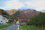
Center of Ožbalt

The road to Kapla branches off in the center of the village

Parish church

Ožbalt is located on the reservoir of the Ožbalt power plant

Drautal west of the village

The mouth of the Črmenica into the Drava: border point between Carantania and the Mark behind the Drava Forest in the early Middle Ages

A belt arch in front of the church apse documents the first mention of the settlement, parish elevation, church building and renovation

Power lines dominate the slopes above the village

The old bridge over the Ožbaltski Potok (Oswaldgrabenbach) remained when the main road was rebuilt as a house entrance
wooded, steep mountain slopes line the course of the Drava near Ožbalt

A Kaplan turbine is reminiscent of the renovation of the power plant near Ožbalt in 2004

Overview sheet for the original map of the Franziszeischen cadastre

Title page for the cadastral community of St. Oswald

"St. Osswald (Pf.) ” Around 1879 (top left), recording sheet of the state survey

After the end of Austria-Hungary , the continuation of this sheet of the geological map on a scale of 1: 75,000 was no longer possible, so that only the northern edge of the area around Ožbalt was geologically represented and the rest of the municipality area remained in the representation of the special map (center left)


Coordinates: 46 ° 35 ′ 2 " N , 15 ° 23 ′ 27.6" E
Individual evidence
- ↑ a b Geological map of Marburg 1: 75: 000 from 1930, see picture.
- ^ A b Rudolf Karl Höfer: The princely visitation of the parishes and monasteries in Styria in the years 1544/1545. Edition of the texts and representations on news about church life. Sources on the historical regional studies of Styria, published by the Historical Commission for Styria - HLK. XIV. Volume. Graz 1992. Self-published by the HLK. ISBN 3-901251-02-2 . Page 191.
- ^ Anton Mell, Hans Pirchegger: Styrian court descriptions . As sources for the Historical Atlas of the Austrian Alpine Countries. I. Department. District court map: Styria. In the series: Sources on the constitutional and administrative history of Styria. I. Volume. Published by the Historical State Commission for Styria. Graz 1914. Pages 376-380 .
- ^ Manfred Straka: Numbering sections and advertising districts of Styria 1779/81. Maps on a scale of 1: 300,000. In: Historical Atlas of Styria . Published by the Historical Commission for Styria - HLK. Academic printing and publishing company. Graz 1977 1st delivery: Administrative boundaries and population development in Styria 1770–1850. Sheets 2 (North sheet) and 3 (South sheet).
- ^ Manfred Straka: Tax communities and advertising districts of Styria 1798–1810. Maps on a scale of 1: 300,000. In: Historical Atlas of Styria . Published by the Historical Commission for Styria - HLK. Academic printing and publishing company. Graz 1977. 1st delivery: Administrative boundaries and population development in Styria 1770–1850. Sheets 4 (North sheet) and 5 (South sheet).
- ^ Straka: administrative boundaries . Pages 263-264.
- ^ Manfred Straka: cadastral communities and advertising districts of Styria 1818–1848. Maps on a scale of 1: 300,000. In: Historical Atlas of Styria . Published by the Historical Commission for Styria - HLK. Academic printing and publishing company. Graz 1977. 1st delivery: Administrative boundaries and population development in Styria 1770–1850. Sheets 6 (North sheet) and 7 (South sheet).
- ^ Johann Samuelersch, Johann Gottfried Gruber: General Encyclopedia of Sciences and Arts. Volume 1/27, page 354 and Volume 3/7, page 251.ersch -Gruber, Allg. Enzyklopädie, 1/27, page 354 in the Google book searcherschersch-Gruber, Allg. Encyclopedia, 3/7, page 251 in Google Book Search
- ^ A b Carl Schmutz: Steyermärkisches Lexicon - Historisch-topographisches Lexicon von Steyermark. Printed by Andreas Kienreich Gratz in 1822. Third part N – Se, page 87 Schmutz, hist.-topogr. Lexicon 1822 in the Google book search
- ↑ Part XXI of the Provincial Law and Government Gazette for the Crown Land of Styria. September 20, 1850. Supplement “Marburg District”, page 64 . List of the new municipalities in the Marburg district in Styria, Austria, that were created in 1850.
- ↑ Part XXI of the Provincial Law and Government Gazette for the Crown Land of Styria. September 20, 1850. Supplement “Marburg District”, page 65 . List of the new municipalities in the Marburg district in Styria, Austria, that were created in 1850.
- ^ Joseph Carl Hofmeister: The Carinthian Railway in Styria, historically described topographically, with an indication of the side routes. The newest wing runways of the Südbahn in Styria. II. West Parthie. Graz 1863. On commission from Georg Tarmon, Cilli. Page 22. Hofmeister, Kärntner-Bahn in the Google book search.
- ↑ a b Konrad Maritschnik : Land on the border. History, culture, adventure world; Südweststeiermark, Slovenia Gnas 1995 Verlag Weishaupt. ISBN 3-7059-0024-2 . Page 189.
- ^ Eduard Hatle: The minerals of the Duchy of Styria. Verlag Leuschner and Lubensky Graz 1885. Pages 24, 30 and 101. Hatle, Minerale in the Google book search.
- ↑ 1898 Announcement of the kk Finanz-Landes-Direktion für Steiermark from July 13, 1898 State Law and Ordinance Gazette for the Duchy of Styria from August 19, 1898, XXVII. Piece, No. 72, p. 104.
- ↑ 1898 Announcement of the kk Finanz-Landes-Direktion for Styria from March 7, 1900 , State Law and Ordinance Gazette for the Duchy of Styria from February 13, 1900, IX. Piece, No. 12, p. 25.
- ↑ Christian Fleck : Koralmpartisanen - About different careers of politically motivated resistance fighters. Ludwig Boltzmann Institute for Historical Social Science, materials on historical social science Volume 4. Verlag Böhlau. Vienna-Cologne 1986. ISBN 3-205-07078-X . Pages 76 and 293.
- ^ Christian Konrad. “In the struggle, you had equal rights…”: The armed resistance against National Socialism in Carinthia and Styria from a gender -historical perspective: Diploma thesis at the Karl-Franzens-Universität Graz, Institute for History. Graz 2010. Pages 13–15, 24.
- ^ Republika Slovenija. topografska karta 1: 50,000. list 9. Lovrenc na Pohorju. Geodetski Zavod Slovenije. Kartografski Oddelek 1996.
- ↑ Styrian wine country. Southwest Styria. Hiking, cycling and leisure map 1: 50,000. Freytag & berndt publishing house. Vienna. Duration 12/2011. ISBN 978-3-85084-321-8 . Description of the bike tour on page 28 of the booklet.
- ↑ Timetable of the Slovenian Railways .
- ↑ Dravske elektrarne Maribor (dem) : Ožbalt power plant: the more capable of the electric twins. The second power plant on the section of the Drava River between Vuzenica and Fala was built between 1957 and 1960 as the twin of the Vuhred HPP upstream. (accessed September 5, 2010)
- ↑ a b Ecumenical Lexicon of Saints and Oswald website ( Memento of the original from January 22, 2016 in the Internet Archive ) Info: The archive link was automatically inserted and not yet checked. Please check the original and archive link according to the instructions and then remove this notice. (queried September 15, 2010.)
- ^ Oskar Veselsky: The consecration reports from the ordination and consecration protocols of the bishops of Lavant in the 16th century. In: Sources for the historical regional studies of Styria, published by the Historical Commission for Styria - HLK, XI. Tape. Graz 1997. Self-published by HLK. No ISBN. Page 39.
- ↑ Schmutz, page 476. Schmutz, hist.-topogr. Lexicon 1822 in the Google book search.
- ^ Franz Raffelsperger (Ed.): General geographical lexicon of the Austrian imperial state. In an alphabetical order. According to all sources and the best patriotic relief organizations, from a society of geographers, postmen. Vienna 1847. In the main publishing house of the kkap typo-geographical art establishment Leopoldstadt Institute building no. 237. page 588. Raffelsperger, gen. Geogr. Lexicon 1847 in the Google book search. Also beforehand for dirt, page 87.
- ^ Dirt, page 357.
- ↑ Cultural property register .