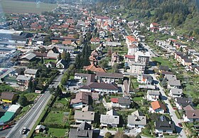
Radlje ob Dravi
|
Radlje ob Dravi Mahrenberg |
|||
|
|||
| Basic data | |||
|---|---|---|---|
| Country |
|
||
| Historic region | Lower Styria / Štajerska | ||
| Statistical region | Koroška (Slovenian Carinthia) | ||
| Coordinates | 46 ° 37 ' N , 15 ° 14' E | ||
| height | 370 m. i. J. | ||
| surface | 93.9 km² | ||
| Residents | 6,184 (January 1, 2017) | ||
| Population density | 66 inhabitants per km² | ||
| Telephone code | (+386) 2 | ||
| Post Code | 2360 | ||
| License Plate | SG | ||
| Structure and administration (status: 2002) | |||
| Mayor : | Alan Bukovnik ( ZLSD ) | ||
| Mailing address | Mariborska cesta 7 2360 Radlje ob Dravi |
||
| Website | |||
Radlje ob Dravi ( German : Mahrenberg , until 1952 Slovenian Marenberg ) is a Lower Styrian municipality that now belongs to the Koroška region in Slovenia .
geography
Radlje ob Dravi lies on the Drava and includes parts of Kozjak ( Possruck ) to the north and parts of Pohorje ( Bachern Mountains ) to the south . The Drau valley, which is very narrow over long stretches between Kozjak and Pohorje, widens in the Radlje area to a small plain called Radeljsko polje ( Mahrenberger Feld ).
There is a connection to Eibiswald and thus to Austria via the Radlpass ( Radelj ) .
According to the census from 1880, the residents of Mahrenberg only gave German as their colloquial language.
Community structure
The municipality comprises 14 localities, German place names in brackets (population figures as of January 1, 2017):
|
|
1 Some villages in the municipality had to temporarily change their names due to the 1948 Act on the Naming of Settlements, Squares, Roads and Buildings. The change was made in 1955 and affected Sveti Anton (then called Planina ), Sveti Trije Kralji ( Brezovec ) and Šent Janž ( Suhi Vrh pri Radljah ). However, all three got their old names back in 1993.
Neighboring communities
| Eibiswald ( A ) | Oberhaag ( A ) | |
| Muta |

|
Podvelka |
| Vuzenica | Ribnica na Pohorju |
history
The area around Radlje ob Dravi has been inhabited since ancient times. It is first mentioned as a settlement in 1139 and in 1268 it was granted market rights.
In 1900 the market town of Mahrenberg had 1,066 inhabitants, of which 971 were German and 59 Slovenian.
The place was formerly called Marenberg in Slovenian and was renamed Radlje ob Dravi in 1952. The basis for this was a law passed in 1948, the aim of which was to remove German parts of names from place and street names.
economy
Attractions
The former Dominican convent Mahrenberg, which was founded in 1251 by Seifried von Mahrenberg and his mother, stands on the mountain slope of the Kozjansko Hill . The Pavlijeva luknja and Huda luknja caves can be seen on Mount Perkolica.
Personalities
- Drago Grubelnik (1976-2015), ski racer
Web links

Individual evidence
- ↑ a b c Spremembe naselij 1948–95 . Geografski inštitut ZRC SAZU, DZS, Ljubljana 1996.
- ↑ Paul Hoffmann von Wellenhof: The struggle for Germanism, Vol. 8: Styria, Carinthia, Carniola and coastal land . JF Lehmann, Munich 1899, p. 95 ( archive.org [accessed March 7, 2019]).
- ^ General state law and government gazette for the Crown Land of Styria. 1850 (supplement Marburg district)
- ↑ Statistical Office of the Republic of Slovenia ( English )
- ^ KK Central Statistical Commission, Community encyclopedia of the kingdoms and countries represented in the Imperial Council. Edited on the basis of the results of the census of December 31, 1900. Volume IV Styria (Vienna 1904) p. 288.
- ↑ Mimi Urbanc, Matej Gabrovec (2005): Krajevna imena: poligon za dokazovanje moči in odraz local identitete . Geografski vestnik 77 (2), pp. 25-43.


