
Brezno (Podvelka)

Brezno (formerly Brezovo or Brezjo , German Fresen ) is a place in the valley of the Drava in the north of Slovenia .
geography
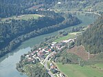
Brezno belongs to the municipality of Podvelka ( Podwölling ). It is located at 309 m above sea level on the north (left) bank of the Drava and has 429 inhabitants (2017), which makes the village the most populous place in the municipality. In this area, the Drava forms the reservoir of the Ožbalt hydropower plant east of Brezno .
The postcode of the place is 2363. For statistics, the place is added to the Koroška region .
The name "Fresen" is derived from the Slavic words * brěz'na, brěz'nik for birch , Birkenau, birch grove, birch forest .
history
The area of Brezno / Fresen lies in the Drauwald, the border area between the historical Lower Carinthia ( Carantania , Duchy of Carinthia , County of Jauntal ) and the Mark an der Drau ("Mark behind the Drauwald", seen from Carinthia). The Drava Forest was part of the Marcha orientalis , the border area between the areas of Eastern Franconia and the Holy Roman Empire in Carinthia and the areas of the Avars and Magyars / Hungarians in the Hungarian lowlands and their peripheral areas.
The course of the waters Velka ( Wölka ) - Drau – Črmenica ( Tschermenitzen -Graben near Ožbalt / St. Oswald im Drauwalde east of Brezno) is assumed to be the boundary line in the Drava Forest . The Mark an der Drau was connected to the Mark an der Mur after 1147 , making it part of the core area of Styria in the Middle Ages .

Brezno belonged to the manor of the Benedictine monastery of St. Paul since the 13th century by a decree of Bernhard von Spanheim .
The Brezno church was first mentioned in a document at the end of the 12th century. The connection with the Benedictine monastery is evidenced in the 21st century by the motto Ora et labora on the entrance gate to the Brezno churchyard. In the vicinity, in southern Styria, there are several places with the name part “Fresen”, for example near Schwanberg or in the former municipality of Wielfresen , which can lead to confusion in older documents.
After the quarter division of Styria in 1462 , Brezno belonged to the quarter between Mur and Traa (Drava). In the 15th and 16th centuries, Brezno was part of the Mahrenberg and Remschnig regional courts. In the 18th and 19th centuries, the area was in the Marburg district .
The place was the seat of the parish Our Frawen zw Fresen . Their spiritual feudal lord ( patron , patron) and secular bailiff was the abbot of St. Paul, to whom the residents had to provide services and taxes (including support for military equipment in the wars against the Turks ). In 1528 the parish was looked after by a pastor and a common priest. Confirmator ( firm donor ) was the Bishop of Lavant , to whose diocese the area belonged. According to the protocol of the princely visitation in 1528, which had taken place for the parish Fresen on June 23, 1528 in Windischgraz , the visit resulted in the fact that the illumination of the Eternal Light had not been done for "several weeks" and therefore ("twofold") to make up for it and that of the victims "the third tail should remain with the pharrer", no further comments. The number of people who had received communion could not be given because the pastor was ill. The following visitation in 1544/45 noted that the parish "Our women at Fresn bey der Traa" had about 100 people going to communion at that time. The presentation of priests from the diocese of Aquileia for the parishes of Fresen and Remschnigg on March 3, 1596 by the abbot of St. Paul and their confirmation by Bishop Georg Stobäus von Palmburg is evidence of the relationship between the diocese of Lavant and the Patriarchate of Aquileia . The presentation of a Benedictine monk is documented on February 4, 1666.
From 1770, when people and houses were first recorded in Austria , houses and people from Fresen were recorded in a separate numbering section . Together with the other numbering sections in Mahrenberg and Remschnigg, the Fresen area initially belonged to the Faal advertising district ( Slov. Fala), and from 1789 to the Mahrenberg advertising district in the Marburg district .
The area around Ožbalt including Kapla na Kozjaku (Upper and Lower Chapel) was detached from the Fresen parish in 1789. Kappel came to the parish Remschnigg (advertising district Arnfels in southern Styria). Ožbalt became an independent parish.
Until 1818/19, the "Kamm", a rock in the Drau near Fresen, was an obstacle for the Drauschiffahrt. It was then removed along with other obstacles.
After the reorganization of the municipalities in 1850, Fresen was merged with the previously independent municipalities Jaunegg and St. Oswald to form the new municipality of Fresen. The new community belonged to the district of the district court and tax office Mahrenberg in the district administration Windischgratz . At that time Fresen had 282, St. Oswald 229 and Jaunegg 246, the entire new community thus 757 inhabitants (souls). She remained the parish. The new Fresen comprised 3905 yoke 1402 square fathoms (= approx. 2250 hectares ), it was about ten hours from the seat of the district administration and three hours from the seat of the district court (footpath or ox cart).
Infrastructure
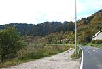
The Slovenian main road 1 Mariborska cesta (Marburger Strasse) leads in the Brezno area through the narrow Drau valley, bordered by steep slopes. At Brezno roads branch off to the north, into the valley of the Remšniški potok (Remschnikbach), the Bresniški potok (Fresenbach) and the Potočnikov potok . These connections lead to Sv. Juri (St. Georgen) and after Sv. Pankrac / St. Pongratzen on the border with Austria , then to the municipality of Oberhaag and Großradl in southern Styria . These connections are not all passable by car; they are used by hiking, mountain biking or cycling routes such as. B. the "Austria-Slovenija Tour" used. A road branches off south of Brezno into the Pohorje (Bachern) area, which leads via Ribnica na Pohorju (Reifnig am Bachern) to Slovenske Konjice (Gonobitz) or Slovenj Gradec (Windischgraz).
Brezno is on the Maribor↔ Radlje ob Dravi bus line and on the Maribor – Dravograd - Bleiburg - Klagenfurt railway line ( Drautalbahn , a former line of the southern railway company ). The railway station bears the name of the municipality Podvelka, in old maps it is registered as Reifnig-Fresen , after the place Ribnica na Pohorju south of Brezno in Pohorje. About ten buses and five trains a day connect Brezno with Maribor . The train journey for the 35 km long route takes about 55 minutes, to Prevalje and Holmec on the border with Austria (next Austrian station Bleiburg) the passenger train takes about an hour for 40 km.
Parish church
The church of "Holy Mary in the Fresen" was first mentioned in a document from 1161 to 1184. It is based on a Romanesque and early Gothic building , the tower was added in 1671. The interior is from the Baroque period . The church is registered in the Slovenian Cultural Property Register under no.2909.
- Brezno and the surrounding area
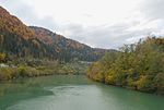
Drautal near Brezno from the bridge to the west
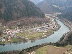
South-east of Brezno at the bend in the Drava
Brezno in the Drautal
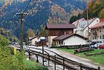
Podvelka station ( Reifnig-Fresen ): opened in 1863

Church of St. Maria in der Fresen
From Brezno to the west

Church complex from the east

West entrance from Brezno

Old gravestones in the nave wall of the church

Brezno churchyard

Fresen and its neighboring communities in the cadastre 1825

Settlement, street layout and agricultural areas in the south of Fresen 1825

Drautal from the bridge to the east

Fresen im Drautal around 1877/78 (right outside), recording sheet of the state survey

The east of the municipality of Fresen (Jaunegg and St. Oswald) around 1879 (far left)

Municipality area in the special map (far right), status 1926

The east of Fresen (far left)


Web links
- Overview Fresen (M443 Brezno, page in Slovene) in the cadastral sheets in the Urmappe the cadastre 1825 and reambulierten in rectificierten / Frame: Gray = forest, green = grass, scrub, W. = pasture, bright yellow (in the leaves of the year 1825 the hue is difficult to distinguish from the paper color) = alpine pasture or less productive, darker yellow = arable land, brown = path parcels. Yellow buildings = wooden buildings, red buildings = stone buildings. JM = young maize, MH = medium wood, SH = pole wood, HS = high-stemmed, felling forest.
- Cadastral municipality Fresen 1825, west, overview
- Cadastral municipality Fresen 1825, west, title page
- Cadastral municipality Fresen 1825, north
- Cadastral municipality Fresen 1825, south, town center (name with long s , no f)
Individual evidence
- ↑ a b Republika Slovenija. topografska karta 1: 50,000. list 9. Lovrenc na Pohorju. Geodetski Zavod Slovenije. Kartografski Oddelek 1996.
- ↑ Statistical Office of the Republic of Slovenia ( English )
- ↑ Manfred Trummer: Slavic Styria. Slightly extended version of the lecture of the same name at the symposium “Being foreign - staying together. The Slovene Ethnic Group in Austria ”as part of the“ Slovene Days ”at the Karl-Franzens University in Graz, March 25-28, 1996. In: Christian Stenner (ed.): Slovenian Styria. Displaced minority in Austria's southeast. Vienna-Cologne-Weimar Böhlau Verlag 1997. ISBN 3-205-98690-3 . Pages 15-34. ( Page no longer available , search in web archives ) Info: The link was automatically marked as defective. Please check the link according to the instructions and then remove this notice. ( MS Word ; 87 kB)
- ^ Hans-Dietrich Kahl: Slovenia and the neighboring countries between antiquity and the Carolingian era. Facts, theses and questions about the early formation of Slavic power in the Eastern Alps (7th – 9th centuries) ./ Slovenija in sosednje dežele med antiko in karolinško dobo: dejstva, teze in vprašanja o zgodnji slovanski državni tvorbi v vzhodnoalpskem prostoru (7th 9th stol.). In: Rajko Bratož: The State of the Carantans / Država Karantancev. In the row: Situla . Volume 39 Supplement [Volume 3]. ISSN 0583-4554 . Razprave Narodnega muzeja Slovenije. Ljubljana 2002. ISBN 961-6169-23-8 . (= Slovenska Akademija Znanosti in Umetnosti, Razred za Zgodovinske in Družbene Vede. Razprave / Dissertationes. Volume 20. ISSN 0560-2955 .) Pages 389, 417.
- ↑ Walther Fresacher (ed.): Austrian land register. Part 3: Arable spiritual manors. Volume 3: The medieval Stiftsurbare of Carinthia . Part II: The medieval land register of the Benedictine monastery of St. Paul in Carinthia 1289/90 and 1371/72. Austrian Academy of Sciences - OeAW. Vienna 1968. Verlag Böhlau Vienna-Graz-Cologne in commission of the Austrian Academy of Sciences. ISBN 978-3-7001-1492-5 (subsequently assigned ISBN, not generally applicable). Page xxii. Österr Urbare page xxii in the Google book search
- ^ Franz Raffelsperger (Ed.): General geographical lexicon of the Austrian imperial state. In an alphabetical order. According to all sources and the best patriotic relief organizations, from a society of geographers, postmen. Vienna 1847. In the main publishing house of the kkap typo-geographical art establishment Leopoldstadt Institute building no. 237. page 530. Raffelsperger, gen. Geogr. Lexicon 1847 in the Google book search
- ^ Rudolf Karl Höfer: The princely visitation of the parishes and monasteries in Styria in the years 1544/1545. Edition of the texts and representations on news about church life. In: Sources for the historical regional studies of Styria, published by the Historical Commission for Styria - HLK. XIV. Volume. Graz 1992. Self-published by the HLK. ISBN 3-901251-02-2 . Page 205 footnote 5.
- ^ Anton Mell, Hans Pirchegger: Styrian court descriptions . As sources for the Historical Atlas of the Austrian Alpine Countries. I. Department. District court map: Styria. In the series: Sources on the constitutional and administrative history of Styria. I. Volume. Published by the Historical State Commission for Styria. Graz 1914. Pages 376-380 .
- ↑ a b Höfer: Visitation 1544/1545. Pages 191.
- ↑ Höfer: Visitation 1544/1545. Pages 80, 83, 160, 165 and 191.
- ↑ Albrecher: Visitation 1528. Page 76.
- ^ Anton Albrecher: The princely visitation and inquisition of 1528 in Styria. Edition of the texts and presentation of the statements about the church conditions. In: Sources for the historical regional studies of Styria, published by the Historical Commission for Styria - HLK, XIII. Tape. Graz 1997. Self-published by HLK. ISBN 3-901251-10-3 . Page 235, on the date footnote 402.
- ↑ Albrecher: Visitation 1528. Page 414, footnote 1005 on the disease.
- ^ Oskar Veselsky: Lavanter ordination and consecration reports from 1586 to 1679. In: Sources for the historical regional studies of Styria, published by the Historical Commission for Styria - HLK, 22nd volume. Graz 2008. Self-published by the HLK. ISBN 978-3-901251-21-4 . Page 317.
- ↑ Veselsky, Ordination and Consecration Reports, p. 319.
- ^ Manfred Straka: Numbering sections and advertising districts of Styria 1779/81. Maps on a scale of 1: 300,000. In: Historical Atlas of Styria . Published by the Historical Commission for Styria - HLK. Academic printing and publishing company. Graz 1977 1st delivery: Administrative boundaries and population development in Styria 1770–1850. Sheets 2 (North sheet) and 3 (South sheet).
- ^ Straka: Administrative Boundaries , page 264.
- ^ Manfred Straka: Tax communities and advertising districts of Styria 1798–1810. Maps on a scale of 1: 300,000. In: Historical Atlas of Styria . Published by the Historical Commission for Styria - HLK. Academic printing and publishing company. Graz 1977. 1st delivery: Administrative boundaries and population development in Styria 1770–1850. Sheets 4 (North sheet) and 5 (South sheet).
- ^ Straka: administrative boundaries . Pages 263-264.
- ^ Straka, administrative boundaries . Page 222.
- ^ Johann Samuelersch, Johann Gottfried Gruber: General Encyclopedia of Sciences and Arts. Volume 27, page 354.ersch -Gruber, Allg. Encyclopedia, 27, page 354 in Google Book Search
- ↑ (with misprint "Fesen") XXI piece of the state law and government gazette for the Crown Land of Styria. September 20, 1850. Supplement “Marburg District”, page 64 . List of the new municipalities in the Marburg district in Styria, Austria, that were created in 1850.
- ↑ Part XXI of the Provincial Law and Government Gazette for the Crown Land of Styria. September 20, 1850. Supplement “Marburg District”, page 65 . List of the new municipalities in the Marburg district in Styria, Austria, that were created in 1850.
- ↑ Styrian wine country. Southwest Styria. Hiking, cycling and leisure map 1: 50,000. Freytag & berndt publishing house. Vienna. Duration 12/2011. ISBN 978-3-85084-321-8 . Description of the bike tour on page 28 of the booklet.
- ↑ Timetable of the Slovenian Railways .
- ^ Register of cultural property in Slovenia.
Coordinates: 46 ° 35 ′ 40 ″ N , 15 ° 19 ′ 6 ″ E