
Wielfresen

Wielfresen is a group in the village of Unterfresen in the municipality of Wies in western Styria . Until the end of 2014, Wielfresen was also a municipality with 577 inhabitants (as of 2014) in the Deutschlandsberg district in Styria . As part of the Styrian community structural reform , Wielfresen has been merged with the communities of Wies, Wernersdorf and Limberg bei Wies since 2015, and the new community continues to use the name Wies. The basis for this is the Styrian Municipal Structural Reform Act - StGsrG.
geography
The municipality of Wielfresen was located on the southeast slope of the Koralpe at an altitude of 400 to 2,000 meters. The main town is a Rotte, the associated town is called Unterfresen and is a scattered settlement with courtyards in some cases over 1,000 meters above sea level. The area is drained by the White Sulm and the numerous tributaries, which have excellent water quality. In terms of traffic, Wielfresen is opened up by the L 652 state road.
Cadastral communities are Unterfresen, Wiel-St. Oswald and Wiel-St. Anna. The town center with the office building, the farmyard and the volunteer fire brigade is located in Unterfresen.
Neighboring places
| Garanas |
Schwanberg / Limberg near Wies |
|
| Sankt Georgen im Lavanttal |
.svg)
|
Wies |
| Soboth | Sankt Oswald ob Eibiswald | Wernersdorf |
geology
Wielfresen lies in a terraced and step landscape with steep flanks and canyon-like erosion cuts. Crystalline slate, gneiss and mica slate with embedded eclogite rock bodies and quartz veins are predominant . The area is included in the Koralm-Kristall-Trail.
climate
Climatically, Wielfresen is shielded from the oceanic weather by the Koralpe towering to the west. The area is one of the weakest winds in Austria, but has large amounts of precipitation at high altitudes. The annual mean temperature is 1 degree in winter and 17 degrees in summer. At over 1,000 meters above sea level, the area is largely free of fog.
history
In the 6th century the area was populated by Slavs . With the influence of the Schwanberg domain around 1000, Bavarian settlement and Christianization began.
The first known mention of "Vrezen" and "Wiell" is documented in the Salzburg Chamber Book of 1430, but as early as 1236 the "perg Wroll" was mentioned in a deed of lease. In the offices of Fresen and Wiel there were at times over a hundred Huben. Today there are almost fifty farms.
Until 1849 the area belonged to the Schwanberg rule, with the lords of Pettau , the Spangsteiners , the Gallern, the Wagensbergers, the Counts of Saurau and the Princes von und zu Liechtenstein . In 1849 the KG Unterfresen, Wiel-St. Anna and Wiel-St. Oswald merged to form the local community of Wielfresen.

The primary school in the St. Katharina district, which looked after 65 school children in 1878, was closed in 2004. Your listed building was renovated and opened on December 4, 2011 as a communication center by Wielfresen. During the renovation, the building received a new clay roof, windows and other wooden parts were refurbished and a larch gable cladding was installed.

Culture and sights
See also: List of listed objects in Wies
- Mountain church St. Katharina, late 15th century, high altar from 1668, organ by C. Billich from 1876, tower clock by Master Berthold from 1896.
- Klementikapelle with altarpiece by Bruno Wildbacher.
- Schaumühle am Schwarzbach, 150 year old two-speed mill with a 3 meter water wheel, original restoration, ready for operation
- Hochstube, architectural feature.
- "G'fangener Russ", stone sculpture by Carl Hermann based on the poem by Hans Kloepfer
- New building chapel: This chapel was built around 1840 and renovated in 2010. It is consecrated to the Holy Virgin Mary.
Population development

Natural monuments
- Eclogite formation "Hollow Rocks" is the most beautiful formation of this rare rock in Austria.
- Waterfall in the White Sulm , cataract stages of 150 m in total, crags (rock mills), sulfur flowers .
Culinary specialties
- Wielfresner snack box, bucket meat, Schilcher , fine brandies, juices , soft fruit (Koch's berries)
politics
Municipal council until 2014
The municipal council last consisted of 9 members and, since the municipal council election in 2010, has consisted of mandates from the following parties:
- 5 WFW (WE FOR MILLING MACHINES) - Mayor Franz Jöbstl, Vzbgm. Helfried Gangl, Christiane Stopper, Franz Koch, Annemarie Roschitz
- 4 ÖVP - Treasurer Theresia Koch, Karl Freidl jun., Stefan Fürpass, Peter Golob
coat of arms
The municipal coat of arms was awarded with effect from July 1, 1979.

The coat of arms shows a red straightening wheel, broken in three parts, with eleven spokes as an attribute of Saint Catherine on a silvery background. Green birch twigs (Slav. Birch = Fresen) with three leaves at the top and five leaves at the bottom grow out of the breakpoints.
Honorary citizen
- 1959: Georg Tschuchnigg, former mayor
- 1963: Josef Krainer senior , Governor of Styria from 1948 to 1971
- 1979: Friedrich Niederl , Governor of Styria from 1971 to 1980
- 1983: Josef Krainer junior , Governor of Styria from 1980 to 1996
- 2004: Waltraud Klasnic , Governor of Styria from 1996 to 2005
- 2009: Hermann Schützenhöfer , Deputy Governor of Styria
literature
Erich Wozonig: Wielfresen - a mountain community on the eastern edge of the Koralpe . Homeland book and parish chronicle. Verlag Simadruck, Deutschlandsberg 2003. No ISBN. 354 pages.
Historical maps
- The area of Wielfresen in the three regional surveys in the period from approx. 1789 to 1910
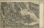
"Area Wielen" and "Area Fresen" in the Josephinische Landesaufnahme , around 1790 (bottom left)
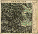
The area of Wielfresen in the Franziszeische Landesaufnahme , approx. 1835

Wielfresen reaches up to the height of the coral train (here southeast of the Koralpe as "Ge. Wiel")
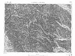
Oberfresen (lower edge of the card) in the Francisco-Josephine land survey , approx. 1910


Web links
- Statistical data on the former municipality (click on the individual lines on the linked page)
Individual evidence
- ^ Styrian municipal structural reform .
- ↑ Section 3, Paragraph 2, Item 6 of the Act of December 17, 2013 on the reorganization of the municipalities of the State of Styria ( Styrian Municipal Structural Reform Act - StGsrG). Provincial Law Gazette for Styria of April 2, 2014. No. 31, year 2014. ZDB -ID 705127-x . P. 2.
- ↑ Weekly newspaper Weststeirische Rundschau from December 9, 2011. 84th volume No. 49. Page 15.
- ↑ "G'fangener Russ" .
- ↑ Weekly newspaper Weststeirische Rundschau from June 10, 2011. 84th volume no. 23, page 1 (incorrectly referred to as no. 21 of May 27, 2011 on the front page).
- ↑ Communications from the Styrian State Archives 30, 1980, p. 47

Bad Schwanberg | Deutschlandsberg | Eibiswald | Frauental an der Laßnitz | Great Saint Florian | Lannach | Pölfing-Brunn | Preding | Sankt Josef (West Styria) | Sankt Martin im Sulmtal | Sankt Peter im Sulmtal | Sankt Stefan ob Stainz | Stainz | Wettmannstätten | Wies
93 Former communities (dissolved since 1945):
Aibl |
Aigen |
Bad Gams |
Blumegg |
Breitenbach in West Styria |
Dietmannsdorf im Sulmtal |
Ettendorf near Stainz |
Feisternitz |
Field tree |
Freidorf an der Laßnitz |
Open field near Deutschlandsberg |
Gamsgebirge |
Garanas |
Gasselsdorf |
Georgsberg |
Gersdorf |
Grafendorf near Stainz |
Graggerer |
Grass shoe |
Greisdorf |
Greith |
Gressenberg |
Großradl |
Grub near Groß Sankt Florian |
Grünau an der Laßnitz |
Gundersdorf |
Gussendorf |
Hasreith |
Herbersdorf |
Hollenegg |
Kleinradl |
Monastery |
Kornriegl |
Kothvogel |
Kraubath (West Styria) |
Krottendorf an der Laßnitz |
Kruckenberg |
Laaken |
Lasselsdorf |
Lebing |
Limberg near Wies |
Mainsdorf |
Marhof |
Mettersdorf |
Michlgleinz |
Nassau |
Neudorf near Stainz |
Neurath |
Niedergams |
Oberhart |
Upper Latin |
Oisnitz |
Osterwitz |
Otternitz |
Petzelsdorf in West Styria |
Pichling at Stainz |
Pirkhof |
Pitschgau |
Rassach |
Rossegg |
Rostock |
Red wine |
Sankt Oswald ob Eibiswald |
Sankt Ulrich in Greith |
Schönaich |
Sierling |
Soboth |
Stainztal |
Stable yard |
Stammeregg |
Sterglegg |
Sulmeck-Greith |
Sulz |
Sulz-Laufenegg |
Tanzelsdorf |
Teipl |
Tobis |
Tobisegg |
Trahütten |
Trough |
Unterbergla |
Vochera am Weinberg |
Vochera an der Laßnitz |
Front village |
Forest in West Styria |
Wernersdorf |
Wetzelsdorf in West Styria |
Wielfresen |
Wieselsdorf |
Torrent |
Wohlsdorf |
Zeierling |
Zirknitz