
Bad Schwanberg
|
market community Bad Schwanberg
|
||
|---|---|---|
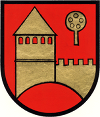
| coat of arms | Austria map | |
 |
|
|
| Basic data | ||
| Country: | Austria | |
| State : | Styria | |
| Political District : | Deutschlandsberg | |
| License plate : | DL | |
| Surface: | 124.19 km² | |
| Coordinates : | 46 ° 45 ' N , 15 ° 12' E | |
| Height : | 427 m above sea level A. | |
| Residents : | 4,559 (Jan 1, 2020) | |
| Postcodes : | 8530, 8541 | |
| Area code : | 03462, 03467 | |
| Community code : | 6 03 49 | |
| NUTS region | AT225 | |
| Address of the municipal administration: |
Hauptplatz 6 8530, 8541 Bad Schwanberg |
|
| Website: | ||
| politics | ||
| Mayor : | Karl Heinz Schuster ( ÖVP ) | |
|
Municipal Council : (2020) (21 members) |
||
| Location of Bad Schwanberg in the Deutschlandsberg district | ||
  |
||
 View of Bad Schwanberg from the Josefikirche |
||
| Source: Municipal data from Statistics Austria | ||


The market town of Bad Schwanberg (until March 2020 Schwanberg ) with 4559 inhabitants (as of January 1, 2020) is located in the Deutschlandsberg district in western Styria . As part of the Styrian municipal structural reform , it has been merged with the former municipalities of Hollenegg , Gressenberg and Garanas since the beginning of 2015 and continued the name Schwanberg until the end of 2019. The basis for this is the Styrian Municipal Structural Reform Act - StGsrG.
Bad Schwanberg is known as a health resort because of its mud baths , the entire community is a spa zone .
geography
The Bad Schwanberg market is located at the foot of the Koralpe at an altitude of 431 m in the valley of the black Sulm . It is located at the fork of two old streets across the Koralm, an old wine route (Kirchengasse) and the Garanasstrasse.
Community structure
The community consists of twelve cadastral communities and is divided into thirteen towns of the same name (area: as of December 31, 2018; inhabitants: as of January 1, 2020):
- Aichegg (282.09 ha; 420 Ew.) With the other districts Grünberg, Haderberg and Rettenberg
- Garanas (5,226.40 ha; 178 Ew.)
- Gressenberg (3,478.55 ha; 289 Ew.) With glassworks, Gressenberg Schattseite and Gressenberg Sonnseite
- Hohlbach (230.70 ha; 281 Ew.) With Riemerberg
- Hollenegg (232.01 ha; 211 Ew.)
- Kresbach (262.98 ha; 423 Ew.) With Eden
- Kruckenberg (in KG Neuberg; 51 Ew.) With Unterkruckenberg
- Mainsdorf (566.67 ha; 575 Ew.) With Großgraden, Kleingraden, Obermainsdorf, Schöglberg and Untermainsdorf
- Neuberg (319.12 ha with Kruckenberg; 193 Ew.) With Oberneuberg
- Oberfresen (757.17 ha; 75 Ew.) With Sankt Anna ob Schwanberg
- Rettenbach-Hollenegg (192.14 ha); Rettenbach (143 Ew.) With Kleinobl
- Schwanberg (637.51 ha; 1374 Ew.) With lower limestone pit
- Trag (239.23 ha; 346 Ew.) With Hoferberg
Incorporations
On January 1, 1969, the municipality of Mainsdorf was incorporated.
On January 1, 1975, the community of Kruckenberg was divided into the (now former) communities of Hollenegg and Trahütten .
The municipalities of Garanas , Gressenberg and Hollenegg followed on January 1, 2015 .
Neighboring communities
One of the five neighboring communities is in the Carinthian district of Wolfsberg (WO).
| Deutschlandsberg | Frauental on the Laßnitz | |
| Frantschach-Sankt Gertraud (WO) |
.svg)
|
Sankt Peter im Sulmtal |
| Wies |
history
Archaeological sites
In the east and south of Bad Schwanberg there are several archaeological sites that were found in the 19th century. have been thoroughly investigated. These are graves from Roman times and the following centuries, which - like the burial mound groups in the municipality of St. Martin im Sulmtal - prove that the area was settled.
Dance floor, front and rear tower: the area of the Altburg Schwanberg
At the "Tanzboden", the highest point of the Schwanberger Burgberg, was since the 10th century. a castle. It was removed around 1580 and the area leveled. The front tower, also called "Metnitzer Tower", was located on the site of the Josefikirche and was also part of this complex. Its remains were used as part of the church around 1685 and today form the choir in the eastern part of this church. A "rear tower" is on the one hand equated with Spangstein Castle , on the other hand it is assumed to be on the Amtmannhöhe west of the Altburg site. It is also believed to be at the fork in the road to the castle. No remains of it are recognizable. With the other building materials of the Altburg, today's Schwanberg Castle, which dates from the Renaissance period, was expanded.
During excavations from 2004 on, the remains of the old castle complex were found. With the remains of a ring wall and a round tower, the excavations revealed evidence of an impressive late medieval or early modern fortress. It remains to be seen whether this fortification could ever be completed. Evidence has also been found that the complex was built on the site of a much older castle. The results of the excavations from 2004 to 2012 will be processed in a dissertation at the Institute for Archeology at the University of Graz.
Market fortification Schwanberg
Remnants of the fortification of the Schwanberg market are in the east of the village in the area of today's Raiffeisengasse: There is a round tower (Rondell) with a diameter of 5.5 meters and a wall thickness of 90 cm. It is dated to the 15th century.
According to the quarter division of Styria in 1462, which was introduced by the Leibnitzer General Parliament for military and financial reasons , Schwanberg, like all of western Styria, was located in the "quarter this half of the Piberalm": That was the area south of the Gleinalm and west of the Mur to the Drau , es was also called the "quarter between Mur and Drava". Its main town was initially Leibnitz, later Marburg .
Peuerlhof
In the northeast of the village is the area of the former Peuerlhof. This courtyard dates back to the 12th century and consisted of a square building protected by a wall and a moat. The Peuerlhof is also referred to as “Hof zu Trag”, “Bäudlhof”, “Peierlhof”, old “Beutelhof”, it was a fiefdom of the Pettauer , its origins from the Eppensteiners and Wildoners are considered likely. Its owners were wealthy in the area; in the 14th century they were also administrators and burgraves of various castles in the Lavant valley . The later Bishop of Lavant Leonhard Peurl comes from the Peuerlhof. When Andreas Baumkircher moved towards Schwanberg in 1470 , the farm is said to have been completely burned down, but it was quickly rebuilt and lent again in 1477. The development of the property is documented in detail, including its furnishings: for the armory of the Peuerlhof, 1618 a. a. 18 muskets , 103 “common reeds” and 40 skewers and halberds mentioned. In 1622 the property was acquired by Christof von Galler and connected to the Schwanberg rulership, although a separate castle keep is documented in 1653 . This is the end of the independent history of what was then known as the “Gschloss Päuerlhof”. In the 18th century, their land was distributed to farms, and the complete demolition is assumed for the beginning of the 19th century. The building material was used for other buildings as in similar systems. There were different views on the location of the Peuerlhof: In Robert Baravalle's publications its location on the steep slope of the Stullneggbach is assumed, but later it was proven that the farm was not on the road to Hollenegg , but on the road to Mainsdorf, about 300 steps south of the Anne Chapel. Only unevenness in the floor can be seen from the complex; when a house was built in 1961, castle walls are said to have been exposed.
Almkrieg
During the Middle Ages, the border between the rule of Schwanberg, which had been awarded to the Lords of Pettau by the diocese of Brixen , and that of Deutschlandsberg was unclear, which repeatedly led to disputes. One of the most protracted disputes of this kind, the so-called “Almkrieg”, broke out at the beginning of the 14th century. It lasted around two decades and claimed numerous lives on both sides. While this dispute was essentially limited to the alpine pastures around Schwanberg and Deutschlandsberg, the Baumkircher feud in the second half of the 15th century also seriously affected the Schwanberg market and its surrounding area. Both imperial mercenaries and Baumkircher's mercenaries plundered and pillaged in and around Schwanberg.
Amthof
The Amthof von Schwanberg was on the site of the later Capuchin monastery. Its establishment is dated to the 14th century, in the 16th century the evangelical collegiate school, which was expelled from Graz, was housed. In 1681 the Amthof burned down, in 1706 its previously deserted area was given to the Capuchins, who used it to build the monastery.
Visitations 1529, 1544/45
The sovereign's visitation in 1529, which for the parish on 19 and 20 June 1529 in Stainz took place, called as pastor Niclas Graff, of the parish with two Gsell priests and a benefice care of and disputes over taxes with the Spang Steinem, the then rule Schwanberg owned, indicates. The number of communion visitors is given as 700. The visitation in 1544/45 dealt with the parish under “Pharr Sant Johans des Gottsthauffers zu Schwamberg”: The feudal lord was the Roman imperial majesty, who however received the parish of St. Andrä near Graz in 1479 through an exchange with the bishop of Seckau and is now the bishop feudal lord. The Bishop of Lavant is named as the confirmator (firm donor) . As before, around 700 people are given as “Comunicanten”. "Sant Anna" (Unterfresen, called 1498) is listed as a branch.
18th and 19th centuries
From 1748 onwards, Schwanberg and its surroundings were part of the then newly established Marburg district of the Duchy of Styria. From 1770, when people and houses were recorded in Austria for the first time , houses and people from the Schwanberg area were recorded independently in numbering sections ( conscription communities ). These sections were Wiel (St. Anna), Fresen, Garanas , Gressenberg , Rostock, Mainsdorf, Schwanberg and Kerschbaum. From these sections the “tax communities” developed under Joseph II , and subsequently the cadastral communities of the Franziszeische cadastre .
The numbering sections have been grouped into advertising districts (derived from recruiting people for military service). Schwanberg was such an advertising district. After 1826 the Hollenegg advertising district also joined him. The affiliation of the numbering sections to the advertising districts changed several times. The Schwanberg advertising district comprised 3702 people (souls) and 7 numbering sections (another partially) in 1770, 3362 people in 1782, 2259 people in 1812 (2276 according to another source) and ten cadastral communities with 3173 people in 1846. Neighboring advertising districts were Landsberg, Hollenegg, Eibiswald and Welsbergl.
20th century
A narrow-gauge industrial railway ran from Schwanberg station to the coal mines in Kalkgrub in the south of the village, in the Limberg district of the Wies community (until 2015 Limberg community). This railway was the first route on which standard-gauge freight wagons were transported on trolleys .
During the National Socialist July coup in 1934, the gendarmerie post in the market, to which members of the military organizations on the side of the government had fled, was literally besieged by a 200 to 300-strong National Socialist-minded mob. Previously, in the early evening hours, there had been several exchanges of fire in the market area, with the son of the National Socialist local group leader being shot by a member of the military association. In the morning of July 26, 1934, the National Socialists finally forced the surrender of the gendarmerie post. After the collapse of the coup, 74 people were arrested for participating in it, and an unknown number of others fled to the German Reich via Yugoslavia.
Population development
Population development in the community of Bad Schwanberg

Culture and sights


- Schwanberg Castle : Schwanberg Castle is located on a mountain to the west far above the town. The so-called “first castle”, built by the Pettau family in the 11th and 12th centuries , was destroyed in 1269 on the orders of the Bohemian King Ottokar . A few years later the reconstruction of the castle began by the Pettauer (12th to 14th centuries). The castle was completed in its current form in 1581. From the 14th century until the 17th century who ruled Galler then that Saurauer (among them Franz Josef Graf Saurau ) by the year 1822. The castle and lands were on the property of Liechtenstein , of which there are 1891 the country Styria bought . From 1892 to July 2015 the building served as a nursing home for the chronically ill.
- Hollenegg Castle with the Hollenegg parish church in the middle of the second courtyard is located in the Hollenegg district of the same name ; its location is already documented by a tower castle from the Middle Ages.
- Schwanberg parish church : The parish church in Bad Schwanberg was originally a chapel, but when Schwanberg was raised to parish in 1244, it became a parish church, the core of which has been preserved in Romanesque style. The builders of the church were the lords of Spangstein .
- Josefikirche Schwanberg : Maria Theresa declared St. Joseph to be the patron saint of Styria and Tyrol in 1771. A large number of places of worship and pilgrimage churches arose dedicated to the saint. The only remaining pilgrimage church of this kind is the Josefikirche in Bad Schwanberg. After the Second World War , the Josefikirche was in a threatening state of construction. Pastor Alois Polaschek had set himself the goal of preserving the Josefikirche for posterity. In order to create a reference to the present, the interior should be frescoed. In 1957, the artist Jakob Laub was commissioned to paint the St. Joseph's Church with frescoes depicting salvation history. With longer interruptions, the frescoes were completed in 1960 (vaults) and 1981 (side walls), but only completely in 1995, under six years of spiritual and material supervision by the new pastor Anton Lierzer. The Josefikirche is a landmark of the place that can be seen from afar. There used to be a watchtower on the site, and the guards gave the alarm when the enemy approached. Including the remains of the tower, the church of "Saint Joseph" was later built. A way of the cross leads to the church above the village.
- Schwanberg Monastery Church : The monastery with monastery church was built by the Capuchins after they had been given the property with the fire ruins of a former collegiate school by the Graz governor, Count Falbenhaupt, in 1706. In 1968 the monastery was closed, in 1970 the order, including the property and the church, sold it to the Moorbadgesellschaft, which has been operating the Heilmoorbad Schwanberg since 1973 .
- Brendlhof: The Brendlhof, north of Bad Schwanberg, was a Protestant prayer house with an associated cemetery in the 17th century . In it there are exhibition rooms that u. a. a peasant museum included. In the south wing there is a valuable stucco ceiling with angel heads.
- Greißlermuseum: The private Greißlermuseum was created from the inventory of six small grocery stores. On an 800 m² exhibition area in the so-called “Rikerhof”, items from the retail trade and antiques from the past are exhibited and in some cases also sold.
- Lebensschmiede: In the “Lebensschmiede”, a 200 year old, originally restored property, local artists exhibit their work.
Nature and landscape protection areas
- Nature reserve : The area east of the Speikkogel with the Seekar and Bärental is a nature reserve. The protected area includes the source areas of the Seebach, Payerlbach, Karbach and the Schwarzen Sulm, in it is a distribution area of the Gießbach Gemswurz (Doronicum cataractarum) , which occurs only on the Koralpe.
- Landscape protection area : Alpine areas on the eastern slope of the Koralpe (which partly also belong to the Seekar-Bärental nature reserve) in the west of Bad Schwanberg are protected as a landscape protection area (LSG-01). The protection brings about the preservation of the natural landscape elements and the preservation of the characteristics of the agriculturally shaped cultural landscape, in particular the preservation of landscape elements such as alpine mats, combat forest zones, rubble floors, crooked wood, natural flowing waters with their accompanying vegetation and habitats of wild animal and plant species.
Economy and Infrastructure
Tourism association
Together with St. Martin im Sulmtal and St. Peter im Sulmtal, the community forms the “Sulmtal-Koralm” tourism association. Its seat is in Bad Schwanberg.
health
- Heilmoorbad Schwanberg : The former Capuchin monastery has been used as a healing moor bath since 1973. The basis for the spa treatments, the products out of the bog of Garanas . The indications for a cure lie in all diseases of the rheumatic type .
education
- kindergarten
- Elementary school
- New middle school
politics

Municipal council
The municipal council consisted of 15 members until the end of 2014. After the municipal merger as part of the Styrian municipal structural reform , the municipal council consists of 21 members and consists of the following parties:
mayor
Until the municipal council elections in 2015, this function was administered by a government commissioner. This was the previous mayor of the market town, Mag. Karlheinz Schuster ( ÖVP ). Karlheinz Schuster was also elected mayor of the new municipality in the 2015 municipal council elections. His first deputy is Ing. Karl Leonhard Koch (ÖVP) and the second deputy is Harald Reiterer ( SPÖ ).
coat of arms
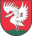
- Coats of arms of the previous municipalities

Garanas

Gressenberg
Hollenegg
Schwanberg


All four previous municipalities had a municipality coat of arms. Due to the amalgamation of municipalities, these lost their official validity on January 1st, 2015. The new awarding of the municipal coat of arms for the merged municipality has not yet taken place.
- Information on the coats of arms of the previous municipalities
- Garanas: During times of war in the Middle Ages , the path across the Koralpe was blocked off with wood and thorn bushes, which is why bushes are shown in the middle of the coat of arms. The place name "Garanas" comes from Old Slavonic and originally meant "hedge-enclosed, thorn-reinforced place". When the land was settled, the farmers had to uproot the birches , these bushes are shown in the upper and lower part of the coat of arms. Because the name Garanas is unique in Austria , three flowers have been added to the top of the thicket. The colors of the coat of arms symbolize the medieval landowners: the bishops of Salzburg and Brixen .
- Gressenberg: The coat of arms shows two golden glassmaker pipes crossed diagonally on top of each other on a blue shield . Three mountains protrude into the golden head of the shield, with a golden lily on the middle tip . The rest of the blue coat of arms is sprinkled with golden cress leaves . The municipal coat of arms was awarded with effect from October 1, 1989. The blazon read: "Two golden glassmaker's pipes crossed diagonally on a blue three-hill protruding into the golden head of the shield, the central tip of which is covered with a golden lily, but otherwise sprinkled with golden cress leaves."
- Hollenegg: The community emerged from the almost closed Hollenegg domain, the last of which was the ruling Prince of Lichtenstein . The colors of this house (gold-red), which were also the colors of Hollenegg, were appropriated by the community, and the castle, which is important in art history, became its symbol. The symbol, the so-called “Dalkenpan”, which was neither such nor a counting board, but rather an elderflower at the time when the Hollenegger's coat of arms was adopted, is supposed to allude to Hollenegg in a popular way, as it was once spoken.
- The municipal coat of arms was awarded with effect from July 1, 1979, the blazon (coat of arms description) read: “In the red shield on the red hill on the right, a golden round tower with two storeys divided by a pilaster, as well as a pointed roof and five arched, open windows in the upper one Half of the upper floor; A golden battlement wall, extending from the left edge of the shield, abuts the tower, which is raised by a golden pan pan. "
- Schwanberg: In 1243 a Heinrich and in 1255 a "Chunrad von Suanberch" was called. In their coat of arms they bore a "wild swan". The award of the coat of arms is not known in a document.
Personalities
Honorary citizen
- 1973: Friedrich Niederl (1920–2012), Governor of Styria 1971–1980
- 1985: Josef Krainer (1930–2016), Governor of Styria 1980–1996
- 1986: Franz Hasiba (* 1932), Provincial Councilor
- 2006: Otto Schenk (* 1930), actor, cabaret artist, director and artistic director.
Sons and daughters of the church
- Andreas Töpper (born November 10, 1786 in Schwanberg; † April 27, 1872 in Scheibbs), industrialist
- Ignaz Hofer (born June 15, 1790 in Schwanberg; † August 2, 1862 in Graz), painter and graphic artist
- Wilhelm Gericke (born May 18, 1845 in Schwanberg; † October 27, 1925 in Vienna), conductor in Vienna and Boston
- Georg Resch (born April 10, 1892 in Schwanberg; † November 7, 1952), politician of the ÖVP , member of the Styrian state parliament 1930–1934, 1945–1949, member of the Federal Council 1949–1952
Personalities associated with the community
- Samuel Leopold Schenk (born August 23, 1840 in Ürmény , † August 17, 1902 in Schwanberg), embryologist
- Ernst Mally (born October 11, 1879 in Krainburg , † March 8, 1944 in Schwanberg), philosopher
- Ludwig Mooslechner (born August 20, 1910 - April 10, 1945), doctor and resistance fighter against National Socialism
- Olga Neuwirth (born August 4, 1968 in Graz, grew up in Schwanberg), composer, musician, 2010: Austrian State Prize for Music
Historical maps
- The Schwanberg area in the regional surveys from approx. 1789 to 1910
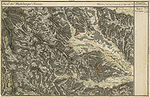
Schwanberg in the Josephinische Landesaufnahme , around 1790
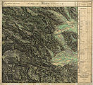
Schwanberg and Deutschlandsberg in the Franziszeische Landesaufnahme , approx. 1835

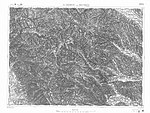
Schwanberg in the recording sheet 1: 25,000, around 1878
In the francisco-josephine land survey , approx. 1910


Web links
- 60331 - Bad Schwanberg. Community data, Statistics Austria .
- www.schwanberg.gv.at Official homepage of the market town of Bad Schwanberg
- Overview of the frescoed church interior of the Josefikirche ( memento from September 29, 2007 in the Internet Archive )
Individual evidence
- ↑ This is how the 15 communities in Deutschlandsberg voted. meinviertel.at , June 29, 2020, accessed on August 18, 2020 .
- ↑ City council election 2020 - results Bad Schwanberg. orf.at , accessed on August 18, 2020 .
- ↑ 22nd Announcement of the Styrian Provincial Government of March 11th, 2020 on the change of the municipality name of the market town "Schwanberg" in the political district Deutschlandsberg to "Bad Schwanberg" , ris.bka.gv.at
- ^ Styrian municipal structural reform .
- ↑ Section 3, Paragraph 2, Item 4 of the Act of December 17, 2013 on the reorganization of the municipalities of the State of Styria ( Styrian Municipal Reform Act - StGsrG). Provincial Law Gazette for Styria of April 2, 2014, No. 31, year 2014, ZDB -ID 705127-x , p. 2.
- ↑ Styria has two new health resorts orf.at, January 1, 2020, accessed on January 2, 2020.
- ↑ 12. Ordinance of the Styrian Provincial Government of February 6, 2020 on the establishment of the spa district "Bäderkurort Bad Schwanberg" , ris.bka.gv.at
- ^ A b c Kurt Woisetschläger, Peter Krenn: "Dehio Handbook - Austria's Art Monuments: Styria (excluding Graz)." Topographical Monuments Inventory, ed. from the Federal Monuments Office, Department for Monument Research. Verlag Anton Schroll, Vienna 1982, ISBN 3-7031-0532-1 , pp. 507-509.
- ↑ CSV file from REGIONALINFORMATION.zip (1,221 kB) ; accessed on January 12, 2019
- ↑ Statistics Austria: Population on January 1st, 2020 by locality (area status on January 1st, 2020) , ( CSV )
- ↑ Law of December 3, 1968 on territorial changes of municipalities , Provincial Law Gazette for Styria of December 27, 1968, Part 22, No. 164, p. 187.
-
↑ V (áclav, including: Wenzel) Radimský: "Prehistoric Research in the neighborhood of Wiesbaden in central Styria. I. The prehistoric monuments around Wies . “In: Franz Hauer (Red.): Communications of the Anthropological Society in Vienna - MAG. Volume XIII (Volume III of the new series); Born in 1883, ISSN 0373-5656 , ZDB -ID 206023-1 , Verlag Gerold, Vienna.
V (áclav, also: Wenzel) Radimský, Joseph Szombathy: "Prehistoric research in the area around Wies in Central Styria." III. Continuation of the report on the excavations in 1881, 1882 and 1883; Pp. 77–108, MAG XVIII (new part VIII), year 1888. - ↑ ( Page no longer available , search in web archives: Directory of Styria ), accessed on July 11, 2020.
- ↑ Werner Murgg, Bernhard Hebert: "Medieval and early modern fortifications in the Deutschlandsberg district: recording of the soil monuments." With drawings by Stefan Karl. "Contributions to Medieval Archeology in Austria BMÖ." Volume 10, year 1994. Ed .: Austrian Society for Medieval Archeology ÖGM, Vienna. ISSN 1011-0062 , ZDB -ID 805848-9 , p. 65, sketch of the location p. 91. Coordinates of the Altburg Schwanberg: 46 ° 45 ′ 18 ″ N , 15 ° 11 ′ 35 ″ E
- ↑ Werner Murgg, Bernhard Hebert: "Wehrbauten" pp. 65–66. Metnitzer coordinates of the tower: 46 ° 45 '19 " N , 15 ° 11' 48" O .
- ↑ Robert Baravalle: “Castles and Palaces of Styria. An encyclopedic collection of the Styrian fortifications and properties, which were endowed with the most varied of privileges. ”Graz 1961, Verlag Stiasny, p. 82.
- ↑ Werner Murgg, Bernhard Hebert, "Military architecture" 66. coordinates of the rear tower, Amtmann height: 46 ° 45 '39 " N , 15 ° 10' 44" O .
- ↑ Werner Murgg, Bernhard Hebert, "Military architecture" 66. coordinates of the rear tower, road junction: 46 ° 45 '30 " N , 15 ° 11' 13" O .
- ↑ Weekly newspaper “Weststeirische Rundschau” from September 17, 2010, Volume 83, No. 37, ZDB -ID 2303595-X , p. 1.
- ↑ General information on Altburg Schwanberg ( memento from November 29, 2014 in the Internet Archive ), accessed on September 21, 2010.
- ↑ Bernhard Schretter: "Fundbericht." Bundesdenkmalamt (Ed.): "Fundberichte aus Österreich." (FÖ) Volume 50, year 2011, Vienna 2012, ISSN 0429-8926 , ZDB -ID 213982-0 , pp. 392–394.
- ^ Current dissertations ( Memento of March 4, 2016 in the Internet Archive ): Sarah Kiszter: "The archaeological investigations of the Altburg Schwanberg-Tanzboden (district Deutschlandsberg, Styria) from 2004 to 2012"; accessed on August 13, 2015.
- ↑ Werner Murgg, Bernhard Hebert, "Military architecture" page 66, sketch map 92. coordinates of Schwanberger Rondells: 46 ° 45 '28 " N , 15 ° 12' 3" O .
- ↑ position after Murgg, Hebert, fortifications : 46 ° 45 '38 " N , 15 ° 12' 2" O .
- ↑ a b Robert Baravalle: "Castles and Palaces of Styria." P. 80.
- ↑ a b Werner Murgg, Bernhard Hebert: "Wehrbauten." P. 68.
- ^ "District topography": Helmut-Theobald Müller (ed.), Gernot Peter Obersteiner (overall scientific management): "History and topography of the Deutschlandsberg district." Graz-Deutschlandsberg 2005, ISBN 3-90193815X , Steiermärkisches Landesarchiv und Bezirkshauptmannschaft Deutschlandsberg 2005, In der Series: “Great historical regional studies of Styria. Founded by Fritz Posch † ”. First volume, general part. Gernot Obersteiner: "Settlement, administration and jurisdiction until 1848." ZDB -ID 568794-9 , p. 58.
- ^ Robert Baravalle: "Castles and Palaces of Styria." P. 79–80.
- ↑ Werner Tscherne: “From Lonsperch to Deutschlandsberg.” Self-published by the Stadtgemeinde Deutschlandsberg, undated (1990), p. 60.
- ↑ Anton Albrecher: “The princely visitation and inquisition of 1528 in Styria. Edition of the texts and presentation of the statements about the ecclesiastical conditions. ”In: Sources for the historical regional studies of Styria, published by the Historical Commission for Styria - HLK, XIII. Volume, Graz 1997, self-published by HLK, ISBN 3-901251-10-3 , ZDB -ID 559606-3 , pp. 76, 127, 230, 368 and 414.
- ^ Rudolf Karl Höfer: “The princely visitation of the parishes and monasteries in Styria in the years 1544/1545. Edition of the texts and presentations on news about church life. ”Sources on the historical regional studies of Styria, published by the Historical Commission for Styria - HLK. Volume XIV, Graz 1992, self-published by the HLK, ISBN 3-901251-02-2 , ZDB -ID 559606-3 , pp. 192-193.
- ↑ Manfred Straka: "Administrative boundaries and population development in Styria 1770-1850. Explanations for the first delivery of the Historical Atlas of Styria. “Research on the historical regional studies of Styria, XXXI. Volume, published by the Historical Commission for Styria - HLK. Self-published by HLK. Graz 1978, ZDB -ID 501108-5 , p. 91.
- ^ Karl Schmutz: "Historisch-topographisches Lexicon von Steyermark." Quoted from Straka, "Verwaltungsgrenzen", p. 215.
- ↑ Straka: "Verwaltungsgrenzen." Pp. 213–224.
- ^ Walter Krobot, Josef Otto Slezak, Hans Sternhart: “Narrow gauge through Austria. History and fleet of narrow-gauge railways in Austria from 1825 to 1975. “Verlag Slezak, 3rd edition, Vienna 1984, ISBN 3-85416-095-X , pp. 132-133.
- ↑ Gerald M. Wolf: "Now we are the gentlemen ..." The NSDAP in the Deutschlandsberg district and the July Putsch 1934 (Grazer Zeitgeschichtliche Studien, Volume 3) StudienVerlag, Innsbruck-Vienna-Bozen 2008, ZDB -ID 2261424-2 , p 165–157, 183 (list of the dead) and 186, ISBN 978-3-7065-4006-3 .
- ↑ Schwanberg: An era came to an end. Weekly newspaper "Weststeirische Rundschau" from July 10, 2015, 88th volume, No. 28, p. 1.
- ↑ coordinates of Brendlhofes: 46 ° 45 '34 " N , 15 ° 11' 49" O .
- ↑ Seekar-Bärental Nature Reserve , accessed June 30, 2015.
- ↑ Ordinance of the Styrian state government of June 11, 2015 on the declaration of areas of the Koralpe as landscape protection area No. 1, Styrian State Law Gazette No. 43/2015, June 15, 2015.
- ↑ Grazer Zeitung , Official Gazette for Styria, December 30, 2014, 210th volume, 52nd issue, ZDB -ID 1291268-2 , p. 631.
- ↑ http://www.heilmoorbad.at/ Homepage of the Heilmoorbad Schwanberg
- ↑ Elections. Retrieved January 28, 2020 .
- ↑ Municipal Council. In: www.schwanberg.gv.at. Retrieved October 11, 2016 .
- ↑ Communications from the Styrian State Archives 40, 1990, p. 33.
- ↑ Communications from the Styrian State Archives 30, 1980, p. 33
- ↑ Weststeirische Rundschau (June 30, 1973), p. 3.
- ↑ Weststeirische Rundschau, No. 6 (Feb. 9, 1985), p. 4.
- ↑ Südost-Tagespost (September 2, 1986), p. 10.
- ↑ Weststeirische Rundschau, No. 24 (June 12, 2020), p. 1.
- ↑ Biography of Olga Neuwirth . That she was “born” from Schwanberg (as mentioned in the weekly magazine “Weststeirische Rundschau” of February 5, 2010, 83rd year, No. 5, p. 1) cannot be confirmed from other sources.

Bad Schwanberg | Deutschlandsberg | Eibiswald | Frauental an der Laßnitz | Great Saint Florian | Lannach | Pölfing-Brunn | Preding | Sankt Josef (West Styria) | Sankt Martin im Sulmtal | Sankt Peter im Sulmtal | Sankt Stefan ob Stainz | Stainz | Wettmannstätten | Wies
93 Former communities (dissolved since 1945):
Aibl |
Aigen |
Bad Gams |
Blumegg |
Breitenbach in West Styria |
Dietmannsdorf im Sulmtal |
Ettendorf near Stainz |
Feisternitz |
Field tree |
Freidorf an der Laßnitz |
Open field near Deutschlandsberg |
Gamsgebirge |
Garanas |
Gasselsdorf |
Georgsberg |
Gersdorf |
Grafendorf near Stainz |
Graggerer |
Grass shoe |
Greisdorf |
Greith |
Gressenberg |
Großradl |
Grub near Groß Sankt Florian |
Grünau an der Laßnitz |
Gundersdorf |
Gussendorf |
Hasreith |
Herbersdorf |
Hollenegg |
Kleinradl |
Monastery |
Kornriegl |
Kothvogel |
Kraubath (West Styria) |
Krottendorf an der Laßnitz |
Kruckenberg |
Laaken |
Lasselsdorf |
Lebing |
Limberg near Wies |
Mainsdorf |
Marhof |
Mettersdorf |
Michlgleinz |
Nassau |
Neudorf near Stainz |
Neurath |
Niedergams |
Oberhart |
Upper Latin |
Oisnitz |
Osterwitz |
Otternitz |
Petzelsdorf in West Styria |
Pichling at Stainz |
Pirkhof |
Pitschgau |
Rassach |
Rossegg |
Rostock |
Red wine |
Sankt Oswald ob Eibiswald |
Sankt Ulrich in Greith |
Schönaich |
Sierling |
Soboth |
Stainztal |
Stable yard |
Stammeregg |
Sterglegg |
Sulmeck-Greith |
Sulz |
Sulz-Laufenegg |
Tanzelsdorf |
Teipl |
Tobis |
Tobisegg |
Trahütten |
Trough |
Unterbergla |
Vochera am Weinberg |
Vochera an der Laßnitz |
Front village |
Forest in West Styria |
Wernersdorf |
Wetzelsdorf in West Styria |
Wielfresen |
Wieselsdorf |
Torrent |
Wohlsdorf |
Zeierling |
Zirknitz