
Unterbergla

Unterbergla is an area in the south of Groß Sankt Florian in western Styria . Until the end of 2014, it was a municipality with 1,338 inhabitants (as of 2014) in the Deutschlandsberg district in Styria . Since January 1, 2015, Unterbergla has been merged with the municipality of Groß Sankt Florian as part of the Styrian municipal structural reform , the new municipality continues the name "Groß Sankt Florian".
geography
Unterbergla is located in western Styria in the central Laßnitz valley south of the Laßnitz river . Its area extends to the Gleinz ridge.
Neighboring places
| Great Saint Florian | Wettmannstätten | |
| Frauental on the Laßnitz |
.svg)
|
|
| Sankt Martin im Sulmtal | Gleinstätten | Sankt Andrä-Höch |
history
In Unterbergla there are a number of archaeological sites that document the settlement of the area at least since the Neolithic . Excavations in Grub and Unterbergla in 2008 revealed a layer of settlement from the Bronze Age and a house floor plan. Another reason for archaeological finds was the work on the oil and gas pipelines ( AWP and TAG ) that cross the municipality.
The name Hasreith is documented as Rasrewt in 1390 . The name is seen as a compound word, as a "Slavic-German mixed compound ". Its second syllable is derived from a clearing . Its first syllable is not traced back to rabbits , but to the Slavic word raz , which also denotes a (wood) cut, a clearing site.
The area of Unterbergla was part of the Mark an der Mur , which was separated into the heartland of Styria in 1122 and as the Duchy of Styria from Bavaria in 1180 . Before 1192 the area was ruled by the Otakare family, after which it belonged to the Babenbergs as Dukes of Styria , unless it was owned by the Prince Archbishopric of Salzburg , due to the inheritance rules of the Georgenberger Handfeste .
In the cadastral community Sulzhof , references to a building system from that time were found. In 1209 an Otto von Sulz is mentioned, in 1347 an Irg von Sulz . At the end of the 15th century the property belonged to the Lemsitzer family, then by marriage and inheritance to the Hollenegger and Galler families, who were also wealthy in the area. The court included subjects in the surrounding areas such as Waldschach, Petzelsdorf, Gleinz, Lassenbert, Obergreith, Dörfl and Hasreith. The Sulzhof was in the vicinity of the vlg. Schneiderhoisl on a small ridge near property no. 341/2 KG 61060 Sulzhof. This property is shown in the zoning plan as an archaeological site, but it is not listed in the compilations of the Federal Monuments Office on listed objects in Unterbergla . There is a 50 by 20 meter plateau on top of it, only stone blocks, traces of mortar and landforms are documented, which indicate a building complex, walls are no longer recognizable. In the years around 1711/12, the remains of the building are said to have been removed and used for the renovation of the church of Groß St. Florian.
From 1282 to 1918 the area was essentially under the rule of the Habsburgs , but from 1477 to 1490 it belonged to Matthias Corvinus' domain . Like many areas of Styria, it also suffered from the Ottoman raids in 1529 and 1532 .
In 1870 the name of the tax municipality Zelko, which belonged to the former municipality Sulzhof, was changed to Mönichgleinz , while the name of the settlement Zelko was retained.

On November 6, 1918 Unterbergla came to the Republic of German-Austria as part of Styria . After the annexation of Austria in 1938 he came to the Reichsgau Steiermark, from 1945 to 1955 he was part of the British zone of occupation in Austria .

The municipality of Unterbergla was created on January 1, 1968 by amalgamating the previously independent municipalities of Grub bei Groß Sankt Florian, Hasreith, Nassau, Sulzhof and part of the municipality of Michlgleinz (whose cadastral municipality of the same name) with the former municipality of Unterbergla. On June 1, 1951, the name of the municipality of Grub was changed to Grub near Groß Sankt Florian . The village of Langegg, which was still an independent municipality in 1868, also belongs to Grub.
Culture and sights
See also: List of listed objects in Groß Sankt Florian
coat of arms
The description of the coat of arms ( blazon ) reads: "In gold a blue carp decorated with gold grows from its dorsal fin a blue peacock wheel decorated with gold."
When designing the coat of arms of the municipality of Unterbergla, the coat of arms of the Gleinz family from the Gleinzer Bergland was taken as the starting point. They carried a so-called upper half peacock in a silver shield. Since the pond economy in the municipality goes back at least to the time of the beginnings of modern estate management (16th century) in the municipality and carp farming is still important today, the inclusion of carp in the coat of arms made sense. The color blue was chosen for the carp. The main color impression of a peacock is also blue. Since gold is a warm metal, equilibrium with the cold color blue has been achieved.
The seven peacock feathers represent the seven cadastral communities of Unterbergla. The way the peacock feathers grow from the dorsal fin or the caudal fin of the carp creates a close connection between the present and the past.
The award was made by ordinance of the Styrian state government with effect from June 1, 1988.
Population development
The number of inhabitants in the Unterbergla area has not changed significantly in the last 150 years, it is around 1400 people.

Economy and Infrastructure
Unterbergla has a predominantly rural structure, with the proportion of full-time farmers falling below 10%. The area is particularly known for the large number of ponds in which carp are mainly bred. This is also reflected on the coat of arms of Unterbergla, which shows a carp with peacock feathers. Originally a peacock was the municipality's heraldic animal.
politics
Municipal council
The municipal council last consisted of 15 members and, since the municipal council election in 2010, has consisted of mandates from the following parties:
mayor
Most recently, the mayor was Josef Aldrian from the ÖVP. Its vice mayor was Franz Jöbstl.
Personalities
Honorary citizen
- 1982: Josef Krainer (1930–2016), Governor of Styria 1980–1996
Sons and daughters of the church
- Peter Sengl (* 1945), painter
Michlgleinz cadastral community
Michlgleinz is a small village with 81 households. It is on the border with Wettmannstätten and Groß Sankt Florian and on the district border with Leibnitz . The center of the village is formed by the chapel, the fire station and the parish hall. The Michlgleinz cooling community is also located in the parish hall. The village offers many leisure activities: There is an outdoor swimming pool, a tennis facility (2 clay courts), a soccer field, a multi-purpose field for various events (approx. 1800 m²) and an inn (Pizzeria Stoiser). The local fire brigade, which provides fire protection and general help, has 122 members and is therefore the most powerful fire brigade in the district. The Michlgleinz volunteer fire brigade organizes a three-day tent festival every year.
Web links
- Statistical data on the former municipality (click on the individual lines on the linked page)
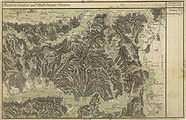
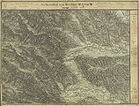
Historical maps
- Unterbergla and its surroundings in the regional recordings of the Austro-Hungarian monarchy
"Dorf Bergla" south of "Florian" in the Josephinische Landesaufnahme , approx. 1790

Hasreit municipality in the southwest of Unterbergla (top right)
Recording sheet with the west of the community, around 1878

The east of Unterbergla around 1878

Unterbergla in the special map , around 1910

Michelgleinz and Mönichgleinz in the east of Unterbergla


Individual evidence
- ^ Announcement by the Styrian state government of November 14, 2013 on the unification of the market community Groß Sankt Florian and the community Unterbergla, both political district of Deutschlandsberg. Styrian Provincial Law Gazette of December 2, 2013. No. 142, 34th issue. ZDB ID 705127-x . P. 672.
- ^ Find reports from Austria. Published by the Federal Monuments Office. Volume 47, year 2008. Vienna 2009. Page 541.
- ↑ Michael Brandl et al: Archaeological investigations on the Adria-Vienna pipeline in Laßnitztal, West Styria. In: Find reports from Austria. Volume 45, year 2006. Vienna 2007. Pages 257–280.
- ^ Fritz Lochner von Hüttenbach: The clearing names of Styria. In: Michaela Ofitsch, Christian Zinko: 125 years of Indo-European Studies in Graz. Festival tape on the occasion of the 125th anniversary of the research facility "Indo-European Studies" at the Karl-Franzens University Graz. Verlag Leykam, Graz 2000. ISBN 3-7011-0026-8 . P. 249.
- ^ Robert Baravalle: Castles and palaces of Styria. An encyclopaedic collection of the Styrian fortifications and properties, which were endowed with various privileges. Graz 1961, Stiasny publishing house. P. 86.
- ↑ Sulzhof Castle Unterbergla 46 ° 47 '24 " N , 15 ° 19' 53" E
- ↑ Digitaler Atlas Steiermark (GIS Steiermark) ( Memento of the original from June 15, 2012 in the Internet Archive ) Info: The archive link was inserted automatically and has not yet been checked. Please check the original and archive link according to the instructions and then remove this notice. , Map service: planning & cadastre, extensive visualization.
- ^ Sulzhof In: Werner Murgg, Bernhard Hebert: Medieval and early modern fortifications in the district of Deutschlandsberg: recording of the soil monuments. With drawings by Stefan Karl. Contributions to medieval archeology in Austria BMÖ. Volume 10, born in 1994. Ed .: Austrian Society for Medieval Archeology ÖGM, Vienna. ISSN 1011-0062 . P. 69.
- ^ Announcement by the head of the Imperial and Royal Lieutenancy for Styria dated February 26, 1870 , State Law and Ordinance Gazette for the Duchy of Styria dated April 14, 1870, IX. Piece, No. 22, p. 53.
- ↑ Law of December 18, 1967 on territorial changes of municipalities , Provincial Law Gazette for Styria of December 29, 1967, Part 26, No. 138, p. 188.
- ↑ Announcement of May 16, 1951 , State Law Gazette for Styria of December 28, 1959, Issue 13, No. 37, p. 114.
- ↑ Municipal directory of the district court of Deutsch-Landsberg 1868. From: Political division of the Duchy of Styria, announcement by the Imperial and Royal Governor of Styria on October 31, 1868, with which the detailed division overviews are brought to the attention of the political and judicial organization of the Duchy of Styria. State Law and Ordinance Gazette of the Duchy of Styria of April 21, 1869, XX. Piece, No. 36, p. 59 and appendix.
- ↑ Ordinance of April 25, 1988 , Styrian State Law Gazette No. 31, year 1988, 8th issue, issued June 1, 1988, page 40.
- ↑ Weststeirische Rundschau, No. 37 (September 18, 1982), p. 1.

Bad Schwanberg | Deutschlandsberg | Eibiswald | Frauental an der Laßnitz | Great Saint Florian | Lannach | Pölfing-Brunn | Preding | Sankt Josef (West Styria) | Sankt Martin im Sulmtal | Sankt Peter im Sulmtal | Sankt Stefan ob Stainz | Stainz | Wettmannstätten | Wies
93 Former communities (dissolved since 1945):
Aibl |
Aigen |
Bad Gams |
Blumegg |
Breitenbach in West Styria |
Dietmannsdorf im Sulmtal |
Ettendorf near Stainz |
Feisternitz |
Field tree |
Freidorf an der Laßnitz |
Open field near Deutschlandsberg |
Gamsgebirge |
Garanas |
Gasselsdorf |
Georgsberg |
Gersdorf |
Grafendorf near Stainz |
Graggerer |
Grass shoe |
Greisdorf |
Greith |
Gressenberg |
Großradl |
Grub near Groß Sankt Florian |
Grünau an der Laßnitz |
Gundersdorf |
Gussendorf |
Hasreith |
Herbersdorf |
Hollenegg |
Kleinradl |
Monastery |
Kornriegl |
Kothvogel |
Kraubath (West Styria) |
Krottendorf an der Laßnitz |
Kruckenberg |
Laaken |
Lasselsdorf |
Lebing |
Limberg near Wies |
Mainsdorf |
Marhof |
Mettersdorf |
Michlgleinz |
Nassau |
Neudorf near Stainz |
Neurath |
Niedergams |
Oberhart |
Upper Latin |
Oisnitz |
Osterwitz |
Otternitz |
Petzelsdorf in West Styria |
Pichling at Stainz |
Pirkhof |
Pitschgau |
Rassach |
Rossegg |
Rostock |
Red wine |
Sankt Oswald ob Eibiswald |
Sankt Ulrich in Greith |
Schönaich |
Sierling |
Soboth |
Stainztal |
Stable yard |
Stammeregg |
Sterglegg |
Sulmeck-Greith |
Sulz |
Sulz-Laufenegg |
Tanzelsdorf |
Teipl |
Tobis |
Tobisegg |
Trahütten |
Trough |
Unterbergla |
Vochera am Weinberg |
Vochera an der Laßnitz |
Front village |
Forest in West Styria |
Wernersdorf |
Wetzelsdorf in West Styria |
Wielfresen |
Wieselsdorf |
Torrent |
Wohlsdorf |
Zeierling |
Zirknitz