
Sankt Martin im Sulmtal
|
Sankt Martin im Sulmtal
|
||
|---|---|---|
| coat of arms | Austria map | |
 |
|
|
| Basic data | ||
| Country: | Austria | |
| State : | Styria | |
| Political District : | Deutschlandsberg | |
| License plate : | DL | |
| Main town : | Sulb | |
| Surface: | 39.18 km² | |
| Coordinates : | 46 ° 45 ′ N , 15 ° 18 ′ E | |
| Height : | 333 m above sea level A. | |
| Residents : | 3,105 (January 1, 2020) | |
| Postcodes : | 8543, 8443, 8522, 8542, 8544, 8551 | |
| Area code : | +43 3465, 3457 | |
| Community code : | 6 03 47 | |
| NUTS region | AT225 | |
| Address of the municipal administration: |
Sulb 72 8543 Sankt Martin im Sulmtal |
|
| Website: | ||
| politics | ||
| Mayor : | Franz Silly ( ÖVP ) | |
|
Municipal Council : (2020) (21 members) |
||
| Location of Sankt Martin im Sulmtal in the Deutschlandsberg district | ||
  |
||
| Source: Municipal data from Statistics Austria | ||


Sankt Martin im Sulmtal is a municipality with 3105 inhabitants (as of January 1, 2020) in the district of Deutschlandsberg in Styria , Austria . As part of the Styrian community structural reform , it was merged with the community Sulmeck-Greith in 2015 , the new community continues the name Sankt Martin im Sulmtal. The basis for this is the Styrian Municipal Structural Reform Act - StGsrG.
geography
location
The municipality of St. Martin im Sulmtal is located in southern western Styria . The Sulm flows through it and lies at an altitude of 333 m.
Community structure
The community consists of 15 cadastral communities and towns with the same name (area 2016); Population (as of January 1, 2020):
| Locality / cadastral municipality | Pop. | Area in ha |
|---|---|---|
| Aigen | 112 | 141.33 |
| Bergla | 175 | 263.99 |
| Dietmannsdorf im Sulmtal (KG Dietmannsdorf ) | 219 | 298.30 |
| Dörfla | 318 | 114.82 |
| Gasselsdorf | 317 | 260.27 |
| Graschach | 145 | 577.54 |
| Greith | 106 | 289.28 |
| Gutenacker | 69 | 95.13 |
| Head cleaning | 196 | 268.83 |
| Oberhart | 243 | 334.07 |
| Otternitz | 185 | 364.53 |
| Pitschgauegg | 106 | 156.31 |
| Reitererberg | 60 | 145.54 |
| Sulb | 518 | 304.92 |
| Tombach | 336 | 301.09 |
Incorporations
- The communities of Greith and Aigen were forcibly merged with St. Martin im Sulmtal from January 1, 1948.
- On January 1, 1968, the Otternitz community was merged with St. Martin.
- One year later, on January 1, 1969, the previously independent municipality of Oberhart was merged with the municipality of Sankt Martin.
- As part of the Styrian community structural reform, St. Martin im Sulmtal was merged with the community Sulmeck-Greith on January 1, 2015, the new community continues the name Sankt Martin im Sulmtal. The basis for this is the Styrian Municipal Structural Reform Act - StGsrG.
Neighboring communities
Three of the eight neighboring communities of St. Martin im Sulmtal are in the Leibnitz (LB) district.
| Frauental on the Laßnitz | Great Saint Florian | Gleinstätten (LB) |
| Sankt Peter im Sulmtal |
.svg)
|
Sankt Johann im Saggautal (LB) |
| Wies , Pölfing-Brunn | Eibiswald | Oberhaag (LB) |
history
Litter finds show that the area was already settled in the Neolithic Age (3000 BC). A hatchet was found in Greith and a flat hatchet in Sulb, which by its nature belongs to the transition from the Neolithic to the Copper Age .
Pre-Roman Period (750 to 15 BC)
One of the few grave fields in Styria from the transition from the Hallstatt to the La Tène period (500 BC) is located in Oberhart , as the grave finds show. Ceramic finds in several places in the municipality also give an idea of settlement during this time.
Roman provincial period
Numerous burial mounds ( tumuli ) prove a high population density even then. Grave goods such as tripod bowls, vessels made of clay and glass, coins and jewelry were recovered. In Bergla, a Roman manor with the associated graves was proven.
It is also noteworthy that after Karl Braher a Roman road led through the municipality and is still called the Salt Road today. This street led from the Radlpass via St. Martin - Taborkogel - Fröhlichberg - Riemerberg to Ulrichskirche near Deutschlandsberg.
Settlement after the end of the migration
At the end of the Great Migration , Slavs had settled since 568. Slavic names like Sulpa (= Sulm) have survived to this day.
The Edelhof Sulm or Sulb was once located in the cadastral community Sulb. In 1050 which received archbishopric of Salzburg a Aribonenbesitz from full open Walt Fried. According to the document, this property was “iuxta Sulpam in loco chapella” (goods near Sulb with a chapel). Waltfried's brother, who had fallen out of favor, the people-free Eppo, lost goods "ad chappelum pro Sulpam". According to Baravelle, this sulpam can only refer to St. Martin iS, so there was a chapel in St. Martin as early as 1050.
In 1144 an "Otto de Sulbe" appears as a ministral of the Archdiocese of Salzburg. This administrator must have owned a military farm in Sulb. This noble farm belonged to the ranks of those defensive structures that had been built in the newly founded towns.
In 1244 the diocese Lavant with its borders in western Styria is precisely determined. In this certificate “St. Martin bei Sulb ”as a branch church of Groß St. Florian. This year the parish of St. Martin is taking the occasion to commemorate its first mention. Presumably in 1225 ( Mongol invasion ) a vessel with over 1000 coins ( Friesacher pfennigs with the year of minting 1222) was buried in Dietmannsdorf . This treasure find was made in 1922 while digging in a hallway.

Tower of Aigen
In 1441 a "tower of labach" is mentioned in a deed of division of the extinct Pettauer. This is a defense structure that was also known as the "Taborschloss" on the Taborkogel in popular tradition. Stones from this tower are said to have been used when the parish church of St. Martin was rebuilt. Numerous details about the Taborkogel were brought to light during the archaeological excavations carried out in 1994.
The chaos of war in modern times
The French also occupied St. Martin around 1805. The village judge by the name of Marx was arrested by the French soldiers and taken to Marburg because he complained about the “authorities”. The First World War was a time of great hardship for St. Martin too. The war memorial created in 1921 counts the fallen from the parish.
During the Nazi July coup in 1934, the post office in the town was occupied by Nazi rebels, the gendarmerie post was surrounded and its telephone line was cut. Since the insurgents were initially too weak to storm the post, they received further reinforcements, which ultimately enabled them to force the only three-man crew to give up. After they had stolen all the weapons kept at the gendarmerie post, most of the National Socialists left the place again. Only a small force remained to guard the post, which ran away on the morning of July 26, 1934, after it had become known that a unit of the Home Guard loyal to the government was on the march. For participation in the July coup, 33 people were arrested in the area of the St. Martin gendarmerie paleon, and an unknown number of others fled to the German Reich via Yugoslavia.
During the Second World War , quite a few parishioners did not return from their war missions on the Western Front, the Arctic Front or in Russia. After the surrender, St. Martin was initially occupied by Bulgarians from the Red Army and the so-called "Tito troops" . The population had many painful experiences with these occupation troops. The occupation by the later British troops was only symbolic.
Culture and sights
- Parish church Sankt Martin im Sulmtal : A church was mentioned in 1244, a bell dates from the 14th century. From the 16th century to 1788 it was a branch church of Gleinstätten, since then St. Martin has been an independent parish again. The church was rebuilt in the baroque style in 1701–1714 , the tower of the earlier church complex, which was only built in 1664/65, was retained. Roman stones from the second century AD are built into the church wall. They consist of a cornice with plant ornaments and a corner stone with two figures representing scribes (librarii). The reliefs come from a Roman burial chapel.
- Parish church St. Ulrich in Greith
Economy and Infrastructure
traffic
The community is located directly on Sulmtal Straße B 74 and has a train stop on the Wies - Eibiswald - Graz ( Wieserbahn ) railway of the Graz-Köflacher Railway (GKB), which has been part of the Styrian rapid transit network since December 2007 (line S 6 / S 61 ).
Established businesses
There are several restaurants and businesses in St. Martin im Sulmtal.
The "Wolframhütte Bergla" is an international company based in St. Martin im Sulmtal. She deals with the processing of tungsten ore ( Scheelite ), which is mined among other things in a mining company in Mittersill , which is part of the company. Recycling materials containing tungsten are also processed. Tungsten is a very dense (heavy) metal that does not corrode easily and is also difficult to work with (welding only with laser or electron beam). The ore is first processed into an intermediate product, ammonium paratungstate . Tungsten oxide, tungsten metal and tungsten carbide powders are produced from this for the powder metallurgical industry. Of all pure metals, tungsten has the highest melting point and the second highest boiling point. Its best known use is as a filament in light bulbs . The plant is located on the site of the former lignite mine in Bergla, which was closed around 1975.
Tourism association
Together with St. Peter im Sulmtal and Schwanberg, the community forms the “Sulmtal-Koralm” tourism association. Its seat is in Schwanberg.
Public facilities
There are four fire departments in the community.
education
There are two elementary schools and two kindergartens as well as a day nursery for the 2019/2020 school year as a pilot project.
politics
Municipal council
The municipal council has consisted of 21 members since 2015 and has consisted of mandates from the following parties since the 2015 municipal council election :
coat of arms
.jpg)
Due to the amalgamation of the municipalities, the municipal coat of arms lost its official validity on January 1st, 2015.
The new award took place on December 1st, 2015. The new blazon is:
- “Split by red and silver, in front a slanting silver river, behind a slanting black river; Both rivers enclose a miner's mark split by silver and black at the top, and a cluster of leafy grapes split by silver and red at the bottom. "
Population development

Partner communities
Sankt Martin im Sulmtal has partnerships with the city of Krempe in the state of Schleswig-Holstein in Germany.
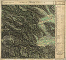
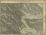
Historical maps
- St. Martin and its surroundings in the regional recordings from around 1790 to 1910
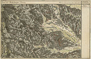
The area of “St. Marten ”as“ Part of the Mahrburger Kreis ”in the Josephinische Landesaufnahme , around 1790
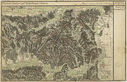
Otternitz (outside left)
Franziszeische Landesaufnahme , approx. 1835
St. Martin, around 1878

In the south of St. Martin is the former coal mining area around Pölfing and Brunn, record sheet 1: 25,000 around 1878

In the francisco-josephine land survey , approx. 1910


Web links
- 60347 - Sankt Martin im Sulmtal. Community data, Statistics Austria .
Individual evidence
- ↑ West Styrian Rundschau . No. 18, volume 2015 (May 1, 2015), 88th volume. ZDB -ID 2303595-X . Simadruck Aigner u. Weisi, Deutschlandsberg 2015, p. 14.
- ↑ This is how the 15 communities in Deutschlandsberg voted. meinviertel.at , June 29, 2020, accessed on August 18, 2020 .
- ↑ Local council election 2020 - results Sankt Martin im Sulmtal. orf.at , accessed on August 18, 2020 .
- ^ Styrian municipal structural reform .
- ↑ Section 3, Paragraph 2, Item 3 of the Act of December 17, 2013 on the reorganization of the municipalities of the State of Styria ( Styrian Municipal Reform Act - StGsrG). Provincial Law Gazette for Styria of April 2, 2014. No. 31, year 2014. ZDB -ID 705127-x . P. 2.
- ↑ Federal Office for Metrology and Surveying, Regional Information, reference date December 31, 2016, accessed February 19, 2017
- ↑ Statistics Austria: Population on January 1st, 2020 by locality (area status on January 1st, 2020) , ( CSV )
- ^ Ordinance of February 5, 1948 , Provincial Law Gazette for Styria of April 15, 1948, 6th issue , No. 21. P. 49.
- ↑ Ordinance of December 4, 1947 , State Law Gazette for Styria of December 24, 1947, Part 20, No. 40, p. 89.
- ↑ Law of December 18, 1967 on territorial changes of municipalities , Provincial Law Gazette for Styria of December 29, 1967, Part 26, No. 138, p. 188.
- ↑ Law of December 3, 1968 on territorial changes of municipalities , Provincial Law Gazette for Styria of December 27, 1968, Part 22, No. 164. P. 187.
- ↑ Gerald M. Wolf: "Now we are the gentlemen ..." The NSDAP in the Deutschlandsberg district and the July Putsch 1934 (= Grazer Zeitgeschichtliche Studien, Volume 3) StudienVerlag, Innsbruck-Wien-Bozen 2008, p. 167 fu 186, ISBN 978-3-7065-4006-3 .
- ^ Kurt Woisetschläger, Peter Krenn: Dehio Handbook - Die Kunstdenkmäler Österreichs: Styria (excluding Graz). Topographical inventory of monuments, ed. from the Federal Monuments Office, Department for Monument Research. Publisher Anton Schroll. Vienna 1982. ISBN 3-7031-0532-1 . P. 470.
- ↑ http://www.wolfram.at/das-unternehmen-wolfram/
- ^ Grazer Zeitung , Official Gazette for Styria. December 30, 2014, 210th year, 52nd piece. ZDB -ID 1291268-2 p. 631.
- ↑ Elections. Retrieved January 28, 2020 .
- ↑ 97. Announcement of the Styrian state government of October 29, 2015 on the granting of the right to use a municipal coat of arms to the municipality of Sankt Martin im Sulmtal (political district Deutschlandsberg) , accessed on November 3, 2015
- ↑ Visit to the twin town of Krempe: Parish of St Martin in Sulmtal. Retrieved January 28, 2020 .

Bad Schwanberg | Deutschlandsberg | Eibiswald | Frauental an der Laßnitz | Great Saint Florian | Lannach | Pölfing-Brunn | Preding | Sankt Josef (West Styria) | Sankt Martin im Sulmtal | Sankt Peter im Sulmtal | Sankt Stefan ob Stainz | Stainz | Wettmannstätten | Wies
93 Former communities (dissolved since 1945):
Aibl |
Aigen |
Bad Gams |
Blumegg |
Breitenbach in West Styria |
Dietmannsdorf im Sulmtal |
Ettendorf near Stainz |
Feisternitz |
Field tree |
Freidorf an der Laßnitz |
Open field near Deutschlandsberg |
Gamsgebirge |
Garanas |
Gasselsdorf |
Georgsberg |
Gersdorf |
Grafendorf near Stainz |
Graggerer |
Grass shoe |
Greisdorf |
Greith |
Gressenberg |
Großradl |
Grub near Groß Sankt Florian |
Grünau an der Laßnitz |
Gundersdorf |
Gussendorf |
Hasreith |
Herbersdorf |
Hollenegg |
Kleinradl |
Monastery |
Kornriegl |
Kothvogel |
Kraubath (West Styria) |
Krottendorf an der Laßnitz |
Kruckenberg |
Laaken |
Lasselsdorf |
Lebing |
Limberg near Wies |
Mainsdorf |
Marhof |
Mettersdorf |
Michlgleinz |
Nassau |
Neudorf near Stainz |
Neurath |
Niedergams |
Oberhart |
Upper Latin |
Oisnitz |
Osterwitz |
Otternitz |
Petzelsdorf in West Styria |
Pichling at Stainz |
Pirkhof |
Pitschgau |
Rassach |
Rossegg |
Rostock |
Red wine |
Sankt Oswald ob Eibiswald |
Sankt Ulrich in Greith |
Schönaich |
Sierling |
Soboth |
Stainztal |
Stable yard |
Stammeregg |
Sterglegg |
Sulmeck-Greith |
Sulz |
Sulz-Laufenegg |
Tanzelsdorf |
Teipl |
Tobis |
Tobisegg |
Trahütten |
Trough |
Unterbergla |
Vochera am Weinberg |
Vochera an der Laßnitz |
Front village |
Forest in West Styria |
Wernersdorf |
Wetzelsdorf in West Styria |
Wielfresen |
Wieselsdorf |
Torrent |
Wohlsdorf |
Zeierling |
Zirknitz