
Soboth (Eibiswald municipality)
|
Soboth ( locality ) locality cadastral community Soboth (community Eibiswald) |
|||
|---|---|---|---|
|
|||
| Basic data | |||
| Pole. District , state | Deutschlandsberg (DL), Styria | ||
| Pole. local community | Eibiswald | ||
| Coordinates | 46 ° 40 ′ 55 " N , 15 ° 4 ′ 28" E | ||
| Residents of the village | 272 (January 1, 2020) | ||
| Building status | 192 (2001 ) | ||
| Area d. KG | 3.47 km² | ||
| Postcodes | 8553, 8554 | ||
| Statistical identification | |||
| Locality code | 14585 | ||
| Cadastral parish number | 61140 | ||
| Source: STAT : index of places ; BEV : GEONAM ; GIS-Stmk | |||

Soboth (Former Congregation) |
|
|---|---|
| Basic data | |
| Pole. District , state | Deutschlandsberg (DL) district, Styria |
| Coordinates | 46 ° 40 ′ 55 " N , 15 ° 4 ′ 28" E |
| Statistical identification | |
| Community code | 60345 |
 Location of the former municipality in the Deutschlandsberg district |
|
| Independent municipality 1850–2014, since 2015 part of Eibiswald KG: Laaken, Soboth |
|
Soboth ( Slovenian : Sobota ) is a village in the municipality of Eibiswald in western Styria .
Until the end of 2014, Soboth was a municipality with 319 inhabitants (as of 2014) in the Deutschlandsberg district in Styria . As part of the Styrian municipal structural reform , Soboth was merged with the municipalities of Aibl , Eibiswald , Großradl , Pitschgau and St. Oswald ob Eibiswald to form the market municipality of Eibiswald from 2015 .
geography
Geographical location
Soboth is located in southern western Styria on the Koralpe . Soboth borders Slovenia and Carinthia . Soboth consists of two cadastral communities, Soboth in the north and Laaken (Slovenian: Mlake) in the south. The place is traversed by the Krumbach and the Feistritzbach. Important elevations are the Narrenfelsen with 1490 m and the Gradischkogel with 1389 m . The Dreieckkogel at 1528 m is at its highest point just east of the municipal boundary.
Soboth is located in protected landscape area no. 3 “Soboth-Radlpass”. This area is characterized by meadows and forests in a large-scale forest landscape, by grassland use and small-scale orchards. The protection serves to preserve the landscape character, the natural and near-natural landscape elements as well as the preservation of the landscape as a recreational area for the general public. For example, the large contiguous unspoilt areas such as near-natural forest areas, the structured cultivated landscape with its small biotopes such as bushes and groups of trees, the field and forest edge communities, the near-natural, structurally rich small bodies of water such as springs, streams, etc., the habitats for the animals and animals occurring in the protected area are protected Plant species and the near-natural stream sections.
Neighboring places
| Wielfresen | Saint Oswald | |
| St. Georgen |
.svg)
|
Aibl |
| Lavamünd | Dravograd | Muta |
Incorporations
On January 1, 1954, the previously independent municipality of Laaken was merged with Soboth.
As part of the Styrian municipal structural reform , Soboth was merged with the municipalities of Aibl , Eibiswald , Großradl , Pitschgau and St. Oswald ob Eibiswald to form the market municipality of Eibiswald from 2015 . The basis for this is the Styrian Municipal Structural Reform Act - StGsrG.
history
Origin of name
The place name Soboth comes from the Slavic word potòk , which can be translated as stream or river. This refers to the Krumbach and Feistritz, which have formed deeply cut valleys. Since the name refers to the entire area, the name can be translated as "place of deep, steep streams". This interpretation is supported in another source by a reference to the Slavic word sobota, sopot and its meaning “waterfall, rushing water”. The name Laaken is traced back to mlaka, mlake for “wet area, pool, swamp”, the term “ red wine ” to radvanje, raduvanje and thus to a root word meaning “happy”. The name of Feistriz can be derived from bystrica "clear stream", the name Krumbach from Slavic grm, gròm "thunder, rushing" etc.
Another interpretation is derived from the word Saturday (Slavic: Sobota , Hungarian: Szombat ), which regularly refers to a regular market or court day.
Soboth in the Middle Ages and Modern Times
The first written mention of a field name comes from the year 1311 with the area name in the Zambit (cf. Hungarian Szombat ) near the border with Carinthia (Obersoboth). Laaken was first mentioned in 1498 in the land register of the Schwanberg rule . The church of St. Jakob is first documented from 1615. In the 17th century Soboth belonged to the judicial district of Mahrenberg or to the district authority of Windisch-Graz .
In 1728 the Countess von Künburg built a glassworks which was named after her "Künburger Hütte". The glassworks south of the Zigeunerkogel already became a serious competitor for the hut in the village of Glashütten in Gressenberg around 1733 . In 1764, however, it was closed due to a lack of raw materials such as ash and firewood. In 1795 the smelter was reopened by glassmaker Georg Voith. Voith built the Spiegelglashütte east of St. Vinzenz , founded in 1687 and dedicated to the patron saint of woodcutters. It was finally closed in 1858.
Soboth from the 20th century
In the course of the border fighting with Yugoslav troops after the end of the First World War , there was a firefight in Soboth on March 12, 1919, in which two of the defenders of the place were killed and the place itself was occupied and looted by the Yugoslavs. In the referendum in the St. Urban mountain church in July 1920, the people of Soboth decided to remain with Austria. On October 20, 1920, Soboth was finally evacuated by the Yugoslav troops and received its final affiliation to Austria, which had already been confirmed in the Peace Treaty of St. Germain . Due to the new demarcation, Soboth now lacked any transport links to the rest of Austria, because with the Drautal the hinterland and thus the only economic connection to Soboth had been lost.
In order to remedy this situation, the connection to Eibiswald by building a freight road was urgently necessary. Due to a lack of money, this was a long time coming, which caused increasing bitterness among the population. In 1927 the Soboths gave air to their displeasure with the still unsuccessful construction of freight roads by boycotting the National Council election . Of 343 eligible voters, only 12 cast their vote. It was not until 1931 to 1937 that the Krumbach-St. Jakob created and the community is now connected to Eibiswald. The road was subsequently expanded and reached the Styrian border via Obersoboth (vulgo Skutnig) and Lavamünd in Carinthia.
In the wake of the Nazi July coup , a group appeared on 26 July 1934 by the Nazis before the police station and demanded the surrender of all weapons and the delivery of the contracted items on men the customs guard, but this was denied by the post commander. Thereupon the National Socialists withdrew again, probably because they wanted to bring in reinforcements, which, however, should never have arrived due to the rapid collapse of the coup. On the morning of July 27th, the gendarmerie succeeded in arresting two leaders of the July coup in Stainz , who were in the process of scouting the border crossing into Yugoslavia. Shortly afterwards, however, their like-minded people appeared and forced the release of the two National Socialists by threatening to shoot a married couple they had taken hostage.
Before the end of the Second World War , Yugoslav partisans occupied the gendarmerie post in Soboth in 1944. After the end of the war, seven different brigades took turns occupying the community. In 1954 the road between Eibiswald and the Styrian border was elevated to a state road. As its economic importance increased, the road (today: Südsteirische Grenzstraße B69) was expanded and reopened in 1974. Work on the construction of the Koralpe power plant began in 1987 and was completed in 1990. The Soboth reservoir is now also accessible through a community-owned lake cafe.
Population development
According to the 2001 census, Soboth had 421 inhabitants. 95.0% of the population had Austrian citizenship. 94.5% of the population professed to be part of the Roman Catholic Church, 3.1% were without religious beliefs.
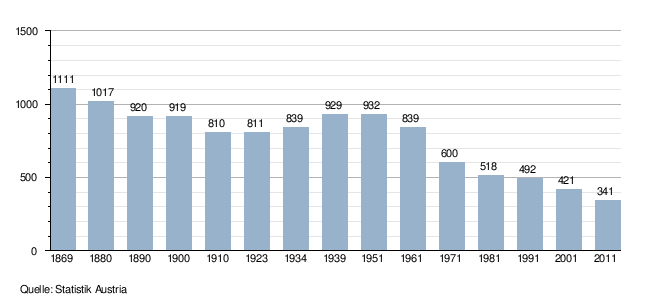
The population of Soboth has shrunk massively since 1869. Already between 1869 and 1910 the population fell by 27%. After that, the population was able to stabilize again and even increase slightly. Since 1951, however, the population has continued to decline and today it is only about a third of the population of 1869.
Culture and sights
- Parish church Soboth : The church of St. Jakob is first documented in 1545. However, it will probably have been around for a long time. In 1637 the church burned down to the walls as a result of a lightning strike. Reconstruction by the Mahrenberg pastors followed between 1645 and 1653, as the parishes of Soboth and Laaken belonged to the judicial district of Mahrenberg and the district authority of Windisch-Graz, respectively. A dedicatory inscription mentions the year 1704. Its high altar is dated 1659; It has been a parish church since 1789.
- With the branch church St. Leonhard in Zambichl (an old form of the name for Soboth: Janbicht, Zambigt, Zanviet, Zobodin, Zoubitg etc., not to be confused with St. Leonhard in the plain or with Lenart v Slovenskih goricah, formerly St. Leonhard in den Windischbüheln ) the community has another church building from the 17th century, which was built in 1645–1653 “in the traditional forms of Gothic country churches”. The dedicatory inscription mentions 1659. This church is located at an altitude of 1155 m near the Carinthian border. Originally there was a chapel at this point, which was visited by pilgrims as early as 1622. Around 1600, the provost Jakob Rosolenz from Stainz , known as a heretic persecutor , reported that in this area a meeting place for members of a sect who were called "Springer" because of their ritual dances and religious acts, "was set on fire and sent into the Lufft" . It would correspond to the procedure of the authorities at that time (as also at Osterberg ) to have built a (Catholic) church at the affected area.
- Another church is located on the Slovenian state border: At the St. Urban Church (1,330 m), the residents of Soboth recognized themselves by voting for Austria in 1920. The church burned down in 1977 and was restored in 1992.
- On July 15, 2012, the permanent exhibition on the subject of "350 years of glass art in the Koralpen region" was opened in the Jakobihaus. This exhibition deals primarily with the glassworks in Soboth. It was made possible by taking over a private sponsorship of the collector Erich Veronik from St. Oswald in Eibiswald and created in cooperation with the Burgmuseum Deutschlandsberg. It is part of the special exhibition “From forest glass to the first industrial glass - 3000 years of Styrian glass” in the Deutschlandsberg Castle Museum.
Economy and Infrastructure
According to the 2001 census of workplaces , there were 20 workplaces with 68 employees in Soboth as well as 87 out-commuters and 29 in-commuters. The most important sectors are public administration and the hotel and restaurant sector. There are 51 agricultural and forestry holdings (19 of which are the main occupation), which together farm 2,079 hectares (1999).
Traffic is opened up via the Südsteirische Grenzstraße (B 69).
The Kärntner Mariazellerweg (which merges into the Styrian Mariazellerweg in Eibiswald), a variant 03A of the Southern Alpine Trail and the Jakobsweg West Styria lead through Soboth .
politics
Municipal council
The last municipal council of Soboth was heavily dominated by the SPÖ . It reached 66.33% in the municipal council elections in 2005, an increase of 9.56%. The ÖVP suffered losses in 2005 and lost 4.07% to 33.67%. The FPÖ , which had already failed to move into the municipal council in 2000, no longer took part.
coat of arms
The coat of arms was awarded to the community in 2009 and presented on March 7, 2010 during a celebration. His description reads: “In a silver shield above a blue shield base covered with two silver fallen scallops, a silver wave bar, covered with seven individually juxtaposed blue waves, above a green Dreispitzberg, the middle point of which extends to the upper edge of the shield and with three silver ones from common parent rock growing long prismatic rock crystals is documented. ”The coat of arms contains heraldic symbols for the geographical location, the economic history and the ecclesiastical conditions of the municipality area: Two silver scallops refer to the two cadastral parishes of Soboth (first documented mention in the year 1311 under the area name“ in the Zambit ") And Laaken (first documented mention under the name" in der Lakhen "). A silver wave bar above it symbolizes the flowing waters of the municipality. Three rock crystals are arranged above this wave bar, which represent quartz as the basis for glass production in the area of Soboth and Pack. The frame is a green Dreiberg, which stands for the alpine world of the Soboth area.
Personalities
Honorary citizen
- 2000: Hans Wellacher (1929-2007)
- 2019: Siegfried Gödl (1944–2019)
Born in Soboth
- Hubert Koller (* 1960), civil servant and politician, member of the Austrian Federal Council
Historical maps of the Soboth
The border marking in the record sheets around 1877 indicates the border between the Marburger Kreis and Grazer Kreis, which in this area is not identical to the border between Austria and Slovenia.

Soboth was in the northwest of the Marburg district.

Unterdrauburg is in the southwest of the Soboth

The Drautal south of the Soboth with the confluence of the Feistritz in the Drau

Geological map of Soboth and its surroundings, around 1926


literature
- Helmut-Theobald Müller (ed.), Gernot Peter Obersteiner (overall scientific management): History and topography of the Deutschlandsberg district. ("District topography") Graz-Deutschlandsberg 2005. ISBN 3-901938-15-X . Styrian Provincial Archives and District Authority Deutschlandsberg 2005. In the series: Great historical regional studies of Styria. Founded by Fritz Posch †.
- Archim Behn: A glassworks on the Soboth. Dipl.-Arb. Graz 1985
- Klaus-Jürgen Hermanik: A hidden minority. Micro-study on bilingualism in the Styrian region of Soboth. Weitra, Verlag der Provinz 2007. ISBN 978-3-85252-817-5
- Johannes Moser, Elisabeth Katschnig-Fasch (ed.): Blatten. A village on the border. Graz: Druckwerk 1992 (= cuckoo. Notes on everyday culture and folklore. Special volume. 2.)
- Ernst Papesch: The attack on Radkersburg and the defensive battles in the Soboth and Eibiswald area in 1919 . In: Lot und Waage Volume 16 (1969), Issue 3/4 pages 7-11.
- Soboth parish: 300 years of Soboth parish church. Festschrift 1704-2004 . Soboth 2004
- Christian Fleck : Koralmpartisanen - About deviating careers of politically motivated resistance fighters. Ludwig Boltzmann Institute for Historical Social Science, materials on historical social science Volume 4. Verlag Böhlau. Vienna-Cologne 1986. ISBN 3-205-07078-X
- Herbert Blatnik: Contemporary witnesses remember the years 1938–1945 in Southwest Styria. 2nd Edition. Lerchhaus Verlag Eibiswald. December 2000. ISBN 3-901463-08-9
Web links
- Soboth hiking village
- A language disappears
- Statistical data on the former municipality (click on the individual lines on the linked page)
Individual evidence
- ^ Styrian municipal structural reform .
- ↑ Ordinance of the Styrian state government of December 19, 2013 on the declaration of areas of the Soboth and the Radlpass as landscape protection area No. 3. Styrian State Law Gazette of January 27, 2014. No. 10. ZDB -ID 705127-x . Pp. 1-2. This ordinance replaced the ordinance on the declaration of areas of the Soboth and the Radlpass as a landscape protection area, LGBl. No. 38/1981, most recently in the version LGBl. No. 64/1981.
- ↑ Ordinance of November 3, 1953 , State Law Gazette for Styria of December 31, 1953, Issue 18, No. 69, p. 90.
- ^ Styrian municipal structural reform .
- ↑ Section 3, Paragraph 2, Item 2 of the Act of December 17, 2013 on the reorganization of the municipalities of the State of Styria ( Styrian Municipal Reform Act - StGsrG). Provincial Law Gazette for Styria of April 2, 2014. No. 31, year 2014. ZDB -ID 705127-x . P. 2.
- ↑ Klaus-Jürgen Hermanik: A hidden minority. Pages 24-25.
- ↑ See: Heinz Richter: Our border in the south. 1919-1991. Graz: Verlag für Collectors 1993, pp. 46–51 and 156 as well as Kleine Zeitung No. 218 of September 20, 1953, p. 12: " The Soboth - Treueland der Steiermark ". - The grave of the two dead is still clearly recognizable in the cemetery through its large wooden cross.
- ↑ Gerald M. Wolf: "Now we are the gentlemen ..." The NSDAP in the Deutschlandsberg district and the 1934 July putsch (= Grazer Zeitgeschichtliche Studien, Volume 3) StudienVerlag, Innsbruck-Vienna-Bozen 2008, page 50, note 81. ISBN 978-3-7065-4006-3 .
- ↑ See: Gerald M. Wolf: "Now we are the gentlemen ..." The NSDAP in the Deutschlandsberg district and the July Putsch 1934 (= Grazer Zeitgeschichtliche Studien, Volume 3) StudienVerlag, Innsbruck-Vienna-Bozen 2008, page 177f. ISBN 978-3-7065-4006-3 .
- ↑ a b Kurt Woisetschläger, Peter Krenn: Dehio Handbuch - Die Kunstdenkmäler Österreichs: Styria (excluding Graz). Topographical inventory of monuments, ed. from the Federal Monuments Office, Department for Monument Research. Publisher Anton Schroll. Vienna 1982. ISBN 3-7031-0532-1 . Page 526-527.
- ↑ a b Get to know your homeland. On shoemaker's pony, Soboth (with reference to Viktor Geramb : Cultural and historical hiking trips through the Styrian Koralpen region. ). Weekly newspaper Weststeirische Rundschau from August 25, 2017. Volume 90, No. 34. Page 16.
- ↑ Soboth opens the glass exhibition "350 Years of Glass Art in the Koralpen Region". Weekly newspaper Weststeirische Rundschau from July 13, 2012. Volume 85, No. 28, page 1.
- ↑ Soboth receives municipal coat of arms. Weekly newspaper Weststeirische Rundschau from March 12, 2010. Volume 83, No. 10. Page 1.
- ^ Ordinance of the Styrian regional government of September 14, 2009 on the granting of the right to use a municipal coat of arms to the municipality of Soboth (political district Deutschlandsberg). Styrian Provincial Law Gazette of September 23, 2009. Volume 2009, No. 84, Issue 27, page 398.
- ↑ Information ( memento of December 6, 2011 in the Internet Archive ) of the Styrian state government of March 8, 2010 about the awarding of the municipal coat of arms.

Bad Schwanberg | Deutschlandsberg | Eibiswald | Frauental an der Laßnitz | Great Saint Florian | Lannach | Pölfing-Brunn | Preding | Sankt Josef (West Styria) | Sankt Martin im Sulmtal | Sankt Peter im Sulmtal | Sankt Stefan ob Stainz | Stainz | Wettmannstätten | Wies
93 Former communities (dissolved since 1945):
Aibl |
Aigen |
Bad Gams |
Blumegg |
Breitenbach in West Styria |
Dietmannsdorf im Sulmtal |
Ettendorf near Stainz |
Feisternitz |
Field tree |
Freidorf an der Laßnitz |
Open field near Deutschlandsberg |
Gamsgebirge |
Garanas |
Gasselsdorf |
Georgsberg |
Gersdorf |
Grafendorf near Stainz |
Graggerer |
Grass shoe |
Greisdorf |
Greith |
Gressenberg |
Großradl |
Grub near Groß Sankt Florian |
Grünau an der Laßnitz |
Gundersdorf |
Gussendorf |
Hasreith |
Herbersdorf |
Hollenegg |
Kleinradl |
Monastery |
Kornriegl |
Kothvogel |
Kraubath (West Styria) |
Krottendorf an der Laßnitz |
Kruckenberg |
Laaken |
Lasselsdorf |
Lebing |
Limberg near Wies |
Mainsdorf |
Marhof |
Mettersdorf |
Michlgleinz |
Nassau |
Neudorf near Stainz |
Neurath |
Niedergams |
Oberhart |
Upper Latin |
Oisnitz |
Osterwitz |
Otternitz |
Petzelsdorf in West Styria |
Pichling at Stainz |
Pirkhof |
Pitschgau |
Rassach |
Rossegg |
Rostock |
Red wine |
Sankt Oswald ob Eibiswald |
Sankt Ulrich in Greith |
Schönaich |
Sierling |
Soboth |
Stainztal |
Stable yard |
Stammeregg |
Sterglegg |
Sulmeck-Greith |
Sulz |
Sulz-Laufenegg |
Tanzelsdorf |
Teipl |
Tobis |
Tobisegg |
Trahütten |
Trough |
Unterbergla |
Vochera am Weinberg |
Vochera an der Laßnitz |
Front village |
Forest in West Styria |
Wernersdorf |
Wetzelsdorf in West Styria |
Wielfresen |
Wieselsdorf |
Torrent |
Wohlsdorf |
Zeierling |
Zirknitz