
Wettmannstätten
|
market community Wettmannstätten
|
||
|---|---|---|
| coat of arms | Austria map | |
 |
|
|
| Basic data | ||
| Country: | Austria | |
| State : | Styria | |
| Political District : | Deutschlandsberg | |
| License plate : | DL | |
| Surface: | 17.97 km² | |
| Coordinates : | 46 ° 50 ' N , 15 ° 23' E | |
| Height : | 320 m above sea level A. | |
| Residents : | 1,621 (January 1, 2020) | |
| Postal code : | 8521 | |
| Area code : | 03185 | |
| Community code : | 6 03 41 | |
| NUTS region | AT225 | |
| Address of the municipal administration: |
Wettmannstätten 2 8521 Wettmannstätten |
|
| Website: | ||
| politics | ||
| Mayor : | Peter Neger ( ÖVP ) | |
|
Municipal Council : (2020) (15 members) |
||
| Location of Wettmannstätten in the Deutschlandsberg district | ||
  |
||
| Source: Municipal data from Statistics Austria | ||

Wettmannstätten is a market town with 1621 inhabitants (as of January 1, 2020) in the Deutschlandsberg district in Styria .
geography
The municipality of Wettmannstätten is located at the meeting point of the Wieserbahn and the Koralmbahn in the western Styrian hill country.
Community structure
The municipality consists of six cadastral communities or towns of the same name (area: as of December 31, 2018; inhabitants as of January 1, 2020):
- Lassenberg (345.99 ha; 189)
- Schönaich (265.47 ha; 246)
- Weniggleinz (201.31 ha; 116)
- Wettmannstätten (336.78 ha; 595)
- Wohlsdorf (370.51 ha; 274)
- Zehndorf (276.47 ha; 201)
Incorporations
On January 1st, 1968 Lassenberg, Schönaich and Wohlsdorf as well as part of the former municipality Michlgleinz (the cadastral municipality of Weniggleinz) were incorporated. The communities of Wohlsdorf and Schönaich were created with effect from 1931 through the separation of the former community of Wohlsdorf. This community in turn emerged as Schönaich-Wohlsdorf only in 1920 from the separation of the previous community Gussendorf and in 1922 changed its name to “Wohlsdorf”.
The municipality was not affected by the Styrian municipal structural reform , which reduced the number of municipalities in the Deutschlandsberg district from 40 to 15 by 2015.
Neighboring communities
Two of the five neighboring communities are in the Leibnitz (LB) district.
| Stainz | Preding | |
.svg)
|
St. Nikolai im Sausal (LB) | |
| Great St. Florian | St. Andrä-Höch (LB) |
history
The area of the municipality of Wettmannstätten in the Laßnitztal is one of the areas in which a number of archaeological sites have been occupied since the Bronze Age. In total, the areas of archaeological excavations in this part of the Laßnitz valley are over 40 hectares in size.
Archaeological finds have been made from prehistory to modern times. Excavations on the occasion of the laying of the Adria-Wien pipeline revealed a number of pits with prehistoric material up to the urn field culture . During the work on the east portal of the Koralm tunnel , a well with a wooden well box from the Middle Bronze Age was found in the district of Wohlsdorf , which indicates that the area was already densely populated as early as 1600-1300 BC. Was documented and assessed as a material source of international importance. After its discovery, the well was not excavated, but rather recovered as a whole and scientifically examined in detail in a 17-ton block including the surrounding soil for the purpose of further scientific investigation.
Excavations in 2008 in the Schönaich area uncovered further finds from the Bronze Age. Remnants of the Roman road in the Laßnitz valley were also found near Zehndorf. Finds from the Bronze Age and the Roman Empire are documented in Wohlsdorf. Another reason for archaeological finds was the work on the oil and gas pipelines ( AWP and TAG ) that cross the municipality.
On Lassenberg there was probably a settlement from the Latène period (5th to 1st century BC), which was important until the Roman Empire. Individual finds document this period, such as a cutting knife, a lance tip and a sword chain, all made of iron . It has not yet been established whether these were grave goods. Robbery excavations also make it difficult to reliably document the finds.
The place was part of the Mark Steiermark, created in 1122, which was separated from Bavaria as the Duchy of Styria in 1180 . From 1192 the area was ruled by the Babenbergs in personal union between Austria and Styria. From 1282 to 1918 the area was under the rule of the Habsburgs . On November 6, 1918, Wettmannstätten came to the Republic of German-Austria as part of Styria. After the annexation of Austria in 1938, the community became part of the Reichsgau Steiermark, from 1945 to 1955 it was part of the British zone of occupation in Austria.
Wettmannstätten has been a parish since 1921, before it belonged to the parish of Groß St. Florian. The church of Wettmannstätten was built between 1712 and 1718, it was demolished in 1969 because the damage could not be renovated. Parts of their furnishings were taken over in the new church of St. Valentine, which was built between 1965 and 1967.
The Wohlsdorf branch of the Stainzer local railway is located on the northern border of the community near Wohlsdorf .
A chapel built in 1959 is located in the Zehndorf part of the municipality. Your altar and his statue of the Virgin Mary had been set up in Schwarzenegg Castle near Wildon since 1736; they were previously in the former Herberstein Castle. In the 18th century, healing powers were ascribed to the statue in Schwarzenegg.
Population development

Culture and sights
- Wettmannstätten parish church
- The course of the Saubach and its banks in the cadastral communities of Wohlsdorf and Schönaich are under nature protection (area NSG-c103). This area is located south of the triangle of the Koralmbahn with the Wieserbahn and the route of the L 601 Schröttenstraße. It has the name "nature reserve part of the Saubach including the banks" and the purpose of protecting stocks of the yellow pond rose (Nuphar luteum) .
- Another nature reserve is the “dead arm area of the Gleinzbach” (NSG-c07). The area is located southwest of the Waldschacher Teiche about 170 m south of the intersection of the L 303 Predinger Straße and the L 639 Wohlsdorfer Straße. It concerns the area of a former oxbow lake of the Gleinzbach, which was separated from the water after the river regulation. The area is 0.84 hectares and was declared a nature reserve on March 25, 1974. The protected area is endangered by the drying up and over-fertilization of its neighboring areas. Its purpose is to protect a population of the yellow pond rose (Nuphar luteum). This stock is in decline, leaves of this plant were only found in one place last.
traffic
The community is located on the L 601 state road, which runs in the Laßnitz valley and connects the Murtal with the Deutschlandsberg district. GKB bus routes connect the community with the surrounding area for school transport. A stop on the Graz – Lieboch – Wies-Eibiswald line of the Graz – Köflacher Bahn (GKB) is located north of Wettmannstätten. Trains to Graz and Wies - Eibiswald run every hour from there on weekdays and every two hours on Sundays and public holidays . The community is also on the route of the Koralm Railway, which is under construction . For this railway line, the course of the Laßnitz was redesigned over a river length of more than two kilometers in 2008/09 and flood retention basins were created. As part of this work, the Laßnitz bridge between Gussendorf and Lassenberg near Wettmannstätten was rebuilt as a 142 m long and 14.5 m high reinforced concrete bridge and opened to traffic on August 29, 2008.
politics
The municipal council consists of 15 members and has been composed of mandates from the following parties since the 2015 municipal council election:
- mayor
- since January 26, 2016: Peter Neger (ÖVP)
coat of arms
Wettmannstätten has been a market town since January 1, 1973 and was given the right to use a coat of arms on this occasion. Description of the coat of arms:
- "In a shield divided from silver to green obliquely to the left, in front three red roses sprouting from a red heart, behind a golden cob of corn placed obliquely to the left."
Combined in the Styrian national colors, the coat of arms juxtaposes a symbol for the flower miracle of St. Valentine as the local parish patron and for the maize cultivation that is important in the municipality at the time of the award.
Personalities
Honorary citizen of the community
- 1979: Friedrich Niederl (1920–2012), governor
- 1985: Josef Krainer (1930–2016), governor
- 2016: Helmut Kriegl, Mayor (1987–2015)
Sons and daughters of the church
- Johann Haring (1867–1945), theologian and university professor
People related to the community
- Georg Gimpl (1887–1947), pastor and politician
- Walter Kröpfl (* 1951), politician of the SPÖ
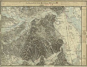
Historical maps
- Wettmannstätten and its surroundings in the regional recordings of the Austro-Hungarian monarchy

Wettmannstätten and its southern surroundings: Gleinz, Sausal in the Josephinische Landesaufnahme , approx. 1790

The north of Wettmannstätten around 1790
Wettmannstätten in the south of the Laßnitz, recording sheet 1879

In the francisco-josephine land survey , approx. 1910


Web links
- 60341 - Wettmannstätten. Community data, Statistics Austria .
- wettmannstaetten.gv.at Homepage of the municipality
Individual evidence
- ↑ This is how the 15 communities in Deutschlandsberg voted. meinviertel.at , June 29, 2020, accessed on August 18, 2020 .
- ↑ Municipal council election 2020 - results Wettmannstätten. orf.at , accessed on August 18, 2020 .
- ↑ CSV file from REGIONALINFORMATION.zip (1,221 KB) ; accessed on January 12, 2019
- ↑ Statistics Austria: Population on January 1st, 2020 by locality (area status on January 1st, 2020) , ( CSV )
- ↑ Law of December 18, 1967 on territorial changes of municipalities , Provincial Law Gazette for Styria of December 29, 1967, Part 26, No. 138, p. 188.
- ↑ Law of March 20, 1930 regarding the separation of the local community of Wohlsdorf , State Law Gazette for Styria of May 24, 1930, 9th part, No. 47. P. 74.
- ↑ Law of April 30, 1920 , State Law Gazette for Styria of June 30, 1920, Part 69, No. 144, p. 250.
- ^ Announcement of the governor in Styria of April 30, 1922 , State Law Gazette for the State of Styria of May 10, 1922, Issue 36, No. 141. pp. 137-138.
- ^ Styrian municipal structural reform .
- ↑ Gerald Fuchs: News from the Laßnitztal. Archeology in the Weitersdorf-Wettmannstätten section of the Koralm Railway. In: Find reports from Austria. Volume 48, year 2009, Vienna 2010, pp. 290–302.
- ^ Find reports from Austria. Published by the Federal Monuments Office, Volume 47, year 2008, Vienna 2009, pp. 541–542.
- ↑ Gerald Fuchs, Michael Fürnschuß: KG Wohlsdorf - AWP assignment. In: Find reports from Austria. Published by the Federal Monuments Office. Volume 45, year 2006, Vienna 2007, pp. 258–265.
- ↑ Weekly newspaper “Weststeirische Rundschau” from May 9, 2009, 82nd volume no. 19, p. 5.
- ↑ Gerald Fuchs: News from the Laßnitztal. Archeology in the Weitersdorf-Wettmannstätten section of the Koralm Railway. In: Find reports from Austria. Volume 48, year 2009, Vienna 2010, pp. 299-300 (with pictures).
- ↑ Gerald Fuchs, Gerhard Harer, Irmengard Kainz, Klaus-Michael Schneider: A model case for the collaboration between planning and archaeological monument preservation using the example of the Koralm Railway Graz – Klagenfurt in the Werndorf – Deutschlandsberg section. In: Find reports from Austria (FÖ). Published by the Federal Monuments Office, Vienna; Volume 36, year 1997, ISBN 3-85028-305-4 , pp. 269-280, with an overview plan of the archaeological sites and areas of hope in the central Laßnitz valley.
-
↑ Bernhard Hebert u. a .: Selected contributions to the specialist discussion “Wet wood conservation” on May 11, 2010 in Graz. With the contributions:
- Gerald Fuchs: Wohlsdorf - Bronze Age settlement and well. Pp. 182-187.
- Robert Fürhacker, Anna Kathrin Klatz: The Middle Bronze Age fountain from Wohlsdorf. Salvage and previous conservation and restoration measures. Pp. 188-195.
- Michael Grabner: Investigations of the well box wood from Wohlsdorf. Pp. 196-197.
- Everything in: Nikolaus Hofer (Ed.): Find reports from Austria. Volume 49, year 2010, ed. from the Federal Monuments Office, Berger Verlag, Vienna 2012, ISSN 0429-8926 , pp. 181-201.
- ^ Find reports from Austria. Published by the Federal Monuments Office. Volume 47, year 2008. Vienna 2009, pp. 589–590.
- ↑ Gerald Fuchs: The Roman Road in Laßnitztal, West Styria - a research report. In: Elisabeth Walde , Gerald Grabher (Ed.): Via Claudia Augusta and Roman Road Research in the Eastern Alpine Region. Innsbruck university press. In the series: IKARUS Innsbrucker classic-archaeological university publications. Volume 1, Innsbruck 2006, ISBN 978-3-901249-92-1 , pp. 440–456 (with maps and cadastral plans for the exact course of the road).
- ^ Find reports from Austria. Published by the Federal Monuments Office, Volume 47, year 2008, Vienna 2009, p. 543.
- ↑ Michael Brandl u. a .: Archaeological investigations on the Adria-Vienna pipeline in Laßnitztal, western Styria. In: Find reports from Austria. Volume 45, year 2006, Vienna 2007, pp. 257–280.
- ^ Susanne Sievers , Otto Helmut Urban , Peter C. Ramsl: Lexicon for Celtic Archeology. A – K, LZ . Publishing house of the Austrian Academy of Sciences , Vienna 2012, ISBN 978-3-7001-6765-5 , p. 1131.
- ^ Kurt Woisetschläger, Peter Krenn: Dehio Handbook - Die Kunstdenkmäler Österreichs: Styria (excluding Graz). Topographical inventory of monuments, ed. from the Federal Monuments Office, Department for Monument Research. Verlag Anton Schroll, Vienna 1982, ISBN 3-7031-0532-1 , pp. 615-616.
- ↑ Weekly newspaper “Weststeirische Rundschau” from August 15, 2009, Volume 82, No. 33, p. 6.
- ↑ Ordinance of the BH Deutschlandsberg ( page no longer available , search in web archives ) Info: The link was automatically marked as defective. Please check the link according to the instructions and then remove this notice. , effective from August 28, 2010 (previously: Ordinance of September 18, 1967) on the declaration of a part of the Saubach including the riparian strip as a nature reserve. Grazer Zeitung, Official Gazette for Styria, year 2010, ZDB -ID 1291268-2 p. 460.
- ↑ Documents from the Office of the Styrian Provincial Government.
- ↑ Ordinance of the BH Deutschlandsberg ( page no longer available , search in web archives ) Info: The link was automatically marked as defective. Please check the link according to the instructions and then remove this notice. a dead arm area of the Gleinzbach in the market town and KG Wettmannstätten to the nature reserve (plant protection area, previously: Ordinance of the Styrian provincial government of March 25, 1974, Styrian State Law Gazette No. 31 , with location map on p. 52), Grazer Zeitung, Official Gazette for Styria, year 1990, ZDB -ID 1291268-2 p. 516.
- ↑ Documents from the Office of the Styrian Provincial Government.
- ↑ Weekly newspaper “Weststeirische Rundschau” from September 6, 2008, 81st year, No. 36, p. 5.
- ↑ Elections. Retrieved January 29, 2020 .
- ↑ Market town of Wettmannstätten: Politics & Administration. Retrieved January 29, 2020 .
- ^ Market town of Wettmannstätten: coat of arms. Retrieved January 29, 2020 .

Bad Schwanberg | Deutschlandsberg | Eibiswald | Frauental an der Laßnitz | Great Saint Florian | Lannach | Pölfing-Brunn | Preding | Sankt Josef (West Styria) | Sankt Martin im Sulmtal | Sankt Peter im Sulmtal | Sankt Stefan ob Stainz | Stainz | Wettmannstätten | Wies
93 Former communities (dissolved since 1945):
Aibl |
Aigen |
Bad Gams |
Blumegg |
Breitenbach in West Styria |
Dietmannsdorf im Sulmtal |
Ettendorf near Stainz |
Feisternitz |
Field tree |
Freidorf an der Laßnitz |
Open field near Deutschlandsberg |
Gamsgebirge |
Garanas |
Gasselsdorf |
Georgsberg |
Gersdorf |
Grafendorf near Stainz |
Graggerer |
Grass shoe |
Greisdorf |
Greith |
Gressenberg |
Großradl |
Grub near Groß Sankt Florian |
Grünau an der Laßnitz |
Gundersdorf |
Gussendorf |
Hasreith |
Herbersdorf |
Hollenegg |
Kleinradl |
Monastery |
Kornriegl |
Kothvogel |
Kraubath (West Styria) |
Krottendorf an der Laßnitz |
Kruckenberg |
Laaken |
Lasselsdorf |
Lebing |
Limberg near Wies |
Mainsdorf |
Marhof |
Mettersdorf |
Michlgleinz |
Nassau |
Neudorf near Stainz |
Neurath |
Niedergams |
Oberhart |
Upper Latin |
Oisnitz |
Osterwitz |
Otternitz |
Petzelsdorf in West Styria |
Pichling at Stainz |
Pirkhof |
Pitschgau |
Rassach |
Rossegg |
Rostock |
Red wine |
Sankt Oswald ob Eibiswald |
Sankt Ulrich in Greith |
Schönaich |
Sierling |
Soboth |
Stainztal |
Stable yard |
Stammeregg |
Sterglegg |
Sulmeck-Greith |
Sulz |
Sulz-Laufenegg |
Tanzelsdorf |
Teipl |
Tobis |
Tobisegg |
Trahütten |
Trough |
Unterbergla |
Vochera am Weinberg |
Vochera an der Laßnitz |
Front village |
Forest in West Styria |
Wernersdorf |
Wetzelsdorf in West Styria |
Wielfresen |
Wieselsdorf |
Torrent |
Wohlsdorf |
Zeierling |
Zirknitz