
Bad Gams


Bad Gams is a place in western Styria . Until the end of 2014 it was a market town with 2306 inhabitants (as of 2014) in the south-west of Styria in the Deutschlandsberg district (former Stainz judicial district ). As part of the Styrian community structural reform, Bad Gams was merged with the communities Deutschlandsberg, Freiland bei Deutschlandsberg, Kloster, Osterwitz and Trahütten to form the town of Deutschlandsberg in 2015 . The basis for this is the Styrian Municipal Structural Reform Act - StGsrG. A merger and development agreement with Deutschlandsberg and Kloster was signed on November 18, 2013.
The small health resort is around 30 km from Graz . Tourism and viticulture are important sources of income. Old farmhouses with typically acute-angled West Styrian tile roofs, along with old barrows from the time of the Celts, testify to early settlement at the foot of the 800 meter high Gamsgebirge.
Geography and geology
Bad Gams is located in the Styrian hill country of the West Styria region . The southern to western border is formed by the Laßnitz and the Wildbachtal . In the northwest, the border runs over the Reinischkogel and the Absetzwirt to the 1,362-meter-high Rosenkogel, a popular hiking area for residents of the surrounding area and the provincial capital Graz . Bad Gams has a spacious, artificially created bathing lake, which, in addition to extensive meadows and cultivated areas with numerous fruit trees, characterizes the townscape of Bad Gams. The mild climate allows sweet chestnuts and pumpkins to ripen in autumn .
Bad Gams is on the eastern border of the coral range, on the border of the crystalline rock (gneiss, amphibolite, etc.) to the rocks (gravel, breccia, etc.) from the Neogene (formerly known as the Tertiary ) that form the Graz Basin. Gams is partially located on one of the eight published slab gneiss areas in the eastern Koralpe, the "Gams complex".
The rocks on which Bad Gams lies have been scientifically examined in detail. The streams are partially cut deep into the crystalline. The steep slopes of these valleys lead to landslides through which mineral discovery sites are opened up. Road constructions (especially for forest roads) and quarries also make discovery sites, e.g. B. for grenade , accessible. In the cadastral community of Sallegg, sites of discovery are formed along the Wildbach Valley by around a hundred pegmatites of different thicknesses (from a decimeter range up to 20 meters and more). In them, uranium minerals ( autunite , torbernite , uraninite ), uranium opals, tourmaline , zircon , dumortierite and other minerals were found in small quantities with crystals in millimeter size .
Local division
Bad Gams comprises thirteen cadastral communities .
Neighboring places
Stainz Monastery Marhof Rassach Freiland near Deutschlandsberg Deutschlandsberg Frauental an der Laßnitz
Small region
The community of Bad Gams was one of the six members of the community association "Core area Bad Gams - Deutschlandsberg - Frauental" (with monastery, Osterwitz and Freiland). In this community association the tasks of road maintenance, shopping and child and youth care should be done together. The association was constituted on December 9, 2010. It has legal personality and is based on a voluntary agreement. Its seat is Frauental, its legal basis is § 38a of the municipal code.
On September 29, 2013, at the joint request of the three opposition parties, against the will of the ruling party, a referendum took place (pursuant to Section 159 Styrian People's Rights Act) on the merger with the district town of Deutschlandsberg. With a turnout of 45%, 74% of the participants, thus a total of 34% of those eligible to vote, expressly opposed a merger in this way.
history
Prehistoric time
In the cadastral community of Sallegg, on the course of the wild brook (Wildbachgraben), two " flint bulbs " made of jasper and other flint tools were found. These pieces are located with other stone tools in the museum of Deutschlandsberg Castle and point to a settlement from prehistoric times in this area.
middle Ages
Bad Gams owes its name to the Slavs who immigrated to what is now western Styria at the end of the 6th century. The name comes from the Slavic words Kamnice (quarry) or Gamenic (stone). From the 8th century the Slavs had to recognize the sovereignty of the Bavarians, at the end of the 9th century the Hungarians occupied parts of Styria. It was not until 1043 that King Heinrich III. the Hungarians in the fight against Sámuel Aba finally drive out of Central Styria. The Bad Gams area was first mentioned in a document in 1100 in a deed of donation from Salzburg Archbishop Tiemo , who gave Admont Abbey a quarter of a hat in Hohenvelt (Hohenfeld). The possessions near Gams were administered by the Admont Abbey through its provost in St. Martin near Strassgang .
The Sallegg area was designated as Dorfstetten in 1265 . The part of the name Sal- denotes a (legally) transferred settlement and indicates the transfer of this settlement area to the Admont Abbey . In land records and other documents from the 15th century (1434 etc.) there are written variants such as Saleck, Salegk, am Salchek .
The foundation walls of the house vlg. Greimbauer am Greimkogel in the west of Bad Gams are the remains of a tower courtyard, a medieval defense structure, which is also called "Greim Castle". It is assumed that the building is the remains of a tower courtyard from the 12th / 13th centuries. Century acts, a use as a refuge is also being considered. In 1225 the facility was owned by Konrad von Wildon , a servant of Leuthold von Wildon . A long dispute over the boundaries of ownership of Admont Abbey was settled in 1325. The ground floor walls of this house are over 80 cm thick, and a room used as a cellar has loopholes in the walls. In a document dated September 24, 1319 a Fritzel ab dem Greym is mentioned, in a document dated March 8, 1383 the widow of an Albrecht des Greymer . During excavations, a trench with a bottom width of 1.80 m to 2.50 m was found. In the 19th century there was still a curtain wall, a tower was demolished in 1870 because it was dilapidated. The remains of the defense tower are located about 70 meters southwest of the existing courtyard building on a rock massif that is about 25 m high.
Modern times
According to the quarter division of Styria in 1462 , Gams belonged to the "quarter dieshalb der Piberalm", which was later called the "quarter between Mur and Drau". In general, the authorities of the Marburg district of the Duchy of Styria were responsible. These authorities were based in Marburg . From 1849 the area was in the Graz district .
In the village of Gersdorf, southeast of Bad Gams, the Pramerhof was located in the 16th and 17th centuries . This complex belonged to the noble Pramer family, who owned extensive land in western Styria. It was a farmyard on a hill between Gamsbach and Vocherabach near the later Mertlmühle (Mörtlmühle), of which only the foundation walls were recognizable in 1880 and nothing has survived. The property was on the flat area north of the farm vlg. Roadl at Gersdorfweg No. 2. In 1424 Konrad Pramer owned a number of goods and other rights in the area of Tobis , Stainz and Gams. The family had functions in the administrative service of the Styrian rulers. The Pramer family died out with Hans II the Pramer in 1572. The farm was sold in 1583 by Hans Pramer's daughter, Esther, to her husband Hans Frölich, and in 1602 by his son Hans Dietrich to Georg Sigmund zu Wildenstein, who connected it to his rulership of Wildbach . At the end of the 18th century, the complex was known as "the free court of Gersdorf". It is believed that it was finally abandoned in the 18th century.

The "Absetzwirt" between Rosenkogel and Reinischkogel on the border with the Marhof area in the west of Gams is on an old road that led from Stainz to the area via the Hebalm or the Pack to Carinthia. The name evidences the "setting down" (unloading) of (load) loads. The Abetzwirt was a place where load transports took a break or where loads were transferred from one means of transport to another. This is because not all carters were allowed to leave the area of their manorial rule and therefore transports to borders had to be handed over to other transporters.
In the 16th and 17th centuries, the area of Bad Gams belonged to the " Oberwildon Regional Court ", with jurisdiction changing and disputes over jurisdiction as with Gams in 1624/25 were not uncommon. The list of truce noted, "... should one have to be purgfrid but niemahls gestatt to Gämbs ...". However, this only applied outside the eaves : within it, full lower jurisdiction lay with the respective landlord in the 16th century. The high jurisdiction (blood jurisdiction) lay with the regional court Ober-Wildon .

From 1770, in the first person and house registration in Austria , houses and people from Gams are recorded in numbering sections within the parish of Gams (also called Konskriptionsgemeinden). The parish area of Gams was larger before the reorganization of the parishes under Emperor Joseph II (Josephinian parish regulation) than afterwards. The sections were based on the localities or settlement areas. Sallegg, Feldbaum, Greim, Hohenfeld, Mitteregg, Müllegg, Gams, Bergegg, Vochera am Weinberg, Gersdorf, Furth, Wildbach and Hinterleiten belonged to the Wildbach advertising district , which was located in Wildbach Castle . This was also the case for the other numbering sections in the northeast of the Gams parish (Gamsgebirg, Neurath and Kothvogl) until 1805, after which these belonged to the Stainz advertising district, while parts of the Groß St. Florian parish (Blumau, Wildbachdorf, Wildbachberg and Niedergams) with the The remaining Gamser sections were connected to the Wildbach advertising district. The numbering sections became the tax municipalities of the same name in the 18th century and the cadastral municipalities at the beginning of the 19th century .
During the National Socialist July coup in 1934, the four-man gendarmerie post was attacked by National Socialists who came from Stainz. During the extremely violent exchange of fire, two men in the guard were seriously injured, one of whom died the following day. A filling of the post by the National Socialists could be prevented. A few hours after this incident, the National Socialists from Stainz made another attempt to assault the gendarmerie post, which, however, was refused again by the commandant, who was now alone at the post. According to the security director's report, a total of around 400 shots were fired at the post building.
The battles of World War II did not affect Bad Gams. On April 2, 1944, however, a US Air Force plane crashed over Sallegg. It was a B-24 Liberator bomber , six of the ten crew members were killed.
Establishment of the community, health resort and viticulture
- The municipality of Gams was created in 1850 from the then existing cadastral communities of Gams, Mitteregg, Hohenfeld, Sallegg, Müllegg, Feldbaum, Greim and Bergegg.
- In 1908 Feldbaum with Sallegg and Bergegg was separated from Gams as an independent municipality, the Gams municipal committee had decided on December 28, 1905.
- On October 1, 1947, the community name was changed to Gams ob Frauental (to make the difference to Gams near Hieflau and Gams near Frohnleiten clearer).
- On January 1st, 1968 Niedergams and Vochera am Weinberg were incorporated.
- Before that, on January 1, 1948, the community of Gersdorf was forcibly merged with Niedergams.
- The name of the municipality Vochera had changed to Vochera am Weinberg on June 1, 1951 .
- The municipality of Feldbaum, which was separated in 1908, was reunited with the municipality of Gams ob Frauental on January 1, 1974.
- Gams became a market town on September 1, 1978.
- Since July 1, 1980, the name of the community has been "Bad Gams".
- Bad Gams was awarded the title health resort in 1982 because of its iron healing springs . The Michel, the Gudrun and the Aktivquelle can be consumed directly in the Quellenhaus and can also be obtained from retailers. The healing spring "Michelquelle" was discovered in 1957. In 1961, based on an analysis by Univ.-Prof. Dr. F. Hölzl from the Institute for Analytical Chemistry in Graz presented the “St. Hubertus Quelle ”has been recognized as a healing spring. This spring is located around 650 m north of the Michel spring in the rising valley flanks of the Mittereggbach. The healing spring was taken from a depth of 2.1 to 3.4 m by drainage lines and ended in a shaft. In the last analysis by the Hygiene Institute Graz on April 17, 1990 (Protocol No. 822/90), by Univ.-Prof. Dr. G. Knapp reported a (total) iron content of 38.5 mg / l. Thereafter, at the instigation of the community under Mayor Theo Weichmann and in consultation with the owner representatives, the withdrawal of the mineral spring status was sought. The drinking house was converted for commercial use and only the spring house behind it remained.
Bad Gams has become known as a tourism and wine-growing area. The focus in wine production used to be on Schilcher viticulture (Blauer Wildbacher) and today more than twelve winegrowers cultivate Schilcher wines on their vineyards. In recent years, more and more vineyards have been planted with typical Styrian white wine grapevines.
population

Population structure
According to the 2001 census, Bad Gams had 2,300 inhabitants. 96.1% of the population had Austrian citizenship. 88.8% of the population committed to the Roman Catholic Church, 6.9% were without religious beliefs.
Population development
The population of Bad Gams has remained almost the same over the years. Fluctuations in the population also remained within a range of less than 10%.
Sons and daughters of the church
- Karl Schwer (1911–1988), politician (ÖVP)
- Herta Winkler (1917–2003), politician (SPÖ)
- Ludmilla Parfuss (* 1942), politician (SPÖ)
Eduard Wagnes
One of the best-known residents of Bad Gams is the military bandmaster Eduard Wagnes , who lived in a romanticist villa in Gams from 1924 to 1936 and, as bandmaster of the 2nd Bosnian-Herzegovinian infantry regiment, created works such as “Felsenfest fürs Vaterland” or “The Bosniaks are coming” . Born as the son of an instrument maker in Graz, his path from French horn player in the Radegund spa orchestra soon led him to the Graz city theater. After joining the 27th Infantry Regiment and his military career as a military bandmaster, Eduard Wagnes immediately moved from Banja Luka to Gams and found his calling as a composer from then on.
Culture and sights
See also: List of listed objects in Deutschlandsberg
Parish church
The parish church of Bad Gams is dedicated to St. Bartholomew . It is mentioned for the first time in 1165 and belonged to the Archdiocese of Salzburg until 1373 , then to the Diocese of Lavant (Kommissariat Groß St. Florian) until 1790 and from then to the Diocese of Graz-Seckau . On June 13, 1515, the Lavant Bishop Leonhard Peurl consecrated two bells of St. Mary and St. Anna , the mother of Mary, for the parish church in Gams . On October 22, 1534, Philipp Renner, as coadjutor Leonhard Peurls, renewed the consecration of the cemetery and the parish church. The reason for this is not mentioned in the consecration protocol , but according to other notes and publications, this consecration can also be traced back to the desecration of the church premises by the Turkish invasion . The consecration of a portable altar for the church in Gams is documented on October 10, 1638, and relics of St. Achatius and Roman martyrs were deposited in it.
Gams was first designated as a separate parish in 1382. However, since a pastor Nikolaus in Gams is mentioned as early as 1312, the existence of the parish around 1300 is not unlikely. According to another source, in 1376 the district of Gams is named as the "eternal vicariate ", and in 1445 it was elevated to the status of a parish. In the time before the parish was elevated, the name as vicariate was based on the fact that the entire parish of Groß St. Florian, to which the area originally belonged, belonged to the episcopal table of the diocese Lavant. This meant that the Bishop of Lavant was formally himself a pastor in St. Florian, but had to have this parish looked after by (permanently appointed, thus "eternal") vicars. Areas that were further away from the parish church Groß St. Florian - as is the case with Gams - had their own churches with priests. The leading priests of such a branch church had the rights of a pastor without being such (under canon law). This situation can give rise to uncertainties about the parish survey.
In 1660 the church was badly damaged by fire and an emergency church was built afterwards. From 1727 to 1735 the church building was rebuilt by Sebastian Tengg (Dengg); this building was not completed until 1747. Exterior restorations took place in 1912 and 1961 to 1965, interior restorations in 1836, 1877, 1886, 1913 and 1969.
The tower stands on Romanesque foundations . The two lower floors of the tower are Gothic , it was raised in 1755. In 1868 the baroque onion roof of the tower was replaced by a pyramid-shaped roof. This tower helmet was restored in 1972. The two bells, consecrated on June 13, 1515, were the first ringing of the tower. Another bell came from 1551. The bells had to be delivered in 1916, a new bell was inaugurated in 1922, and it had to be delivered again in 1941. The new bells were inaugurated after 1945. Parish fair is the last Sunday in October after the new consecration on October 22, 1534. The new building was inaugurated on October 30, 1735 after the fire in 1660.
The altar structure on the high altar of the church was erected around 1775. The statues come from the workshop of Veit Königer, the altar sheet shows St. Bartolomäus and is signed with " Anton Jantl pinxit 1776". Side altars are the Marien Altar (altar structure 1765 to 1775, renovated in 1913), the cross altar (1735 instead of an Isidore altar) and the Angst-Christi altar (1735). The pulpit dates from after 1740, the three side altars from the middle of the 18th century, and the tabernacle from the end of the 19th century. Altar table, ambo, Easter candlestick and baptismal font are part of the redesign of the church in 1971.
The parish of Bad Gams belonged to the dean's office in Deutschlandsberg until the end of August 2018 ;

Hortensia sculpture house
In 2015, the sculptor Hortensia Fussy opened her sculpture house, in which the artist has permanently exhibited her works in a renovated winegrower's house from 1795. The sculpture house can be visited by appointment.
Natural monuments and landscape protection
A spruce (Picea sp.) On the southern slope of the Reinischkogel, which has 25 tops, is a natural monument. An area of 120 m² is protected in its vicinity. Protection is based on a decision from the Deutschlandsberg district administration. The protected area is entered in the land register of the Sallegg cadastral community.
Another natural monument in the Bad Gams area is the Schrattelofen .
The west of Bad Gams, from the slopes of the Gamsbach valley to the heights of Reinischkogel and Rosenkogel, lies in the Pack-Reinischkogel-Rosenkogel nature reserve.
More buildings
Weinbergwarte, wooden observation tower north of the village
coat of arms
The coat of arms of Bad Gams was awarded on September 19, 1977 by resolution of the Styrian state government.
The design by Heinrich Purkarthofer shows in the coat of arms a red grapevine and a Ranft beaker which point to the ancient viticulture of the area and the two healing water springs of Bad Gams. The black bar, on the other hand, which is broken by a column of water rising in a silver tip, indicates the early quarry of the gneiss slabs that are still being produced today.
literature
- Adolf A. Osterider , Alfred Seebacher-Mesaritsch : Bad Gams. History and landscape. 2nd Edition. Leykam, Graz 1989.
- Helmut-Theobald Müller (ed.), Gernot Peter Obersteiner (overall scientific management): History and topography of the Deutschlandsberg district. ("District topography") Graz-Deutschlandsberg 2005, ISBN 3-901938-15-X . Styrian Provincial Archives and District Authority Deutschlandsberg 2005. In the series: Great historical regional studies of Styria. Founded by Fritz Posch †. Volume 3.
- Rupert Pittner: The noble farms around Gams, parts I, II, III. In: Leaves on local history in Styria. BHKSt Volume 9, year 1931. pp. 7–22 and 77–85.
Web links
- Statistical data on the former municipality (click on the individual lines on the linked page)
Historical maps
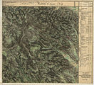
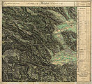
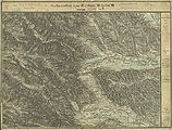
- Bad Gams and its surroundings in the three regional recordings from approx. 1789 to 1910

Gamsgebirg, Gams und Furth in the Josephinische Landesaufnahme , around 1780
The north of Gams and Furth in the Franziszeische Landesaufnahme , approx. 1835
Niedergams north of the Laßnitz valley

In the north are Vochera and the Stainztal, record sheet of the state record from 1877/78
Furth and Niedergams form the south of the municipality

In the francisco-josephine land survey , approx. 1910


Individual evidence
- ^ Styrian municipal structural reform .
- ↑ Section 3, Paragraph 2, Item 1 of the Act of December 17, 2013 on the reorganization of the municipalities of the State of Styria ( Styrian Municipal Structural Reform Act - StGsrG). Provincial Law Gazette for Styria of April 2, 2014. No. 31, year 2014. ZDB -ID 705127-x . P. 2.
- ^ Weekly newspaper Weststeirische Rundschau. November 22, 2013. Volume 86, No. 47. ZDB ID 2303595-X . Page 3.
- ↑ 248. Newsletter of the municipality of Deutschlandsberg from November 26, 2013.
- ↑ Peter Beck-Mannagetta, Martin Kirchmayer: The quartz , mica and feldspar grain structures in the eight plate gneiss complexes of the Koralpe. In: Yearbook of the Federal Geological Institute . Volume 131 Issue 4. Vienna year 1988. Pages 505–532 (PDF; 2.2 MB) graphic representation: Page 506.
- ↑ Peter Beck-Mannagetta : On the tectonics of the Stainzer and Gamser slab gneiss in the Koralpe (Styria). Yearbook of the Federal Geological Institute . 90th year, Vienna. 1945. Pages 151-180 digitized
- ↑ G (ernot) Weissensteiner: Minerals of the Koralpe . 1. Special volume of the club magazine Die Eisenblüte . Association of Styrian Mineral Collectors, Graz 1979.
- ↑ Gernot Weissensteiner: Mineral finds from the "Hohen Lassnitz", Koralpe. In: The Styrian Mineralogist. Collector's magazine for mineralogy and paleontology. Published by the Association of Styrian Mineral Collectors - VStM Graz. Year 10/2000, issue 14. Pages 9-14.
- ^ Weekly newspaper Weststeirische Rundschau . No. 50 of December 17, 2010. Volume 83, 2010. Page 1.
- ↑ Styrian municipal code in the version of the amendment in the State Law Gazette No. 92, issued on September 4, 2008, issue 27, page 304 in conjunction with Section 2, Paragraph 1 of the Styrian. Municipal Association Organization Act (GVOG) 1997.
- ↑ Michael Brandl: Silex deposits in Styria. Austrian Academy of Sciences OeAW, Philosophical-Historical Class, Announcements of the Prehistoric Commission Volume 69. Presented at the meeting on June 20, 2008. Verlag der OeAW Vienna 2009. ISBN 978-3-7001-6489-0 , ISSN 0065-5376 . Pages 59–61, picture on page 72.
- ^ Rupert Pitter: Wildbach: History of a West Styrian noble farm. In: Blätter für Heimatkunde BlHK. Volume 8, year 1930. p. 14.
- ↑ Sal ( Old High German sala). In: Jakob and Wilhelm Grimm : German dictionary . Volume 14 R-skewness. Leipzig 1893, column 1678, line 42. Reprint from Deutscher Taschenbuch Verlag . Munich 1991, ISBN 3-423-05945-1 . dtv 5945. Structure quoted from: The digital Grimm - Electronic edition of the first processing . Version 12/04. Two thousand and one, Frankfurt am Main, ISBN 3-86150-628-9 . Competence center for electronic cataloging and publication processes in the humanities at the University of Trier in conjunction with the Berlin-Brandenburg Academy of Sciences.
- ^ Sal- , In: Joseph von Zahn: Place names of Styria in the Middle Ages. Vienna 1893, Hölder publishing house.
- ↑ Werner Murgg, Bernhard Hebert: Medieval and early modern fortifications in the district of Deutschlandsberg: recording of the soil monuments. With drawings by Stefan Karl. Contributions to medieval archeology in Austria BMÖ. Volume 10, born in 1994. Ed .: Austrian Society for Medieval Archeology ÖGM, Vienna. ISSN 1011-0062 . Pp. 62-63. Land 246/1 and 246/10 KG 61213 Greim 46 ° 52 ′ 2 ″ N , 15 ° 12 ′ 20 ″ O
- ^ Robert Baravalle: Castles and palaces of Styria. An encyclopaedic collection of the Styrian fortifications and properties, which were endowed with various privileges. Graz 1961, Stiasny publishing house. P. 68.
-
^ Herwig Ebner: Castles and palaces in Styria. Part III. Graz, Leibnitz, West Styria. 2nd edition Vienna 1981 (1st edition 1967). S. 89.
Rupert Pittner: The noble farms around Gams. Greimbauer. In: Leaves on local history in Styria. BHKSt Volume 9, year 1931. pp. 7–16. - ^ Murgg, Hebert: Wehrbauten , p. 87 (sketch of the location).
- ↑ a b Robert Baravalle: Castles and palaces of Styria. An encyclopaedic collection of the Styrian fortifications and properties, which were endowed with various privileges. Graz 1961, Stiasny publishing house. Pp. 80-81.
- ↑ Rupert Pittner: The noble farms around Gams III. The Pramerhof in Gersdorf. In: Leaves on local history in Styria. BHKSt Volume 9, year 1931. pp. 77–85.
- ↑ a b area of the land 318/1, 318/2 61209 KG Gersdorf 46 ° 51 '31 " N , 15 ° 14' 27" O : Murgg, Hebert: fortifications , S. 68th
- ^ The Pramer and their West Styrian Gülten, article on the site of the Preding community.
- ↑ Franz Pichler: The Styrian Hebalmen. In: Gerald Schöpfer (Ed.): People, coins, markets. Catalog of the Styrian State Exhibition Judenburg 1989. ISBN 3-900662-16-9 . P. 78.
- ^ Anton Mell: High and lower criminal jurisdictions. Regional courts and truces in Styria. In: Anton Mell, Hans Pirchegger: Styrian court descriptions . As sources for the Historical Atlas of the Austrian Alpine Countries. I. Department. District court map: Styria. In the series: Sources on the constitutional and administrative history of Styria. I. Volume. Published by the Historical State Commission for Styria. Graz 1914. General: Pages XX – XLIV. Page 233 .
- ^ Mell: Criminal Courts , Page XXVI.
- ↑ Manfred Straka: Administrative boundaries and population development in Styria 1770-1850. Explanations for the first delivery of the Historical Atlas of Styria. Research on the historical regional studies of Styria, XXXI. Tape. Published by the Historical Commission for Styria - HLK. Self-published by HLK. Graz 1978. page 204 (WB Stainz) and page 212 (WB Wildbach)
- ^ Manfred Straka: Numbering sections and advertising districts of Styria 1779/81. Maps on a scale of 1: 300,000. In: Historical Atlas of Styria . Published by the Historical Commission for Styria - HLK. Academic printing and publishing company . Graz 1977 1st delivery: Administrative boundaries and population development in Styria 1770–1850. Sheet 2 (sheet north).
- ^ Manfred Straka: Tax communities and advertising districts of Styria 1798–1810. Maps on a scale of 1: 300,000. In: Historical Atlas of Styria . Published by the Historical Commission for Styria - HLK. Academic printing and publishing company. Graz 1977. 1st delivery: Administrative boundaries and population development in Styria 1770–1850. Sheet 4 (sheet north)
- ^ Manfred Straka: cadastral communities and advertising districts of Styria 1818–1848. Maps on a scale of 1: 300,000. In: Historical Atlas of Styria . Published by the Historical Commission for Styria - HLK. Academic printing and publishing company. Graz 1977. 1st delivery: Administrative boundaries and population development in Styria 1770–1850. Sheet 6 (sheet north).
- ↑ Gerald M. Wolf: "Now we are the gentlemen ..." The NSDAP in the Deutschlandsberg district and the July Putsch 1934 (= Grazer Zeitgeschichtliche Studien, Volume 3) StudienVerlag, Innsbruck-Vienna-Bozen 2008, pages 155–156 and 183 ( Death list). ISBN 978-3-7065-4006-3 .
- ^ Siegfried Beer, Stefan Karner: The war from the air: Carinthia and Styria 1941–1945. Graz 1992. Weishaupt Verlag, ISBN 3-900310-38-6 , p. 347.
- ↑ Announcement of the kk governor in Styria of April 2, 1908 regarding the most highly approved state parliament resolution of September 26, 1907 due to the separation of the local community of Gams into the local communities of Feldbaum and Gams, State Law and Ordinance Gazette for the Duchy of Styria of April 16, 1908, X. Piece, No. 36, p. 83.
- ^ Ordinance of August 21, 1947 , State Law Gazette for Styria of September 3, 1947, Issue 17, No. 31, p. 78.
- ↑ Law of December 18, 1967 on territorial changes of municipalities , Provincial Law Gazette for Styria of December 29, 1967, Part 26, No. 138, p. 188.
- ^ Ordinance of February 5, 1948 , Provincial Law Gazette for Styria of April 15, 1948, 6th issue , No. 21. P. 49.
- ↑ Announcement of May 16, 1951 , State Law Gazette for Styria of December 28, 1959, Issue 13, No. 37, p. 114.
- ↑ Announcement of December 3, 1973 , State Law Gazette for Styria of December 27, 1973, Issue 28, No. 151, p. 206.
- ↑ Announcement of May 30, 1980 , State Law Gazette for Styria of June 19, 1980, 8th issue, No. 39. pp. 37-38.
- ^ Oskar Veselsky: The consecration reports from the ordination and consecration protocols of the bishops of Lavant in the 16th century. In: Sources for the historical regional studies of Styria, published by the Historical Commission for Styria - HLK, XI. Tape. Graz 1997. Self-published by HLK. No ISBN. Pages 62 and 80.
- ^ Rupert Pitter: Wildbach. P. 26.
- ^ Oskar Veselsky: Lavanter ordination and consecration reports from 1586 to 1679. In: Sources for the historical regional studies of Styria, published by the Historical Commission for Styria - HLK, 22nd volume. Graz 2008. Self-published by the HLK. ISBN 978-3-901251-21-4 , page 303.
- ↑ See: Adolf A. Osterider, Alfred Seebacher-Mesaritsch : Bad Gams. History and landscape. 2nd Edition. Leykam, Graz 1989
- ↑ a b District Topography: Second Part, District Lexicon. Pages 19-25.
- ^ Kurt Woisetschläger, Peter Krenn: Dehio manual. The art monuments of Austria. Styria (excluding Graz). Topographical inventory of monuments, published by the Federal Monuments Office. Vienna 1982, ISBN 3-7031-0532-1 , page 133.
- ↑ Gerhard Fischer: The Catholic Church in Styria is breaking new ground. Merger of the dean's offices in Deutschlandsberg and Leibnitz to form the South-West Styria region. Weekly newspaper Weststeirische Rundschau from August 31, 2018. Volume 91, No. 35, p. 2.
- ↑ Decision of the district authority of Deutschlandsberg of October 3, 1977, reference number 6 G 4/77. Object no. 477. Digital Atlas Styria ( page no longer available , search in web archives ) Info: The link was automatically marked as defective. Please check the link according to the instructions and then remove this notice. Map service: flora & fauna, natural protected areas, natural monuments - if you hold down the left mouse button, enlarge the area by dragging. The information can be called up with "Identify object" (button "i"), and in the window that opens, look for "Natural monuments". Retrieved March 5, 2011.
- ↑ Land register, district court Stainz, cadastral community 61235 Sallegg, deposit number 76, property number 1/2.
- ↑ Landscape protection area 2: Ordinance of the Styrian state government of May 25, 1981, stmk. State Law Gazette No. 37/1981 in the version of the correction (new map display) No. 64/1981. Map of the protected area ( page no longer available , search in web archives ) Info: The link was automatically marked as defective. Please check the link according to the instructions and then remove this notice. in the Digital Atlas Styria. Before that, protection existed under the ordinance of June 12, 1956, LGBl. No. 35, for the protection of parts of the landscape and the landscape (Landscape Protection Ordinance 1956) in the version of the ordinances LGBl. No. 57/1958, 125/1961, 185/1969, 96/1970, 14/1974, 147/1974 and 30/1975, with regard to Annex 1 Z 2.
- ↑ Bad Gams vineyard control center at outdooractive.com

Bad Schwanberg | Deutschlandsberg | Eibiswald | Frauental an der Laßnitz | Great Saint Florian | Lannach | Pölfing-Brunn | Preding | Sankt Josef (West Styria) | Sankt Martin im Sulmtal | Sankt Peter im Sulmtal | Sankt Stefan ob Stainz | Stainz | Wettmannstätten | Wies
93 Former communities (dissolved since 1945):
Aibl |
Aigen |
Bad Gams |
Blumegg |
Breitenbach in West Styria |
Dietmannsdorf im Sulmtal |
Ettendorf near Stainz |
Feisternitz |
Field tree |
Freidorf an der Laßnitz |
Open field near Deutschlandsberg |
Gamsgebirge |
Garanas |
Gasselsdorf |
Georgsberg |
Gersdorf |
Grafendorf near Stainz |
Graggerer |
Grass shoe |
Greisdorf |
Greith |
Gressenberg |
Großradl |
Grub near Groß Sankt Florian |
Grünau an der Laßnitz |
Gundersdorf |
Gussendorf |
Hasreith |
Herbersdorf |
Hollenegg |
Kleinradl |
Monastery |
Kornriegl |
Kothvogel |
Kraubath (West Styria) |
Krottendorf an der Laßnitz |
Kruckenberg |
Laaken |
Lasselsdorf |
Lebing |
Limberg near Wies |
Mainsdorf |
Marhof |
Mettersdorf |
Michlgleinz |
Nassau |
Neudorf near Stainz |
Neurath |
Niedergams |
Oberhart |
Upper Latin |
Oisnitz |
Osterwitz |
Otternitz |
Petzelsdorf in West Styria |
Pichling at Stainz |
Pirkhof |
Pitschgau |
Rassach |
Rossegg |
Rostock |
Red wine |
Sankt Oswald ob Eibiswald |
Sankt Ulrich in Greith |
Schönaich |
Sierling |
Soboth |
Stainztal |
Stable yard |
Stammeregg |
Sterglegg |
Sulmeck-Greith |
Sulz |
Sulz-Laufenegg |
Tanzelsdorf |
Teipl |
Tobis |
Tobisegg |
Trahütten |
Trough |
Unterbergla |
Vochera am Weinberg |
Vochera an der Laßnitz |
Front village |
Forest in West Styria |
Wernersdorf |
Wetzelsdorf in West Styria |
Wielfresen |
Wieselsdorf |
Torrent |
Wohlsdorf |
Zeierling |
Zirknitz