
Marhof

Marhof is a place in western Styria in Austria. Until the end of 2014, it was a municipality with 1,048 inhabitants (as of October 31, 2013) in the Deutschlandsberg district ( Deutschlandsberg judicial district ) in Styria . As part of the structural reform of the Styrian community , Marhof was merged with the communities of Stainz , Stallhof , Stainztal , Rassach and Georgsberg from 2015 , the new community continues the name Stainz. The basis for this is the Styrian Municipal Structural Reform Act - StGsrG.
geography
location
Marhof consists of four cadastral communities. The most important streams are the Theussenbach, the Sierlingbach and the Rainbach, all of which flow into the largest creek in the area, the Stainzbach . Important elevations are the Rosenkogel ( 1362 m ), Mothiltor ( 1240 m ) and the Reinischkogel ( 1463 m ) in the border area to the monastery and Edelschrott . The rocks on which Marhof lies belong to the Koralm crystalline and have been scientifically examined in detail.
Neighboring places
| Greisdorf | St. Stefan ob Stainz | |
|
Monastery / precious scrap |
.svg)
|
Georgsberg |
| Bad Gams | Stainz |
history
The first individual finds in the municipality are from Roman times , when the Noriker , a Celtic tribe, settled here. Archaeological excavations at the Sporiroa furnace have found finds from the late Lasinja culture and the time around 1100 AD. It is possible that the medicinal spring of today's Bad Sauerbrunn in the west of Marhof was already used by the Romans.
In the 13th century , Wessenstein Castle was built northwest of Marhof above the Sauerbrunn and Theußenbach trenches . It was first mentioned in a document in 1245 . The castle protected the way from Stainz via Herzogberg (Aiblwirt) or between Rosen- and Reinischkogel (Absetzwirt) to the Pack or the Hebalm and to Carinthia. The first written mention of Marhof comes from the year 1411 , when there was a report about the "Maierhoif in S.Stephans pharr ob Stencz".
There is a short story by Peter Rosegger about the mineral springs and the mining of Stainzer plates near Marhof . Their (initially unrecognized) discovery is said to be due to information given by an old woman to the miller of the (now dilapidated) Sommermichelmühle in thanks for giving her a measure (approx. 1.4 l) of rye flour; the dismantling of the Stainzer panels, which can be used as building material, is said to have made the miller rich later.
From 1870 to 1935, the well-known miracle healer Johann Reinbacher, commonly known as Höllerhansl, lived in Rachling, in what is now the municipality (then still the municipality of Sierling) .

The municipality of Marhof was created on January 1, 1968 by merging the previously independent municipalities of Sierling and Trog and part of the former municipality of Wald in West Styria (districts of Wald, Preisberg, Grünbaumgarten and Schönegg), and existed in this form until 2014. The name of the The municipality of Wald was changed to Wald in West Styria on June 1, 1951 .
Weaning host
The name "Absetzwirt" between Rosenkogel and Reinischkogel in the west of Marhof on the border with Gams is evidence of the "setting down" (unloading) of (load) loads. The Abetzwirt was a place where load transports took a break or where loads were transferred from one means of transport to another. This is because not all carters were allowed to leave the area of their manorial rule and therefore transports to borders had to be handed over to other transporters.
population
Population structure
According to the 2001 census, Marhof had 1,063 inhabitants. 99.0% of the population had Austrian citizenship. 91.6% of the population professed to be part of the Roman Catholic Church , 4.5% were without religious beliefs.
Population development
The population of Marhof remained relatively constant for a long time. Since 1971, however, the population has been moving slightly downwards.

Economy and Infrastructure
According to the 2001 census of workplaces , there were 31 workplaces with 140 employees in Marhof as well as 377 out-commuters and 74 in-commuters. There are 115 agricultural and forestry holdings (21 of which are the main occupation), which together cultivate 1,577 hectares (1999).
The access to traffic takes place via the state road L 684, which connects the community via Stainz to the Radlpas road B 76.
politics
Municipal council
In the municipal council elections in 2005, the SPÖ was able to wrest the supremacy of the ÖVP in Marhof, profiting greatly from the ÖVP's losses and the votes of the FPÖ , which no longer took part. A plus of 20.62% meant a total of 63.90% and the acquisition of three mandates. The ÖVP, however, shrank by 12.50% to 36.10%, which meant a loss of two mandates.
coat of arms
The right to use the municipal coat of arms was granted to the then municipality of Marhof on June 16, 2002. The design comes from Gernot Obersteiner from the Styrian State Archives. In the lower area of the coat of arms, it shows a blue, silver-flooded shield base, which symbolizes the healing spring of Bad Sauerbrunn . Above it are tinned, green and silver-bordered rafters , which stand for the former Wessenstein Castle (see history). From the upper rafter, two silver roses grow on a red background , symbolizing the Rosenkogel . The six rose petals on the branches stand for the six localities of the municipality: Angenofen , Rainbach, Sierling, Teufenbach, Trog and Wald in western Styria.
Culture and sights
See also: List of listed objects in Stainz
Web links
- Marhof in the municipal network
- www.schilcherland.com
- Statistical data on the former municipality (click on the individual lines on the linked page)
Individual evidence
- ↑ State of Styria: Final population status on October 31, 2013 ( Memento of the original from April 15, 2015 in the Internet Archive ) Info: The archive link was inserted automatically and has not yet been checked. Please check the original and archive link according to the instructions and then remove this notice. (Excel file, 85 kB; accessed on May 2, 2015)
- ^ Styrian municipal structural reform .
- ↑ Section 3, Paragraph 2, Item 5 of the Act of December 17, 2013 on the reorganization of the municipalities of the State of Styria ( Styrian Municipal Reform Act - StGsrG). Provincial Law Gazette for Styria of April 2, 2014. No. 31, year 2014. ZDB -ID 705127-x . P. 2.
- ↑ Peter Beck-Mannagetta: On the tectonics of the Stainzer and Gamser slab gneiss in the Koralpe (Styria). Yearbook of the Federal Geological Institute . 90th year, Vienna. 1945. Pages 151-180 ( PDF ).
- ↑ Ulla Steinklauber: Finds from the "Sporiroaofen" in West Styria . Find reports from Austria. Published by the Federal Monuments Office. Volume 42, year 2003. Vienna 2004. Pages 417–422.
- ↑ On the Rosegger year 2018 . In: Weststeirische Rundschau . No. 30, Volume 2018 (July 27, 2018), 91st Volume. ZDB -ID 2303595-X . Simadruck Aigner u. Weisi, Deutschlandsberg 2018, p. 7, with reference to the publication of the story Der Steinhansel in Tagespost No. 196, XIX. Vintage. August 29, 1874. pp. 1-2.
- ↑ Bernd E. Mader: The Höllerhansl. Life and work of the naturopath Johann Reinbacher. Graz-Vienna 1997. Styria. ISBN 3-222-12607-0 .
- ↑ Law of December 18, 1967 on territorial changes of municipalities , Provincial Law Gazette for Styria of December 29, 1967, Part 26, No. 138, p. 188.
- ↑ Announcement of May 16, 1951 , State Law Gazette for Styria of December 28, 1959, Issue 13, No. 37, p. 114.
- ↑ Franz Pichler: The Styrian Hebalmen. In: Gerald Schöpfer (Ed.): People, coins, markets. Catalog of the Styrian State Exhibition Judenburg 1989. ISBN 3-900-662-16-9 . P. 78.
Historical maps
- The area of Marhof and its surroundings in the three regional surveys in the period from approx. 1789 to 1910
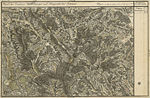
The area north of Marhof in the Josephinische Landesaufnahme , approx. 1789

Marhof as Meyerhof in the Stainztal
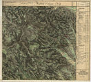
Marhof in the Franziszeische Landesaufnahme , approx. 1835
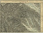
Marhof with Stainz, the Rosenkogel and the Reinischkogel, recording sheet 1: 25,000 of the Franzisco-Josephinische Landesaufnahme , around 1878
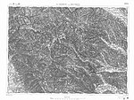
In the francisco-josephine land survey , approx. 1910


Bad Schwanberg | Deutschlandsberg | Eibiswald | Frauental an der Laßnitz | Great Saint Florian | Lannach | Pölfing-Brunn | Preding | Sankt Josef (West Styria) | Sankt Martin im Sulmtal | Sankt Peter im Sulmtal | Sankt Stefan ob Stainz | Stainz | Wettmannstätten | Wies
93 Former communities (dissolved since 1945):
Aibl |
Aigen |
Bad Gams |
Blumegg |
Breitenbach in West Styria |
Dietmannsdorf im Sulmtal |
Ettendorf near Stainz |
Feisternitz |
Field tree |
Freidorf an der Laßnitz |
Open field near Deutschlandsberg |
Gamsgebirge |
Garanas |
Gasselsdorf |
Georgsberg |
Gersdorf |
Grafendorf near Stainz |
Graggerer |
Grass shoe |
Greisdorf |
Greith |
Gressenberg |
Großradl |
Grub near Groß Sankt Florian |
Grünau an der Laßnitz |
Gundersdorf |
Gussendorf |
Hasreith |
Herbersdorf |
Hollenegg |
Kleinradl |
Monastery |
Kornriegl |
Kothvogel |
Kraubath (West Styria) |
Krottendorf an der Laßnitz |
Kruckenberg |
Laaken |
Lasselsdorf |
Lebing |
Limberg near Wies |
Mainsdorf |
Marhof |
Mettersdorf |
Michlgleinz |
Nassau |
Neudorf near Stainz |
Neurath |
Niedergams |
Oberhart |
Upper Latin |
Oisnitz |
Osterwitz |
Otternitz |
Petzelsdorf in West Styria |
Pichling at Stainz |
Pirkhof |
Pitschgau |
Rassach |
Rossegg |
Rostock |
Red wine |
Sankt Oswald ob Eibiswald |
Sankt Ulrich in Greith |
Schönaich |
Sierling |
Soboth |
Stainztal |
Stable yard |
Stammeregg |
Sterglegg |
Sulmeck-Greith |
Sulz |
Sulz-Laufenegg |
Tanzelsdorf |
Teipl |
Tobis |
Tobisegg |
Trahütten |
Trough |
Unterbergla |
Vochera am Weinberg |
Vochera an der Laßnitz |
Front village |
Forest in West Styria |
Wernersdorf |
Wetzelsdorf in West Styria |
Wielfresen |
Wieselsdorf |
Torrent |
Wohlsdorf |
Zeierling |
Zirknitz
Coordinates: 46 ° 54 ' N , 15 ° 13' E