
Angenofen
Coordinates: 46 ° 54 ' N , 15 ° 12' O In the furnace is a bei Marhof (Stainz) and is located approximately 700 meters above the sea above Stainz . From Angenofen you can see the Graz Basin and Stainz. The Göri Chapel is located in the village.
The name of the place contains a reference to the geology of the area: Slab gneiss forms individually towering small rock formations in the area, which are up to 20 m high and are known as "ovens" . “Oven” is (next to the fireplace) a name for more or less jagged rocks or rubble that do not form mountains or other distinctive shapes. The word occurs frequently on the Kor and Saualpe, cf. Bärofen, Großofen on the Koralpe, Mannagetta furnace and Schrattelofen near Stainz and can also be found in other areas.
Angenofen is an old settlement area. In the cadastral community of Sierling in the northeast of the village on both sides of the Suchyweg, a junction of the Angenofnerweg, a reference to the settlement history was still in the 21st century: the "Angenofner Bauerngmein". Their land was jointly owned by the seven owners of several (partly former) farms. The ownership shares were not assigned to persons in the land register, but rather linked to the ownership of the properties of these farms (the so-called “master properties” in the land register). This distribution of ownership is based on documents from 1874. The name is evidence that these areas are remnants of a village common property ( common property ), such areas were referred to in Bavarian usage as "G (e) mein". They existed in many places that arose in the 12th or 13th century and are indications of a planned settlement of an area, the framework conditions of which were determined by an authority. From the late Middle Ages, however, these communal areas were mostly divided up among those entitled due to discrepancies or their area was assigned to new farms (chaste, Huben). This also proves the relatively small size of the properties recently. A regulatory procedure was carried out through the Bauerngmein in Angenofen and concluded in 2017.
38 houses with comfortable accommodation for twelve men: Angenofen in the Franziszeische Landesaufnahme, approx. 1835

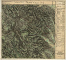
Angenofen west of Stainz in the recording sheet of the 3rd regional survey around 1878

"Ankenofen" in the Josephinische Landesaufnahme, approx. 1780
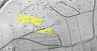
Angenofner Bauerngmein 2017


Individual evidence
- ↑ Jakob and Wilhelm Grimm: German Dictionary . Volume 13 N-Quurren. Leipzig 1889. Keyword “oven” point 6). Column 1158, line 21: The word is treated there for the Bavarian-Austrian mountain mouth as common Germanic for rock cave, fissured rock, jumbled rock debris (roots as far as Sanskrit ).
- ↑ District Court of Deutschlandsberg (formerly: Stainz). Land register of the cadastral community 61238 Sierling, deposit number 1, 5440 m².
- ↑ Walter Brunner: The Gmein in the Styrian Altsiedelland. In: Gerhard Pferschy: settlement, power and economy. Festschrift Fritz Posch for his 70th birthday. Publications of the Styrian regional archive. Volume 12. Graz 1982. No ISBN. Pages 45-50.
- ↑ Announcement of the agricultural district authority for Styria dated March 24, 2017 on the initiation of the procedure regarding the regulation of the agricultural community "Angenofner Bauerngmein". Grazer Zeitung, Official Gazette for Styria. 13th issue, issued March 31, 2017. Volume 213, Graz 2017. ZDB -ID 1291268-2 p. 155.
- ↑ Announcement of the agricultural district authority for Styria from July 5, 2017 on the conclusion of the procedure regarding the regulation of the agricultural community "Angenofner Bauerngmein". Grazer Zeitung, July 14, 2017. p. 338.