
Josephine land survey

The Josephinische Landesaufnahme , also known as the first land survey , is the first comprehensive map project (land survey) in the territory of the Habsburg Monarchy from the 1760s to the 1780s . It is named after the Archduke of Austria and Roman-German Emperor Joseph II .
The 3,589 hand-drawn colored map sheets (later expanded to 4,096 sections) encompass the Habsburg hereditary lands ; they are kept in the war archive of the Austrian State Archives.


Origin and scope
Military considerations gave the impetus for taking up the country. During the Seven Years' War from 1756 to 1763, the lack of reliable maps had proven to be a major disadvantage for the Austrian troops . Field Marshal Daun suggested to Maria Theresa in 1764 that officers of the General Staff (General Quartermaster Staff) map their countries . In the time before, the creation of maps was the matter of private landowners who had relevant maps made to document their property. On May 13, 1764, after approval by the Empress, the Court War Council issued appropriate orders for a first comprehensive survey of the country. Work started in Bohemia and Moravia .
The Josephinische Landesaufnahme was started under the reign of Maria Theresa and completed under Joseph II . The maps are hand-drawn and initially had a scale of 1 Viennese customs : 400 Viennese fathoms (approx. 1: 28,800). Only the ad hoc level marks the height of development over the surface to represent were hatching that trace the local slope and direction of the fall line, used and not contour lines . Maps on a four-fold reduced scale of approx. 1: 115,200 were derived from the sheets of the land survey. These sheets are also referred to as "Josephinische Landesaufnahme".
The Carte des environs de Schönbrun et ceux de Laxemburg of the south-west of Vienna from 1755 is considered a forerunner of the Josephinische Landesaufnahme. The author of this map was Jean-Baptiste Brequin de Demenge .
The Josephinische Landesaufnahme ultimately comprised over 4,000 sheets from the years 1763 to 1785. The following Habsburg regions were recorded in detail:
| region | year | Overview |
|---|---|---|
| Duchy of Upper Silesia | 1763 |

|
| Kingdom of Bohemia | 1764-1767 |

|
| Margraviate of Moravia | 1764-1768 |

|
| Netherlands | 1764-1771 |

|
| Temescher Banat | 1769-1772 |

|
| Grand Duchy of Transylvania | 1769-1773 |

|
| Banal limit | 1773-1775 |

|
| Bukovina district | 1773-1776 |

|
| Austria under the Enns | 1773-1781 |

|
| Karlstadt Generalate | 1774-1775 |

|
| Upper Austria with the Innviertel | 1775-1777 and 1779-1780 |

|
| Galicia and Lodomeria | 1779-1783 |

|
| Slavonian military border | 1780 |

|
| Wallachian-Illyrian Banat Military Regiment | 1780-1784 |
|
| German Banat Military Regiment | 1769-1772 |
|
| Warasdin Generalate | 1781-1782 |

|
| Slavonia Province | 1781-1783 |

|
| Kingdom of Hungary | 1782-1785 |

|
| Province of Croatia | 1783-1784 |

|
| Inner Austria | 1784-1785 |

|
Tyrol was initially excluded, as the Atlas Tyrolensis map series on a scale of 1: 103.800 by Peter Anich and Blasius Hueber had been available since 1774 . The exact recording of Tyrol, begun in 1803, remained unfinished and had to be broken off in 1806 due to the French-Bavarian occupation.
Further single sheets were produced by 1806, which also covered areas from southwest Germany and smaller parts of Switzerland, France and Venice.
The land survey originally only existed in two copies, one each for the emperor and the supreme general. It was kept secret. The sheets are - depending on the commitment of the employees - of different graphic, but also technical quality. The individual sheets do not have a uniform measurement basis (no triangulation ) and can therefore not easily be combined into larger units.
The maps of the Josephinische Landesaufnahme are accessible in the Austrian State Archives / War Archives .
The Josephinische Landesaufnahme was then replaced from 1807 by the Franziszeische (2nd) Landesaufnahme .
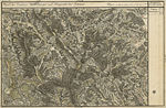
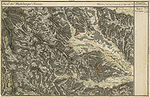
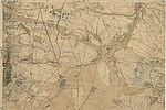
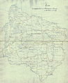
Examples of sheets of the Josephinische Landesaufnahme

Northern Lavanttal and Preitenegg in the west of the Koralm
Hebalm with Schröfelsee (bottom left) and Klosterwinkel (bottom center)

Kainachtal near Mooskirchen and Lannach , Grazer Feld southwest of Graz

Schwarzkogelzug northwest of Deutschlandsberg with Ostrowitz , St. Oswald in Freiland , Trahütten and Freiland
Schwanberg and the surrounding area
Vienna Basin south of Vienna ( Liesing , Laxenburg , Mödling )

Kingdom of Hungary (plan)
Temescher Banat , (1718–1778)

Transylvania , (1769–1773)


See also
- List of map series
- Franziszeische Landesaufnahme
- Franzisco-Josephinische Landaufnahme
- Franziszeischer Cadastre
- Fourth land recording
- Austro-Hungarian country recordings
- Carte des environs de Schönbrun et ceux de Laxemburg
literature
- Ernst Hillbrand: The map collection of the Vienna War Archives. In: Communications from the Austrian State Archives 28/1975. Pages 183-196.
- Ernst Hofstätter: Contributions to the history of the Austrian regional recordings. An overview of the topographical recording procedures, their origins, their developments and organizational forms of the four Austrian regional surveys. 2 volumes. Federal Office for Metrology and Surveying, Vienna 1989.
- Robert Rill: The beginnings of military cartography in the Habsburg hereditary lands: The Josephinian land survey of Bohemia and Moravia according to court war council sources. In: Communications from the Austrian State Archives. Volume 49/2001. Pages 183-202.
Regional:
- Wilfried Beimrohr, Tyrolean State Archives: Special Map Tyrol, Vorarlberg and Liechtenstein 1823 . 2006 - Information sheet on the Josephinian and Franziszeische land recordings and on the special map of the princes of Tyrol, together with Vorarlberg and the neighboring Sovereign Principality of Liechtenstein, measured trigonometrically, topographically recorded, reduced and drawn in 1823 ( pdf , tirol.gv.at)
- Vincenc Rajšp (project leader): Slovenija na vojaškem zemljevidu 1763 - 1787 Opisi . 7 volumes. Ljubljana 1995-2001. (Josephine land survey 1763–1787 for the territory of the Republic of Slovenia, country description)
- Zdzisław Budzyński, Waldemar Bukowski, Bogusław Dybaś, Andrzej Janeczek, Zdzisław Noga (editorial board): The Josephine Land Map of Galicia 1779 - 1783. 15 volumes. Vienna 2012 – ongoing (Josephinische Landaufnahme for the historical region Galicia, country description).
Web links
Tickets online:
- mapire.eu : The country recordings in easy-to-use digital form
- various Austrian provincial GIS: Historical maps of Tyrol (TIRIS)
- oldmaps.geolab.cz , University of Ústí: Maps of the first land survey for the area of Bohemia, Moravia and Silesia
- kbr.be : Territory of the Austrian Netherlands
Individual evidence
- ↑ Wilfried In the tube: The First and Second land survey of Tyrol. Tyrolean State Archives, 2007 (pdf, tirol.gv.at).
- ↑ Austrian State Archives. Archive plan context. Card collection. Signature AT-OeStA / KA KPS KS ( archiving history , archivinformationssystem.at).