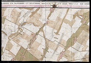
Carte des environs de Schönbrun et ceux de Laxemburg
The Carte des environs de Schönbrun et ceux de Laxemburg is a map from the year 1755. It was founded by de Jean-Baptiste Brequin Demenge by order of Emperor Franz Stephan created and is the area between Schonbrunn Palace and Laxenburg in the southwest and south of Vienna from .
Surname
The full name of the card is " Carte des environs de Schönbrun et ceux de Laxemburg, levée en Novembre et Décembre MDCCLIV et Avril MDCCLV par ordre de sa majesté imperiale et royale ".
Translated, the title means: " Map of the area around Schönbrunn and that of Laxemburg, taken from November to December 1754 and April 1755 on behalf of His Imperial and Royal Majesty "
General
Their representation goes far beyond the direct connection between Schönbrunn and Laxenburg. It begins in the north-west of Vienna near Nussdorf and extends on the western edge of the Vienna basin via the western and south-western suburbs of Währing , Ottakring , Hütteldorf , Meidling , Speising , Lainz , Mauer , Atzgersdorf , Vösendorf , Inzersdorf and Liesing on to Perchtoldsdorf , Mödling to Traiskirchen , Münchendorf and Möllersdorf . The area of the City of Vienna in its former borders (within the line wall) is not shown, however, the corresponding area has been left blank. Only the Stephansturm and Belvedere are listed.
The map originally belonged to the inventory of the map department of the Albertina and came from there to the map collection of the Austrian National Library . Like large-format maps at the time, it was little known until the 20th century due to the lack of good reproduction possibilities. In 1936 it was presented as "previously unknown". In 1980 she is not mentioned in the catalog of the exhibition on the 200th anniversary of Maria Theresa's death .
The card is 2.22 m long and 1.1 m wide. It consists of six sheets and was initially cut differently, which can be seen from the glued dividing points.
It is roughly 1 inch = 150 fathoms , with distortions due to the drawing and measuring methods of the time, but also due to the paper, and the map itself contains slightly different scale specifications (the scale in the top gives 18 fathoms for 1000 fathoms) , 4 cm, the one in the lower part for 1000 fathoms 17.6 cm). The differences in this information are attributed to the fact that different fathoms were used (fortification fathoms of 1.94918 m, Viennese fathoms of 1.8965 m, further as mentioned on the map itself, Toises ). The scale corresponds to about 1: 10,800.
It was discussed whether (at least) two copies of the map would not have been drawn, because the surviving copy does not contain any graphic decoration other than a frame and expects more ornamental drawings for a card that would be intended for the use of the imperial family would. Investigations in the Austrian State Archives did not reveal any further copies of the map. It is also conceivable that the map was actually only created in the existing original, which was primarily intended for the 14-year-old heir to the throne Joseph and whose wishes (or those of his tutors) should be simple but practical.
Trivia
The Carte des environs de Schönbrun et ceux de Laxemburg is seen as the forerunner of the four Austrian regional recordings. The first of these, the Josephinische Landesaufnahme , was started while Jean-Baptiste Brequin de Demenge was still alive .
Card cut
See also
- List of map series
- Josephine land survey
- Franziszeische Landesaufnahme
- Franziszeischer Cadastre
- Franzisco-Josephinische Landaufnahme
- Fourth land recording
- Austro-Hungarian country recordings
literature
- Ferdinand Opll : Maps as a source of topographical knowledge. The Liesinger area in the south of Vienna at the time of Maria Theresa. In: Viennese history sheets . Edited by the Association for the History of the City of Vienna . 68th year. Issue 2/2013. ISSN 0043-5317 ZDB -ID 2245-7 .
- Eugen Oberhummer : A map of the area around Vienna under Maria Theresa. In: Yearbook of the Association for Regional Studies of Lower Austria. Volume 26 (1936). ISSN 1016-2712 . ZDB ID 501694-0 . Pp. 158-161.
Web links
Individual evidence
- ↑ a b Oberhummer: Map . P. 158.
- ↑ Walter Koschatzky (concept and scientific management): Exhibition catalog “Maria Theresia and her time.” For the 200th anniversary of the death. Exhibition May 13 to October 26, 1980 Vienna, Schönbrunn Palace. Section 112 - Cartography and Topography. Residenz Verlag Salzburg 1980. pp. 481–485.
- ↑ Fidel von Baur: Handbook for Officers of the General Staff ... Cotta, 1840, p. 498 ( limited preview in Google Book search).
- ↑ Oberhummer: Map . P. 160. Calculation: 1 inch = 26.34 mm. 1 (Vienna) fathom = 1896.48384 mm. 150 fathoms = 284,472.576 mm, divided by 26.34 = 10,800.02187 (below the hundredth place exactly and irrelevant for the 18th century because of the line widths and paper movements of the hand-made paper at that time).
- ↑ Oberhummer: Map . P. 161.
- ^ Johanna Schönburg-Hartenstein / Renate Zedinger: Jean-Baptiste Brequin (1712–1785): A scientist from Lorraine in the service of the Viennese court. In: Research and contributions to the history of the city of Vienna. Publication series of the Association for the History of the City of Vienna, Volume 42. Verlag Deuticke Vienna 2004. ISBN 978-3-7005-4678-8 . ZDB ID 716753-2 . P. 35, with reference to: Ferdinand Opll: Vienna in the picture of historical maps. The development of the city until the middle of the 19th century . Plate 20. Böhlau Verlag Vienna 2004. ISBN 978-3-205-77240-8 . P. 49.


