
See Eben
The lake Eben is a wetland ( peat moss , moor ) in the middle Koralpe in the border area between western Styria and Carinthia . It is located in the south of the Hebalm .

geography
The lake Eben is around 5.7 hectares in size. It is located at 1440 m above sea level. A. , about 300 meters west of the Stoffhütte in the catchment area of the Stoffbach , about two kilometers southwest of the Hebalmstrasse (Rehbockhütte, Hebalmwirtshaus). The point is not developed, can only be reached on foot, in summer via the forest roads (which are largely closed to motor vehicles) to the fabric hut, in snow conditions with cross-country skiing equipment.
The location of the lake Eben on the ridge of the Koralpe is evidence of the clod-like structure of this mountain range: Geologically, the Koralpe is a raised part of the mountain, a so-called Pultscholle . The wetland is located on a relatively flat area several kilometers long, on which there are a number of wetlands (including the Filzmoos as the origin of the Rettenbach and Klosterbach ).
The See Eben is also the headwaters of the Schreflbach, a source of the Waldensteiner Bach, which flows into the Lavant near Wolfsberg , and several small channels that flow east into the Stoffbach in the Rettenbach and Laßnitz valleys . The moor thus forms the Drau – Mur watershed .
The north-south long-distance hiking trail leads a few hundred meters past the lake Eben at the Stoffhütte.
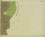
The See Eben is also called See Eben e on maps , which refers to the flat terrain. The name variant Seeboden in the Franziszeische Landesaufnahme approx. 1835 forms a similar reference, the word Boden means a flat surface (in contrast to the mountainous country, as with Kainachboden , (Aichfeld-) Murboden ).
The Carinthian part of the Lake Eben and the area to the west and north of it form the land register entry Konradöden , its owner is the Order of Malta . The area belongs to the forestry Hebalm of this order, it is accessible in winter by a cross-country ski run from the Hebalm ski area.
In the spring of 2008, a viewing platform was built north of Lake Eben, from which the area of the raised bog can be observed. This viewpoint can be reached from the Hebalm in about half an hour's hike, the starting point is the junction of the old wine route east of the Hebalm chapel.
Names

Deriving from a lake
The lake Eben is also called Seemoos . The name is taken as an indication that the area is a former lake.
In fact, in the See Eben there is, in addition to many other small bodies of water (Schlenken), a larger one, albeit only a few meters long. It doesn't have to be the rest of a silted-up, previously larger lake. The water surface can also be a high bog (bog eye ), which owes its existence to the growth of the bog and an excess of water, i.e. it was not present before the bog, but only arose with the bog.
The earlier name of the lake Eben as Schröfel-See refers to the small rocks and scree slopes ( Schrofen ) that can be found in the area.
Derivation from a transport station
The See Eben is located on an old road connection called the Wine Route and is still used today, for example as a long-distance hiking trail Lavanttaler Höhenweg . This connection runs from Frantschach-St. Gertraud in Lavanttal on the border between Carinthia and Styria on the Hebalm, it is already documented in the Josephinische Landesaufnahme. Its course north of the See Eben is also shown in the revision generations (revisions, map updates) of the newer official maps as a wide footpath or cart path. All these paths lead to the now uninhabited forester's house Hebalm or to the Hebalm chapel and thus document the former importance of this area. The existing Hebalmgasthaus (Rehbockhütte, Hebalmschutzhaus) is just under a kilometer to the east on other paths.

Until the middle of the 17th century, the paths over the Hebalm were part of a "network of wine routes" and important trade routes, for example for salt. One of these paths led from Deutschlandsberg via the former municipality of Kloster to the Hebalm and from there into the Lavant valley. Another road went from Gams via Greim to the Absetzwirt and from there to the Hebalm (Greimstrasse) .
The See Eben was thus on a locally important trade route. This path ran over the nearby Seeberg and is shown in the map relevant at the time in the same way as today's Hebalmstraße.
Up until the 19th century, anyone who undertook transports for places other than their own manorial power was not always allowed to drive across the manorial or state border. Other freighters were waiting at the borders to take care of the onward transport. Those places where, for example, wine and salt barrels were lifted from one cart to another, were called lifting points.
Names in Hebrew are reminiscent of the reloading (reloading) of these cargoes. With this situation the word Weinebene (approx. 6 km south of the lake Eben) is explained in the literature . The Weinebene is a mountain pass at 1668 m , but not a plain. There was one of the " Weinheben ", the area was previously called Weinhöb . (in the local dialect, "ö" for "e") Until around 1930, the area in question was shown on the maps as Weineben (not "- level").
The same name derivation is also represented for the See Eben, with reference to the same local situation. The name is traced back to that of a transfer station on the Weinstrasse, a "See-Heb (en)", a transfer point on the lake. Apart from the slightly curved and difficult to access, at least economically irrelevant surface of the raised bog, there is no flat area in the area that could be described as a “plain”. The Hebalm is also an example of this name explanation, it was also called Freyländer Hebstatt in old scriptures .
In the 17th century the trade routes shifted, the routes over the Pack and the Stubalpe (Gaberl) turned out to be more convenient and shorter (for trade with Upper Styria and Salzburg ). The connections via the Hebalm and the Weinebene in the Lavant valley and north to the Obdacher Sattel lost their importance.
The reloading points in the mountains at the state or manorial borders were no longer used. Since they were far away from the settlement areas, no other commercial enterprises emerged in their place. The original meaning of the word Hebrew has been forgotten or names based on it have been explained differently. Because of the almost identical pronunciation in everyday language, the word "level" was an obvious choice. From the end of the 20th century, Weineben as well as See Eben are also known as Weinebene or See Ebene .
Name effects
The area of water in Lake Eben gave its name to its surroundings: The unnamed elevation (1476 m) on the north side of Lake Eben is referred to as Seeberg in the Josephine land survey in the 18th century .
A reference to the eponymous Schrofen is preserved in the name of the Schrefelhof northwest of the lake Eben am Kampelekogel. The name of the Schrefel brook flowing west from the lake Eben is derived from these rock formations.
environment
The See Eben is a saddle moor, a rare form of moor that forms a watershed.
The moor on Lake Eben is a nature reserve. This protection serves to preserve the raised bog with its characteristic bog vegetation. Any changes to the water balance, vegetation and soil design are prohibited.
The lake Eben is home to the largest occurrence of the rare and protected dwarf birch (Betula nana) in Styria, possibly even in all of Austria.
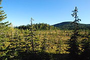
The lake Eben is referred to as a genuine raised bog, which has formed from a swamp and not only over a low bog after silting up. The peat layer is up to four meters deep, the mineral subsoil is sandy-clay. The lake Eben is arched in the center by about four meters opposite the western edge of the moor. Lake Eben is only flat when viewed from a distance - there are many grassy hills ( Bulten ) and small bodies of water (Schlenken, Flarken ) nearby . These water areas can be up to a meter deep, together with the Bulten ( Bult-Schlenken-Complex ) they make it practically impossible to cross the area.
The lake Eben is located in the southwestern extension of the landscape protection area Pack - Reinischkogel - Rosenkogel .
The area east of the lake Eben consists of different rock layers and was investigated through detailed geological studies.
history
The area around Lake Eben is mentioned for the first time in a list of alpine pastures that arose in a dispute between the Schwanberg rulers and the Archbishop of Salzburg around 1320: “enhalb des see eneben den stainen, ...” ('beyond the lake next to the Steinen '- reference to the earlier name Schröfel-See ).
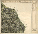
Georg Matthäus Vischer's map of Styria from 1678 shows the area as Schröfl See . The lake is shown as a source lake of a river, which forms a combination of Stoffbach , Rettenbach , Laßnitz and Wildbach in its course .
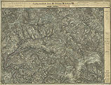
In 1728, the Schröfl See is shown on Matthäus Seutter's map as the dominant body of water on the border between Styria and Carinthia. in See in this position is also shown in the Josephinische Landesaufnahme 1787. However, it is no longer identified as the origin of a body of water.
The age of a piece of peat recovered in 1973 from about 3.0 to 3.1 meters deep in Lake Eben was determined by radiocarbon dating to be 5720 ± 140 years. The time in which the plants of this piece died is thus around 3750 BC. Chr.
Pictures of the lake Eben

In the south of Lake Eben is the Bärofen.

Small channels flow out of the Eben lake west to the Waldensteinerbach and east to the Stoffbach

Historic forest path to the lake Eben
Bürstling meadows in the light forest around Lake Eben are evidence of past grazing.

Earlier traffic relationships are documented in historical maps and are easily recognizable in the terrain

One of the wine routes between Hebalm and See Eben
The viewing platform offers a good overview, with the Stoff Kogel in the background in the former municipality of Osterwitz

The sea from the east

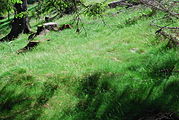
Mounds of grass (Bulten, partly overgrown with spruce) and bodies of water (Schlenken) form the Lake Eben
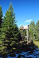
The viewing platform is rarely visited and not easy to find in the forest

The platform is unattended and can only be used at your own risk
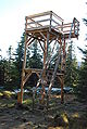
The viewing platform was built in spring 2008

Some Schröfeln east of the lake Eben (house rock of the old fabric hut)

Accessing and circumnavigating the lake Eben form a longer hike at around 1500 meters above sea level

Refreshment on the way to See Eben on the north-south long-distance hiking trail between the Rehbockhütte and the Stoffhütte


Historical maps
Historical maps are evidence of uses as alpine pastures and forest areas and for traffic connections in this area.

Lake Schröfl in the 17th century (map by Georg Matthäus Vischer )

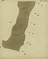
The Schröfl See in 1728 (map by Matthäus Seutter )

The lake Eben as "Schröfel See" in the south of the Hebalm (bottom left, approx. 1789, Josephinische Landesaufnahme )

The catchment area of the "Schrefel Bach" in Preitenegg

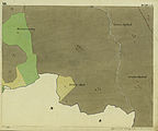
The area "near the Seekogel" on the Styrian border around 1835, Franziszeische Landesaufnahme
Called “am Seeboden” in Carinthia, with “Schrefl Bach” and Schreflhof in Preitenegg

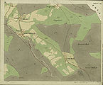
Special map of the francisco-josephine (3rd) land survey , depiction 1894, partially corrected until 28th XI. 1913

Special map, status of the forest cover around 1937
The lake Eben in the recording sheet of the 3rd regional survey 1877/78


- In the cadastre around 1825
The basic tax register from the early 19th century was based on the land registers in the Austro-Hungarian Empire . It also documents in detail the properties around the See Eben with the status of management at the time. (A)

Osterwitz: end of the Rettenbach valley with the former farms vlg. Nigeljosel and bubble fringes (fabric)

Osterwitz: catchment area of the Stoffbach near the former Stefelpeter farm
Oberpreitenegg: Course of the wine route west of Lake Eben
Oberpreitenegg: Schreflhof and its surroundings
Oberpreitenegg: Schreflbach, inner and grave yard hold, mast ox loft
Oberpreitenegg: Wine road towards Zennegg and junction to Osterwitz (above)


- (A)Gray = forest, green = meadow, scrub, W. = willow, H = hat willow, light yellow (in these leaves from 1825 it is difficult to distinguish the color from the paper) = alpine pasture or less productive, darker yellow = arable land, brown = path parcels. Yellow buildings = wooden buildings, red buildings = stone buildings. JM = young maize, MH = medium wood, SH = pole wood, HS = high-stemmed, felling forest. Supplements up to the second half of the 19th century are shown in red.
Individual evidence
- ↑ Arthur Winkler-Hermaden a. a .: Scientific study results of the working group for geological-pedological investigations in the catchment area of the Laßnitz river in south-western Styria. Austrian Academy of Sciences, Vienna, mathematical and natural science class Dept. I, 149, issue 7-10, pages 225-226. Peter Beck-Managetta: About the geological structure of the Koralpe. In: G. Weissensteiner: Mineralien der Koralpe. Association of Styrian Mineral Collectors, Graz 1979, page 6 (Die Eisenblüte, 1st special volume).
- ↑ a b Saualpe, Lavanttal, Koralpe, Schilcherheimat region. Hiking, cycling and leisure map; S-points, leisure guide, place register. Freytag-Berndt, Vienna 2006, ISBN 3-85084-322-X (Freytag - & - Berndt hiking maps, part 237).
- ↑ Jakob and Wilhelm Grimm : German Dictionary . Volume 2 Beer Murderer-Dwatsch. Leipzig 1860. Keyword Bodenfeld . Column 215, line 13. Reprint from Deutscher Taschenbuch Verlag. Munich 1991. dtv 5945. ISBN 3-423-05945-1 . Structure quoted from: The digital Grimm - Electronic edition of the first processing. Version 12/04. Verlag Zweausendeins, Frankfurt am Main. Competence center for electronic cataloging and publication processes in the humanities at the University of Trier in conjunction with the Berlin-Brandenburg Academy of Sciences. ISBN 3-86150-628-9 .
- ↑ Land register district court Wolfsberg, cadastral community 77008 Oberpreitenegg, deposit number 38. Queryed November 2, 2008.
- ^ Picture of the lake by: Curt Fossel, Hermann Kühnert: Natural history features in Styrian communities. Leopold Stocker Verlag , Graz 1994, ISBN 3-7020-0692-3 (Naturschutz-Handbuch, 4), page 24 of the unpaginated color plates in the middle of the book.
- ↑ Jakob and Wilhelm Grimm: German Dictionary . Volume 15 Schiefeln-Seele. Leipzig 1899. Keyword rugged for cliffs, jagged rocks, stone walls, rock heads. Column 1763, line 35.
- ^ Austrian map 1: 50,000: sheet 188 Wolfsberg. Recorded in 1959/60. Complete map revision in 1969. Individual supplements in 1971. Edited by the Federal Office for Metrology and Surveying (Landesaufnahme) in Vienna. The same applies to the 1976 revision of this map.
- ^ Austrian map 1: 50,000. Sheet 188 Wolfsberg. Recorded in 1959/60. Map continuation 1991. Individual supplements 1993. Edited by the Federal Office for Metrology and Surveying (Landesaufnahme) in Vienna.
- ↑ a b c Werner Tscherne : Commerce, trade and industry. In: Helmut-Theobald Müller (ed.), Gernot Peter Obersteiner (overall scientific management): History and topography of the Deutschlandsberg district. Steiermärkisches Landesarchiv und Bezirkshauptmannschaft Deutschlandsberg, Graz 2005, ISBN 3-901938-15-X (Great historical regional studies of Styria, Volume 3, first part), pp. 381–382.
- ↑ a b c district topography. First part of the volume. Gerhard Fischer: peasantry, agriculture and forestry. Pages 357-358.
- ^ Wilhelm Brandenstein: The place names of the Rauriser valley. In: The nature lover. Issue 3/4, 1932, page 67. Quoted from: Fritz Freiherr Lochner von Hüttenbach: Wilhelm Brandenstein. Small name-based work. Akademische Druck- und Verlagsanstalt, Graz 1978, ISBN 3-201-01038-3 , p. 87 - using the example of Wörth / Wert, where a spelling with "ö" is traced back to an attempt to write the name in High German.
- ^ Ordinance of the district captain of Deutschlandsberg on the declaration of the moor on the lake Eben in Osterwitz as a nature reserve. In: Grazer Zeitung. Year 2010, 48th issue, issued on December 3, 2010. Pages 640–641, in force from December 4, 2010. Index of Styrian national law 5500/02/242. The ordinance of the District Commission of Deutschlandsberg of January 4, 1979, GZ: 6 Oa 3/78, which had been in effect until then, on the declaration of the “Moor on the Lake Eben” as a nature reserve (plant protection area) was thus suspended.
- ↑ Martin Magnes: Hochmoor on the lake level. ( Memento of the original from September 30, 2007 in the Internet Archive ) Info: The archive link was automatically inserted and not yet checked. Please check the original and archive link according to the instructions and then remove this notice. Excursion of the Institute for Plant Sciences, Department of Systematic Botany and Geobotany of the Karl-Franzens-University Graz on the subject of "Vegetation and ecology of moors in the Eastern Alps" from July 1st to 2nd, 2002.
- ↑ Landscape protection area 02: Ordinance of the Styrian state government of May 25, 1981, stmk. State Law Gazette No. 37/1981 in the version of the correction (new map display) No. 64/1981. Map of the protected area ( Memento of the original dated December 21, 2007 in the Internet Archive ) Info: The archive link was inserted automatically and has not yet been checked. Please check the original and archive link according to the instructions and then remove this notice. in the Digital Atlas Styria.
- ↑ Peter Beck-Mannagetta : The geology of the catchment area of the Laßnitz (West Styria) . Dissertation at the Philosophical Faculty of the University of Vienna, published in: Mitteilungen des Alpenländischer Geologische Verein (Communications from the Geological Society in Vienna). Volume 34. Vienna 1941. Gerda Woletz: The bed load conditions of the Laßnitz , in: Artur Winkler-Hermaden, Peter Beck-Mannagetta, Karl Bistritschan, Gerda Woletz, Karl Schoklitsch, Herbert Pichler: Scientific study results of the working group for geological-soil science in the catchment area of the Laßnitz River in southwest Styria. Session reports of the Academy of Sciences in Vienna, mathematical and natural science class, Department 1, Volume 149, Issue 7 to 10 (presented at the session on June 27, 1940). Verlag Hölder-Pichler-Tempsky Vienna 1940. Pages 247-257.
- ^ Gerhard Fischer: Osterwitz. a miraculous place in the high pürg. Life, joy and suffering of an area and its inhabitants. Osterwitz Community, Osterwitz 2002, page 117.
- ↑ Vischer Karte 1678 ( Memento of the original dated May 30, 2007 in the Internet Archive ) Info: The archive link was inserted automatically and has not yet been checked. Please check the original and archive link according to the instructions and then remove this notice. , Geographical Information System GIS of the State of Styria as part of the Digital Atlas Styria. Select the map under historical maps "Vischer map 1678"
- ↑ Heinz Felber: Vienna Radium Institute Radiocarbon Dates VI. In: Radiocarbon. Vol. 17, No. 2, 1975, pages 247-254 (Sample No. VRI-387).
Coordinates: 46 ° 53 ′ 55 ″ N , 15 ° 1 ′ 25 ″ E