
Upper Styria
| map | |
|---|---|
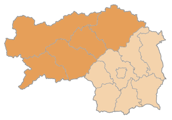  |
As Upper Styria (obsolete and Upper Styria ) refers to the northern, mountainous and forested part of the Austrian federal state of Styria . The remainder of today's federal state is what was once Central Styria and what is now East and West Styria , while Lower Styria is in what is now Slovenia .
geography
While there are large industrial settlements in the southeastern part between Judenburg and Mürzzuschlag ( Mur-Mürz-Furche ) , the western and northern parts ( Oberes Ennstal , Ausseerland , Paltental , Murau ) are more agricultural and touristy .
Upper Styria consists of the districts:
It is divided into three sub-regions:
- Eastern Upper Styria ( Hochsteiermark , districts: Leoben and Bruck-Mürzzuschlag): Upper Murtal from Kraubath , Mürz Valley , Liesingtal , Erzberg Region, Vordernbergertal , Mariazellerland with Upper Salzatal
- Western Upper Styria (districts: Murau and Murtal): Upper Murtal to Kraubath with side valleys (actually: southwest of Upper Styria)
- Liezen (district): Ennstal and side valleys, Ausseerland , lower Salzatal (north-west of Upper Styria)
See also
Web links
- EU regional management Upper Styria East
- EU regional management Upper Styria West
- EU regional management in Liezen
Individual evidence
- ↑ a b The lower Salzatal to Wildalpen belongs to the Liezen district, the orientation and allocation of the lower Gesäuse region ( Hieflau , Landl ) to the regions was unclear during the preparations for the 2015 municipal structural reform .
Quarter of the early modern period : Quarter within the Drau / Cillier quarter · | · Quarter down from the Mürzthale / Vorauer Viertel / Grätzer Viertel · | · Quarter this half of the Piberalm / between Mur and Drau · | · Quarter within the Piberalm / Brucker Viertel
Circles in the 18th century : Bruck Circle | Graz District | Cillier circle | Judenburger Kreis | Marburg district
Regions of the 19th century: Central Styria | Upper Styria | Lower Styria