Stoffbach
| Stoffbach | ||
|
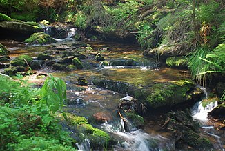
Stoffbach on the forest road between Stoffhütte and Brendlschlag |
||
| Data | ||
| location | In western Styria , Austria , from the middle Koralpe to the east to the Rettenbach | |
| River system | Danube | |
| Drain over | Rettenbach → Laßnitz → Sulm → Mur → Drau → Danube → Black Sea | |
| source | On the Stoffkogel in the middle part of the Koralpe 46 ° 53 ′ 6 ″ N , 15 ° 1 ′ 10 ″ E |
|
| Source height | 1540 m above sea level A. | |
| muzzle | In Osterwitz- Winkel in den Rettenbach coordinates: 46 ° 53 '45 " N , 15 ° 2' 35" E 46 ° 53 '45 " N , 15 ° 2' 35" E |
|
| Mouth height | 1050 m above sea level A. | |
| Height difference | 490 m | |
| Bottom slope | 18% | |
| length | 2.7 km | |
| Catchment area | 3.1 km² | |
| Drain |
MQ |
100 l / s |
| Right tributaries | unnamed tributary | |
| Communities | Deutschlandsberg | |
| Residents in the catchment area | approx. 3 | |
The Stoffbach is a tributary of the Rettenbach in the middle Koralpe in western Styria in Austria .
Geography and name
The Stoffbach rises on the Stoffkogel west of the summit in the saddle between Stoffkogel and Bärofen-Zug. This area was previously called "Hofhalt".
Its course lies entirely in the end of the Rettenbach (and later Laßnitz ) valley in the former municipality of Osterwitz. This valley head is formed by the ridge of the Koralpe, the Rettenbach flows into this valley from the north, the Stoffbach from the south.

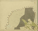
In spite of its belonging to the former municipality of Osterwitz, this area is sometimes partially counted as part of the village of Rettenbach of the former municipality of Kloster (today: both municipalities of Deutschlandsberg) (see map).
The name of the stream is derived from the farm vlg. Material. From this farm only the buildings of the (old and new) fabric hut remain at the level of the Hebalm next to the lake Eben . The cloth huts are former alpine huts of this farm, which are currently used as a residential building and only short-term restaurant and accommodation for an alpine club.
The Stoffbach takes in the small streams that flow east from the lake Eben .
The area of the Stoffbach can be reached via forest roads with a 3 km walk from the Hebalmstraße, Schutzhaus Freiländer Alm (Gasthaus Rehbockhütte). These streets are closed to motor vehicle traffic. Cross-country skiing equipment is advisable in snow conditions. From the transition to the forest road near the Stoffhütte, the stream runs in a pathless valley and can only be reached over unpaved and steep terrain.
The north-south long-distance hiking trail runs south of the Stoffhütte for about one kilometer parallel to the upper reaches of the stream.
history
The farms on the Stoffbach no longer exist. Their buildings and the associated mills have been demolished. The areas of these farms largely belong to the Deutschlandsberg forest estate of the Liechtenstein family. The arable and meadow areas are afforested. The former yard boundaries can be traced using the property boundaries in the digital cadastral map and in the home register.

The Stoff farm (also called Blasifranzl), after which the Stoffbach is named, was the largest farm in the creek's catchment area until the beginning of the 20th century. An inventory from 1780 names five pairs of oxen, a young bull (Stierl), two cows, five other cattle / calves, four pigs and 34 sheep as the farm's livestock. Fabric is a short form of the name Christopher, in turn, from the common medieval name Christopher derived. Other courtyards were vlg. Stefflpeter (already demolished in 1888) and vlg. Stefflpeterkeusche (also called "Pust" after the last tenant). The residential building of the Stefflpeterkeusche was demolished around 1980 after the homestead had been abandoned for decades and the farm building had not existed for a long time, and the green areas were reforested.

The Stefflpeter farm was partially on its back, which is formed by the Stoffbach and an unnamed tributary to the east. Whether this side stream was the body of water called "Kollpächl" (Kohlbach, from the work of a Koehler), which appears in a land register description of the Stefflpeter farm from 1680, or whether it is a name used earlier for the Stoffbach is not verifiable.
In the original file of the property tax cadastre , which reflects the status of the years around 1825, the Stoffbach is recorded as "Osterwitz Bachl".
The Stoffbach is the course of water that is shown on the map of Styria by Georg Matthäus Vischer from 1678 as the eastern outflow of the Schröfl Lake , today's Lake Eben . In its further course this river formed a combination of Rettenbach , Laßnitz and Wildbach .
The location of the stream is a guide
The Stoffbach is marked on the usual maps, but the name is not given. Its course is used for orientation for the population and can occur in verbal information to users of the north-south long-distance hiking trail , because it is clearly recognizable and (on the forest road bridge or a ford of an old hiking trail) may not be crossed if the long-distance hiking trail to the south is used should be: The forest road over the Stoffbach leads away from the long-distance hiking trail many kilometers east into the side valleys of the source area of the Laßnitz in Liechtenstein's forest district Deutschlandsberg, community Deutschlandsberg.

Route of the Deutschlandsberg forest railway
The catchment area of the Stoffbach forms the western border of a large logging area on the Stoffkogel that was cut down around 1955 . This logging reached on a steep mountain slope from the summit of the Stoffkogel to the former farm vlg. Stefflpeterkeusche in the valley of the Rettenbach (sometimes called Stefflpeterbrendl). His wood was transported away by the Liechtenstein Forest Railway until it ceased operations on July 27, 1959. The railway line belonged to the northern branch of this forest railway. It had its end of track in this felling. The wood was brought to the Kupper loading station via the rail track with a track width of 600 mm, from where it was transported by a 3.5 km long cable car down to the valley to the reloading point in Freiland and on to Deutschlandsberg.
Remnants of the forest railway line are visible as a step in the terrain below the forest road in the growing forest in the area of this logging (2006 thinning), e.g. B. at 46 ° 53 '20.2 " N , 15 ° 2' 1.7" O
Flora and fauna
The Stoffbach is completely in the forest area (mainly spruce , more rarely maples , ash and birch ).
Dragonflies and caddis flies live near the water . Their larvae are a reliable indicator of water quality; they only occur in bodies of water with good to very good water quality.
geology
The course of the Stoffbach lies in gneiss mica schist and gneiss quartzite of the Koralm crystalline (no slab gneiss). Small flakes of mica are common in sandy areas and can make the sand shine in sunlight.
Just below the transition from the forest road south of the fabric hut, a mining site is marked on mica (according to the map, a tunnel , die; not recognizable in nature).
Water quality
The water quality is quality class I (unpolluted, practically drinking water quality). The water hardness is low (range 1–2 - soft water).
credentials
- ↑ Digital cadastral map of the cadastral community of Osterwitz. Cadastral parish No. 60001.
- ^ Gerhard Fischer: Osterwitz. a miraculous place in the high pürg. Life, joy and suffering of an area and its inhabitants. Osterwitz 2002. Editor and publisher: Osterwitz community. Production: Simadruck Aigner & Weisi, Deutschlandsberg. No ISBN. Farm overview on page 295.
- ^ Fischer: Osterwitz. Page 339.
- ^ Fischer: Osterwitz . Page 308.
- ↑ Pictures of the farms, protocols, etc. in: Fischer: Osterwitz. Pages 307/308 (Stefflpeterkeusche), 320/321 (Stefflpeter) and 338-340 (fabric).
- ^ Fischer: Osterwitz . Page 321.
- ↑ Vischer Karte 1678 ( Memento of the original dated May 30, 2007 in the Internet Archive ) Info: The archive link was inserted automatically and has not yet been checked. Please check the original and archive link according to the instructions and then remove this notice. , Geographical Information System GIS of the State of Styria as part of the Digital Atlas Styria. Select the map under Historical Maps "Vischer Map 1678".
- ^ Fischer: Osterwitz . Page 132.
- ^ Fischer: Osterwitz . Page 134.
- ↑ The illustration of the route by Manfred Hohn : Waldbahnen in Österreich , Verlag Slezak, Vienna 1989, ISBN 3-85416-148-4 , is a bit too short in this detail because it only contains the then status of the route in the provisional edition of the Austrian Official map 1: 50,000 reproduces: Sheet 188 Wolfsberg. Published by the Federal Office for Metrology and Surveying, Vienna (regional survey), map correction 1940, individual supplements 1954.
- ^ Geological map of the Republic of Austria 1: 50,000, sheet 188 Wolfsberg. Edited by Peter Beck-Mannagetta . Published by the Federal Geological Institute, Vienna 1980.


