
Osterwitz
Coordinates: 46 ° 51 '36 " N , 15 ° 5' 26" E

Osterwitz is a part of the municipality of Deutschlandsberg in the district of Deutschlandsberg in western Styria . Until the end of 2014 it was an independent municipality with 148 inhabitants (as of October 31, 2013) and currently has 137 inhabitants (as of April 25, 2019).
As part of the structural reform of Styria , Osterwitz was merged with the municipalities of Deutschlandsberg, Bad Gams , Freiland bei Deutschlandsberg , Kloster and Trahütten to form the municipality of Deutschlandsberg in 2015 . The basis for this is the Styrian Municipal Structural Reform Act - StGsrG. A complaint that had been brought to the Constitutional Court in this connection and was based on the fact that the municipality had sought a merger with the municipality of Trahütten was unsuccessful. Another complaint in which the three communities of Trahütten, Osterwitz and Freiland spoke out against the merger with Deutschlandsberg also remained unsuccessful.

geography
Osterwitz lies on the border with Carinthia and consists of a single cadastral community of the same name . This KG has the number 61046. Another cadastral community with the same name and number 74520 is located near St. Georgen am Längsee in Carinthia.
The southern part of Osterwitz lies in the catchment area of the Bet (h) leitenbach. This brook was also called Osterwitzbach , Hand Alpen Bach or (1835, see map) Lassnitz . It flows into the (Niedere) Laßnitz near Freiland .
The waters of the north-western part flow into the Laßnitz (with Brendlbach and Hofbauerbach), or (from the municipality of Osterwitz-Winkel) also into the Rettenbach and its tributary, the Stoffbach .
The highest point in Osterwitz is the Handalm (1,853 m).
geology
Osterwitz lies entirely in the Koralpe crystal . The ridge on which the town center lies consists of gneiss mica schist , which - except in the west - is surrounded by slab of gneiss . There are some pegmatites with quartz veins in it . To the west of the town center are two strips of the very hard rock eclogitamphibolite , and the two elevations called large and small Pöschlkogel between Laßnitz and Rettenbach also consist of this rock. The end of the Rettenbach valley and the summit area of the Stoffkogel on the western border are made of gneiss quartzite . In this area there is a mining site on mica to the south of the cloth hut (according to the map, a tunnel , die ; not recognizable in nature). To the south of the Stoffkogel is an area made of Hirschegger gneiss; this rock also forms a strip of terrain on the northern slope towards Laßnitztal.
Extraordinary petrographic conditions are described in the base of an approximately 80 m high rock furnace in the west of Osterwitz (east of the Weberbauer farm): A total of around two to four meters of this rock consists of layers of amphibolite, pomegranate , quartz- zoisite and muscovite slate that are centimeter to decimeter thick , also boudinages of quartz pomegranate rock occur. Only above these layers does the furnace consist of eclogite amphibolite, which is generally present in the area .
The Koralm, in whose area Osterwitz lies, is rich in minerals. A number of mineral sites have been documented for the Osterwitz area. There is evidence of apatite , epidote , mica , hornblende , muscovite, quartz, rutile , tourmaline , glass opal , uranium opal , feldspar and schörl .


Neighborhoods
| Preitenegg | monastery | |
|
Wolfsberg / Frantschach-Sankt Gertraud |
.svg)
|
Outdoors |
| Gressenberg | Trahütten |
history
Osterwitz was first populated by the Celts and later by the Slavs . The name Osterwitz comes from the Slavic language , it is derived from the word oster (sharp, pointed) and means Spitzberg (from * ostrovica ), Scharfenberg, sharp corner or edge , with a variant of the name in old maps actually being "Ostrowitz". In another source, the name is translated as a settlement on a towering mountain . In the south of Osterwitz there is a mountain with a remarkably steep summit shape that is otherwise not found in the area (Kumpfkogel). The name is also derived from an old mule track that made a sharp change in direction. The Spitzegg area is located in the south-east of the village of Osterwitz : it is a Slavic-German double name that indicates sections of the population of Slavic and German origins.
The name is first mentioned in a document from 1322, when the area was owned by the diocese of Salzburg . The church was first mentioned in a document in 1370. The pastor of Osterwitz already had such a reputation in the 14th century that a minister could afford to steadfastly refuse to appear at a synod on June 11, 1381 and that this is seen as newsworthy in the literature.
A reference to a small castle in the Osterwitz area has been published for the 15th century: in 1429 fiefs over Huben and Zehent were awarded “to the Purgstall near Osterwitz”. This formulation is interpreted as an indication that the defense structure was already in ruins at that time and only its location (the castle site) was known. One point where this facility could have been is south of the village of Osterwitz on a small hill.
From 1445 Osterwitz became the seat of an independent parish, in 1480 the Turks destroyed the church building. In the 15th and 16th centuries, after the quarter division of Styria in 1462 , Osterwitz was in the "Quarter between Mur and Traa" (Drau), the predecessor of the Marburg district .
The border from Osterwitz on the Koralpenzug against Carinthia (Handalm, Wildbacher Alm etc.) was also a border that was relevant for official measures to combat epidemics, for example against the plague in the years from 1712 . At the Weißofen and Schönofen on the Handalmzug there were guard huts at the mountain crossings, which were manned by several men. They were on the borders generally guarded road and locking up (Verhackungen, barricades erected) that prevented the movement of people and goods to neighboring countries and should thus impede the spread of the disease.
In the 16th and 17th centuries, Osterwitz belonged to the "Deutschlandsberg Regional Court". However, this only applied outside the eaves : within it, full lower jurisdiction lay with the respective landlord in the 16th century.
The first documentary mention of a parish school can be found in 1611. From 1770, when people and houses were first recorded in Austria , houses and people from Osterwitz were recorded independently. This registration took place within the framework of the army reforms under Maria Theresa and Joseph II and led to the introduction of the " numbering sections " (conscription communities). Osterwitz was such a section. Together with the other numbering sections in Trahütten and Warnblick, Osterwitz belonged to the Landsberg advertising district .
In the years that followed, the numbering section became the tax municipality and cadastral municipality of the same name Osterwitz. Until 1780, the parish also included Trahütten , Warnblick and Laufenegg near Deutschlandsberg in addition to Osterwitz .
The use of the Bethleitenbaches between Osterwitz and Tranhütten for Holztrift is still occupied 1890th
On June 30, 1995, a sensational murder occurred in the drug milieu in Betleitengraben , in which the 30-year-old Graz pimp and drug dealer Werner Happer was shot with a submachine gun. The crime took place on a forest path near the Zach saw, it was not cleared up. A murder trial ended in acquittal.
In spring 2012, the Osterwitz community decided to strive for a merger with the Trahütten community and to reject the more far-reaching merger plans with Deutschlandsberg as part of the Styrian community structural reform. A corresponding application for this merger was rejected by the Styrian state government , but a complaint to the Constitutional Court was unsuccessful.

Leo Simon Reinisch
An important son of Osterwitz was the Egyptologist, Mexicanist and Africanist Leo Simon Reinisch (1832-1919) , who is still internationally known today .
Karl Lukesch
The missionary and collector of cultural objects, Karl Lukesch, was provisional agent of the Osterwitz parish from 1958 to 1960 .
population
Population development
In 1770, 460 inhabitants ("souls") are named for Osterwitz. According to this, the number of inhabitants is 454 (1782), 82 families (1810), 321 (1812), 385 (1846), whereby the censuses did not use uniform recording bases and z. B. During the Napoleonic wars, significant parts of the male population could not be recorded at their place of residence. After that, the population of the Osterwitz community continued to decline almost continuously. Only in the 1920s was the population able to recover more clearly. In 2014, compared to 1869, only about a third of the previous population lived in the municipality. Areas in which there were still several farms until the 20th century, such as at the end of the Rettenbach valley, were already without permanent settlement.

Population structure
According to the 2001 census, the municipality had 167 inhabitants. 97.6% of the population have Austrian citizenship. 95.8% of the population professed to be part of the Roman Catholic Church , 3.0% were without religious beliefs. As of October 31, 2008, the municipality had 155 inhabitants (counted according to the main residences of the Central Residential Register).
Culture and sights
Parish church Maria Osterwitz : On the ridge that stretches from the Handalm to the east in the direction of the Graz basin , the pilgrimage church with the patronage of Our Lady of Sorrows is located in the center of the community . This church is mentioned in a document in 1382, it is a late Gothic building with baroque side aisles. The Gothic west tower with its onion helmet can be seen from afar in the area. On August 15th of each year (Feast of the Assumption of Mary , “great women's day”) the church is the destination of several pilgrimages from the western Styrian region. On June 21, 2015 the anniversary festival “1000 years of Maria in der Osterwitz” was celebrated. This festive date was linked to the fact that in 1715 the Archbishop of Salzburg, who was then responsible for this area , had approved the holding of a 700th anniversary celebration.
The tower is the oldest surviving part of the church. In 1765 the tower received the onion-shaped roof made of wooden shingles, after the church had already been re-covered with 40,000 wooden shingles in 1715. A new tower cross was added in 1801 and a new cross and the metal covering of the tower roof were added in 1871 after lightning damage. In 2015 the tower was given a roof made of sheet copper.
The high altar dates from 1780–1800, the statue of grace ( Pietà ) in the church from around 1500.
Natural monuments
A Scots pine southwest of the village of Osterwitz is under nature protection. An area of 1030 m² around the tree is protected. The basis for protection as a natural monument in 2010 is a decision from the Deutschlandsberg district administration.
A second natural monument is a winter linden tree (Tilia cordata) in the center of Osterwitz on an area of 230 m² in its vicinity.
Economy and Infrastructure
In the 2001 census of workplaces , there were 8 workplaces with a total of 15 employees in what was then the municipality, 7 of which were employed as well as 49 out-commuters and 2 in-commuters. The settlement area of the municipality (permanent settlement area) comprises only 7.4% of the municipality area, the rest are forest and alpine pastures.

The traffic is opened up via side roads of the Koralm area: connections exist via the Laßnitz valley to monastery and Freiland and via the valley of the Betleitenbach to Trahütten . Osterwitz never had a connection to public transport. In the summer 1934 bus timetable, the route map shows a branching off of the bus route No. 2079 (Deutschlandsberg↔Trahütten↔Glashütten) from Trahütten to Osterwitz, but the timetable printed in the same volume does not mention any connections to Osterwitz. The next bus stations were in Kloster until this bus line was discontinued in 2013 (most recently only school traffic). The bus line via Trahütten to Glashütten has not existed since 1991, after its operation had to be further restricted in the years before due to a lack of demand.

The road connection to the west via the Posch-Alm via the Wildbachersattel to the Weinebene was passable with off-road vehicles until the 1940s. It then fell into disrepair and only remnants can be recognized. There are also only remnants of the extensive feeder routes of the Deutschlandsberg forest railway . A road ran west across the lake Eben to Carinthia, which was followed in parallel by the forest railway line and which was expanded into a forest road in the 1970s. This connection is closed to general traffic, but can be used as a hiking trail.
The community center was located in the building of the former elementary school until 2014. The elementary school of Osterwitz (school code 603191), which had existed for 399 years, was closed after the end of the 2009/10 school year due to insufficient student numbers. There were only five primary school-age children living in the community.
Wind turbine
The Handalm in the southwest of Osterwitz is one of those areas in which wind turbines can be built according to the rules of spatial planning . It is designated as a "priority zone" in which the wind supply enables high performance.
In autumn 2017, 13 wind turbines were put into operation on the ridge of the Handalm.
politics
Municipal council
In the last election on March 21, 2010 the number of seats (6: 3) did not change, the votes shifted by 2.69% to the ÖVP. The result was 64.55% ÖVP, 35.45% SPÖ. In the previous municipal council elections in 2005, the ÖVP was able to maintain its supremacy in Osterwitz and achieved 61.86% with a gain of 0.32%. The SPÖ was able to gain 15.06% and reached 38.14%, which meant winning a mandate.
Small region
The community was a member of the small region "Core area Bad Gams - Deutschlandsberg - Frauental" (with monastery and open land). In this community association the tasks of road maintenance, shopping and child and youth care should be done together. The association was constituted on December 9, 2010. It has legal personality and is based on a voluntary agreement. Its seat is Frauental, its legal basis is § 38a of the municipal code.
coat of arms
The Osterwitz community did not have an official coat of arms until it was dissolved.
Historical maps and sheets of the cadastre
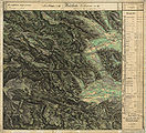
- historical maps of the Osterwitz area from the three regional surveys in the period from approx. 1789 to 1910

The area of "Ostrowitz" (left) in the Josephinische Landesaufnahme , around 1790

The northeast of Osterwitz (bottom left) with the Schrefel Lake on the border with the Hebalm

western border on the Weinebene
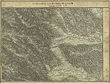
Osterwitz in the Franziszeische Landesaufnahme , approx. 1835

Northwest of Osterwitz near the Hebalm

The southwest around 1835

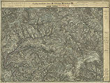
In the francisco-josephine (3rd) land survey , around 1895. Partly corrected until November 28, 1913.

Osterwitz around 1937 with a forest railway line and cable car
Osterwitz in the north-west of Deutschlandsberg , record sheet of the 3rd land record 1877/78
Northwest of Osterwitz with the Hebalm area
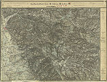
Southwest with Handalm and Laßnitztal

Rettenbach and Ober Mitterspiel in the northeast of Osterwitz (left)


- Cadastral sheets of the Osterwitz community around 1825

Title page of the cadastral copy of the styrian. State archives with page overview.

Osterwitz Winkel: Lake Eben, Nigeljosl, Blasefranzen (fabric), sheet I of the original folder of the cadastre

The "Osterwitz Bachl" ( Stoffbach ) at the former Steflpeter farm (demolished in 1888), sheet II

Steffelpeterkeusche / Pust, Böschl in Osterwitz-Winkl, sheet III


literature
- Regine Palli: Settlement, economic and socio-geographic structural changes in the communities of Freiland near Deutschlandsberg, Gressenberg and Osterwitz. Diploma thesis, Graz 1989.
- Gerhard Fischer: Osterwitz. a miraculous place in the high pürg. Life, joy and suffering of an area and its inhabitants. Osterwitz 2002. Editor and publisher: Osterwitz community. Production: Simadruck Aigner & Weisi, Deutschlandsberg. No ISBN.
Web links
- Homepage of the Osterwitz district
- History of the place and the church
- History of the area
- Pilgrimage and parish church Maria Osterwitz
- "Osterwitzer Roas" - musical journey through Osterwitz with pictures from old and new times
- Breeding of Tibetan yaks on an alpine farm in Osterwitz
- Statistical data on the former municipality (click on the individual lines on the linked page)
Individual evidence
- ↑ State of Styria: Final population status on October 31, 2013 ( Memento of the original from April 15, 2015 in the Internet Archive ) Info: The archive link was inserted automatically and has not yet been checked. Please check the original and archive link according to the instructions and then remove this notice. (Excel file, 85 kB); accessed on May 2, 2015
- ^ Styrian municipal structural reform .
- ↑ Section 3, Paragraph 2, Item 1 of the Act of December 17, 2013 on the reorganization of the municipalities of the State of Styria ( Styrian Municipal Structural Reform Act - StGsrG). Provincial Law Gazette for Styria of April 2, 2014. No. 31, year 2014. ZDB -ID 705127-x . P. 2.
- ^ Order of the Constitutional Court of October 2, 2013, B 932/2013.
- ↑ of the Constitutional Court of 9 December 2014 G 149/2014, 155/2014 G, G 158/2014.
- ^ Geological map of the Republic of Austria 1: 50,000, sheet 189 Deutschlandsberg. Edited by Peter Beck-Mannagetta . Published by the Federal Geological Institute . Vienna 1991.
- ^ Geological map 1: 50,000, sheet 188 Wolfsberg. Edited by Peter Beck-Mannagetta. Published by the Federal Geological Institute, Vienna 1980.
- ↑ Peter Beck-Mannagetta: Report 1967 on recordings on sheets Deutschlandsberg (189) and Wolfsberg (188). In: Annual report of the Federal Geological Institute for 1967. Negotiations of the Federal Geological Institute. Issue 3 (final issue). Vienna 1968. Page A 19.
- ↑ Richard Göd: Report on geological recordings on the sheet Wolfsberg (188). In: Negotiations of the Federal Geological Institute. Vienna 1972, volume 3. pp. A 38 – A 39.
- ↑ Josef Taucher, Christine Elisabeth Hollerer: The minerals of the federal state of Styria in Austria. Two volumes with CD-ROM. Graz 2001. Hollerer publishing house. ISBN 3-9501422-0-7 . Volume 2, page 438 (with references to the individual publications).
- ↑ Manfred Trummer: Slavic Styria. Slightly extended version of the lecture of the same name at the symposium “Being foreign - staying together. The Slovene Ethnic Group in Austria ”as part of the“ Slovene Days ”at the Karl-Franzens University in Graz, March 25-28, 1996. In: Christian Stenner (ed.): Slovenian Styria. Displaced minority in Austria's southeast. Vienna-Cologne-Weimar Böhlau Verlag 1997. ISBN 3-205-98690-3 . Pages 15-34. ( Page no longer available , search in web archives ) Info: The link was automatically marked as defective. Please check the link according to the instructions and then remove this notice. ( MS Word ; 87 kB)
- ^ Fischer: Osterwitz . Page 17.
- ^ Martin Albrecher: The place names in the judicial district of Deutschlandsberg. Diploma thesis at the University of Vienna 1999. Thesis. No publisher, no ISBN. Page 23.
- ↑ Fritz Lochner v. Hüttenbach: Styrian place names. On the origin and interpretation of names of settlements, mountains, waters and fields. In the series: Graz comparative works. Volume 21. Verlag Leykam Graz 2008. ISBN 978-3-7011-0116-0 . ZDB -ID 2083885-2 . Pp. 40-41.
- ^ Albert Muchar: History of the Duchy of Styria. 7. History of Styria under the rule of H. Leopold the Pious (Probus) separated from the Land of Austria in 1373 until reunification with Austria in 1457 under K. Friedrich IV. Grätz: Leuschner & Lubensky; 1864. p. 22.
- ^ Robert Baravalle: Castles and palaces of Styria. An encyclopaedic collection of the Styrian fortifications and properties, which were endowed with various privileges. Graz 1961, Stiasny publishing house. P. 78. The unspecified reference to a castle in the supplement to the map from Herwig Ebner, Castles and Palaces in Graz, Leibnitz, West Styria. Birken-Verlag, Vienna 1967 (2nd edition 1982, ISBN 3-85030-028-5 ), describes the location only approximately.
- ↑ Herbert Kriegl: On the outbreak of the plague of 1712 and 1713, part 3. In: Weekly newspaper Weststeirische Rundschau , June 12, 2020. 93rd year No. 24, p. 6.
- ↑ Raimund Dürnwirth : The border barrier Carinthia to Styria in the plague years 1713-1716. In: Carinthia I . Communications from the history association for Carinthia. Edited by August v. Jaksch . 92nd year No. 3–4. ZDB -ID 1438-2 , ISSN 0008-6606 Klagenfurt 1902. pp. 87, 89.
- ^ Anton Mell: High and lower criminal jurisdictions. Regional courts and truces in Styria. In: Anton Mell, Hans Pirchegger: Styrian court descriptions . As sources for the Historical Atlas of the Austrian Alpine Countries. I. Department. District court map: Styria. In the series: Sources on the constitutional and administrative history of Styria. I. Volume. Published by the Historical State Commission for Styria. Graz 1914. General: Pages XX – XLIV. For District Court Germany Berg: pages 245 -246 and 473 respectively (Burgfried Germany Berg) 246 -248 and 495th
- ^ Mell: Criminal Courts , Page XXVI.
- ^ A b Manfred Straka: Administrative boundaries and population development in Styria 1770-1850. Explanations for the first delivery of the Historical Atlas of Styria. Research on the historical regional studies of Styria, XXXI. Tape. Published by the Historical Commission for Styria - HLK. Self-published by HLK. Graz 1978. Page 213.
- ^ Manfred Straka: Numbering sections and advertising districts of Styria 1779/81. Maps on a scale of 1: 300,000. In: Historical Atlas of Styria . Published by the Historical Commission for Styria - HLK. Academic printing and publishing company. Graz 1977 1st delivery: Administrative boundaries and population development in Styria 1770–1850. Sheet 2 (sheet north).
- ^ Manfred Straka: Tax communities and advertising districts of Styria 1798–1810. Maps on a scale of 1: 300,000. In: Historical Atlas of Styria . Published by the Historical Commission for Styria - HLK. Academic printing and publishing company. Graz 1977. 1st delivery: Administrative boundaries and population development in Styria 1770–1850. Sheet 4 (sheet north)
- ^ Manfred Straka: cadastral communities and advertising districts of Styria 1818–1848. Maps on a scale of 1: 300,000. In: Historical Atlas of Styria . Published by the Historical Commission for Styria - HLK. Academic printing and publishing company. Graz 1977. 1st delivery: Administrative boundaries and population development in Styria 1770–1850. Sheet 6 (sheet north).
- ^ Franz Hafner: Die Holztrift with special consideration of its practice in Styria (with reference to the statistical yearbook of the Ministry of Agriculture). In: Gerhard Pferschy (ed.): Settlement, power and economy. Festschrift Fritz Posch for his 70th birthday. Publications of the Styrian regional archive. Volume 12. Graz 1981. Page 595.
- ↑ Robert Preis : The unsolved murder case - underworld showdown in the Betleitengraben. In: 111 gruesome places in Styria that you have to see. Verlag emons :, Graz 2018. ISBN 978-3-7408-0445-9 . P. 180. (Regarding the spelling “Zmuagweg”, “Entenbach” in the location of this book: the farm is called “vlg. Zmugg”, the area “Entersbach”).
- ↑ Hans Breitegger: A contract murder. In: Cold Case - Murderers Among Us: Unsolved Murder Cases in Styria. Edition Kleine Zeitung, Graz 2012. ISBN 978-3-902819-13-0 . P. 137.
- ↑ Trahütten and Osterwitz plan the uprising . In: Weekly newspaper Weststeirische Rundschau . No. 4 from January 25, 2013. Volume 86, ZDB -ID 2303595-X . Page 3.
- ↑ Decision of the Constitutional Court of December 2, 2013, B 932/2013.
- ↑ Simon Leo Reinisch on the 100th anniversary of his death , supplement to the city magazine Deutschlandsberg 5/2019.
- ↑ Out and about in Deutschlandsberg: Original objects from the Lukesch Collection go to Rio. In: Weststeirische Rundschau . No. 12, Volume 2020 (March 20, 2020) 93rd Volume. ZDB -ID 2303595-X . Simadruck Aigner u. Weisi, Deutschlandsberg 2020, p. 3.
- ↑ Municipal statistics see web link to Statistics Austria.
- ↑ a b weekly newspaper Weststeirische Rundschau . No. 26 of June 26, 2015. Volume 88 2015. Page 1.
- ↑ a b Maria in der Osterwitz. Manfred Kronawetter: 1000 years of Marientradition: 1015–1715–2015 In: Die Briefmarken, Philatelic trade journal. 63rd year. Vienna, June 2015. ZDB -ID 2189145-X . Page 45.
- ^ Kurt Woisetschläger, Peter Krenn: Dehio Handbook - Die Kunstdenkmäler Österreichs: Styria (excluding Graz). Topographical inventory of monuments, ed. from the Federal Monuments Office, Department for Monument Research. Publisher Anton Schroll. Vienna 1982. ISBN 3-7031-0532-1 . Page 349-350.
- ^ Decision of the district administration of Deutschlandsberg from April 18, 1978, reference number 6 R 4/77. Object no. 475. Digital Atlas Styria ( page no longer available , search in web archives ) Info: The link was automatically marked as defective. Please check the link according to the instructions and then remove this notice. Map service: flora & fauna, natural protected areas, natural monuments - if you hold down the left mouse button, enlarge the area by dragging. The information can be called up with "Identify object" (button "i"), and in the window that opens, look for "Natural monuments". Retrieved March 5, 2010.
- ^ Decision of the district administration of Deutschlandsberg of April 18, 1978, reference number 6 Oa 2/77. Object no. 474. Digital Atlas Styria ( page no longer available , search in web archives ) Info: The link was automatically marked as defective. Please check the link according to the instructions and then remove this notice. , accessed March 5, 2010.
- ↑ Statistics Austria: Commuter statistics ( page no longer available , search in web archives ) Info: The link was automatically marked as defective. Please check the link according to the instructions and then remove this notice. Page 373.
- ↑ Statistics Austria: permanent settlement area ( page no longer available , search in web archives ) Info: The link was automatically marked as defective. Please check the link according to the instructions and then remove this notice. of the municipalities. Page 28.
- ↑ Overview map of the motor vehicle lines in Styria, sheet 3 (south of Graz). In: Official Austrian course book. 83rd year. Rail, car and shipping connections in Austria. Railway connections in Central Europe. Air traffic. Published by the Federal Ministry of Trade and Transport, General Directorate for Post and Telegraph Administration. Summer service 1934, valid from May 15 through October 6, 1934. Large edition. Vienna 1934, p. 305.
- ↑ Year of the release from the duty to operate according to the Motor Vehicle Act. Anton Reinbacher: 70 years of GKB bus operation. In: The turntable. The employee magazine of Graz-Köflacher Bahn- und Busbetrieb GmbH. Issue 20, April 2005, ZDB -ID 2181683-9 . Page 7. Abridged and supplemented version of an article by this author in Omnibusspiegel 1992.
- ^ Fischer: Osterwitz . Page 139.
- ↑ Homepage of the Osterwitz community / news. Retrieved March 15, 2010.
- ↑ West Styrian Rundschau . No. 8, year 2013 (February 22, 2013), 86th year, ZDB -ID 2303595-X . Simadruck Aigner u. Weisi, Deutschlandsberg 2013, p. 3.
- ^ Weekly newspaper Weststeirische Rundschau . No. 50 of December 17, 2010. Volume 83 2010, ZDB -ID 2303595-X . Page 1.
- ↑ Styrian municipal code in the version of the amendment in the State Law Gazette No. 92, issued on September 4, 2008, issue 27, page 304 in conjunction with Section 2, Paragraph 1 of the Styrian. Municipal Association Organization Act (GVOG) 1997.

Bad Schwanberg | Deutschlandsberg | Eibiswald | Frauental an der Laßnitz | Great Saint Florian | Lannach | Pölfing-Brunn | Preding | Sankt Josef (West Styria) | Sankt Martin im Sulmtal | Sankt Peter im Sulmtal | Sankt Stefan ob Stainz | Stainz | Wettmannstätten | Wies
93 Former communities (dissolved since 1945):
Aibl |
Aigen |
Bad Gams |
Blumegg |
Breitenbach in West Styria |
Dietmannsdorf im Sulmtal |
Ettendorf near Stainz |
Feisternitz |
Field tree |
Freidorf an der Laßnitz |
Open field near Deutschlandsberg |
Gamsgebirge |
Garanas |
Gasselsdorf |
Georgsberg |
Gersdorf |
Grafendorf near Stainz |
Graggerer |
Grass shoe |
Greisdorf |
Greith |
Gressenberg |
Großradl |
Grub near Groß Sankt Florian |
Grünau an der Laßnitz |
Gundersdorf |
Gussendorf |
Hasreith |
Herbersdorf |
Hollenegg |
Kleinradl |
Monastery |
Kornriegl |
Kothvogel |
Kraubath (West Styria) |
Krottendorf an der Laßnitz |
Kruckenberg |
Laaken |
Lasselsdorf |
Lebing |
Limberg near Wies |
Mainsdorf |
Marhof |
Mettersdorf |
Michlgleinz |
Nassau |
Neudorf near Stainz |
Neurath |
Niedergams |
Oberhart |
Upper Latin |
Oisnitz |
Osterwitz |
Otternitz |
Petzelsdorf in West Styria |
Pichling at Stainz |
Pirkhof |
Pitschgau |
Rassach |
Rossegg |
Rostock |
Red wine |
Sankt Oswald ob Eibiswald |
Sankt Ulrich in Greith |
Schönaich |
Sierling |
Soboth |
Stainztal |
Stable yard |
Stammeregg |
Sterglegg |
Sulmeck-Greith |
Sulz |
Sulz-Laufenegg |
Tanzelsdorf |
Teipl |
Tobis |
Tobisegg |
Trahütten |
Trough |
Unterbergla |
Vochera am Weinberg |
Vochera an der Laßnitz |
Front village |
Forest in West Styria |
Wernersdorf |
Wetzelsdorf in West Styria |
Wielfresen |
Wieselsdorf |
Torrent |
Wohlsdorf |
Zeierling |
Zirknitz