
Gundersdorf (municipality of Sankt Stefan)
Coordinates: 46 ° 55 ' N , 15 ° 13' E

Gundersdorf is a place in western Styria . He was a municipality with 406 inhabitants (as of 2014) in the district of Deutschlandsberg ( judicial district of Deutschlandsberg ) in Styria . On January 1, 2015, Gundersdorf was merged with the communities of St. Stefan ob Stainz and Greisdorf as part of the Styrian community structural reform , the new community continues to bear the name of St. Stefan ob Stainz. The municipal council of Gundersdorf unanimously passed the resolution on August 1, 2013. Since September 16, 2013, the municipal office of Gundersdorf had already been in St. Stefan ob Stainz.
geography
location
Gundersdorf is located in western Styria on the Schilcherweinstrasse . It consists of the cadastral community of Gundersdorf with the villages of Assing, Windhagen and Hochstraßen in the north and the much smaller cadastral community of Grubberg in the south. The most important brooks in the area are the Sanibach, Lemsitz and Zirknitz. The community has a connection to the high-ranking road network with the A 2 southern motorway .
structure
Gundersdorf consists of the cadastral communities Grubberg and Gundersdorf (population in brackets as of January 1, 2020):
- Grubberg (90)
- Gundersdorf (296)
Neighboring places
| Ligist | Mooskirchen | |
| Greisdorf |
.svg)
|
|
| Sankt Stefan ob Stainz |
history
Early history
As early as the Neolithic Age , people lived in what is now Gundersdorf, at least for a time. Excavations during the construction of a quarry uncovered a fireplace and stone axes near the village of Hochstrasse . However, the artifacts were lost. Further reports of findings of skeletons and ceramics serve as a possible indication of an early medieval grave complex. Secure records of the municipality are only available from the 13th century.
First documentary mentions
In the princely land register of the Bohemian King Ottokar II. Přemysl from the years 1265 to 1267, Gundersdorf is first mentioned as "Gvndramsdorf". The name is probably derived from a personal name of a farm owner. The villages of Asing and Windhaagen also existed at this time and are mentioned in the same land register as "Afanch" and "Winthage". Hochstraßen, on the other hand, was first mentioned in documents as "Hochstrazz" in 1367. The name Grubberg is found for the first time in 1373 in the fief book of the Seckau monastery as "am Grueberperg".

Another story
Gundersdorf, Windhaagen and Asing originally belonged to the Lemsitz parish. Later the parish was renamed St. Stefan (ob Stainz) after the patron saint . Gundersdof still belongs to the parish of St. Stefan and the schools for the children of Gundersdorf are also located here. In the 19th century there were 66 houses with 344 residents in the Gundersdorf area, while Grubberg had 27 houses with 102 residents.
In 1985, the then community was able to open a new community and fire station, and a fully biological sewage treatment plant was added . In order to counteract the rural exodus, several apartment buildings were also built.
population
Population structure
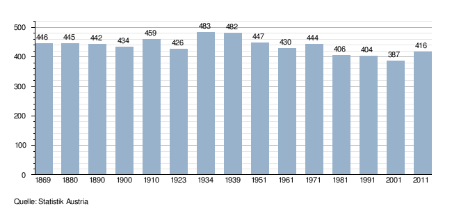
According to the 2001 census, Gundersdorf had 387 inhabitants. 97.4% of the population had Austrian citizenship. 91.2% of the population committed to the Roman Catholic Church , 5.7% were without religious beliefs.
Population development
For a long time the population of Gundersdorf fluctuated around 450 people. After the Second World War , however, the area's population began to decline continuously.
Economy and Infrastructure
According to the 2001 census of workplaces, there are 11 workplaces with 31 employees in Gundersdorf as well as 140 out-commuters and 26 in-commuters. The most important employer is the hotel and restaurant sector. There are 53 agricultural and forestry holdings (15 of which are the main occupation), which together cultivate 473 hectares (1999).
The access to traffic takes place via the south autobahn A2 and the Schilcher-Weinstrasse .
politics
Municipal council
The politics of the community was dominated by the ÖVP . In the municipal council elections in 2010, the ÖVP reached 69.49%, which was an increase of 1.11%. The SPÖ reached 16.61% in 2010 and gained 1.54% of the votes. The FPÖ reached 13.90%, that was a minus of 2.64%. The mandate status remained the same.
coat of arms
At the request of the former governor Waltraud Klasnic , the Styrian state government granted the former municipality of Gundersdorf the right to use its own coat of arms.
The blazon (description of the coat of arms) reads: "Divided diagonally to the left by red and gold, a golden chestnut leaf with panicles growing upwards from the gap, a red grapevine with two grapes and three leaves downwards."
Web links
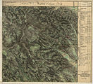
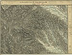
Historical maps
- historical maps of the area of Gundersdorf and its surroundings from the three regional surveys in the period from approx. 1789 to 1910
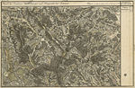
Kunersdorf north of Lemsitz (far right)

The east of Gundersdorf in the Zirknitz valley

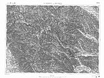
Lemsitztal north of Stainz, Josephinische Landesaufnahme , around 1780
Accommodation for 26 men and 4 horses according to the Franziszeischer Landesaufnahme , around 1835

Ligist and the middle course of the Kainach, recording sheet of the state recording , 1877/78
Stainz, Rosenkogel , Reinischkogel
In the francisco-josephine land survey , approx. 1910


Individual evidence
- ^ Announcement of the Styrian state government of September 26, 2013 on the union of the communities of Greisdorf, Gundersdorf and Sankt Stefan ob Stainz, all political district of Deutschlandsberg. Styrian Provincial Law Gazette of October 14, 2013. No. 98, 28th issue. Pp. 554-555.
- ^ Gundersdorf: First step towards the merger. In: Weststeirische Rundschau. No. 37, year 2013 (September 13, 2013), 86th year, ZDB -ID 2303595-X . Simadruck Aigner u. Weisi, Deutschlandsberg 2013, p. 1.
- ↑ Statistics Austria: Population on January 1st, 2020 by locality (area status on January 1st, 2020) , ( CSV )

Bad Schwanberg | Deutschlandsberg | Eibiswald | Frauental an der Laßnitz | Great Saint Florian | Lannach | Pölfing-Brunn | Preding | Sankt Josef (West Styria) | Sankt Martin im Sulmtal | Sankt Peter im Sulmtal | Sankt Stefan ob Stainz | Stainz | Wettmannstätten | Wies
93 Former communities (dissolved since 1945):
Aibl |
Aigen |
Bad Gams |
Blumegg |
Breitenbach in West Styria |
Dietmannsdorf im Sulmtal |
Ettendorf near Stainz |
Feisternitz |
Field tree |
Freidorf an der Laßnitz |
Open field near Deutschlandsberg |
Gamsgebirge |
Garanas |
Gasselsdorf |
Georgsberg |
Gersdorf |
Grafendorf near Stainz |
Graggerer |
Grass shoe |
Greisdorf |
Greith |
Gressenberg |
Großradl |
Grub near Groß Sankt Florian |
Grünau an der Laßnitz |
Gundersdorf |
Gussendorf |
Hasreith |
Herbersdorf |
Hollenegg |
Kleinradl |
Monastery |
Kornriegl |
Kothvogel |
Kraubath (West Styria) |
Krottendorf an der Laßnitz |
Kruckenberg |
Laaken |
Lasselsdorf |
Lebing |
Limberg near Wies |
Mainsdorf |
Marhof |
Mettersdorf |
Michlgleinz |
Nassau |
Neudorf near Stainz |
Neurath |
Niedergams |
Oberhart |
Upper Latin |
Oisnitz |
Osterwitz |
Otternitz |
Petzelsdorf in West Styria |
Pichling at Stainz |
Pirkhof |
Pitschgau |
Rassach |
Rossegg |
Rostock |
Red wine |
Sankt Oswald ob Eibiswald |
Sankt Ulrich in Greith |
Schönaich |
Sierling |
Soboth |
Stainztal |
Stable yard |
Stammeregg |
Sterglegg |
Sulmeck-Greith |
Sulz |
Sulz-Laufenegg |
Tanzelsdorf |
Teipl |
Tobis |
Tobisegg |
Trahütten |
Trough |
Unterbergla |
Vochera am Weinberg |
Vochera an der Laßnitz |
Front village |
Forest in West Styria |
Wernersdorf |
Wetzelsdorf in West Styria |
Wielfresen |
Wieselsdorf |
Torrent |
Wohlsdorf |
Zeierling |
Zirknitz