
Rassach

Rassach is a place in western Styria . Until December 31, 2014 it was a municipality with 1413 inhabitants (as of 2014) in the Deutschlandsberg district ( Deutschlandsberg judicial district ). As part of the structural reform of the Styrian community , Rassach was merged with the communities of Stainz , Stallhof , Stainztal , Marhof and Georgsberg from January 1, 2015 , and the new community continues the name of Stainz. The basis for this is the Styrian Municipal Structural Reform Act - StGsrG.
geography
Rassach is located in western Styria and consists of four cadastral communities . The Saubach flows through the area, an important elevation is the Frauenkogel at 404 meters.
Neighboring places
| Stainz | Stable yard | Georgsberg |
| Bad Gams |
.svg)
|
Stainztal |
| Frauental on the Laßnitz | Great Saint Florian |
history
During Roman times , the then provincial capital Flavia Solva , today Wagna , was not far from Rassach. From this time 37 tumulus graves , popularly known as "Heidenkögl" or "Heidenkogel", have been preserved in the municipality . In 1984 four of the mounds, mostly damaged by robbery and other destruction, were scientifically examined, whereby two forms of burial, simple fire filling and burial in stone boxes , were found. After the destruction during the Migration Period , Slavic groups settled in the region from around the 6th century and founded the empire of Carantania . Slavs and later the Bavarians probably first settled around Lasselsdorf and in Graschuh as well as in Herbersdorf under the protection of smaller, wooded hills. Already after the victories over the Avars with the founding of the Avarmark at the beginning of the 9th century, the first colonization by settlers from the Franconian Empire began; at the end of the 9th century, eastern Carantania was lost to the Hungarians for several decades due to the Hungarian invasions The final Bavarian colonization began in 955 , and the Karantanian Mark was first mentioned in a document in 970 .
Some place names come from the time of Slavic settlement. The name Rassach is documented in 1285 as Rassowe , 1318 as Rassaw , Raschawe , 1340 as Rassauwe , Rassawe . It is traced back to the word stem * Hrast- (/ ov), derived from other contexts , to ( Slovenian hrast 'oak'). Lasselsdorf is documented in 1139 as Lazlausdorf , around 1145 Lauzlavs- , Lazlawis- , 1147 Ladazlawistorf and is traced back to the personal name "Ladislav". This name also comes from Slavic and means “power and fame”, cf. Polish “władza” (rule, power, violence) and “slawa” (fame). The name Graschuh is from * Gradьčane , Gradčane derived from "degree", Burg '. The place name Tomberg in the north of Rassach was written as Tanperg in 1432 and is thus derived from fir (a mountain overgrown with fir trees). Other spellings that prove this interpretation are 1373 Tamperch , 1465 am Tan bei Stainz , 1475 Tonberg , 1753 Tamberger hart .
A reference to the settlement history was still in the 21st century in the cadastral community of Graschuh: The "Bauerngmoa" (in the land register: "Bauerngmein"). This property comprised 2323 m² and was jointly owned by the owners of several (partly former) farms in Graschuh and the neighboring KG 61219 Kothvogl. The ownership shares were not assigned to persons in the land register, but rather linked to the ownership of the properties of these farms (the so-called “master properties” in the land register). This property distribution was based on a document from 1882. The name is evidence that this area was the remainder of a village common property ( common property ), such areas were referred to in Bavarian parlance as "G (e) mein" . They existed in many places that arose in the 12th or 13th century and are indications of a planned settlement of an area, the framework conditions of which were determined by an authority. From the late Middle Ages, however, these communal areas were mostly divided up among those entitled due to discrepancies or their area was assigned to new farms ( chaste , Huben). This also proves the relatively small size of the property in the end. The sharing process was ended in 2018.
In 1285 a fortification is mentioned for the first time, which was located in or around Rassach. The owners of the facility at that time were the brothers Heinrich and Albert von Rassowe, so-called "lower knights", who did not have their own castle and went to war as knights.
As early as the 12th century, the Herbersdorfers, who were the Wildoners' servants, had built a fortification. The fortified house was converted into a castle in the 16th century. In 1648 the Stainz Abbey acquired this building, Herbersdorf Castle , which also included two Meierhöfe . After the Abbey of Stainz was abolished in 1785, Herbersdorf Castle fell into disrepair, and it is assumed that it will be demolished at the beginning of the 19th century. Remains of the castle walls and vaults are documented in the buildings of nearby farms ( vlg. Derrisch (formerly Schlossbauer), Schlossseppl, Schlossweber). Statues from the castle can be found in the area, for example in front of a path chapel in Herbersdorf or (statue of the Virgin Mary) on the main square in Stainz. In 1840 the site of the former castle was bought by Archduke Johann together with the Stainz family.

In 1809 there was a primary school in Rassach for the first time, and between 1821 and 1822 the first school building followed, in which 85 pupils were taught. In 1850 the community of Rassach was founded from the cadastral community of the same name .
During the Nazi July coup in 1934, there was also an incident in Lasselsdorf. On the afternoon of July 25th, around 4:00 p.m., six National Socialists appeared at the farm of Florian Graf, a former National Councilor of the Christian Social Party , to steal the Heimwehr weapons kept there . When the latter refused to surrender the weapons, he was shot in the upper extremities, as was his servant who wanted to help him. It was only thanks to the pleading of Graf's wife that the two seriously injured men were allowed to see a doctor and instead were taken to the detention center, where they would probably have bled to death.
On January 1, 1968, the communities of Graschuh, Herbersdorf, Lasselsdorf and the previously smaller Rassach were united to form the new community of Rassach, which in turn existed until 2014.
population
Population structure
According to the 2001 census, Rassach had 1,338 inhabitants. 97.7% of them had Austrian citizenship. 91.1% of the population committed to the Roman Catholic Church , 4.5% were without religious beliefs.
Population development
The population of Rassach remained relatively stable for more than a century. A slight increase between the years 1869 and 1890 was followed by a continuous decline in the population until 1939, which led to just below the population of 1869. Since then, the population has been rising again and reached its highest level in the years after 2000.

Culture and sights
Site and monuments
See also: List of listed objects in Stainz
The center of Rassach is a street village that has retained a closed, remarkable townscape despite some new buildings. The houses are of the west Styrian steep-gable house type, some of the barns with brick ornaments. The chapel at the northern exit of the village dates from the 2nd half of the 19th century, the chapel at the southern exit of the village (Schmidjosl chapel, with arched vestibule and bell tower) from the end of the 18th century.

In the garden of a private house in Herbersdorf there is a baroque statue of the Madonna ("Maria on the crescent moon", so-called "Hartschiebl Mary statue"). It is dated to around 1730 and is in the style of the sculptor Johannes Matthias Leitner. The statue is attributed to the same workshop as the two statues at the Riegelanderl Chapel in the same place. It is believed that they belonged to the group of statues at the eastern end of the main square in Stainz and thus may have been part of the garden design of the Herbersdorf Palace before.
68 chapels, wayside shrines and wayside crosses are documented for the Rassach area. The Steinbauer wayside shrine built in 1990 in Lasselsdorf (house no. 55) bears images of saints by the artist Toni Hafner (St. Mary, St. Francis, St. Christophorus, St. Barbara).
The Six Chapel in the “In der Setz” district between Tomberg and Rassach on Radlpass Straße B 76 is dated to the 18th century and, according to literature, is a listed building. It was renovated around 2000 after an accident with the support of the Federal Monuments Office . However, it is not mentioned in the documents published by the Federal Monuments Office.
The chapel at the farm vlg. Marx ("Marxenkapelle") in the south of the village of Rassach was built at the end of the 19th century out of the gratitude of the owner at the time for having survived an illness and renovated in 1980. In 2012/13 it was rebuilt at the suggestion of Hans-Jörg Karrenbrock and opened in May 2014 as the “Park + Pray Chapel”.
Nature reserve
A small wood is under nature protection as the "Auwaldrest near Stallhof (Herbersdorf)" in the Herbersdorf cadastral community (protected area NSG-c21). It is located south of the Langwiesenbach near its confluence with the Stainzbach and is about 0.7 hectares in size. There are several ponds in this alluvial forest. The ponds are covered with plants (floating leaf zone, submerged spawning herb zone), their banks have large sedge (silting zones). A drainage ditch in the nature reserve is a habitat for frog spoons , swamp yarrow and other plants that specialize in this habitat. The protected area is endangered because its area is too small to shield it from adverse effects.
Economy and Infrastructure
According to the 2001 census of workplaces , there were 35 workplaces with 69 employees in Rassach as well as 522 out-commuters and 40 in-commuters. The most important branches of the community are construction and material goods production. There are 126 agricultural and forestry holdings (38 of which are the main occupation), which together manage 1,650 hectares (1999).
The access to traffic is via the Radlpassstraße B 76.
politics
Municipal council
The ÖVP was the dominant force in the rural community. In the municipal council elections in 2005 it achieved a slight plus of 69.23% and thus a two-thirds majority. The SPÖ was able to increase by 5.64% and one mandate and reached 22.85%. The profits went at the expense of the FPÖ , which was 7.92%, 5.92% below its 2001 result and thus lost one of its two mandates to the SPÖ. The local council elections in 2010 brought a new constellation: The ÖVP under Mayor Gernot Becwar had to accept a minus of 16.43% or the equivalent of three mandates. A new list under the leadership of Franz Hopfgartner received 37.26% and six mandates.
coat of arms
On July 9, 1984, the municipality of Rassach was granted the right to use a municipal coat of arms with effect from August 1, 1984. The coat of arms is evenly divided into six fields by one horizontal and two vertical lines. The middle field is in the upper half and the outer fields in the lower half with a golden background. The other fields have a red base color with a leafy golden apple each , which grow from one of the corners of their field.
The coat of arms goes back to the coat of arms of the Rassach knights, who maintained a fort in the village. The apples were added as a symbol of the intensive fruit growing in the community.
Personalities
Born in today's municipality
- Florian Graf (1890–1951), Member of the National Council of the Christian Social Party (1930–1934) and Mayor of Lasselsdorf (1935–1938 and 1945–1951)
literature
- Christoph Hinker: The Noric-Pannonian barrows of Niederschöckl, Rassach and Tanzeldorf. With an overview of the state of research. Diploma thesis at the University of Graz 2002
- Eleonore Steinbauer: The story of Rassach. Rassach-Weststeiermark municipality. Lasselsdorf 2005.
- Eleonore Steinbauer: Economy and society in the community of Rassach from 1750 to the present. Dissertation at the University of Graz 2005
Web links
- Statistical data on the former municipality (click on the individual lines on the linked page)
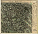
Historical maps
- Rassach and the surrounding area from the three regional surveys in the period from approx. 1789 to 1910

Rassach as "Rosseck" in the Josephinische Landesaufnahme , around 1780

In the east of Rassach
In the Franziszeische Landesaufnahme , approx. 1835

Recording sheet 1: 25,000 from the state survey around 1878
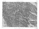
In the francisco-josephine land survey , approx. 1910


Individual evidence
- ^ Styrian municipal structural reform .
- ↑ Section 3, Paragraph 2, Item 5 of the Act of December 17, 2013 on the reorganization of the municipalities of the State of Styria ( Styrian Municipal Reform Act - StGsrG). Provincial Law Gazette for Styria of April 2, 2014. No. 31, year 2014. ZDB -ID 705127-x . P. 2.
- ↑ Brigitta Mader: The Alpine Slavs in Styria. A toponomastic-archaeological investigation. Writings of the Balkan Commission, Linguistic Department, Volume 31. Austrian Academy of Sciences, OeAW, Philosophical-Historical Class. Verlag der ÖAW, Vienna 1986. ISBN 3-7001-0769-2 . Pp. 9-10.
- ↑ Brigitta Mader: Alpenslawen. P. 36 (Graschuh), P. 53 (Lasselsdorf), P. 82 (Rassach).
- ^ Fritz Lochner von Hüttenbach: Styrian place names. On the origin and interpretation of names of settlements, mountains, waters and fields. In the series: Graz comparative works. Volume 21. Verlag Leykam, Graz 2008. ISBN 978-3-7011-0116-0 . P. 153.
- ^ District topography : Helmut-Theobald Müller (ed.), Gernot Peter Obersteiner (overall scientific management): History and topography of the Deutschlandsberg district. Graz-Deutschlandsberg 2005. ISBN 3-90193815X . Styrian Provincial Archives and District Authority Deutschlandsberg 2005. In the series: Great historical regional studies of Styria. Founded by Fritz Posch †. Second part of the Bezirkslexikon. P. 348.
- ↑ a b District Court of Stainz. Land register of the cadastral community 61212 Graschuh, deposit number 65.
- ↑ Walter Brunner: The Gmein in the Styrian Altsiedelland. In: Gerhard Pferschy: settlement, power and economy. Festschrift Fritz Posch for his 70th birthday. Publications of the Styrian regional archive. Volume 12. Graz 1982. No ISBN. Pp. 45-50.
- ↑ Announcement of the agricultural district authority for Styria of July 3, 2018 on the conclusion of the procedure. Grazer Zeitung. 27. Issue , issued July 6, 2018. Volume 214, Graz 2018. ZDB -ID 1291268-2 p. 305.
- ↑ Werner Murgg, Bernhard Hebert: Medieval and early modern fortifications in the district of Deutschlandsberg: recording of the soil monuments. With drawings by Stefan Karl. Contributions to medieval archeology in Austria BMÖ. Volume 10, born in 1994. Ed .: Austrian Society for Medieval Archeology ÖGM, Vienna. ISSN 1011-0062 . Pp. 67-68.
- ^ Chronicle of the Rassach elementary school (from www.volksschule.rassach.at , accessed on May 10, 2012)
- ↑ Gerald M. Wolf: "Now we are the gentlemen ..." The NSDAP in the Deutschlandsberg district and the 1934 July putsch (= Grazer Zeitgeschichtliche Studien, Volume 3) StudienVerlag, Innsbruck-Wien-Bozen 2008, p. 149, footnote 324, ISBN 978-3-7065-4006-3 .
- ↑ Law of December 18, 1967 on territorial changes of municipalities , Provincial Law Gazette for Styria of December 29, 1967, Part 26, No. 138, p. 188.
- ^ Kurt Woisetschläger, Peter Krenn: Dehio manual. The art monuments of Austria. Styria (excluding Graz). Topographical inventory of monuments, published by the Federal Monuments Office. Vienna 1982. ISBN 3-7031-0532-1 . Pp. 390-391.
- ↑ Winfried Bräunlich, Dieter Weiss: Signs on the way. Religious small monuments in the communities Georgsberg, Rassach, Stainztal and Stallhof. Simadruck Deutschlandsberg. Stainz 2012. p. 77 (Riegelanderlkapelle) and p. 95 (Hartschiebl-Marienstatue).
- ↑ Brownish, white: characters . Pp. 61-119.
- ↑ Brownish, white: characters . P. 88.
- ↑ Brownish, white: characters . Pp. 113–114 and p. 205. Location: Property no. 1245, deposit number 279, KG 61233 Rassach. Coordinates 46 ° 51 '57 " N , 15 ° 15' 45" O
- ^ Weekly newspaper Weststeirische Rundschau. May 23, 2014. Volume 87, No. 21. ZDB -ID 2303595-X . P. 1.
- ↑ Opening of the park + pray chapel .
- ↑ Planning of the chapel (with picture). Published January 9, 2012, archived from the original on May 25, 2014 . .
- ↑ Ordinance of the District Commission of Deutschlandsberg of December 19, 1986 on the declaration of an alluvial forest residue in the KG. Herbersdorf to the nature reserve (plant protection area). Grazer Zeitung, Official Gazette for Styria. Born in 1987. ZDB -ID 1291268-2 p. 51.
- ↑ Information page of the office of the Styrian state government.

Bad Schwanberg | Deutschlandsberg | Eibiswald | Frauental an der Laßnitz | Great Saint Florian | Lannach | Pölfing-Brunn | Preding | Sankt Josef (West Styria) | Sankt Martin im Sulmtal | Sankt Peter im Sulmtal | Sankt Stefan ob Stainz | Stainz | Wettmannstätten | Wies
93 Former communities (dissolved since 1945):
Aibl |
Aigen |
Bad Gams |
Blumegg |
Breitenbach in West Styria |
Dietmannsdorf im Sulmtal |
Ettendorf near Stainz |
Feisternitz |
Field tree |
Freidorf an der Laßnitz |
Open field near Deutschlandsberg |
Gamsgebirge |
Garanas |
Gasselsdorf |
Georgsberg |
Gersdorf |
Grafendorf near Stainz |
Graggerer |
Grass shoe |
Greisdorf |
Greith |
Gressenberg |
Großradl |
Grub near Groß Sankt Florian |
Grünau an der Laßnitz |
Gundersdorf |
Gussendorf |
Hasreith |
Herbersdorf |
Hollenegg |
Kleinradl |
Monastery |
Kornriegl |
Kothvogel |
Kraubath (West Styria) |
Krottendorf an der Laßnitz |
Kruckenberg |
Laaken |
Lasselsdorf |
Lebing |
Limberg near Wies |
Mainsdorf |
Marhof |
Mettersdorf |
Michlgleinz |
Nassau |
Neudorf near Stainz |
Neurath |
Niedergams |
Oberhart |
Upper Latin |
Oisnitz |
Osterwitz |
Otternitz |
Petzelsdorf in West Styria |
Pichling at Stainz |
Pirkhof |
Pitschgau |
Rassach |
Rossegg |
Rostock |
Red wine |
Sankt Oswald ob Eibiswald |
Sankt Ulrich in Greith |
Schönaich |
Sierling |
Soboth |
Stainztal |
Stable yard |
Stammeregg |
Sterglegg |
Sulmeck-Greith |
Sulz |
Sulz-Laufenegg |
Tanzelsdorf |
Teipl |
Tobis |
Tobisegg |
Trahütten |
Trough |
Unterbergla |
Vochera am Weinberg |
Vochera an der Laßnitz |
Front village |
Forest in West Styria |
Wernersdorf |
Wetzelsdorf in West Styria |
Wielfresen |
Wieselsdorf |
Torrent |
Wohlsdorf |
Zeierling |
Zirknitz