
Mooskirchen
|
market community Mooskirchen
|
||
|---|---|---|
| coat of arms | Austria map | |
 |
|
|
| Basic data | ||
| Country: | Austria | |
| State : | Styria | |
| Political District : | Voitsberg | |
| License plate : | VO | |
| Surface: | 17.97 km² | |
| Coordinates : | 46 ° 59 ' N , 15 ° 17' E | |
| Height : | 380 m above sea level A. | |
| Residents : | 2,207 (January 1, 2020) | |
| Postal code : | 8562 | |
| Area code : | 03137 | |
| Community code : | 6 16 15 | |
| NUTS region | AT225 | |
| Address of the municipal administration: |
Marktplatz 4 8562 Mooskirchen |
|
| Website: | ||
| politics | ||
| Mayor : | Engelbert Huber ( ÖVP ) | |
|
Municipal Council : (2015) (15 members) |
||
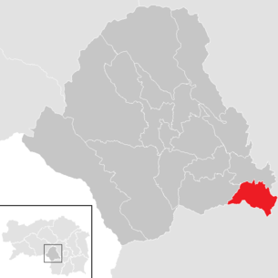
| Location of Mooskirchen in the Voitsberg district | ||
  |
||
| Source: Municipal data from Statistics Austria | ||

Mooskirchen is a market town with 2207 inhabitants (as of January 1, 2020) in the judicial district or district of Voitsberg in western Styria .
Geographical location
Mooskirchen is located southwest of Graz .
Community structure

The municipal area comprises nine localities (population in brackets as of January 1, 2020):
- Bubendorf (58)
- Fluttendorf (286)
- Giessenberg (255)
- Kniezenberg (244)
- Mooskirchen (617)
- Neudorf near Mooskirchen (101)
- Rauchegg (160)
- Rubmannsberg (127)
- Stögersdorf (359)
The community consists of five cadastral communities (area: as of December 31, 2018):
- Fluttendorf (386.00 ha)
- Giessenberg (258.39 ha)
- Mooskirchen (136.98 ha)
- Neudorf near Mooskirchen (197.04 ha)
- Stögersdorf (818.84 ha)
Incorporations
- On January 1, 1948, the independent community of Neudorf bei Mooskirchen was incorporated into Fluttendorf.
- On January 1, 1968, the independent communities of Fluttendorf, Gießenberg and Stögersbach were incorporated into Mooskirchen.
history
The earliest written document is from 1180 and reads "Mosekirchen". The name goes back to old high German mos (swamp) and describes a place of worship in a swampy environment.
Winterhof Castle, built in the 14th century, was demolished in 1784, and Gilgenbühel Castle, which had existed since around 1580, existed until the end of the 18th century.
In the years around 1970 there was a small field railway in Mooskirchen that had been laid out by Mr. Valdo Longo. It was later brought to Edelsbach near Feldbach and sold to Stainz in 2006, where it was incorporated into the existing facility next to Stainz train station . One of the locomotives was a JW 20 that Longo had acquired in 1968.
Culture and sights

Site design
As part of the European “ Entente Florale Europe ” competition, Mooskirchen was awarded a gold medal in the village category on September 24, 2009.
politics
coat of arms
The municipal coat of arms was awarded with effect from August 1, 2007. The blazon (coat of arms description) reads:
- In a green shield over a black shield base and a lowered silver, black-flooded corrugated beam, a silver church with two arched windows and an attached choir room on the right, the steeple with a pointed roof, two tall rectangular windows and black openwork arched portal on the left, separated on the right by a silver tripod kettle.

The former municipality of Stögersdorf was given a municipal coat of arms with effect from October 1, 1953, the blazon read:
- A split shield. The front red field is crossed by a stylized golden bar, the rear silver field by three black diagonal bars.
Personalities
Honorary citizen
- 1986: Josef Krainer (1930–2016), Governor 1980–1996
Sons and daughters of the church
- Herbert Pirker (* 1981), jazz musician
Personalities associated with the community
- Matthias Konrad (* 1943), SPÖ politician , Mayor of Leoben 1994–2014
- Andreas Thom (1884–1943), writer
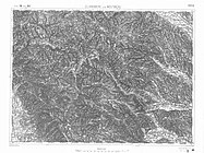
Historical maps
- The area of Mooskirchen and its surroundings in the regional surveys from approx. 1789 to 1910

Mooskirchen in the Josephinische Landesaufnahme around 1790
Franzisco-Josephinische Landaufnahme , ca.1910

Middle course of the Kainach, recording sheet 1: 25,000 of the state survey around 1878

Stainz, Rosenkogel, Reinischkogel , 1877/78


Individual evidence
- ↑ Statistics Austria: Population on January 1st, 2020 by locality (area status on January 1st, 2020) , ( CSV )
- ↑ CSV file from REGIONALINFORMATION.zip (1,221 kB) ; accessed on January 12, 2019
- ↑ LGBL. No. 041/1947
- ↑ LGBL. No. 138/1967
- ↑ Fritz Frhr. Lochner von Hüttenbach: On the name property of the early Middle Ages in Styria (= magazine of the Historical Association for Styria . Volume 99 ). Böhlau Verlag, Vienna 2008, p. 55 ( historerverein-stmk.at [PDF; 16.9 MB ]).
- ↑ Manfred Hohn: 43. The field railway of Dr. Valdo Longo in Edelsbach. In: Feldbahnen in Austria. Leykam, Graz 2011. ISBN 978-3-7011-7766-0 . Pp. 285-287.
- ^ Andreas Christopher: Jenbacher works - Jenbacher JW20 . Factory number 2134, year of construction 1954, track 600 mm, wheel arrangement B, power 20 HP, weight 3.8 tons with lighting system and roof. First owner Steyr Daimler Puch .
- ↑ State Law Gazette Styria No. 64/2007
- ↑ LGBL. 1953, 13th item, No. 42.
Web links
- 61615 - Mooskirchen. Community data, Statistics Austria .
- www.mooskirchen.at Website of the market town of Mooskirchen
Cadastral communities: Fluttendorf | Giessenberg | Mooskirchen | Neudorf near Mooskirchen | Stögersdorf
Locations: Bubendorf | Flood Village | Giessenberg | Kniezenberg | Mooskirchen | Neudorf near Mooskirchen | Rauchegg | Rubmannsberg | Stögersdorf
Market place: Mooskirchen • Villages: Fluttendorf | Stögersdorf • Rotten: Bubendorf | Edenberg | Giessenberg | Kniezenberg | Loreith | Neudorf near Mooskirchen | Rauchegg | Rosenberg | Rubmannsberg | Ungerbach
Scattered houses: Gersdorf
Other locations: Fladersbach | Fromi | Grabenjosl | Suppi | Gasthaus Treitlerwirt
Counting district: Fluttendorf | Giessenberg | Mooskirchen | Stögersdorf
