
Modriach
|
Modriach ( village ) locality cadastral municipality Modriach |
|||
|---|---|---|---|
|
|||
| Basic data | |||
| Pole. District , state | Voitsberg (VO), Styria | ||
| Judicial district | Voitsberg | ||
| Pole. local community | Precious scrap | ||
| Coordinates | 46 ° 57 '26 " N , 15 ° 3' 37" E | ||
| height | 1009 m above sea level A. | ||
| Residents of the village | 212 (January 1, 2020) | ||
| Building status | 147 (2001) | ||
| Area d. KG | 21.97 km² | ||
| Post Code | 8583 | ||
| Statistical identification | |||
| Locality code | 16182 | ||
| Cadastral parish number | 63340 | ||
| Counting district / district | Modriach (61 627 002) | ||
| Separate municipality until the end of 2014 (GKZ 61614; ZSpr 61,614,000th.) Source: STAT : Gazetteer ; BEV : GEONAM ; GIS-Stmk |
|||

Modriach is a place in the Koralpe in Styria as well as a locality and cadastral municipality of the municipality of Edelschrott in the Voitsberg district .
The former municipality with 212 inhabitants (as of January 1, 2020) has been incorporated into the market town of Edelschrott since January 1, 2015 as part of the municipal structural reform in Styria .
geography
Modriach is located southwest of Graz in the Styrian Rand Mountains , in the north of the Koralpe on the border with the Packalpe . The place is on the Modriachbach , which rises at the Hebalm and flows into the Packer Bach .
Modriach consists of only one cadastral municipality , which bears the same name as the municipality and includes the upper reaches of the Modriachbach and its headwaters. The municipality has remained unchanged in its boundaries since the 18th century. In the south of the village, in the Packwinkel district, lies the Hebalm with the ski area of the same name, and in the southwest the Reinischkogel . However, these areas cannot be reached from Modriach via public roads, but only via forest and hiking trails.
history


The mother parish of the area was the parish Piber , which was looked after from the 12th century until 1786 by the St. Lambrecht monastery . The area of the St. Lambrecht Monastery was formally part of the Diocese of Seckau, but had extensive special rights.
In the 15th and 16th centuries, after the quarter division of Styria in 1462 , Pack was initially in the area of Upper Styria in the quarter enhalb the Piberalm and there in the Judenburg quarter . The Kainach Valley as far as Ligist and Lieboch , Übelbach and Thal to the west of Graz also belonged to this quarter . In 1677 the Kainach Valley and its surroundings, including the area of Modriach, were separated from the Judenburg district and moved to the district between Mur and Traa (Drau), the predecessor of the Marburg district . The community initially remained in this quarter of Styria even after the territorial reforms under Maria Theresa and Joseph II . From November 1, 1783, the Kainachtal came from the Marburger Kreis to the Grazer Kreis , the southern municipality boundary of Modriach became the district boundary.
In the 16th and 17th centuries, the municipality belonged to the " Burgfried der Ämter Pack, Hirscheck and Modriach" for the lower jurisdiction and to the regional court of Voitsberg-Greißenegg of the Obervoitsberg estate for the higher (blood) jurisdiction . However, this only applied outside the eaves : within it, the full lower jurisdiction lay with the respective landlord in the 16th century.
From 1770, when people and houses were recorded for the first time in Austria , people, migrating cattle and houses from Modriach are recorded independently. This registration took place within the framework of the army reforms under Maria Theresa and Joseph II . It led to the introduction of the " numbering sections " (also called Konskriptionsgemeinden). Modriach was one such section. Together with the numbering section Pack, Modriach belonged to the western part of the Ligist advertising district . In the years that followed, the numbering section became the tax municipality and cadastral municipality of the same name Pack.
The community emerged from the cadastral community in 1850 without changing its territory. The neighboring communities of Modriach were recently Edelschrott in the east and north , Kloster in the south and Pack in the west .
Economy and Infrastructure
Traffic connections lead north via secondary roads to Packer Strasse and the Modriach exit of the Südautobahn . The community is connected to Köflach by a school bus on line 722 of the Styrian transport association. This line is operated by GKB ; there are no other public transport connections.
The place is of regional importance as a hiking and skiing area, and several mountain bike and cross-country skiing tours also lead through the municipality. The Schrogentor on the southern border is a prominent waypoint.
The Modriach parish forms a parish of the Graz-Seckau diocese . This parish is no longer occupied by its own priest, but belongs to the parish association Köflach , Pichling bei Köflach , Hirschegg , Modriach and Pack .
Culture and sights
Here are some small sites of tourmaline , epidote , beryl , titanite , zircon , cassiterite and spodumene .
Personalities
Honorary citizen
- 1977: Franz Wegart (1918–2009), Deputy Governor
- 1984: Josef Krainer (1930–2016), governor
Sons and daughters of the church
- Johann Neumann (1929–2013), politician as well as innkeeper and farmer
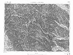
Historical maps
- Historical maps of Modriach from the three country surveys , approx. 1789 to 1910
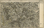
The area of Modriach (far left) in the Josephinische Landesaufnahme , approx. 1789

The west of Modriach in the Franziszeische Landesaufnahme , approx. 1835
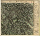
eastern part of Modriach around 1835

Recording sheet of the Francisco-Josephinian land survey , approx. 1877/78
Modriach (top center), special map around 1910


Web links
- 61614 - Modriach. Community data, Statistics Austria .
- Official website - www.modriach.at
- www.Modriach.com - The community / The residents
Individual evidence
- ↑ Statistics Austria: Population on January 1st, 2020 by locality (area status on January 1st, 2020) , ( CSV )
- ↑ Announcement of the Styrian state government of October 24, 2013 on the union of the market community Edelschrott and the community Modriach, both political district Voitsberg. Styrian Provincial Law Gazette of November 15, 2013. No. 125, 32nd issue. ZDB ID 705127-x . P. 633.
- ^ Anton Mell: High and lower criminal jurisdictions. Regional courts and truces in Styria. In: Anton Mell, Hans Pirchegger: Styrian court descriptions . As sources for the Historical Atlas of the Austrian Alpine Countries. I. Department. District court map: Styria. In the series: Sources on the constitutional and administrative history of Styria. I. Volume. Published by the Historical State Commission for Styria. Graz 1914. General: Pages XX – XLIV. To the keep: page 229 .
- ^ Mell: Criminal Courts , Page XXVI.
- ↑ Manfred Straka: Administrative boundaries and population development in Styria 1770-1850. Explanations for the first delivery of the Historical Atlas of Styria. Research on the historical regional studies of Styria, XXXI. Tape. Published by the Historical Commission for Styria - HLK. Self-published by HLK. Graz 1978. Pages 207.
- ^ Manfred Straka: Numbering sections and advertising districts of Styria 1779/81. Maps on a scale of 1: 300,000. In: Historical Atlas of Styria . Published by the Historical Commission for Styria - HLK. Academic printing and publishing company. Graz 1977 1st delivery: Administrative boundaries and population development in Styria 1770–1850. Sheet 2 (sheet north).
- ^ Manfred Straka: Tax communities and advertising districts of Styria 1798–1810. Maps on a scale of 1: 300,000. In: Historical Atlas of Styria . Published by the Historical Commission for Styria - HLK. Academic printing and publishing company . Graz 1977. 1st delivery: Administrative boundaries and population development in Styria 1770–1850. Sheet 4 (sheet north)
- ^ Manfred Straka: cadastral communities and advertising districts of Styria 1818–1848. Maps on a scale of 1: 300,000. In: Historical Atlas of Styria . Published by the Historical Commission for Styria - HLK. Academic printing and publishing company. Graz 1977. 1st delivery: Administrative boundaries and population development in Styria 1770–1850. Sheet 6 (sheet north).
- ↑ Leopold Weber (Ed.): Handbook of the deposits of ores, industrial minerals and energy resources of Austria. Explanations of the metallogenetic map of Austria 1: 500,000 including industrial minerals and energy resources. Archive for deposit research Volume 19 Vienna 1997. Federal Geological Institute ISBN 3-900312-98-2 ISSN 0253-097X . Page 317. ( PDF , 43 MB)

Cadastral communities: Edelschrott | Kreuzberg | Modriach
Localities Edelschrott | Kreuzberg | Modriach • Market place: Edelschrott • Village: Modriach • Rotte Stampf
Scattered Houses: Grail | Herzogberg | Kreuzberg | Mitterberg | Middle Herzogberg | Upper Herzogberg | Upper Modriachwinkel | Saint Hemma | Lower Modriachwinkel | Wöllmiß
Other locations: Adambauer | Gasthaus Aiblwirt | Beutler | Blochwirt Inn | Blümelhans | Brandstätter | Brunner | Derler | Draxler Inn | Draxler | Ebenlecker | Ehrenbauer | Butchershackers | Franzbauer | Friedl | Geidl | Geidlandrä | Goessler | Gratzjörgl | Gratzn | Gregerbauer | Göri | Guggi | Guggimörth | Hunting lodge Hahnenschloss | Hansbauer | Hanserveit | Hibler | Gasthaus Hirzmann | Hofbauernveitl | Hollow | Gasthaus Hoiswirt | Hörmann (near Hirzmann reservoir) | Hörmann (at the Packer reservoir) | Hunter host | Jodlbauer | Kappler | Karnerbauer | Chaste | Klamet | Klinger | Kogelweber | Delicious | Delicious fastl | Lips Peter | Madlbauer | Marcher | Nöstler | Oberländer | Ödenschanz | Pabst | Pope | Penz | Penzulli | Pfennich | Pfennighube | Pöschllenz | Pöschlmax | Rain grinder | Reinischtoni | Rössl | Rössltoni | Scheerhans | Sheikh | Scherrandrä | Scherveitl | Schmiedjaklmichl | Schmolli (in Oberer Herzogberg) | Schmolli (in Unterer Herzogberg) | Schober | Spenger | Lock pack | Steinbauer | Steinwendler | Steinwendler | Tallow | Ulz | Lower Sorger | Walchbauer | Gasthaus Wartinger | White | Weßveit | Angle grinder | Peoples | Ziery | Ziery | Twenties
Counting area: Edelschrott -Ort | Precious scrap environment | Modriach