
Packer Street

| State road B70a in Austria | ||||||||||

|
||||||||||
| Basic data | ||||||||||
| Overall length: | 1.5 km | |||||||||
|
State : |
||||||||||
|
Course of the road
|
||||||||||
| State road B70b in Austria | ||||||||||

|
||||||||||
| Basic data | ||||||||||
| Overall length: | 1.0 km | |||||||||
|
State : |
||||||||||
|
Course of the road
|
||||||||||
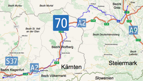

The Packer Street B 70 is a main road in Austria . It runs in the federal states of Styria and Carinthia and is 157.7 km long. Before the south autobahn was built, it was the best way to get from Graz to Klagenfurt .
history
By a resolution of the Styrian state parliament on February 13, 1896, the road from Köflach to Hasendorf, Edelschrott and Pack was upgraded to a district road, first class.
The packaging line has been adopted in accordance with Federal Law of July 15, 1930 by the federal government and federal road moderately expanded. This newly built east-west connection was ceremoniously opened on May 31, 1936. Until 1938 Packer Straße was designated as B 25, after the connection of Austria , Packer Straße was part of Reichsstraße 333 until 1945 .
Course and description of the route
It leads from Graz via Lieboch , Voitsberg , Köflach to the Styrian border on the Packsattel (1,169 m). In Carinthia, it continues through Frantschach-Sankt Gertraud , Wolfsberg , St. Andrä , over the Brennerberg, Griffen and Völkermarkt to Klagenfurt.
In Graz, Packer Straße begins at the large traffic light intersection with Grazer Straße B 67. The local street name in Graz is Kärntner Straße . A few meters later, the road passes under the southern runway with the Koralm railway , which is currently under construction (as of 2017). In this area up to the intersection with Peter-Rosegger- Strasse, the B 70 has been expanded to four lanes. Further out of town is the connection to the Pyhrn Autobahn A 9. The road then crosses the communities of Seiersberg-Pirka and Haselsdorf-Tobelbad .
In the municipality of Lieboch , the Radlpass Straße B 76 branches off at a roundabout . From this intersection to the Mooskirchen junction , the state road runs parallel to the A 2 south autobahn . Starting at the roundabout at this junction, the B 70 is the main feeder road to the cities of Voitsberg and Köflach. The volume of traffic is correspondingly high.
In 2005 the bypass for the municipality of Krottendorf-Gaisfeld was opened. A roundabout was built at the beginning and end of the new street. The previous section of the B 70 in this area has been declared a private road for the State of Styria .
Following this bypass in the direction of Carinthia there are the so-called Kremser rows (named after the nearby town of Krems ). This refers to the winding route, which has two lanes in each direction and is located on both banks of the Kainach . In 2005 local politicians wanted to downgrade the street into two streets, each with one lane in each direction. The reason for this was the frequency of accidents in this section. A citizens' initiative prevented this project again. Instead, more and more speed controls are being carried out there.
The Voitsberg bypass follows, some of which is an underground route. The B 70 continues in four lanes through a commercial and business area and the community of Rosental an der Kainach . The best-developed section of Packer Strasse then follows between Rosental and Köflach, with two lanes in each direction and a central separation. However, there are some level crossings on the route, which are very lightly frequented. The Köflach bypass that follows, on the other hand, has only level crossings, but is only two-lane.
After Köflach in the direction of Klagenfurt, Gaberl Straße B 77 branches off from Packer Straße at a traffic light-controlled intersection. In the further course the B 70 has the character of a mountain road and leads through the communities Edelschrott and Hirschegg-Pack over the Packsattel to Carinthia and there through the community Preitenegg .
In Twimberg, a cadastral municipality of Bad St. Leonhard , Obdacher Straße B 78 begins on Packer Straße. Then the road leads through Frantschach-Sankt Gertraud , Wolfsberg and St. Andrä through the Lavant Valley . In Wolfsberg, the B 70a (Wolfsberg / South junction) and the B 70b (Wolfsberg / North junction) branch off the road, each connecting Packer Straße with the Wolfsberg Süd and Wolfsberg Nord junctions on the Südautobahn.
From St. Andrä over the Griffner Berg there are many bends . Numerous uphill stretches are two-lane in this section. This was necessary before the construction of the Südautobahn for Packer Strasse, as trucks only crawl the steep path over Griffner Berg at a slow pace. Between the municipality of Griffen and the Völkermarkt Ost junction, the road runs along the motorway a few meters away. In the municipality of Völkermarkt, first the Lavamünder Straße B 80 branches off from Packer Straße in the direction of Klagenfurt , and then Seeberg Straße B 82 crosses the B 70, both of which share a short stretch of the road.
According to plans, the new Völkermarkter west bypass should branch off from Packer Strasse to the west of Völkermarkt. This construction project also includes the expansion of the busy road between Völkermarkt and the A 2 junction Völkermarkt West, including leveling-out expansion.
Since the south autobahn between Völkermarkt West and Klagenfurt was built relatively late (opening November 25, 1999), Packer Strasse between this junction and Klagenfurt is very well developed. There are two lanes in each direction, but there are numerous level crossings. The route was notorious for numerous serious traffic accidents, especially head-on collisions occurred due to a lack of center separation. Since the opening of the motorway, the volume of traffic has fallen sharply, and the route has been reduced in sections or provided with large traffic islands.
In Klagenfurt, Packer Strasse is four-lane throughout, it leads from the city limits to the Ring and then as part of the Völkermarkter and St. Veiter Ring to Kärntner Strasse B 83.
swell
- ↑ Announcement by the Imperial and Royal Governor of Styria from April 22, 1896. LGBl. No. 33/1896.
- ^ Federal law of July 15, 1930, which declares the Graz-Köflach-Packsattel-Twimberg (Packstrasse) road to be a federal road.
- ↑ The Packer Höhenstraße is ready. In: Das Kleine Blatt , May 14, 1936, p. 6 (online at ANNO ).
| B70 | Like the other former federal highways, Packer Strasse was part of the federal administration. Since April 1, 2002, it has been under state administration and continues to have the B in the number, but not the name Bundesstraße. |