
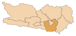
Klagenfurt-Land district
| location | |
|---|---|
  |
|
| Basic data | |
| state | Carinthia |
| NUTS III region | AT-211 |
| Administrative headquarters | Klagenfurt am Wörthersee |
| surface | 766 km² |
| Residents | 60,014 (January 1, 2020) |
| Population density | 78 inhabitants / km² |
| License Plate | KL |
| website | www.bh-klagenfurt.ktn.gv.at |
| map | |
  |
|
The Klagenfurt-Land district is a political district in the Austrian state of Carinthia .
Administrative division
The Klagenfurt-Land district is divided into 19 municipalities , including one municipal municipality and eight market municipalities . The number of inhabitants as of January 1, 2020 are in brackets.
|
Legend for the breakdown table
|

| local community | Slovenian | location | Ew | km² | Ew / km² | Judicial district | region | Type | Metadata |
|---|---|---|---|---|---|---|---|---|---|
Ebenthal in Carinthia
|
Žrelec |

|
8,065 | 55 | 147 | Klagenfurt | market community |
According to code: 20402 |
|
Feistritz in the Rosental
|
Bistrica v Rožu |

|
2,474 | 71.84 | 34 | Ferlach | Rose Valley | market community |
According to code: 20403 |
Ferlach
|
Borovlje |

|
7.123 | 117.31 | 61 | Ferlach | Rose Valley | urban community |
Acc. To code: 20405 |
Grafenstein
|
Grabštanj |

|
2,969 | 50.19 | 59 | Klagenfurt | market community |
Acc. To code: 20409 |
|
Keutschach am See
|
Hodiše ob jezeru |

|
2,440 | 28.37 | 86 | Klagenfurt | local community |
According to code: 20412 |
|
Köttmannsdorf
|
Kotmara vas |

|
3,079 | 28.19 | 109 | Klagenfurt | local community |
According to code: 20414 |
|
Krumpendorf am Wörthersee
|
Kriva Vrba |

|
3,453 | 11.85 | 291 | Klagenfurt | local community |
According to code: 20415 |
|
Ludmannsdorf
|
Bilčovs |

|
1,784 | 26.36 | 68 | Klagenfurt | local community |
According to code: 20416 |
|
Magdalensberg
|
Štalenska gora |

|
3,529 | 42.88 | 82 | Klagenfurt | market community |
Acc. To code: 20442 |
|
Maria Rain
|
Žihpolje |

|
2,561 | 25.52 | 100 | Klagenfurt | local community |
According to code: 20417 |
|
Maria Hall
|
Gospa Sveta |

|
3,864 | 34.84 | 111 | Klagenfurt | market community |
According to code: 20418 |
|
Maria Wörth
|
Otok |

|
1,608 | 17.41 | 92 | Klagenfurt | local community |
According to code: 20419 |
|
Moosburg
|
Možberk |

|
4,478 | 36.76 | 122 | Klagenfurt | market community |
According to code: 20421 |
|
Poggersdorf
|
Pokrče |

|
3,199 | 30.75 | 104 | Klagenfurt | market community |
According to code: 20425 |
|
Pörtschach am Wörther See
|
Poreče ob Vrbskem jezeru |

|
2,885 | 12.64 | 228 | Klagenfurt | local community |
According to code: 20424 |
|
Sankt Margareten im Rosental
|
Šmarjeta v Rožu |

|
1,084 | 43.97 | 25th | Ferlach | Rose Valley | local community |
According to code: 20428 |
Schiefling on Lake Wörthersee
|
Škofiče |

|
2,630 | 28.61 | 92 | Klagenfurt | market community |
According to code: 20432 |
|
Techelsberg am Wörther See
|
Teholica ob Vrbskem jezeru |

|
2,178 | 28.37 | 77 | Klagenfurt | local community |
According to code: 20435 |
|
Cell
|
Sele |

|
611 | 75.44 | 8.1 | Ferlach | local community |
According to code: 20441 |
population


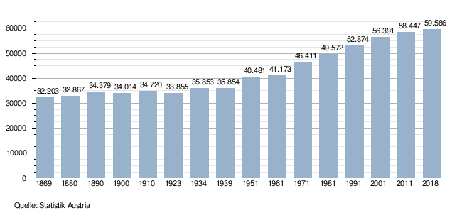
The Klagenfurt Land district has 59,586 inhabitants (as of 2018). The Karawanken in the south, the Drau and the Wörther See are characteristic of the landscape . The most important work center is the own district of Klagenfurt Stadt, Ferlach is also an important center for the labor market. Tourism is important for the places around Lake Wörth.
Population development
Income, unemployment
The average income in the district is well below the average for Austria and also below that of Carinthia. The unemployment rate is almost identical to that of Austria and well below that of Carinthia.
 |
 |
education
The trend towards higher education is also evident in the Klagenfurt Land district. The low proportion of compulsory school leavers and the above-average proportion of people with high school diplomas and university degrees are particularly striking :
 |
 |
 |
economy
In the district of Klagenfurt Land, the wood processing industry is an important employer, as is the mineral oil processing, chemical and pharmaceutical industries. The second important economic factor is tourism , especially in the communities on the Wörther See and the Keutschacher See.
Economic structure
The service sector is very pronounced , with tourism in particular playing a central role. There are relatively few large companies in the district, small and very small companies are of great importance.
 |
 |
Agriculture and Forestry
The Klagenfurt Land district had 16,203 cattle in 2017, which is less than 9% of the Carinthian herd. The logging was also below the Carinthian average with 258,000 solid meters .
Industry, manufacturing, manufacturing of goods
The industrial companies with the most employees in the Klagenfurt Land district are (as of 2016): Glock GmbH , Kostwein Maschinenbau GmbH , Bäckerei Wienerroither GmbH, Magna Auteca AG , Selida Krismayer GmbH.
The communities with the most farms are Ferlach and Ebenthal. Ferlach uses its proximity to Slovenia and has successful companies in the gunsmith sector, such as the market leader Glock GmbH and Hambrusch Jagdwaffen GmbH. Since 1990, the municipality of Ebenthal has been able to relocate forty companies to a new industrial zone using a company settlement model.

Number of establishments per municipality


tourism
Tourism plays an important role for the communities on the lakes. While guests from abroad predominate at the Wörther See, more than 60% are Austrians on the Keutschacher See.

Overnight stays in the tourism year 2017 (in thousands)

Infrastructure / traffic
- Railway: The central train station is located in the Klagenfurt Stadt district, but the Klagenfurt Land district also has excellent rail connections: the Südbahn , which runs from Vienna to Klagenfurt and on to Villach , is the main connection. There is also the Drautalbahn east to Wolfsberg and Dravograd , as well as a branch line south to Weizelsdorf with goods transport to Ferlach.
- Road: The Klagenfurt Land district is well connected to the north, east and west via the Süd Autobahn and the S37 expressway . The B71 federal road leads south over the Loibl Pass to Slovenia.
Web links
Individual evidence
- ↑ Statistics Austria - Population at the beginning of 2002–2020 by municipalities (area status 01/01/2020)
- ↑ a b AMS job market profile Klagenfurt. 2016, accessed February 27, 2019 .
- ↑ a b c WIBIS Carinthia, district profile Klagenfurt Land. 2017, accessed February 27, 2019 .
- ↑ Statistics Austria, educational level of the population aged 25 to 64 by district. 2016, accessed February 27, 2019 .
- ^ Economic Association of Carinthia, Klagenfurt Land district. Retrieved February 27, 2019 .
- ^ Province of Carinthia, Agriculture Report. 2017, accessed February 27, 2019 .
- ^ City of Ferlach, Economy. Retrieved February 27, 2019 .
- ^ Community Ebenthal, business directory. Retrieved February 27, 2019 .
- ↑ Statistics Austria, workplaces and companies, average number of employees per workplace, municipalities. October 31, 2016, accessed February 27, 2019 .
- ↑ Carinthia, S042 nights. 2017, accessed February 27, 2019 .
Coordinates: 46 ° 33 ' N , 14 ° 15' E