
Ludmannsdorf
|
Ludmannsdorf
Bilčovs |
||
|---|---|---|
| coat of arms | Austria map | |
 |
|
|
| Basic data | ||
| Country: | Austria | |
| State : | Carinthia | |
| Political District : | Klagenfurt-Land | |
| License plate : | KL | |
| Surface: | 26.36 km² | |
| Coordinates : | 46 ° 32 ' N , 14 ° 8' E | |
| Height : | 564 m above sea level A. | |
| Residents : | 1,784 (January 1, 2020) | |
| Population density : | 68 inhabitants per km² | |
| Postal code : | 9072 | |
| Area code : | 04228 | |
| Community code : | 2 04 16 | |
| NUTS region | AT211 | |
| Address of the municipal administration: |
No. 27, 9072 Ludmannsdorf | |
| Website: | ||
| politics | ||
| Mayor : | Manfred Maierhofer (CEO) | |
|
Municipal Council : ( 2015 ) (15 members) |
||
| Location of Ludmannsdorf Bilčovs in the Klagenfurt-Land district |
||
  |
||
| Source: Municipal data from Statistics Austria | ||

Ludmannsdorf ( Slovenian : Bilčovs ) is a bilingual municipality with 1784 inhabitants (as of January 1, 2020) in Carinthia . The community is located in the Rosental between the Wörthersee and the Drau .
geography
The municipality of Ludmannsdorf extends north of the Drau and south of the Wörthersee between the municipalities of Velden am Wörther See and Köttmannsdorf . It lies on the heavily wooded range of hills of the Sattnitz , a terminal moraine from the Ice Age, and overlooks the Rosental and Karawanken mountains . The altitude of the municipality is between 600 and 900 meters.
Community structure
Ludmannsdorf consists of the five cadastral communities Ludmannsdorf ( Bilčovs ), Großkleinberg ( Mala gora ), Oberdörfl ( Zgornja Vesca ), Selkach ( Želuče ) and Wellersdorf ( Velinja vas ). The municipality includes the following 17 localities (population as of January 1, 2020):
- Bach ( Potok ) (87)
- Edling ( Kajzaze ) (170)
- Fellersdorf ( Bilnjovs ) (50)
- Franzendorf ( Branča ves ) (171)
- Grosskleinberg ( Mala gora ) (68)
- Ludmannsdorf ( Bilčovs ) (185)
- Lukowitz ( Koviče ) (121)
- Mosque seats ( Moščenica ) (35)
- Muschkau ( Muškava ) (119)
- Niederdörfl ( Spodnja Vesca ) (80)
- Oberdörfl ( Zgornja Vesca ) (127)
- Pugrad ( Podgrad ) (175)
- Rupertiberg ( Na Gori ) (51)
- Selkach ( Želuče ) (108)
- Strein ( Stranje ) (36)
- Wellersdorf ( Velinja vas ) (132)
- Zedras ( Sodražava ) (69)
Other locations are the ÖDK settlement and the hamlet of Goritschnig .


Neighboring communities
|
Schiefling am Wörthersee Keutschach am See |
||
| Velden |
.svg)
|
Köttmannsdorf |
| St. Jakob im Rosental | Feistritz in the Rosental |
history
Since the settlement of the area by the Carantanians - Slavs in the 6th century and the establishment of Carantanian political system in the 7th century, the area is Sattnitz (. Slow Gure ) and Ludmannsdorf / Bilčovs closely with the Slovenian connected cultural history.
Ludmannsdorf / Bilčovs was first mentioned in a document in 1141. The area, which is still strongly characterized by small farms, had a high proportion of small chaste and was dominated by the lords of Hollenburg and Viktring from the High Middle Ages until 1848.
Emperor Joseph II made the town a parish in 1787. The church of St. Jacob, the municipality's landmark, dates in part from the 13th century and contains both Romanesque and Gothic style elements. The interior of the church was baroque in the 18th century .
During the French Wars, Ludmannsdorf was divided between the French Illyrian Province and the Austrian Empire from 1809 to 1813 . The border between the two countries ran roughly along the Rupertiberg-Selkach line. In 1813 the French were defeated at Rosegg and driven out of Carinthia.
In 1850 the communities Ludmannsdorf and Oberdörfl were constituted. The latter was dissolved as a local community in 1957/58 and incorporated into Ludmannsdorf.
In the municipality with a traditionally high proportion of Carinthian Slovenes , around four fifths (Ludmannsdorf) and two thirds (Oberdörfl) voted in favor of joining Yugoslavia in the 1920 referendum in Carinthia .
population
According to the 2001 census, the municipality of Ludmannsdorf has 1,825 inhabitants, 96.5% of whom are Austrian citizens. 69% of the population belong to the German-speaking and 28% to the Slovene-speaking ethnic group .
90.9% of the community population profess to the Roman Catholic Church , 2.0% to the Evangelical Church and 1.5% to Islam . 3.5% are without religious belief. Canon Leopold Kassl was the pastor of the Catholic parish.
The Catholic parish is bilingual, German and Slovenian.
Population development

The Slovenian dialect
Ludmannsdorf belongs typologically to the Slovenian dialect group of the so-called Rosental dialect or to its northwestern variety of the Sattnitz ( Gure ). Numerous phonetic, morphological and lexical archaisms are characteristic.
The autochthonous Slovenian name of the inhabitants of the Sattnitz (Slov. Gure = mountain region) is Gorjanci (in contrast to the name of the inhabitants of the lower Klagenfurt field Poljanci < polje = field).
Culture and sights


The Gothic parish church of St. Jacob with baroque furnishings is in the center of the village.

Interior of the parish church
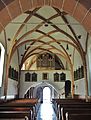
Interior view towards the gallery


The municipality has numerous cultural, sports and other associations, the most famous being the Slovenian cultural association Bilka . Two internationally known artists come from Ludmannsdorf: the writer Janko Ferk and the painter Meina Schellander .
The Land Art project created by “Kunstbau Saager” under the title “Drau-Art” is a landscape design by the three artists Edmund Hoke , Tomas Hoke and Armin Guerino . With the water forms snail, whirlpool and roller, the three designers formed the bay near Selkach created by the Drau river. Nature, art and technology became a growing unit that is available to visitors. On the hill “ Ziggurat ”, on the wave chain and in the vortex-shaped harbor basin, new perspectives are offered to get closer to the Drava and the mountains.
There are numerous wayside crosses and wayside shrines in the municipality. This massive wayside shrine from the 16th century with shallow arched niches under its pyramid shingle roof is right near the reservoir bridge to Maria Elend in the small village of Selkach . The painting dates from the first half of the 19th century.
Economy and Infrastructure
The economic life of the community is mainly characterized by the timber industry; Six carpentry businesses, two carpentry shops and three sawmills are located in Ludmannsdorf. Holzbau Gasser GmbH is the largest employer in the municipality and therefore in the region.
politics
City council and mayor
The municipal council of Ludmannsdorf has 15 members and has been composed as follows since the municipal council election in 2015 :
The directly elected mayor has been Manfred Maierhofer (GL) since 2009.
coat of arms
In the Ludmannsdorf coat of arms, the traditional economic characteristics of today's municipality are expressed. The two golden tooth flanks symbolize saw blades and thus the extraction and processing of wood, the wickerwork in between is reminiscent of the basket weaving and straw processing, which is no longer in operation today. a. to straw hats, which used to be of regional importance as a home industry. The blue background alludes to the location of the municipality between Drau, Keutschacher Seental and Wörthersee.
The municipality's coat of arms and flag were awarded on March 5, 2002. The flag is yellow-blue with an incorporated coat of arms. The official blazon reads: "In blue with golden tooth flanks a golden, black-drawn basket weave in piles."
Personalities
Honorary citizen
- 2018: Franz Gasser (* 1927), entrepreneur
- 2018: Stefanie Quantschnig (* 1947), former mayor of Ludmannsdorf
- 2018: Meina Schellander (* 1946), object artist and painter
Sons and daughters of the church
- Ana Blatnik (* 1957), politician ( SPÖ ) and teacher
- Olga Voglauer (* 1980), politician (Greens)
literature
- Dekanalamt Ferlach (ed.) / Dekanijski urad Borovlje (izd.): Deanery Ferlach, past and present = Dekanija Borovlje, zgodovina in sedanjost . Klagenfurt / Celovec 2012, pp. 127–156.
- Anton Kreuzer: Köttmannsdorf and the surrounding area - the area between the Keutschacher Seental and the Draufluss . Kreuzer Buch, Klagenfurt 2011
- J. Filipič: The national differentiation process in the municipalities of Oberdörfl / Zgornja Vesca, Ludmannsdorf / Bilčovs and Köttmannsdorf / Kotmara vas in the years 1880 to 1945 . Vienna 1994.
- Polona Sketelj: Bilčovske družinske jaslice . Bilčovs 1996.
Web links
- Ludmannsdorf municipality (German / Slovenian)
- 20416 - Ludmannsdorf. Community data, Statistics Austria .
Individual evidence
- ↑ Statistics Austria: Population on January 1st, 2020 by locality (area status on January 1st, 2020) , ( CSV )
- ↑ http://www.kath-kirche-kaernten.at/pfarren/pfarre/C2965
- ↑ List of parishes in the dean's office in Ferlach / Borovlje
- ↑ Johann Scheinigg: Obraz rožanskega narečja na Koroškem . XXXII. Program of the kk state high school in Klagenfurt. Klagenfurt, printed by the St. Hermagoras printing house in 1882
- ^ Fran Ramovš: Kratka zgodovina slovenskega jezika . Ljubljana 1936.
- ↑ Tine Logar: Slovenska narečja . Ljubljana 1975
- ^ Tine Logar: Koroška slovenska narečja In: Enciklopedija Slovenije 5 (Kari – Krei), Ljubljana 1991.
- ^ Quoted from Wilhelm Deuer: The Carinthian municipal coat of arms . Verlag des Kärntner Landesarchiv, Klagenfurt 2006, ISBN 3-900531-64-1 , p. 174
Ebenthal | Feistritz im Rosental | Ferlach | Grafenstein | Keutschach am See | Köttmannsdorf | Krumpendorf | Ludmannsdorf | Magdalensberg | Maria Rain | Maria Hall | Maria Wörth | Moosburg | Poggersdorf | Pörtschach am Wörther See | Sankt Margareten im Rosental | Schiefling am Wörthersee | Techelsberg | Cell