
Maria Rain (Carinthia)
|
Maria Rain
|
||
|---|---|---|
| coat of arms | Austria map | |
 |
|
|
| Basic data | ||
| Country: | Austria | |
| State : | Carinthia | |
| Political District : | Klagenfurt-Land | |
| License plate : | KL | |
| Surface: | 25.52 km² | |
| Coordinates : | 46 ° 33 ' N , 14 ° 18' E | |
| Height : | 552 m above sea level A. | |
| Residents : | 2,561 (Jan 1, 2020) | |
| Population density : | 100 inhabitants per km² | |
| Postal code : | 9161 | |
| Area code : | 04227 | |
| Community code : | 2 04 17 | |
| NUTS region | AT211 | |
| Address of the municipal administration: |
Kirchenstrasse 1 9161 Maria Rain |
|
| Website: | ||
| politics | ||
| Mayor : | Franz Ragger ( SPÖ ) | |
|
Municipal Council : ( 2015 ) (19 members) |
||
| Location of Maria Rain in the Klagenfurt-Land district | ||
  |
||
| Source: Municipal data from Statistics Austria | ||


Maria Rain ( Slov .: Žihpolje from the outdated German name Seigbichl ) is a municipality with 2561 inhabitants (as of January 1, 2020) in the Klagenfurt-Land district in Carinthia .
geography
Maria Rain is located in the Rosental , eight kilometers south of Klagenfurt between the slopes of the Sattnitz massif and the Drau , which is dammed up here to form the Ferlach reservoir .
Community structure
The municipal area with the three cadastral communities Maria Rain ( Žihpolje ), Göltschach ( Golšovo ) and Toppelsdorf ( Dolča vas ) comprises the following 17 localities (population as of January 1, 2020):
- Angern ( Ingarje ) (45)
- Angersbichl ( Gargorica ) (173)
- Ehrensdorf ( Vršta vas ) (115)
- Göltschach ( Golšovo ) (247)
- Haimach ( Imov ) (41)
- Maria Rain ( Žihpolje ) (1004)
- Nadram ( Nadrom ) (25)
- Oberguntschach ( Zgornje Humče ) (22)
- Obertöllern ( Zgornje Dole ) (15)
- Saberda ( Zabrda ) (32)
- Ortisei ( Šenturh ) (150)
- Stemeritsch ( Smeriče ) (26)
- Strantschitschach ( Strančiče ) (33)
- Toppelsdorf ( Dolča vas ) (122)
- Tschedram ( Ščedem ) (305)
- Unterguntschach ( Spodnje Humče ) (19)
- Untertöllern ( Spodnje Dole ) (187)
history
A document in which a church "Maria ad Dravum" (Maria an der Drau) built by a Salzburg bishop is mentioned dates from the year 927. The current name of the place was first mentioned in 1313.
The community area belonged to the Hollenburg district court until 1848 . An important landlord was the Cistercian monastery Viktring , which also staged the Marian pilgrimage and looked after the local church until its abolition in 1786. The double-towered church, originally built in the late Gothic style, is the landmark of the pilgrimage site Maria Rain, the late Gothic building, which was built in the 15th century, was expanded in the Baroque style by Viktring abbots between 1700 and 1729. It was named after today's community and was also shown on an earlier 20 shilling banknote.
In 1850 the three cadastral communities Toppelsdorf, Tschedram and Göltschach formed what is today the local community, which was initially named after the largest town, Toppelsdorf. In 1895 it was renamed Maria Rain due to the increased popularity of the church village, which is also valued as a summer resort .
On a hill (in the immediate vicinity of the pilgrimage church) with a view towards the southwest, the so-called Kaiserhütte was built in 1907 as a shelter for Emperor Franz Joseph I , who observed the maneuvers of his army in the Rosental from here .
A view of Maria Rain can be seen on the reverse of the 20 Schilling banknote from 1956.
population
According to the 2001 census, the community of Maria Rain has 2,020 inhabitants, 96.1% of whom are Austrian citizens. According to their own information, 3.9% belong to the Slovene-speaking ethnic group .
76.6% of the community population profess to the Roman Catholic Church , 5.0% to the Evangelical Church and 1.1% to Islam . 12.8% are without religious beliefs.
Economy and Infrastructure
Until the 20th century, the rural character of the municipality dominated the economic and working life, in the last few decades Maria Rain has developed into a preferred place of residence for people commuting to the nearby state capital.
Agriculture and timber are traditionally practiced in the community, and tourism has also played an important role since the 20th century.
The Loiblpass Straße (B 91 / Europastraße E652) leads through the municipality when coming from Klagenfurt in the direction of the Loibltunnel. Slovenia , Ferlach and Klagenfurt can be reached from Maria Rain within half an hour.
A state road connects the community over the Sattnitz ridge with Ebenthal in Carinthia .
Maria Rain is also on the ÖBB branch line from Klagenfurt to Rosenbach and has its own train station.
Up until its demolition on September 15, 2011, the Pfaffenwald transmission mast , which was used to broadcast television programs , was located in the village of Strantschitschach .
Culture and sights
Parish church Maria Rain
The double-towered parish church of Maria Rain is the third largest church in Carinthia. The building received its current form of a baroque church through a renovation in 1729, but documented predecessor buildings already existed in the 9th and 10th centuries.
Kaiserhütte
In honor of Franz Josef I , Emperor of Austria-Hungary from 1848 to 1916, this wooden structure was built at the highest point of the village with a wonderful view of the Rosental and the Karawanken mountains behind . The occasion was his visit to the site, when he in 1907 in maneuvers of the Austrian kuk watched army.
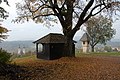
Alte Kaiserhütte - until 2009

New Kaiserhütte - since 2009

View from the Kaiserhütte in winter - over the Rosental to the Karawanken, in the middle of the Mittagskogel


.jpg)
Hemmafelsen
The Hemmafelsen is located on the municipal road from Haimach to Guntschach, directly on the southern edge of the Sattnitz ridge to the Rosental. Hemma von Gurk is said to have stopped at this point when she was traveling to her properties in Lower Styria and was waiting for the ferry to cross the Drau .
Farm museum in Saberda
The part-time farmer Johann Lutschounig, who died in the spring of 2010, collected long-forgotten tools and other utensils and created a special kind of museum on his farm in Saberda. Thousands of farm tools and work aids adorn his courtyard building, the threshing floor and are practically visible all over the courtyard.
How quickly the past can be forgotten, Lutschounig explained using the example of the "Strumpfla". In the middle of the 20th century, butter and cream were still produced in these wooden containers, today hardly anyone knows what to do with the word. And so that these witnesses of the past are not finally forgotten, Lutschounig exhibited the devices and weapons in his museum in Saberda.
Guntschacher Au
The Guntschacher Au lies between the two districts of Unter- and Oberguntschach in the municipality of Maria Rain on the left bank of the Drau. The formation of the floodplain can be traced back to hydraulic engineering measures in the 1970s and the construction of the Annabrücke barrage in 1981. The Au is about 20 to 25 meters lower than Unter- and Oberguntschach.
The Guntschacher Au is not only the first protected area in 13 years, but also the first to be designated with new protected area signs. The special thing about the new nature reserve is a time-limited entry ban from January 1st to July 31st each year.
Sattnitz Ridge and Eternal Rain Natural Monument
The Sattnitz ridge stretches in an east-west direction south of the Wörthersee and the Klagenfurt field and north of the Rosental , from the Rauniak estate ( Grafenstein municipality ) in the east to Velden in the west.
The largest part consists of the plate of the Sattnitz conglomerate, which is up to several hundred meters thick. The typical appearance of the steep walls or the partly overhanging conglomerate rocks are the so-called balms (= hollows). The south-facing slopes sloping down towards the Drau in the eastern part of the Sattnitz between the village of Maria Rain and the Annabrücke have mainly orchid-rich beech forests and mixed deciduous forests on the debris-rich slopes.
By the exit of numerous seepage considerable Kalktuffbildungen and Rieselfluren are partially emerged, such as the the natural monument declared Eternal Rain in Maria Rain.
politics
Municipal council
The municipal council has 19 members and has been composed as follows since the last municipal council election in 2015 :
The directly elected mayor has been Franz Ragger (SPÖ) since 2009.
coat of arms
In Maria Rain's coat of arms, the M, formed as a silver double rafter, alludes on the one hand to the parish name or the parish patroness, but also to the distinctive double tower of the church. The floating crown is a symbol of the pilgrimage to the Mother of God and Queen of Heaven. The pair of ears stands for agriculture and arable farming on the southern slopes of the Sattnitz.
The official blazon reads: "In red an M formed from a lowered silver double rafter, underlaid by two intersecting silver ears inclined outwards under the head of the shield, overlaid by a silver crown."
The coat of arms and flag were awarded to the municipality on March 17, 1987, the flag is red and white with an incorporated coat of arms.
Personalities
- In 1863 Josef Lutschounig was born in Untertöllern . As an Austro-Hungarian officer he was awarded the Military Maria Theresa Order in World War I and was raised to the nobility as Freiherr Lutschounig von Felsenhof . The Villach Lutschounig barracks is named after him. He was the brother of the Reichsrat member and mayor of Maria Rain, Jakob Lutschounig .
literature
- Hannes Kastrun: Maria Rain - Through the ages . Self-published by the author, ISBN 3-9501362-1-5
Web links
- www.maria-rain.gv.at Community portal
- 20417 - Maria Rain (Carinthia). Community data, Statistics Austria .
Individual evidence
- ↑ Statistics Austria: Population on January 1st, 2020 by locality (area status on January 1st, 2020) , ( CSV )
- ^ Office of the Carinthian provincial government, municipal council election 2015
- ^ Office of the Carinthian Provincial Government, Mayoral election 2015
- ^ Wilhelm Deuer: The Carinthian community arms . Verlag des Kärntner Landesarchiv, Klagenfurt 2006, ISBN 3-900531-64-1 , p. 184
Ebenthal | Feistritz im Rosental | Ferlach | Grafenstein | Keutschach am See | Köttmannsdorf | Krumpendorf | Ludmannsdorf | Magdalensberg | Maria Rain | Maria Hall | Maria Wörth | Moosburg | Poggersdorf | Pörtschach am Wörther See | Sankt Margareten im Rosental | Schiefling am Wörthersee | Techelsberg | Cell