
Pack (Hirschegg-Pack municipality)
|
Pack ( Former Parish ) locality  Cadastral Parish Pack |
|||
|---|---|---|---|
|
|||
| Basic data | |||
| Pole. District , state | Voitsberg (VO), Styria | ||
| Judicial district | Voitsberg | ||
| Pole. local community | Hirschegg pack | ||
| Coordinates | 46 ° 58 '38 " N , 14 ° 59' 5" E | ||
| height | 1116 m above sea level A. | ||
| Residents of the village | 406 (January 1, 2020) | ||
| Building status | 358 (April 1, 2020 ) | ||
| Area d. KG | 3,906.18 ha (Dec. 31, 2019) | ||
| Postcodes | 8583, 8584, 9451 Hirschegg-Pack | ||
| prefix | + 43/3146 (Modriach) | ||
| Statistical identification | |||
| Locality code | 16193 | ||
| Cadastral parish number | 63348 | ||
| Counting district / district | Pack (61629 002) | ||
 Location of the former municipality of Pack in the Voitsberg district (as of 2014) |
|||
| Independent municipality until the end of 2014 Source: STAT : Local directory ; BEV : GEONAM ; GIS-Stmk |
|||

Pack is a former municipality and village with 406 inhabitants (as of January 1, 2020) in the judicial district or district of Voitsberg in Styria in Austria . As part of the municipal structural reform in Styria , Pack has been merged with the Hirschegg municipality since 2015 ; the new municipality is called Hirschegg-Pack . The basis for this is the Styrian Municipal Structural Reform Act - StGsrG.
geography
The village of Pack is located at the Packsattel west of Graz , on the border between Styria and Carinthia . The municipality is located in the Packalpe in the north of the Koralpe . There are some small sites of tourmaline , epidote , beryl , titanite , zirconium , cassiterite and spodumene .
Pack includes only one cadastral parish that bears the same name. Your main route is the Packer Straße . The Pack section of the A 2 southern motorway passes under the community in the approximately two-kilometer-long Kalcherkogel tunnel, at the southern portal of which the Pack motorway exit leads to the community area and Packer Strasse.
The neighboring communities of Pack are Edelschrott and Modriach in the east, Kloster in the south, Preitenegg in the west and Hirschegg in the north .
The Hebalm with the ski area of the same name is located in the Packwinkel district in the south of the municipality .
The community is located on the Packer Bach, which rises at the Hebalm and flows into the Teigitsch at the Stampf . Before that, the Packer reservoir lies on the Packer Bach, which is also called the reservoir stream (at the confluence of the Modriach Bach). A popular recreational area has developed around this reservoir.
Pack is located on the north-south long-distance hiking trail and on the European long-distance hiking trail E6 .
history
The name is derived from the Slovene paka "hill, hill", also the name for the watershed (Slovene paka voda "the reversed, to the other side flowing water"). Another interpretation relates to the fact that there was a border at the Packsattel, where goods had to be reloaded and repacked (a similar derivation is documented for the “Heb-” alms of the Styrian peripheral mountains, where goods had to be moved between different transport vehicles). An older name for the area "Vier Thöre" is derived from a street crossing, the connections of which were closed with four gates.
In the 15th and 16th centuries, after the quarter division of Styria in 1462 , Pack was initially in the area of Upper Styria in the "Viertel enhalb der Piberalm" and there in the Judenburg quarter. The Kainach Valley as far as Ligist and Lieboch , Übelbach and Thal to the west of Graz also belonged to this quarter . In 1677, the Kainach Valley and its surroundings, including the Pack area, were detached from the Judenburg district and moved to the "Quarter between Mur and Traa" (Drau), the predecessor of the Marburg district , where it was initially also after the regional reforms remained under Maria Theresa and Joseph II . From November 1, 1783, the Kainachtal came from the Marburger Kreis to the Grazer Kreis .
On May 6, 1543, Philipp Renner consecrated as coadjutor of Lavant Bishop Leonhard Peurl “ad eccl. parrochialem in the packh “a bell. As suffragan bishops of the Salzburg archbishop, the bishops of Lavant had the right to ordain in the areas belonging to the archbishopric of Salzburg , even if the respective parish did not belong to their diocese (Pack was already part of the diocese of Seckau at that time ).
In the 16th and 17th centuries, the municipal area belonged to the “ Burgfried der Ämter Pack, Hirscheck and Modriach” for the lower jurisdiction and to the regional court of Voitsberg-Greißenegg of the Obervoitsberg estate for the higher (blood) jurisdiction . However, this only applied outside the eaves : within it, the full lower jurisdiction lay with the respective landlord in the 16th century. Even then, the Pack was considered an important transition, which is documented by its inclusion in the work “Topographia Ducatus Stiriae, Graz 1681” by Georg Matthäus Vischer .
From 1770, when people and houses were recorded for the first time in Austria , people, migrating cattle and houses from Pack are recorded independently. This registration took place within the framework of the army reforms under Maria Theresa and Joseph II . It led to the introduction of the " numbering sections " (also called Konskriptionsgemeinden ). Pack was one such section. Together with the numbering section Modriach , Pack belonged to the western part of the Ligist advertising district . In the years that followed, the numbering section became the tax municipality and cadastral municipality of the same name Pack.
The community emerged from the cadastral community in 1850 without changing its territory.
Culture and sights
Personalities
Honorary citizen
- 1982 Josef Krainer (1930–2016), governor
Sons and daughters of the former parish
- Andreas Münzer (1964–1996), bodybuilder
Historical maps
- The pack in historical representations

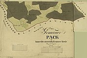
The pack in the 17th century in the "Topographia Ducatus Stiriae" by Georg Matthäus Vischer

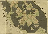
The municipality (far left) around 1789 ( Josephinische Landesaufnahme )

The western border of Pack at the "four gates" around 1789 (far right)

The pack around 1835, Franziszeische Landesaufnahme
Stocker Alm / Hebalm (around 1823, Franziszeischer Cadastre )
Packwinkel , Steinbauer (around 1823, Franziszeischer Cadastre, Hackerkogel = Klementkogel )
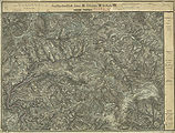
Hebalm area 1877/78, recording sheet of the francisco-josephine (3rd) land survey

Special map of the francisco-josephine land survey, depiction 1894, partially corrected until 28th XI. 1913


Web links
- 61616 - Pack (Hirschegg-Pack municipality). Community data, Statistics Austria .
Individual evidence
- ↑ Statistics Austria: Population on January 1st, 2020 by locality (area status on January 1st, 2020) , ( CSV )
- ^ Styrian municipal structural reform .
- ↑ Section 3, Paragraph 10, Item 1 of the Act of December 17, 2013 on the reorganization of the municipalities of the State of Styria ( Styrian Municipal Reform Act - StGsrG). Provincial Law Gazette for Styria of April 2, 2014, No. 31, year 2014, ZDB -ID 705127-x , p. 4.
- ↑ Leopold Weber (Ed.): “Handbook of the deposits of ores, industrial minerals and energy resources of Austria. Explanations of the metallogenetic map of Austria 1: 500,000 including the industrial minerals and energy resources. “Archive for deposit research, Volume 19, Vienna 1997, Geologische Bundesanstalt, ISBN 3-900312-98-2 , ISSN 0253-097X , p. 317. ( PDF , 43 MB)
- ↑ Mountain name directory
- ^ Gerhard Artl, Gerhard H. Gürtlich, Hubert Zenz: "Coal and Railway. 150 years Graz-Köflacher-Eisenbahn. “Verlag Fassbaender, Vienna 2010, ISBN 978-3-902575-38-8 , p. 47.
- ^ Oskar Veselsky: "The consecration reports from the ordination and consecration protocols of the bishops of Lavant in the 16th century." In: Sources for the historical regional studies of Styria, published by the Historical Commission for Styria - HLK, XI. Volume, Graz 1997, self-published by HLK, without ISBN, p. 110.
- ^ Anton Mell: "High and lower criminal jurisdictions. Regional courts and truce in Styria. ”In: Anton Mell, Hans Pirchegger: “ Styrian court descriptions ” . As sources for the Historical Atlas of the Austrian Alpine Countries, Section I, Regional Court Map: Styria, In the series: “Sources for the constitutional and administrative history of Styria”, Volume I. Published by the Historical Commission for Styria, Graz 1914, general: pp. XX – XLIV. On the keep: p. 229 .
- ^ Mell: "Criminal Jurisdictions", page XXVI.
- ↑ Manfred Straka: "Administrative boundaries and population development in Styria 1770-1850. Explanations for the first delivery of the Historical Atlas of Styria. “Research on the historical regional studies of Styria, XXXI. Tape. Published by the Historical Commission for Styria - HLK, self-published by the HLK, Graz 1978, p. 207.
- ↑ Manfred Straka: "Numbering sections and advertising districts of Styria 1779/81." Maps on a scale of 1: 300,000. In: "Historischer Atlas der Steiermark." Published by the Historical Commission for Styria - HLK, Academic Printing and Publishing Company, Graz 1977, 1st delivery: "Administrative borders and population development in Styria 1770-1850." Sheet 2 (North sheet) .
- ↑ Manfred Straka: “Tax communities and advertising districts of Styria 1798–1810.” Maps on a scale of 1: 300,000. In: "Historischer Atlas der Steiermark." Published by the Historical Commission for Styria - HLK, Academic Printing and Publishing Company, Graz 1977, 1st delivery: "Administrative boundaries and population development in Styria 1770-1850." Sheet 4 (North sheet)
- ↑ Manfred Straka: “cadastral communities and advertising districts of Styria 1818–1848.” Maps on a scale of 1: 300,000. In: "Historischer Atlas der Steiermark." Published by the Historical Commission for Styria - HLK, Academic Printing and Publishing House, Graz 1977, 1st delivery: "Administrative borders and population development in Styria 1770-1850." Sheet 6 (North sheet) .

Cadastral communities: Hirschegg-Piber | Hirschegg-Rein | pack
Localities Hirschegg-Piber-Sonnseite | Hirschegg-Piber-Winkel | Hirschegg-Rein | Pack • Villages: Hirschegg-Piber-Dorf | Hirschegg-Rein | pack
Scattered houses: amber | Dörfl | Hebalm | Hirschegg-Piber-Sonnseite | Hirschegg-Piber-Winkel | Hirschegg-Rein-Winkel | Mitterberg | Mitteregg | Oberrohrbach | Packing angle downside | Packwinkel-Sonnseite | Riegl | Steinberg | Unterrohrbach
Almen Amber Hut | Brandnerhütte | Fur hut | Großebenhütte | Grünhütte | Acid hut | Blacksmith's hut
Other locations: Refuge Barbarahaus | Blasi | Ebner | Refuge Emil-Stöhr-Hütte | Gasthaus Fichtenhof | Fisherman | Franzbauer | Refuge Franzlhütte | Fuchsjörgl | Geidl | Gerhaber | Trench builders | Grantner (at the Hebalm) | Weekend house Grantner (near Unterrohrbach) | Gressenberger | Großofner | Hacker | Hansbauer | Hochgößler | Hochkiedl | Hofbauer | Hütter | Kiel | Kleinofner | Kochbauer | Corri | Krick | Laughter | Lip builder | Gasthaus Moasterboden | Münzer | Upper Schröck | Oberländer | Ofnerhans | Ofnerhiasl | Pauljodl | Paxbauer | Peterbauer | Gasthaus Pongratzwirt | Pöschl | Hunting lodge Pöschlhütte | Hunting lodge Rainerwaldhütte | Rieger | Rinzbauer | Ritz (at Packwinkel-Sonnseite) | Rudres | St. Bartholomew Chapel | Schaller | Sheikh | Grinder | Blacksmith's yodel | Schmolli | Schriebl | Rubble | His | Sorger | Sorger | Sorgerchristi | Spenger | Gasthaus Spengerwirt | Gasthaus Steinbauer | Weekend house Stering | Ullibauer | Veitbauer | Wendelbauer | Wipfler | Zenzbauer
Counting district: Hirschegg-Piber | Hirschegg-Rein | pack