
Sausal (region)
| Sausal | |
|---|---|
 Kitzeck from the southwest |
|
| Highest peak | Demmerkogel ( 671 m above sea level ) |
| location | Styria , Austria |
| part of | Southeastern Alpine Foreland |
| Classification according to | Landscape structure of Styria V.2 |
| Coordinates | 46 ° 48 ' N , 15 ° 27' E |
| Type | Hill country |
| rock | Phyllitic slate |
| Age of the rock | Paleozoic |
The or the Sausal in Styria describes the hilly country between the rivers Sulm and Laßnitz . The highest point is the Demmerkogel ( 671 m above sea level ), on which there is a lookout tower.
Surname
The name "Sausal" is mentioned in documents from the Middle Ages as "Susil". It is derived from the Latin "Solva silva" (Sulmwald). Only in an older publication is the opinion published that the name derives from “Sau suhle ” because of the abundance of wild boars in the area .
geography
It is made of Paleozoic slate and part of the Central Styrian threshold (Sausal threshold), which separates the East Styrian from the West Styrian basin .
Wine , chestnut and fruit cultures can be found in Sausal , and pumpkin cultivation also plays a role - the typical Styrian pumpkin seed oil is obtained from them.
The main towns in the area are Sankt Nikolai im Sausal in the north, Sankt Andrä-Höch in the west and Kitzeck im Sausal in the south . Popular lookout points are on the Demmerkogel in the center and on the Kreuzkogel in the east of the region.
The Klapotetz is a cultural characteristic of the area .
Historical maps of the Sausal

Lower reaches of Laßnitz and Sulm , Leibnitz in the Josephinische Landesaufnahme approx. 1780

The valley of Schwanberg west of the Sausal
Wildon and Leibnitz, Franzisko-Josephinische Landesaufnahme approx. 1895, additions up to 1914

In the west of the Sausal: Deutschlandsberg and Schwanberg

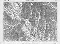
Location of Sausal in the general map of Central Europe , sheet 33 ° 47 ° Graz , status 1893


literature
- Paul Anton Keller : The Sausal Year , Leykam-Verlag, Graz, 1942.
Web links
- General history and cultural landscape of Sausal , script, 1845, Georg Mally, kk professor
Individual evidence
- ↑ Chronicle of the community of Kitzeck im Sausal (accessed June 4, 2012).
- ^ Robert Baravalle: The Deutschlandsberg castle. Graz writing and office calendar 1932 for family and office. 148th year. Verlag Leykam Graz 1932. p. 226.