
Lavamünd
|
market community Lavamünd
|
||
|---|---|---|
| coat of arms | Austria map | |
 |
|
|
| Basic data | ||
| Country: | Austria | |
| State : | Carinthia | |
| Political District : | Wolfsberg | |
| License plate : | WHERE | |
| Surface: | 93.7 km² | |
| Coordinates : | 46 ° 39 ′ N , 14 ° 57 ′ E | |
| Height : | 348 m above sea level A. | |
| Residents : | 2,870 (January 1, 2020) | |
| Population density : | 31 inhabitants per km² | |
| Postal code : | 9473 | |
| Area code : | 0 43 56 | |
| Community code : | 2 09 09 | |
| NUTS region | AT213 | |
| Address of the municipal administration: |
Lavamünd 65 9473 Lavamünd |
|
| Website: | ||
| politics | ||
| Mayor : | Josef Ruthardt ( SPÖ ) | |
|
Municipal Council : ( 2015 ) (23 members) |
||
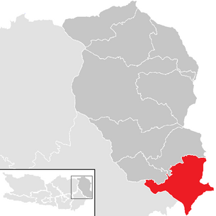
| Location of Lavamünd in the Wolfsberg district | ||
  |
||
| Source: Municipal data from Statistics Austria | ||

Lavamünd ( Slov. Labot ) is a market town with 2870 inhabitants (as of January 1, 2020) in the Wolfsberg district in Carinthia .
geography
Lavamünd is located in the south-east of Carinthia on a headland at the confluence of the Lavant and the Drau , which also forms the southern boundary of the municipality. The height is 348 m above sea level, making Lavamünd the lowest point in Carinthia. In order to protect Lavamünd from a hundred-year flood, the construction of a 1.5 km long protective wall began on October 16, 2018, and two new bridges will be built over the Lavant, so that there should be no more blockages. The flood protection should be completed by 2023.
Community structure
Lavamünd is divided into ten cadastral communities , Slovenian names are given in brackets (see also Carinthian Slovenes ):
- Ettendorf
- Großlamprechtsberg
- Hart (Dobrova)
- Lamprechtsberg-Hartneidstein
- Lavamünd (Labot)
- Lorenzenberg (Šentlovrenc)
- Magdalensberg
- Rabenstein (Rabštajn pri Labotu)
- Weissenberg
- Miracles (Drumlje pri Labotu)
The municipality includes the following 20 localities (the number of inhabitants as of January 1, 2020 in brackets):
- Achalm (165)
- Ettendorf (301)
- Hart / Dobrova (143)
- Krottendorf (140)
- Lamprechtsberg (182)
- Lavamünd / Labot (320)
- Lorenzenberg / Šentlovrenc (70)
- Magdalensberg / Štalenska gora (440)
- Parish Village (305)
- Pleststätten (87)
- Rabenstein / Rabštajn (29)
- Rabensteingreuth (85)
- Schwarzenbach (110)
- St. Vincent (6)
- Unterbergen (74)
- Undergrowth (54)
- Weissenberg (198)
- Witternig (21)
- Places of Wonders / Drumlje (92)
- Line (48)
Neighboring communities
| St. Paul in the Lavant Valley | St. Georgen in the Lavant Valley | |
| Ruden |
.svg)
|
Eibiswald |
| Neuhaus | Dravograd | Dravograd |
history

The community area near the Elbitz, an area east of the mouth of the Lavant into the Drau , was already settled in Roman times, as finds from graves and coins show, so that the oldest settlement in today's Lavamünd was established here. A tomb of a Roman stone grave, which today stands in front of the Gasthaus zum Adler, bears witness to this time.
In 1091, Count Engelbert von Spanheim gave the St. Paul Monastery, which he had founded, a Stadelhof zu Lavamünd. A street market developed at the foot of the castle by the 14th century, which gained importance due to its location at the meeting of Lavant and Drava. The foundation of the Lavamünd market is presumed to have been in 1240, the first written mention of the place comes from the year 1334. In 1461 Emperor Friedrich III. the blood judiciary market .
The village was hit by floods from the Drava several times , in 1851 even the main square was flooded.
The community, founded in 1850, was expanded in 1921 to include the parts of the community of Kienberg that did not fall to Yugoslavia (cadastral communities Lorenzenberg and Rabenstein) and in 1958 and 1973 to include parts of the dissolved communities of Legerbuch and Ettendorf .
With the construction of the Lavant Valley Railway in 1878, Lavamünd was made accessible by the railway. In 1879 the first train went from Wolfsberg to Unterdrauburg (today's Dravograd ) via Lavamünd. After the First World War, the Unterdrauburg railway junction fell to what was then the SHS state. The corridor traffic was operated by the 1965th With the construction of the Jauntalbahn , an inland connection from Wolfsberg to Klagenfurt was created again, but the Jauntalbahn branches off from the Lavanttalbahn at St. Paul in Lavanttal. So Lavamünd was on a dead track to Yugoslavia. The section Lavamünd - Unterdrauburg was removed after the opening of the Jauntalbahn.
The language border ran at Lavamünd at least until the 19th century.
After the First World War , on December 3, 1918 , Yugoslav troops marched into Lavamünd and St. Paul via Unterdrauburg and threatened to penetrate further into the Lavant Valley. In the course of the Carinthian defensive battle , Lavamünd was liberated before the end of the year. An armistice followed, which was broken on April 29, 1919 by a renewed Yugoslav offensive. As a result, Lavamünd was occupied again by Yugoslavia until the Carinthian referendum on October 10, 1920. In the referendum, the demarcation line ran directly through the municipality. In the vote, 92.9% of the community in Lavamünd voted for Austria. Since this was the second best result for Austria, the motif of the municipal coat of arms was changed from a bowl with Johannishaupt to a stylized ballot box in 1959.
Population development

From 1991 to 2001 Lavamünd had a positive birth balance (+121), but a negative migration balance (-391). In the following 10 years there were already 24 deaths more than births and 400 more people moved away from the community than immigrated.
At the time of the 2001 census, the market town of Lavamünd had 3,548 inhabitants, 97.9% of whom were Austrian citizens. 98.2% gave German, 0.3% Slovenian and 0.7% Croatian as the colloquial language. 96.8% committed themselves to the Roman Catholic Church, 0.5% to the Evangelical Church and 0.4% to Islam. 1.7% of the population was without religious belief.
Culture and sights


- Catholic parish church Lavamünd Maria Himmelfahrt
- Catholic market church Lavamünd hl. John the Baptist
- Lavamünd Calvary Church
- Catholic parish church Ettendorf hl. Markus
- Catholic parish church Lorenzenberg ob Lavamünd hl. Laurentius
Economy and Infrastructure
Major parts of the Lavamünd power plant (a run-of- river power plant on the Drau) and the Koralpe power plant , a pumped storage power plant, are located in Lavamünd .
traffic
- Road: In the municipality, the B80 , which was considered a side branch of the guest worker route , crosses with the B69 , which leads over the Soboth .
- Railway: Lavamünd is located on the Lavant Valley Railway, which is no longer in operation here .
- Hiking trails: The Südalpenweg , an Austrian long-distance hiking trail, runs through Lavamünd . Furthermore, the Jakobsweg West Styria joins the South Austrian Jakobsweg , which follows the course of the Drau.
politics
The municipal council consists of 23 members. Since the municipal council elections in 2015 , it has been composed as follows:
mayor
The directly elected mayor is Josef Ruthardt (SPÖ).
coat of arms
The Lavamünd market has had a market coat of arms since the 17th century. H. the severed head of John on a dish, showed. After the community felt that the drastic depiction was no longer up-to-date, the decision was made in 1959 for a new municipal coat of arms. It was decided to use a stylized representation of the referendum of 1920 : A ballot box in confused colors with a green ballot (as a commitment for Austria, the ballot for Yugoslavia was white) reminds that the community with 96.9% went to Pustritz during the plebiscite (now part of the municipality of Griffen ) brought the best result for Austria. The silver wavy lines for the Lavant and Drau rivers stand in the base of the shield.
The official blazon of the municipal coat of arms reads: “A shield divided by a silver line, the lower blue field of which is divided by two silver wavy lines. In the upper field, split by gold and blue, an urn in alternating colors, resting on the dividing line, growing out of the column line, from which the upper part of a slanted green ballot protrudes. "
The coat of arms and flag were awarded to the community on March 1, 1963. The flag is blue and yellow with an incorporated coat of arms.
Personalities
Sons and daughters of the church
- Herbert Pansi (1920–1988), politician of the SPÖ , member of the Federal Council 1963–1964, member of the National Council 1964–1979, third President of the National Council 1979
- Hubert Urach (* 1945), musician and composer
- Anton Pistotnig (* 1949), musician and military bandmaster of Lower Austria (1980–2011)
- Josef Pachler (* 1950), boxer
- Peter Stauber (* 1953), politician of the SPÖ , member of the National Council 2006–2013, mayor of St. Andrä im Lavanttal since 1997
Historical maps

Lavamünd at the confluence of the Lavant and Drau rivers in the recording sheet of the land survey 1877/78

Unterdrauburg is the next larger town south of Lavamünd

Geology of the Lavamünd area


Web links
- Market town of Lavamünd
- 20909 - Lavamünd. Community data, Statistics Austria .
Individual evidence
- ↑ million for flood protection on ORF-Kärnten from October 16, 2018, accessed on October 17, 2018
- ↑ Statistics Austria: Population on January 1st, 2020 by locality (area status on January 1st, 2020) , ( CSV )
- ↑ Michael Wedekind: National Socialist Occupation and Annexation Policy in Northern Italy 1943 to 1945. Oldenbourg Wissenschaftsverlag, Munich 2003, p. 18
- ^ Statistics Austria, A look into the community Lavamünd, population development. Retrieved February 14, 2019 .
- ↑ Office of the Carinthian Provincial Government ( Memento of the original from May 25, 2015 in the Internet Archive ) Info: The archive link was inserted automatically and has not yet been checked. Please check the original and archive link according to the instructions and then remove this notice.
- ^ Quoted from Wilhelm Deuer: The Carinthian municipal coat of arms . Verlag des Kärntner Landesarchiv, Klagenfurt 2006, ISBN 3-900531-64-1 , p. 166
Cities: Bad St. Leonhard im Lavanttal | Saint Andrew | Wolfsberg . Municipalities: Frantschach-Sankt Gertraud | Lavamünd | Preitenegg | Reichenfels | Sankt Georgen im Lavanttal | Sankt Paul im Lavanttal