Way of St. James West Styria
| Way of St. James West Styria | |
|---|---|
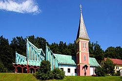
 Starting point in Thal near Graz: St. Jakob parish church |
|
| Data | |
| length | 153 km |
| location | West Styria |
| Starting point |
Thal 47 ° 4 ′ 34.4 " N , 15 ° 21 ′ 42.7" E |
| Target point |
Lavamünd 46 ° 38 '10.5 " N , 14 ° 57' 21.1" E |
| Type | Long-distance hiking trail |
| The highest point | Großer Speikkogel (2140 m above sea level) |
| Lowest point | 348 m above sea level A. |
| Level of difficulty | moderate |
| season | all year round |
| Months | April - October |
The Jakobsweg West Styria is a cross-federal state, approximately 153 kilometers long, signposted section of the southern Austrian Jakobsweg in the Austrian Jakobswegen network .
Starting from Thal near Graz , the pilgrimage route leads mainly on existing hiking and pilgrimage routes, partly on asphalt municipal and country roads through the landscape protection areas of the western mountain and hill country of Graz, Pleschkogel-Walzkogel-Pfaffenkogel, Pack - Reinischkogel - Rosenkogel , Koralpe and Soboth through western Styria . He crossed shortly after Sobother dam the border to Carinthia , via Lorenzenberg and Sankt Lorenzen to Lavamünd and ends there in the over Slovenia leading section of the southern Austrian Camino de Santiago.
The Way of St. James leads through the Styrian districts of Graz-Umgebung , Voitsberg and Deutschlandsberg as well as the Carinthian district of Wolfsberg .
Along the way are the Jakobskirchen parish church Thal near Graz , parish church Geistthal , parish church Freiland near Deutschlandsberg and parish church Soboth .
The pilgrimage route is divided into eight stages with a length between 14 and 26 kilometers, at the beginning of which as well as at each St. James' Church there is a pilgrim stone with details of the kilometers to be walked to Santiago de Compostela .
description
The Way of St. James through western Styria begins at the parish church Thal bei Graz and leads on the way to Sankt Pankrazen (locality Gschnaidt ) through the localities Plankenwarth and Sankt Oswald bei Plankenwarth . There is a Lourdes grotto in Stiwoll .
On the way to Bärnbach to the parish church of Sankt Barbara, which was redesigned by Friedensreich Hundertwasser in 1988, the Jakobskirche Geistthal is located at the northernmost point of the route and on the further route the parish of Kohlschwarz and the Sankt Andreas church in Piber .
Past the city of Köflach and the second largest Marian pilgrimage site in Styria, Maria Lankowitz , you reach Edelschrott . The Way of St. James runs past the Hirzmann reservoir to the Hoiswirt in Modriach . On the way to Osterwitz there is a Jakobskirche in Freiland near Deutschlandsberg .
Up to the Koralpenhaus you hike through the Weinebene and the next destination is the Jakobskirche Soboth . Past the Sobother reservoir, the pilgrimage route crosses the Styrian-Carinthian border and leads to Lavamünd .
Project
The association for the promotion of the Styrian Way of St. James was founded in 2009 and aims to enrich the South Austrian Way of St. James with the variant through West Styria.
The financing has so far been largely carried out without using public funds. Reinhold Waldhaus is the initiator and driving force behind the association. The project is supported by the Austrian Alpine Association and the Austrian Friends of Nature as well as the Lipizzaner Heimat Steiermark tourist association.
List of milestones
literature
- Peter Lindenthal : On the Way of St. James through South Austria, Slovenia and South Tyrol. From Graz via Marburg, Carinthia, East and South Tyrol to Innsbruck. Tyrolia, 2nd edition 2007, ISBN 3-7022-2438-6 .
- Reinhard Dippelreither : West Styrian Way of St. James. Outdoor manual, series: Der Weg ist das Ziel, Volume 316, Conrad Stein Verlag, Welver 2012, ISBN 978-3-86686-379-8 .
Web links
- www.jakobsweg-steiermark.at
- Way of St. James Austria
- Pilgrimage in Austria
- In the footsteps of pilgrims and pilgrims
- Video of the opening of the Way of St. James West Styria on July 25, 2010
Individual evidence
- ↑ Course of the eight stages of the Way of St. James in West Styria ( Memento of the original from January 9, 2011 in the Internet Archive ) Info: The archive link was automatically inserted and not yet checked. Please check the original and archive link according to the instructions and then remove this notice.