
Freiland Alm
| Freeland Alm (location component ) | |||
|---|---|---|---|
|
|||
| Basic data | |||
| Pole. District , state | Deutschlandsberg , Styria | ||
| Judicial district | Deutschlandsberg | ||
| Pole. local community | Deutschlandsberg ( KG Klosterwinkel ) | ||
| Locality | monastery | ||
| District | monastery | ||
| Coordinates | 46 ° 54 '47 " N , 15 ° 3' 2" E | ||
| height | 1416 m above sea level A. | ||
| Statistical identification | |||
| District | monastery | ||
 Freiländer Alm (hut at the back); in front the Rehbockhütte on Hebalmstraße |
|||
| Source: STAT : index of places ; BEV : GEONAM ; GIS-Stmk | |||

The Freiländer Alm is an alpine pasture region in the Koralpe in Styria and belongs to the municipality of Deutschlandsberg in the Deutschlandsberg district .
geography
The Alm is located in the Hebalm area, a good 16 kilometers northwest of Deutschlandsberg, above Sankt Oswald in Freiland . It is located on the Münzerkogel ( 1510 m above sea level ) between Schwarzkogel ( 1550 m above sea level ) and Kampelekogel ( 1494 m above sea level , actual Hebalm), at the Freiländer Almhütte at around 1400 m above sea level. A. Height.
The Hebalmstraße ( L606 ) passes the Alm to the west below at the Rehbockhütte (Almhaus, Hebalmschutzhaus) . There it also crosses the saddle between the catchment area of the Laßnitz (via Sulm ) and the Kainach , two tributaries of the Mur: to the south, the Rettenbach goes into the Laßnitztal , northwards on the Laurakogel the Packer Bach into the Teigitschtal . To the west of the Alm, in the saddle between Münzer- and Schwarzkogel, lies the Filzmoos wetland and the former Birkenkögerl natural monument . There is a small reservoir directly below the alpine hut.
In the southern part of the Alm, on Wolfsriegel, the western ridge of the Schwarzkogel, there is the Freiländeralm wind farm . At the Rehbockhütte there is a drag lift that belongs to the small Klug-Lifte Hebalm – Freiländeralm ski area .

Rehbockhütte shelter

At the Blochriegel
Wayside cross on the Freiländer Alm

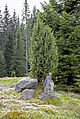
Gneiss formations of the Almboden
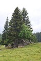
Juniper tree

In Filzmoos

Freiländer Alm reservoir


History and Development

The Freiländer Alm is 3 km². It consists of approx. 1 km² of alpine pasture, 1.85 km² of forest and other areas: the Filzmoos , the reservoir, the property of the alpine hut, including the stable and path connections. Another representation names 606 ha for the Freiländeralm, as well as a number of alpine pastures that are assigned to the individual farms of the catchment area.
A variant of the name is Freilander Alm , which preserves the name of the historically coherent "free country" , which was exempt from some obligations towards the sovereign because it belonged to Admont Abbey . In old documents, the area can also be referred to as Admonter Alm after this manorial rule, to which it belonged from the 13th to the 19th century . The land register uses the form Freiländer Alpe for the registration of the agricultural community . The spelling Freiländeralm is also used officially, for example by the agricultural district authority for Styria in a regulatory process.
Fleckvieh is the most common breed of cattle on the Freiländer Alm. In 1950, this breed replaced the Murbodner cattle , which had previously dominated . In 1954, over 80% of the total number of cattle belonged to the Murbodners. In 2003, 121 cattle spent the summer on this alpine pasture.
The pasture is by the Styrian Almschutzgesetz protected. It is entered in the Alm cadastre .
Since the 1930s, the center of the Hebalm alpine pasture has been relocated from the Hebalm chapel and forester's house here. The Hebalmkirtag was also held at the Rehbockhütte until 2015 .
Farmers community Freiländer Alm
The Freiländer Alm has been managed by farmers from the communities of Kloster , Freiland and Osterwitz since the 17th century (the three communities have all belonged to the city of Deutschlandsberg since 2015). They are united in an agricultural community . The community consists of 41 shares, which are inalienable in the land register with 35 farms (headquarters properties) in monastery (31 farms with 33 shares), Freiland (3/7) and Osterwitz (1/1). Two buoyancy rights are registered as easements in favor of the Roman Catholic parish of St. Oswald (in Freiland). The community is represented by its chairman, the Almobmann .
After the basic relief in Austria as a result of the revolution in 1848 ( peasant liberation ), the community existed on the basis of an imperial patent from 1853. The entry in the land register took place on the basis of the deed of April 21, 1885. The community was then based on the Styrian division and regulation ‑Landesgesetzes - TRLG reorganized and formally established. The Agricultural Community Act has been in force for the community since 1985.
Outdoor alpine hut

The buildings of this hut are the headquarters of the Almhalter on the Freiländer Alm.
These people are appointed by the farming community. They have the task of supervising (“keeping”) the cattle in the various pasture areas, keeping the fences in good condition and notifying the owner in the event of accidents, signs of illness, etc. Linked to this is the management of a simple restaurant business.
The water for the power station, which supplies the alpine hut and its outbuildings with electricity, is collected in the reservoir.
Wind farm and wind energy suitability zone Freiländer Alm

South of the Alm, the Freiländeralm wind farm has been on the Wolfsriegel (Blochriegel) since 2014 with 3 systems with a total nominal output of 6 MW , which is operated by Energie Steiermark . There are three Vestas V90-2MW with a total height of 150 meters and a rotor diameter of 90 meters.
In the development program for the field of wind energy (Sapro Windenergie) 2013, the entire summit corridor around the Alm was designated as the Freiländer Alm suitable zone for further expansion. It is one of the dozen or so mountain regions in Styria, in which at least a small expansion appears to be economically and environmentally compatible. The zone includes both the entire ridge of the Schwarzkogel from the existing wind turbines on the Hochriegel to the Wolfsriegel, as well as the northern Riedel from the Laurakogel over the summit of the Münzerkogel. It covers heights of 1400 to 1550 m and about 4 km². The zone falls into the communities of Deutschlandsberg and Hirschegg-Pack . Filzmoos, on the other hand, is a restricted zone as a protected area, as is the entire main ridge of the Koralpe in the Hebealm area as an important hiking area: Only the Handalm south is again designated as a priority zone for expansion.
Construction work in this area began in late summer 2013 (with the groundbreaking ceremony on September 23), and the facility opened on October 16, 2014.
The system produces 13 million kilowatt hours of electricity for around 3500 households, which can be fed into the power grid via a 16 km long line at the St. Martin am Wöllmißberg substation. A total of 9.5 million euros was invested, a special feature is the citizen participation model of Energie Steiermark, where customers can purchase share certificates.
Web links
Individual evidence
- ↑ Klug Lifte Hebalm - Freiländeralm ski area. bergfex.at.
- ↑ a b c d land register 61027 Klosterwinkel, District Court Deutschlandsberg, deposit number 19, as of November 2, 2007.
- ^ District topography. Second part of the volume. District Lexicon. Page 171.
- ^ Gerhard Fischer: Osterwitz. Page 336.
- ^ Agricultural district authority for Styria; Announcement on the conclusion of the procedure regarding the regulation of the agricultural community "Freiländeralm", EZ 19 KG 61027 Klosterwinkel. In: Grazer Zeitung , Official Gazette for Styria. 215th year, 26th piece. June 28, 2019, p. 362.
- ^ Atlas of Styria. Wilhelm Wolf, Georg Litscher: The cattle breeds of Styria. Map sheet no. 56. Graz 1957. According to documents from the Styrian regional chamber for agriculture and forestry.
- ^ District topography. First part of the volume. General part. Gerhard Fischer: peasantry, agriculture and forestry. Page 350.
- ↑ Law of 3 July 1984 on the protection of alpine pastures (Steiermärkisches Almschutzgesetz 1984). LGBl. No. 68/1984 in the version of the amendment LGBl. No. 58/2000 (status 2007, further amendments possible). Accessible under the legal information system RIS .
- ↑ Imperial Patent of July 5, 1853, Reichsgesetzblatt No. 130/1853, XLII. Piece from July 14, 1853, pages 737-746: effective for Austria above and below the Enns, Bohemia, Moravia, Silesia, Salicia and Lodomeria, Krakow, Styria, Carinthia, Carniola, Salzburg, Bukowina, Tyrol with Vorarlberg, Istria, Gorizia and Gradiska, and the city of Trieste with its territory, whereby the provisions on the regulation and redemption of the rights to purchase wood, pasture and forest products, and then some servitude and common property and use rights are established.
- ↑ Announced in the Styrian State Law and Ordinance Gazette stmkLGVBl. No. 44/1909 (XII. Issue, pages 99-143 of the year 1909): Law of May 26, 1909, valid for the Duchy of Styria, regarding the division of communal properties and the regulation of the related rights of use and administration. This law is available from the ALEX historical legal texts of the Austrian National Library.
- ↑ Steiermärkisches Agrargemeinschaftengesetz 1985 - StAgrGG, LGBl. No. 8/1986, in the version LGBl. No. 78/2001. Accessible in the legal information system RIS of the Republic of Austria.
- ↑ From West Styrian Holt for 'Halt (e), Viehweide'. According to Claus Jürgen Hutterer, Walter Kainz, Eduard Walcher †: West Styrian Dictionary. Grammar and vocabulary according to subject groups. In the series: Writings on the German language in Austria . Volume 13/14. Edited by Peter Wiesinger. Böhlau publishing house. Vienna-Cologne-Graz 1987. ISBN 3-205-07321-5 . Page 297.
- ↑ a b Freiländeralm wind farm - green energy for Styria. ( Memento of the original from September 1, 2016 in the Internet Archive ) Info: The archive link was inserted automatically and has not yet been checked. Please check the original and archive link according to the instructions and then remove this notice. e-steiermark.com (accessed August 31, 2016).
- ↑ Austro Control : Aviation Handbook Austria Aviation Information Service, directory of aviation obstacles ( page no longer available , search in web archives ) Info: The link was automatically marked as defective. Please check the link according to the instructions and then remove this notice. AIP AMDT 181, 8 MAR 2013 (PDF, 610 kB; accessed August 13, 2013).
- ↑ Ordinance of the Styrian state government of June 20, 2013, with which a development program for the field of wind energy is issued. LGBl. No. 72/2013 (as amended online, ris.bka ).
- ↑ West Styrian Rundschau . No. 8, year 2013 (February 22, 2013), 86th year, ZDB -ID 2303595-X . Simadruck Aigner u. Weisi, Deutschlandsberg 2013, p. 3.
- ↑ Office of the Styrian Provincial Government - Department 7 State and Community Development (Ed.): Development program for the field of wind energy . Ordinance, explanations, environmental report, LGBl. No. 72/2013. Graz 2013 ( web article , both raumplanung.steiermark.at - overview map also online EZ Freiländer Alm , jpg, accessed August 2016.). Web article ( Memento of the original from September 1, 2016 in the Internet Archive ) Info: The archive link was inserted automatically and has not yet been checked. Please check the original and archive link according to the instructions and then remove this notice.
- ↑ The stipulations are "Areas with good wind suitability and good infrastructural conditions (access, energy dissipation, etc.)" § 3 measures of Regulation 72/2013.
- ↑ Nature conservation procedure for the Freiländeralm wind farm. regionalentwicklung.at (undated around 2010; accessed August 31, 2016).
- ↑ a b Energie Steiermark relies on wind energy. steiermark.ORF.at, November 4, 2013.
- ↑ Wind farm on Freiländeralm before completion. steiermark.ORF.at, August 16, 2014.
- ↑ Opening of the wind farm. OTS broadcast, Austrian press agency APA OTS0164 Oct. 16, 2014, 12:24 pm.
- ↑ First wind farm: Green electricity for more than 3000 households. You will have to get used to it. In: Weststeirische Rundschau . No. 39, Volume 2013 (September 27, 2013), Volume 86, p. 1.