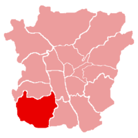
Straßgang
|
|||
| Basic data | |||
| Surface: | 11.75 km² | ||
| Residents: | 14,150 (January 1, 2017) | ||
| Population density: | 1,188 inhabitants per km² | ||
| Postcodes: | 8020, 8053, 8054, 8055 | ||
| Geographical location: | 47 ° 2 ' N , 15 ° 24' E | ||
| Location in Graz | |||
| District Office: | Kärntner Strasse 411, 8054 Graz | ||
| District Head: | Ferdinand Köberl ( ÖVP ) | ||
| 1. Deputy District Head: | Dieter Mandl ( SPÖ ) | ||
| 2nd deputy district head: | Michael Winter ( FPÖ ) | ||
| Public transportation: | Bus routes: 31 / E, 32, 62, 65 / E N2, N6 |
||
| photo | |||
| St. Martin Castle | |||
Straßgang (Slavic straža = waiting, watchtower) is the 16th district of Graz . It is located in the southwest of Graz at the foot of the Buchkogel and Florianiberg .
history
The town of Straßgang is located on an old traffic route that was already used in Roman times. The place, which was cultivated by the Aribones , was in 1055 by Emperor Heinrich III. this noble family revoked for participating in a rebellion and to the archbishopric of Salzburg transmitted. The name of the area around the southern Harterstraße (Hart, once Hartwigesdorf) goes back to its founder, Count Palatine Hartwig I of Bavaria († 985, forerunner of the Aribones in the Palatinate Office). In 1938, the village of Straßgang, together with Puntigam, became the 16th district of Graz. In 1988, Puntigam becomes a separate (17th) district of Graz.
Culture and sights
Buildings
- Church of Maria im Elend in Straßgang : Marienkirche with a Romanesque core from the early 12th century, extended in 1461 in the late Gothic style. In the north chapel an altarpiece by Hans Adam Weissenkircher (1686). The church and the cemetery are in a dominant position about 50 m above the town center.
- St. Martin Castle has been a provost of Admont Abbey since 1144 . In 1557 it was converted into a renaissance castle. The interior of the separately standing castle church from the years 1738–40 is one of the main works by Josef Stammel . In the 19th century, the large-scale park near the ponds ( proven ad Wiarn since 1185), which was designed with numerous ponds, avenues and grottoes around the source of the Bründlbach, belonged to the castle. Since 1914 the building has been used as a home for people's education. It has been owned by the Province of Styria since 1936 .
- St. Florian Church (1597)
- Rupertikirche : First mentioned in a document in 1354, but the core of the building is early Romanesque or even Carolingian (end of the 9th century), so it is perhaps the oldest church in the Graz city area.
Economy and Infrastructure
- smaller industrial and commercial enterprises e.g. B. Printing works Alfred Wall AG and Leykam , Elin (electrical products), Wo & Wo , Fischer & CO (air conditioning), MEWA
- Service companies
- some shopping malls
- LKH Graz II location south vorm. Landesnervenklinik Sigmund Freud (LSF): State nerve hospital, established in 1872 as the "Asylum Am Feldhof".
- On the Kehlberg, the southern slope of the Buchkogel , is one of only two wine-growing regions in Graz.
- Agricultural and forestry college Alt-Grottenhof
- Kärntner Straße (main road to the south-west) and the city motorway , a section of the A 9, represent a major traffic load for the district.
- South portal of the Plabutsch tunnel on the Pyhrn Autobahn (opened in 1987)
- Bus routes 31, 32, 62 and 65.
- The Graz-Köflacher Railway , which was originally built to transport coal from the Köflach mining area, is now a fast means of transport to downtown Graz and western Styria .
- Natural pool with a water surface of 11,000 m², natural gravel floor, large green areas.
- Location of the Styrian regional control center of the Red Cross , which centrally coordinates the rescue service in the state from here, as well as an ambulance station .
Individual evidence
- ↑ Numbers + facts: population, districts, economy, geography on graz.at.
- ↑ a b c District councils in the Straßgang district on graz.at ( Memento of the original from 23 August 2017 in the Internet Archive ) Info: The archive link was inserted automatically and has not yet been checked. Please check the original and archive link according to the instructions and then remove this notice.
- ↑ Heinz Dopsch
- ↑ Alois Köbl, Wiltraud Resch, Attila Mudrák: Paths to God: the churches and the synagogue of Graz , Graz 2002, p. 228. ISBN 3-222-13105-8 .


