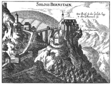
Topographia Austriae superioris modernae
The Topographia Austriae superioris modernae is a collection of 222 copper-engraved views ( topographies ) of cities, monasteries, lordships and castles that belonged to Upper Austria at that time . The author is Georg Matthäus Vischer . The title page is followed by an imperial privilege and a table of contents (number and order).
history

In 1667 Vischer had signed a contract for a national map with the estates of the Archduchy of Austria ob der Enns (historical name of Upper Austria ). This Archiducatus Austriae Superioris Descriptio facta Anno 1667 appeared in 1669 and remained the authoritative map series for over a hundred years; an updated edition appeared in 1808. At the same time, Vischer worked on views of Upper Austrian cities, monasteries, lordships and castles. In Leonstein (today Grünburg ) Vischer had a pastorate held and received the approval of Passau he Ordinariate and Count George of Salburg to employ a temporary pastor. In addition, the Obderennsischen estates allowed him to move freely in the country. At the end of 1668, however, he lost his pastor and got into a tense financial situation, and there was less interest in views than in maps. In addition, there were economic crises and threats from Turks , so the Topographia Austriae superioris modernae appeared late in 1674, based on a Lower Austrian topography by Vischer. The original copper plates became the property of the Obderennsischen estates and are now in the Upper Austrian Provincial Archives.
pads
The drawings were engraved between 1669 and 1674 in Augsburg in various workshops of varying quality, and Vischer also took over some of the engravings from Matthäus Merian's Topographia Provinciarum Austriacarum . He supplied his clients with 150 copies at 5 guilders each , and he is likely to have earmarked just as many for sale of other value. In 1677 a second edition appeared with minor changes and in 1709 an updated version with changes in ownership of the rulers taken into account. Linz reprints based on the original copper plates were made in 1826 and 1832. In 2005 a reprint was published by the Vienna Archive Verlag .
particularities
It was important to Vischer that the buildings be reproduced correctly. Landscapes such as rivers, lakes, mountains, forests, etc., on the other hand, often appear distorted and with a wrong perspective. It is unusual that the views are not accompanied by descriptions, perhaps to avoid errors.
literature
- Georg Matthäus Vischer: Topographia Austriae superioris modernae. Augsburg 1674, digitized version from the University of Vienna.
Web links
- Digitized version of the University of Vienna. Accessed April 14, 2012.

