
Leonstein (municipality of Grünburg)
|
Leonstein ( village ) village cadastral community Leonstein |
|||
|---|---|---|---|
|
|||
| Basic data | |||
| Pole. District , state | Kirchdorf an der Krems (KI), Upper Austria | ||
| Judicial district | Kirchdorf an der Krems | ||
| Pole. local community | Grünburg | ||
| Coordinates | 47 ° 53 '39 " N , 14 ° 13' 43" E | ||
| height | 444 m above sea level A. | ||
| Residents of the village | 1776 (January 1, 2020) | ||
| Area d. KG | 16.24 km² | ||
| Post Code | 4592 Leonstein | ||
| Statistical identification | |||
| Locality code | 09658 | ||
| Cadastral parish number | 49007 | ||
| Counting district / district | Leonstein (40902 002) | ||
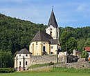
 The town center with the parish church |
|||
| Source: STAT : index of places ; BEV : GEONAM ; DORIS | |||

Leonstein is a village, a locality and a cadastral municipality in the municipality of Grünburg in Upper Austria . The area borders in the south ( Steyr breakthrough ) and west on Micheldorf , in the east on Molln and in the north near Schloss Leonstein on the village of Obergrünburg.
history

.jpg)
Around 1320 the Rohrers, who owned the " Veste Leonstein ", built a church in Romanesque style and a cemetery chapel. The church was first a branch church of Syrnicht ( Sierning ) and from 1367 independent and its own pastoral care station.
In 1390 the Leonstein fortress was founded by Duke Albrecht III. besieged and finally destroyed, as emissaries of the Archbishop of Salzburg were imprisoned there. At that time, a cannon was used for the first time in Austria. Wolfgang von Rohr finally sold his share in the castle to the Duke, the other part belonged to his brother Wilhelm, who had fled. In 1397 Albrecht III enfeoffed Wolfgang von Rohr again. Erhard von Zelking acquired half of the rule from Bernhard von Rohr in 1447 . Instead of the Feichta farmhouse, the Zelkingers built Leonstein Castle, which still exists today. A state children's home has been housed there since 1945.
Since 1624 Leonstein was again a Catholic pastoral care station in the course of the Counter Reformation and in 1628 the Protestant baron Christoph von Zelking emigrated. The Catholic Lords of Salburg followed.
Georg Matthäus Vischer, now known as a cartographer, was pastor in Leonstein from 1666 to 1668 . Beer has been brewed since 1731 under the count's rule of the Salburgers, who also owned the Klaus rule . The last brewery in Leonstein closed in 1907. Today's scythe forge museum ( Ensemble Schmiedleithen ) is also located in part on Leonsteiner local area, otherwise directly on the border in Obergrünburg.
Name and location
The place and parish are named after the former castle or today's palace. In the deed for the elevation of the parish in 1367, however, the parish and church are still called "To Saint Stephen an der Wienne". The southern border to Micheldorf ( KG Obermicheldorf) runs on the Steyr breakthrough valley crossing . The border to Molln is formed by the Steyr river , the northern border by the Rinnerbach (Schmiedleitnerbach).
Buildings
Listed buildings
- Leonstein parish church . Hambaumstrasse 2
- Vicarage, Kirchenweg 6
- Hasengütl farm with sgraffiti from the early 17th century
- Scheiterhütte from the Schmiedleithen ensemble (Schmiedleithen open-air museum)
Parish church

Rectory

Hasengütl farm

Funeral hut


Bridges (in whole or in part in the local area)


- Road bridge over the Schmidleithenbach (southern bridgehead)
- Cycle bridge over the Schmidleithenbach (also)
- "Römerbrücke" at Leonstein Castle
- Stefanie Bridge near Molln (western bridgehead)
- Plangrabenbrücke of the Steyrtal cycle path
- Steyr breakthrough valley crossing (northern bridgehead)
- Tiefengrabenbrücke of the Steyrtal cycle path (also)
Infrastructure
- Steyrtal police station
- Leonstein volunteer fire brigade
- State Music School Grünburg
- Elementary school
The Leonstein outdoor pool is located in the center of the village below the music school. On the bike path near Leonstein Castle, by the Friends of Nature House, there is a skate area .

Steyrtal police station
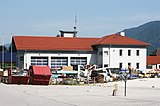
Fire station

State Music School Grünburg

Elementary school


.jpg)
Transport and energy supply
The Steyrtal state road B 140 and the Steyrtal cycle path run through the entire local area . This leads mostly on the former route of the Steyrtalbahn .
The Agonitz run-of- river power plant at river kilometer 32 has existed since 1924 and has been owned by Energie AG Upper Austria since 1996 . In the years 2003–2004 the new owner had the power station renovated and mostly rebuilt. Two sets of machines were installed: a Kaplan turbine with 2550 kW and a so-called straflo matrix turbine with 550 kW. The output increased from 990 kW to 3100 kW. The power plant generates 15.8 GWh of electricity annually.

The Steyrtalstraße shortly after the town center

The former train station Leonstein, on the right the Steyrtal cycle path

Agonitz power plant


nature
The western side of the Steyrschlucht nature reserve lies from the mouth of the Rinnerbach (Schmiedleitnerbach) to the Agonitz power station in the local area. The eastern side belongs to Molln (KG Auserbreitenau and KG Molln). The flat meadows with spacious, semi-arid grassland and pine forests are also a nature reserve.

Steyrschlucht near the Agonitz power station (left Leonstein, right Molln)

Steyrschlucht at the level of the center of Leonstein (left Leonstein, right Molln)
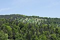
Planwiesen (view from near Steyrbruch)


Web links
Individual evidence
- ↑ a b Grünburg - Leonstein Church, accessed on May 24, 2011
- ↑ Wilibald Girkinger, Wolfgang Heitzmann: The Steyr. Landscape and people on the river. Landesverlag, 1990, ISBN 3-85214-527-9 , p. 112 f.
- ^ Leonsteiner Pfarrbrief, Christmas 2004. In: Franz Wagner: Leonstein. 1907, p. 16.
- ^ Georg Matthäus Vischer: Topographia Austriae superioris modernae Archiv Verlag, 2005 (reprint) Commentary by Klaus Rumpler p. 3f.
- ↑ Heimatblätter: Beer from Leonstein. The brewery in Leonstein 1731 - 1907. No. 1. Volume 2005, p. 5f.
- ↑ schmiedleithen.at viewed on May 24, 2011
- ↑ Limits according to doris.at
- ↑ Scientific activity and home care in Upper Austria 1960. In: Yearbook of the Upper Austrian Museum Association. 106th Volume, Linz 1961, p. 75 ( online (PDF) in the forum OoeGeschichte.at, accessed on September 22, 2019).
- ↑ Technology in the Agonitz power plant on the Steyr ( Memento of the original from December 14, 2013 in the Internet Archive ) Info: The archive link was automatically inserted and not yet checked. Please check the original and archive link according to the instructions and then remove this notice. (PDF; 603 kB) accessed on July 30, 2011
- ↑ “Steyrschlucht” officially a nature reserve since Saturday, February 27, 2016 on land-oberoesterreich.gv.at. Cadastral boundaries according to doris.at (accessed on December 3, 2019)
- ^ Province of Upper Austria - nature conservation database viewed on December 3, 2019