
Rinnerbach (Steyr)
|
Rinnerbach Rinnerberger Bach; Schmiedleit [h] ner Bach (lower course) |
||
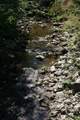
 Shortly before the mouth at the Roman bridge in Priethal |
||
| Data | ||
| Water code | AT : HZB: 2-134-326-068, GGN: 1147 | |
| location | Traunviertel , Upper Austria | |
| Drain over | Steyr → Enns → Danube → Black Sea | |
| River basin district | Danube below Jochenstein (DUJ) | |
| origin | in Altpernstein near Micheldorf 47 ° 54 '2 " N , 14 ° 9' 35" E |
|
| Source height | approx. 760 m above sea level A. | |
| muzzle | in Priethal , Grünburg Coordinates: 47 ° 54 '26 " N , 14 ° 14' 11" E 47 ° 54 '26 " N , 14 ° 14' 11" E |
|
| Mouth height | 370 m above sea level A. | |
| Height difference | approx. 390 m
|
|
| length | 8.7 km | |
| Left tributaries | Heindlmühlbach , Haselgrabenbach | |
| Right tributaries | Schwarzgrabenbach | |
| Communities | Micheldorf in Upper Austria , Grünburg | |
The Rinnerbach , also Rinnerbergerbach (Rinnerberger Bach) , on the lower reaches Schmiedleitnerbach ( Schmiedleitner Bach , also Schmiedleithnerbach ), is a tributary of the Steyr near Micheldorf and Leonstein in the southern Traunviertel in Upper Austria .
Run and landscape
The Rinnerbach rises in the village of Altpernstein , in the Kremstal-right bank of the mountains above Micheldorf and Kirchdorf , in the hollow between the Hirschwaldstein and the Oberhammet , at about 760 m above sea level. A. .
It turns eastwards and takes the Schwarzgrabenbach vom Hirschwaldstein at the locality Rinnerberg . Then it breaks through northeast in the Rinnerberger Klamm between Rinnerberg and Sonnkogel . Here he also trains the Rinnerberg waterfall .
At the end of the gorge, it takes up the Heindlmühlbach von Hausmanning, which runs parallel to the north . At the southern end of the widening of Pernzell , where the Haselgrabenbach joins at Furth , it turns southeast. Pernzell is a valley watershed to the Steyrleithenbach . The following valley widening between Sonnkogel and Großem Landsberg is called Schmiedleiten , and the stream here is also called Schmiedleitnerbach.
It then passes the Leonsteiner Burghügel ( local mountain) south, the name here is Prietal . There, at Leonstein Castle , after a good 8½ kilometers it joins the Steyr between Leonstein / Molln and Obergrünburg .
geology
The stream originates still in flysch ( Almtaler and Kirchdorferfeld Flyschberge ), and then following the disturbances of the edge scales of Hauptdolomit by weight of the Enns and Steyr Taler foothills , here Helvetic colored marl at the source, cement marl and Altlengbach of flysch, Cenomanian , and various Tyrolean layers ( Dachstein limestone and companion to Wetterstein des Rabenstein and Schauderzinkens). Rinnerberg and Sonnkogel are mainly the main dolomites. These rocks determine the various gradients of the stream and its tributaries.
history
Historically, the names Klingelbach am Unterlauf, and Auwiesenbach am Micheldorfer Oberlauf.
The brook has always been the border between the dominions of Grünburg and Leonstein, and on the upper reaches also between Leonstein and Pernstein . The parish (and then locality and cadastral) boundaries between [Upper] Grünburg and Leonstein ran accordingly .
The brook has good water supply and was one of the more important works brooks on the upper Steyr. In the middle of the 18th century there were four iron hammers, five mills and three saws: four plants in Priethal, the plant in Schmiedleithen, which now forms the open-air museum , four in Furth, and the mill in Rinnerberg.
The “ Römerbrücke ” from 1787 in Priethal has been preserved from the old Steyrtalstrasse .

The waterfall

View from the footbridge below the waterfall

Historic Schmiedleithen weir system
Underwater at Schmiedleithen


literature
- Josef Zeitlinger: The Schmiedleitnerbach in Leonstein. Monograph of a small mountain stream and its surroundings. In: Jahrbuch des Oberösterreichischen Musealverein 109, 1963, pp. 372–424, PDF on ZOBODAT - with a number of maps, historical illustrations in particular panels XXV f after p. 401, XXVII ff after p. 416 (pdf p. 32 and 50 respectively ) .
Web links
Individual evidence
- ↑ DORIS, Subject Waters , Layer Small Waters and Detailed Catchment Areas (accessed October 5, 2018).
- ↑ a b Rinnerberger Bach in the Austrian map (2018) and in the area directory (catchment areas); Rinnerbach along its entire length in the water book and in basemap.at; Schmiedleitnerbach, as is customary in the area, about Lit. Zeitlinger 1963, there also Rinnerbergerbach , p. 380, and “in old time” Klingelbach , p. 374.
- ↑ a b c The corresponding locations are still spelled with "th" today.
- ↑ Detailed Austrian. Geological map and Lit. Zeitlinger, 1963, Chapter II. Geological and morphological foundations , S, 378 ff (pdf p. 9 ff).
- ^ Souvent: Administrative map of the Archduke of Austria ob der Enns (1857) gives Rinderberger Bach (this Rin [n] erberg / Rinderberg can also be found at the farms in Rinnerberg), and Auwiesenbach for the upper reaches, the Schwarzgrabenbach as Sünderbergerbach ; these names do not come from the Franciscan cadastre (DORIS, subject of first land surveys ).
- ↑ Lit. Zeitlinger, 1963, Chapter II. Historisches und Wirtschaft , p. 374 (pdf p. 3).
- ↑ Lit. Zeitlinger, 1963, p. 375 (pdf p. 4).