
Christkindl
|
Christkindl ( district ) cadastral community Christkindl Statistical district Christkindl / Schlühslmayr |
|||
|---|---|---|---|
|
|||
| Basic data | |||
| Pole. District , state | Steyr (city) (SR), Upper Austria | ||
| Judicial district | Steyr | ||
| Pole. local community | Steyr | ||
| Locality | Steyr | ||
| Coordinates | 48 ° 2 '16 " N , 14 ° 23' 0" E | ||
| height | 347 m above sea level A. | ||
| Residents of the stat. An H. | 1834 (May 15, 2001) | ||
| Area d. KG | 1.59 km² | ||
| Post Code | 4400 Steyr | ||
| Statistical identification | |||
| Cadastral parish number | 49203 | ||
| Counting district / district | ON (40201 12) | ||
 Center pilgrimage church and parish home |
|||
| Place Christkindl is a small hamlet; District with Unterhimmel , Christmas settlement , Schlühslmayrsiedlung ; Districts also in Garsten , part of that municipality until 1938; Counting district a little larger than the KG (shares in Steyr and Sarning ), old name: VII.Bez .: Christkindl ; Special post office 4411 Christkindl Source: STAT : Place directory ; BEV : GEONAM ; DORIS ; City of Steyr |
|||

Christkindl is a place in the Lower Steyrtal in the Traunviertel of Upper Austria , as well as the district and cadastral municipality of the statutory city of Steyr , as well as a place (cadastral municipality Oberchristkindl ) of the municipality of Garsten in the Steyr-Land district .
The place is known for the pilgrimage church Zum Christkindl unterm Himmel and the special post office 4411 Christkindl , which is the address for Austrian children for Christmas wishes.
geography
| Oberchristkindl ( cadastral parish ) | |
|---|---|
| Basic data | |
| Pole. District , state | Steyr-Land , Upper Austria |
| Judicial district | Steyr |
| Pole. local community | Cooked |
| Coordinates | 48 ° 1 ′ 51 ″ N , 14 ° 22 ′ 56 ″ E |
| Area d. KG | 2.35 km² |
| Statistical identification | |
| Cadastral parish number | 49224 |
| Locations Christkindl, Garsten Nord Source: STAT : Directory of places ; BEV : GEONAM ; DORIS |
|
|
Christkindl ( scattered houses ) village |
|
|---|---|
| Basic data | |
| Pole. District , state | Steyr-Land (SE), Upper Austria |
| Judicial district | Steyr |
| Pole. local community | Garsten ( KG Oberchristkindl) |
| Coordinates | 48 ° 2 '7 " N , 14 ° 23' 22" E |
| height | 350 m above sea level A. |
| Residents of the village | 496 (January 1, 2020) |
| Post Code | 4400 Steyr |
| Statistical identification | |
| Locality code | 11912 |
| Counting district / district | Garsten-Zentralgebiet-W, Garsten-West (41506 X [001,002]) |
| Districts since 1938 also in Steyr Source: STAT : Ortverzeichnis ; BEV : GEONAM ; DORIS |
|
The place is located around 2 km west of the Steyr city center and just as far northwest of Garsten , at the foot of the Saaß ridge (Oberfeld, approx. 480 m above sea level ).
The actual place Christkindl is located on a hill above the Steyr river to around 350 m above sea level. A. Height. The Hofergrabenbach goes south to the Steyr. The place consists of a small hamlet with about 20 houses that belong entirely to Steyr, and some surrounding farmsteads and groups of houses on Aschacher Strasse (Wegener, Reiter, Obersteinwand) , some of which also belong to Garsten.
The Steyr district Christkindl also includes Unterhimmel an der Steyr, the Christkindl settlement towards the city and the Schlühslmayr settlement above towards Garsten. This district corresponds to the cadastral community of Christkindl with 159 hectares , and the statistical district of Christkindl, Schlühslmayr (zone: Christkindl / Schlühslmayr ). The latter is somewhat more extensive towards the city than the cadastral community, the demarcation largely follows the Teufelsbach , and includes small parts of the cadastral areas Sarning and Steyr . The district has about 2000 inhabitants.
The Garsten part forms an independent village. These scattered houses also include the Mösing houses , the settlement towards Saaß around the Christkindl regional care and care center , and other scattered locations . This place has 420 inhabitants. The corresponding cadastral municipality of Oberchristkindl is even larger with 235 hectares , it also includes the village of Garsten Nord (about 450 inhabitants).
|
Gründberg ( O and KG, Gem. Sierning and Stt., Std. Steyr, KG Föhrenschacherl ) ∗
Steyr
|
Steyrdorf (Stt., Std. Steyr) |
|
|
Rosenegg (O, Gem. Garsten)
|
.svg)
|
Inner City (Stt., Std. Steyr)
|
| Saaß (O, Gem. Garsten) ∗∗∗∗ |
Garsten North (O, Gem. Garsten)
|
- ∗The Sierninger Kat.Gem. In the northwest, Gründberg only borders the bridge at the Krugl weir at one point.
- ∗∗ KG Steyr stretches north of the Steyr River to the north of Christkindl, and in the east also includes the inner city.
- ∗∗∗ KG Pergern borders KG Garsten in the south, the place is behind Garsten Nord.
- ∗∗∗∗Also Ortsch, Gem. Aschach an der Steyr , this is behind.
- ∗∗∗∗∗ Also Ortsch, Gem. Garsten, this is behind Garsten Nord.
history
.png)
The foundation goes back to a miraculously venerated figure of Jesus Christ in the hollow of a spruce tree and the construction of the pilgrimage church in the 1700s by Garsten Abbey . The former name of the hill on which the church stands today is "Wald Underm Himel". The name "Unterhimmel", which is still used today, has been used for the underlying wetland along the Steyr River since 1577, presumably as a demarcation to the hilly areas ( sky , 'open corridor'). The church itself is called Zum divine Christkind , locally also called Zum Christkindl unterm Himmel . There was also a hermitage here, but it has been an inn since the 18th century.
In 1785 a parish district was established, and in 1887 Garsten Abbey was abolished. As a result, the independent tax community was established , which then became part of the local community of Garsten in 1850 . Christkindl has been a pastor since 1891.
In 1891 the Steyrtalbahn was also built in Unterhimmel , a narrow-gauge line that connected the Rudolfsbahn in Ennstal and the Kremstalbahn. The Christkindl stop was located here.
After the Nazi annexation , the northern part of Christkindl with the Kirchweiler came to the city of Steyr on October 15, 1938, and there became the 7th district of Christkindl with the districts of Christkindl and Unterhimel. After the end of the war, this part remained with Steyr.
The Christkindl settlement was built after 1945.
The place has gained international fame since 1950, when the Austrian Post set up the Christkindl special post office with 42,000 dispatched items. In fact, they were letters written by children as a Christmas wish. This post office (4411 Christkindl) is open every year during Advent and Christmas time and stamps the letters that are sent through it with a special stamp . Every year around 2 million items receive this special cancellation today.
Since the new city statute in 1992, Christkindl is no longer listed as the VIIth district in the city of Steyr, but continues to operate as the statistical district Christkindl, Schlühslmayr (No. 12), taking into account the now extensive settlement on the Schlühslmayr grounds.
Infrastructure, culture and sights
Buildings

In Kirchweiler:
- The pilgrimage and parish church was built 1702–1709 according to plans by Carlo Antonio Carlone and Jakob Prandtauer . The direct model was Agrippa's Roman pantheon . Since this happened without the episcopal approval, a building ban was issued by the episcopal curia in May 1703 . It was not until April 16, 1708 that the long-awaited permit was obtained.
- To the south of the church is the parish hall with an outbuilding from the construction period.
- There is a Loretto chapel in front of the church .
- The former hermit's house on the rocky promontory west of the church has been an inn for around 200 years; it has been owned by the Baumgartner family since 1964, and their descendants expanded it into a hotel in 2008. Previous owners were J. Strahofer and from 1931 to 1964 David . In the 1950s, the name of the house was still Gasthof zur Schöne Aussicht , today the hotel is called Christkindlwirt. The Christkindl post office has also been housed in this building since 1951 .
- At the Christkindlwirt there is the Engelsstiege , which leads up from Unterhimmel.
- The cemetery, which also comes from the Baroque era, is a bit away from the church. At the cemetery there is another inn, the Christkindlhof.
- A little further to the west is the Nepomuk Chapel .

In Unterhimmel there are early modern industrial buildings and the systems of the Steyrtalbahn , which operates today as a museum railway.
Natural space
The Unterhimmler Au (Himmlitzer Au) together with cultivated land and the Christkindl hillside forest is a sanctuary complex (nature reserve Unterhimmler Au , protected landscape under heaven , protective forest Christmas and European nature reserve). It also plays a central role in the city's flood protection. The Au and the area around the village of Christkindl are an important recreational area.
A little to the east of the church is an old red beech in the hillside forest ( ND 631 ), which has been designated a natural monument .
Events and exhibitions
- Christmas post office, open from 1st Advent to Epiphany (6th January)
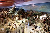
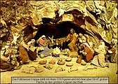
Christmas cribs can be viewed in the outbuilding of the parish hall :
- Mechanical crib by Karl Klauda. Thanks to an ingenious mechanism with bicycle chains, shafts and gears, almost 300 figures carved from linden wood move through a detailed biblical landscape.
- Large crib by Ferdinand Pöttmesser . The oriental landscape crib with an area of 58 m² offers space for 778 up to 30 cm tall, carved and clothed figures of the South Tyrolean Ferdinand Pöttmesser.

Mechanical crib by Karl Klauda
Pöttmesser Nativity
Pöttmesser Nativity (detail)


Every year at the beginning of December, the balloon launch of St. Nicholas instead. This event is popular among the children.
Sports
The local soccer club 1. FC Christkindl was founded in 1974 and is well known in the Steyr region . In recent years, the club has achieved great success in regional football through targeted youth development .
Personalities
- Franz Xaver Mitterecker (born November 27, 1807 in Christkindl; † April 9, 1876 in Faistenau ), vicar of Rauris (1852–1857) and at the Faistenau parish church (1857–1876).
- Miriam Hie (* 1978), presenter and actress
Web links
- Post office Christkindl christkindl.at
- Parish Christkindl dioezese-linz.at
- Entry on Christkindl in the Austria Forum (in the AEIOU Austria Lexicon )
Footnotes and individual references
- ↑ a b c See statistical districts. Statistical Zones. Statistical counting districts. Magistrat Steyr, planning date 2008 (all pdf, accessed July 8, 2018).
- ↑ a b See area development of the city of Steyr. Magistrat Steyr, planning date 2008 (pdf, accessed July 8, 2018).
- ↑ Christine Grüll: It's good to live in Unterhimmel. ( Heaven on Earth series - A journey to places with “heavenly references” , part 1 of 5). In: KirchenBlatt No. 31 (2011), August 3, 2011 (online, kath-kirche-vorarlberg.at, accessed September 3, 2018).
- ^ A b Wilhelm Rausch , Hermann Rafetseder: Area and name changes of the municipalities in Austria since the middle of the 19th century. Volume 2 of the Austrian Working Group for Urban History Research , Ludwig Boltzmann Institute for Urban History Research : Research on the history of cities and markets in Austria. 1989, ISBN 3-900387-22-2 , p. 260 ( limited preview in Google book search).
- ^ Ordinance of the Provincial Governor of Upper Austria of September 30, 1938 on the unification of areas of the local communities Garsten, Gleink and Sierning with the township of Steyr. VOBl. No. 61/1938 14th piece, p. 44 f (entered into force October 15 of this year according to § 7 and § 2 VOBl. No. 63/1938; EReader, ALEX Online ).
- ↑ Manfred Brand: New History of Steyr. Verlag Ennsthaler, Steyr 1980, ISBN 3-85068-093-2 , p. 160.
- ↑ a b Section 1, Paragraph 2 of the Act on the Reinstatement of the Municipal Statute for the City of Steyr, enacted by the Act of March 18, 1930, LGBl. No. 13/1930. LGBl. No. 41/1948 20th issue (pdf, ris.bka ; retroactively effective January 1, 1946).
- ↑ Steyr. In: Vienna City and State Archives, Ludwig Boltzmann Institute for City History Research: Austrian City Atlas ; Chapter The development of the suburbs of Steyrdorf and Ennsdorf as well as the suburbs and fortifications, last paragraph (online mapire.eu).
- ^ Rudolf Lehr: Landeschronik Oberösterreich , Verlag Christian Brandstätter, Vienna 2008, ISBN 978-3-85033-230-9 , p. 372.
- ↑ Announcement of the above State government on the republication of the statute for the city of Steyr. LGBl. No. 9/1992 6th issue (as amended online, ris.bka ).
- ↑ a b Raimund Ločičnik: The Steyrtal. Sutton Verlag, Erfurt 2010, ISBN 978-3-86680-647-4 , p. 109.
- ↑ Restaurant sign on a photograph from 1930: J. STRAHOFER RESTAURATION . In: ops.cit. Ločičnik: Das Steyrtal 2010, p. 108.
- ↑ Franz Xaver Mitterecker was born in Unterhimmel 28 . See: Taufbuch Steyr Christkindl 101/01, p. 161 data.matricula-online.eu .

Cadastral municipalities: Garsten | Lahrndorf | Mühlbach | Oberchristkindl | Pergern | Unterdambach
Locations: Buchholz | Christkindl | Garsten | Garsten North | Kraxental | Lahrndorf | Mühlbach | Mühlbachgraben | Oberdambach | Pergern | Pesendorf | Rosenegg | Saass | Sand | Sarning | Schwaming | Sonnberg | Tinsting | Unterdambach | Unterlaussa
Market place: Garsten | Villages: Pergern • Rosenegg • Schwaming | Rotten: Garsten North • Lahrndorf • Sarning • Strasser • Tinsting • Unterdambach | Settlements: Buchholz • Höllsiedlung • Sand | Group of houses: Kraxental | Scattered houses: Angern • Christkindl • Käfergraben • Mühlbach • Mühlbachgraben • Oberdambach • Pesendorf • Saaß • Sonnberg • Unterlaussa | Other locations: State nursing home • Enns power station Rosenau • Rosenegg Castle
Counting district: Garsten-Zentralgebiet-O | Garsten-Zentralgebiet-W | Garsten-West | Garsten-South
Historical locations: Gweng / Weng

Location: Steyr
Cadastral parishes: Christkindl | Föhrenschacherl | Gleink | Hinterberg | Jägerberg | Sarning | Stone | Steyr
City districts (settlement identification) :
Christkindl •
Ennsleite •
Gleink •
Gründberg •
Hausleiten •
Münichholz •
Place •
Pyrach •
Stein •
Steyr •
Steyrdorf
Rotten:
Damm •
Dornach •
Haidershofen •
Maria im Winkl •
Neustift •
Weinzierl |
Settlement:
horticulturist |
Other locations:
Christkindlsiedlung •
Eisenfeld ( Karolinental ) •
Fischhub •
Gründbergsiedlung •
Neuschönau •
Ramingsteg •
Reichenschwall •
Resthof •
Sarning •
Schlühslmayrsiedlung •
Schlüsselhof •
Steyrwerke •
Tabor •
Unterhimmel •
Waldrandsiedlung •
Wehrgraben
Statistical districts (municipality structure): Innere Stadt | Steyrdorf | Tabor (west) , Stein (south) | Tabor (east) , Resthof | Ennsdorf , Ennsleite , Fischhub | Pyrach , Reichenschwall | Christkindl , Schlühslmayr | Gründbergsiedlung | Stone , gleink | Winkling / Hausleiten | Münichholz / Hinterberg
Statistical zones (municipal structure): Inner City | Steyrdorf | Weir ditch | Old Tabor | Tabor Resthof | Ennsdorf | Fish lift | Forest edge settlement | Ennsleite | Neuschönau | Pyrach / Reichenschwall | Christkindl / Schlühslmayr | Gründbergsiedlung | Steyr-Gleink | Winkling / Hausleiten | Münichholz | Hinterberg / Hammer | Schlüsselhof location | stone
City districts and counting districts (old): I.Bez .: Inner City | II.ez .: Steyrdorf | III.Dec .: Stone | IV.Dec .: Place | V.Bez.:Ennsdorf (with ZBez V.Bez.:Ennsleite ) | VI.Dec .: Pyrach | VII.Dez.:Christkindl | VIII.Bez .: Grundberg | IX.Des .: Gleink | X.Bez .: Hausleiten | XI.Bez .: Munichholz
Former communities: Jägerberg 1851–1857 • Gleink 1851–1938 | Historical locations: Aichet • Aussersteyrdorf • Bei der Steyr • Josefstal • Hammer • Ramingdorf • Schönau ( Kühberg ) • Vogelsang • Wieserfeld