
Under heaven
| Under sky (location component ) | |||
|---|---|---|---|
|
|||
| Basic data | |||
| Pole. District , state | Steyr (city) (SR), Upper Austria | ||
| Judicial district | Steyr | ||
| Pole. local community | Steyr ( KG Christkindl ) | ||
| Locality | Steyr | ||
| Statistical district | Christkindl, Schlühslmayr | ||
| Coordinates | 48 ° 2 '28 " N , 14 ° 23' 9" E | ||
| height | 297 m above sea level A. | ||
| Post Code | 4400 Steyr | ||
| Statistical identification | |||
| Counting district / district | oN (40201 12 [0]) | ||
| approx. 45 addresses (2018) 46 Source: STAT : Local directory ; BEV : GEONAM ; DORIS |
|||

Unterhimmel is a place in the Steyrtal in the Traunviertel of Upper Austria , and belongs to the statutory city of Steyr .
geography
The place is located 2 kilometers west of the inner city . It is located directly north of Christkindl , below the river terrace on the banks of the Steyr , at around 300 m above sea level. A. Height. A former mill channel, the Alte Steyr , also known as the Himmlitzer Bach or Fischerbach, runs through the village .
The place has about 45 addresses.
| Gründbergsiedlung (Stt. Gründberg ) | Steyrdorf (Stt.) | |
| Rosenegg ( Gem.Garsten , district Steyr-Land ) |
.svg)
|
Christkindlsiedlung |
| Christkindl |
History, infrastructure and nature
The name stands for the sky , open corridor ', and was first used in 1577. Today Christkindl Kirchberg was forest Underm Himel called. The name Himmlitzer Bach is probably derived from heavenly "weather lights".
Unterhimmel with the Mühlgerinne (historically also Wehrgraben ) was an important industrial area. The paper mill was founded as early as 1636 . There was also a copper hammer, then 1787–1799 scythe works. By 1850 there were a total of five water wheels on the creek. Josef Werndl, founder of the Steyr arms factory (Steyr-Werke), set up the wire drawing plant (semi-finished products for nail manufacture) here in 1874 . Both objects are now under monument protection .
In 1889 the Steyrtalbahn was built here, a narrow-gauge line that connected the Rudolfsbahn in Ennstal and the Kremstalbahn. ( Garsten - Klaus and Bad Hall ). The Unterhimmel -Christkindl stop was built in Unterhimmel . This railway operated until 1982, and again since 1985 as a museum railway with steam trains, the route is also listed (on both sides of the newly built stop). The Christkindler Post Office was also located at the stop from 1894 onwards, which was closed again in 1973 (the special post office opened in 1950). The Steyrbrücke leads to Unterhimmel from Steyrdorf ( Black Bridge , Drahtzieherstraße).
Unterhimmel originally belonged to the Christkindl community , since 1938 it has been part of the city of Steyr.
In Unterhimmel, the Steyr has one of the most important natural-renatured flow stretches , the Unterhimmler Au (Himmlitzer Au) . In 2009, a tributary was created here to prevent the city from flooding. The Au together with cultivated land and the Christkindl hillside forest is a sanctuary complex (nature reserve Unterhimmler Au , protected landscape under heaven , protective forest Christmas and European nature reserve).

Museum train , behind the pilgrimage church Christkindl
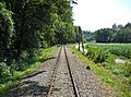
Listed route of the Steyrtalbahn
.JPG)


.JPG)

proof
- ↑ a b Christine Grüll: It's good to live in Unterhimmel. ( Heaven on Earth series - A journey to places with “heavenly references” , part 1 of 5). In: KirchenBlatt No. 31 (2011), August 3, 2011 (online, kath-kirche-vorarlberg.at, accessed September 3, 2018).
-
↑ Friedrich Berndt, Hans Stögmüller: The paper mills from Steyr. In: Yearbook of the Steyr City Archives 2, 2010, pp. 9–44;
Friedrich Berndt: Steyr paper watermarks. In: Publications of the cultural office of the city of Steyr , issue November 1950, pp. 20–28 ( article pdf , eReader , both steyr.dahoam.net). - ↑ The Josephinische Landesaufnahme (around 1780) gives under Himel and Eisenhamer ; in the Franciscan Cadastre (around 1830) Unterhimmel (all country recordings online on Arcanum / Austrian State Archives: mapire.eu ).
- ↑ The lower heaven had two crescent moons (with a star); cf. list of scythe factories in Austria: An der Steyr .
- ↑ Alois Souvent: Administrative map of the Archduchy of Austria ob der Enns , 1st edition 1857 (online at DORIS: Topic first country recordings , Layer Souvent 1857 , there also other maps).
- ^ Hermann Karrer: Revitalization of the wire drawing works in Steyr, Unterhimmel 1/2. Diploma thesis, Vienna University of Technology, 2001.
- ↑ a b [?] Prokop: Unterhimmel - The train station to the Christ Child. In: Motivgruppe Weihnachten eV: Rundbrief 154, July 2016 ( pdf , excerpt from mg-weihnachten.de, accessed September 7, 2018; table of contents circulars ) - to the old train station.
- ↑ Peter Prack: News from Unterer Steyr and Enns. Part II, in: ÖKO · L 39/4 (2017), p. 22 ff ( full article, p. 21–35, pdf , files.wordpress.com, accessed September 7, 2018).

Location: Steyr
Cadastral parishes: Christkindl | Föhrenschacherl | Gleink | Hinterberg | Jägerberg | Sarning | Stone | Steyr
City districts (settlement identification) :
Christkindl •
Ennsleite •
Gleink •
Gründberg •
Hausleiten •
Münichholz •
Place •
Pyrach •
Stein •
Steyr •
Steyrdorf
Rotten:
Damm •
Dornach •
Haidershofen •
Maria im Winkl •
Neustift •
Weinzierl |
Settlement:
horticulturist |
Other locations:
Christkindlsiedlung •
Eisenfeld ( Karolinental ) •
Fischhub •
Gründbergsiedlung •
Neuschönau •
Ramingsteg •
Reichenschwall •
Resthof •
Sarning •
Schlühslmayrsiedlung •
Schlüsselhof •
Steyrwerke •
Tabor •
Unterhimmel •
Waldrandsiedlung •
Wehrgraben
Statistical districts (municipality structure): Innere Stadt | Steyrdorf | Tabor (west) , Stein (south) | Tabor (east) , Resthof | Ennsdorf , Ennsleite , Fischhub | Pyrach , Reichenschwall | Christkindl , Schlühslmayr | Gründbergsiedlung | Stone , gleink | Winkling / Hausleiten | Münichholz / Hinterberg
Statistical zones (municipal structure): Inner City | Steyrdorf | Weir ditch | Old Tabor | Tabor Resthof | Ennsdorf | Fish lift | Forest edge settlement | Ennsleite | Neuschönau | Pyrach / Reichenschwall | Christkindl / Schlühslmayr | Gründbergsiedlung | Steyr-Gleink | Winkling / Hausleiten | Münichholz | Hinterberg / Hammer | Schlüsselhof location | stone
City districts and counting districts (old): I.Bez .: Inner City | II.ez .: Steyrdorf | III.Dec .: Stone | IV.Dec .: Place | V.Bez.:Ennsdorf (with ZBez V.Bez.:Ennsleite ) | VI.Dec .: Pyrach | VII.Dez.:Christkindl | VIII.Bez .: Grundberg | IX.Des .: Gleink | X.Bez .: Hausleiten | XI.Bez .: Munichholz
Former communities: Jägerberg 1851–1857 • Gleink 1851–1938 | Historical locations: Aichet • Aussersteyrdorf • Bei der Steyr • Josefstal • Hammer • Ramingdorf • Schönau ( Kühberg ) • Vogelsang • Wieserfeld