
Münichholz
|
Münichholz ( district ) cadastral community Hinterberg Statistical district Münichholz / Hinterberg |
|||
|---|---|---|---|
|
|||
| Basic data | |||
| Pole. District , state | Steyr (SR), Upper Austria | ||
| Judicial district | Steyr | ||
| Pole. local community | Steyr | ||
| Locality | Steyr | ||
| Coordinates | 48 ° 3 '14 " N , 14 ° 26' 22" E | ||
| height | 305 m above sea level A. | ||
| Residents of the stat. An H. | 6360 (2009) | ||
| Building status | 1350 (approx. Addresses 2018 ) | ||
| Area d. KG | 3.94 km² | ||
| Post Code | 4400 Steyr | ||
| Statistical identification | |||
| Cadastral parish number | 49210 | ||
| Counting district / district | ON (40201 20) | ||
 View from the Dambergwarte in Ortisei |
|||
| Part of Steyr since 1938 (status unclear 1945–58); XI. City district (former name until 1992) formerly two localities. Münichholz and Hinterberg (from 1923) and Kat.Gem. Ramingdorf and Hammer von Behamberg Lower Austria; these today are statistical zones 16. Münichholz and 17. Hinterberg / Hammer ; Zählbezirksname age (up to 2000): XI.Bez.:Münichholz Source: STAT : gazetteer ; BEV : GEONAM ; DORIS ; City of Steyr: statute , statistics |
|||

Münichholz is a district of the city of Steyr in Upper Austria , and corresponds to the cadastral municipality of Hinterberg . The villages formerly in Lower Austria were incorporated into Upper Austria in 1938.
geography
The location is northeast of the city center , on the right (eastern) side of the Enns on the western edge of the city, directly on the Lower Austrian border. It is located downstream of the Ramingbach estuary, on the 290- 310 m above sea level. A. Height.
Münichholz in the true sense of the word is the western settlement and wetland area directly on the Ennsknie, Hinterberg the eastern industrial area on the terrace at the foot of the Wachtberg and Heuberg .
The district with 394.2 hectares includes a little under 1400 addresses with almost 6500 inhabitants.
|
Gleink (KG)
|
Hausleiten (Stt.)
Enns
|
|
|
Rest yard
Steyr (KG)
Enns
Place (stt.) Enns
|
.svg)
|
Heuberg
Wanzenöd (KG)
Wachtberg |
|
Bürstmayr settlement
Kleinraming (KG)
(both in St. Ulrich b. Steyr )
|
history
There was already a farm here in Roman times , perhaps in connection with iron processing. It was found in the 1990s during the emergency excavation in the course of the construction of the Steyrer Nordspange (B122a). Otherwise there is no evidence of an alleged street station in Steyr.
The Minichholz was originally the forest area at the mouth of the Ramingbach near Ramingdorf . This village belonged to Haidershofen , which was the monastery parish of the Gleink monastery until 1784 . This is what the name ('Mönchswald') refers to. 13 houses are documented for 1437. The Ramingdorfer Althof dates back to the 9th century, the Ramingdorf noble residence appears at the turn of the 13th and 14th. Century, the rule was mostly in the hands of Steyr families.
In addition to Münichholz with an area of 1.84 km², the Hinterberg tax community was also formed here around 1830, and now more independent localities. At that time Münichholz had 23 houses with 135 inhabitants, Hinterberg 13 houses with 74 inhabitants, Hammer 7 houses with 25 inhabitants, and Ramingdorf 19 houses with 129 inhabitants. With the creation of the local communities in 1848/49 , both cadastral communities became part of the Unterennsischen political community Behamberg , belonging to the quarter above the Vienna Woods . The two corresponding localities were called Ramingdorf and Hammer , respectively, and the locality names Münichholz and Hinterberg did not appear until the 1920s .
In 1868 the St. Valentin – Steyr line was opened by the kk priv. Kronprinz Rudolf-Bahn (today the Ennstal branch line of the Rudolfsbahn ), which leads here via Hinterberg to the train station in Ennsdorf .
The Österreichische Waffenfabriksgesellschaft zu Ennsdorf (1924 Steyr-Werke AG, 1934 Steyr-Daimler-Puch AG ) began producing ball bearings in Hammer as early as 1922 ; the factory (formerly Steyr Wälzlager ) has been SKF Steyr since 1988. Today's BMW engine plant emerged from the systems for engine construction . In 1956, Steyr-Daimler-Puch also relocated a foundry here (since 1988 SLR-Guss).
A decisive turning point in the history of Münichholz was the invasion of Austria by the National Socialists on March 13, 1938. The district in its current form is closely related to the armament of the Third Reich and the tasks that were intended for the city of Steyr and the Steyr works . These were connected to the Hermann Göring works and converted to the armaments industry.
Münichholz was annexed to the city of Steyr on October 15, 1938 for the purpose of building a large housing estate. At the same time, the two parts of the village Münichholz and Hinterberg - the latter included today's industrial area - became the XI. City district and the village of Münichholz and the cadastral municipality of Hinterberg of the same area are united.
At the time the village had 221 residents, mostly farmers. In the period from September 22, 1938 to August 18, 1939, the residents of 29 properties (farms) were evacuated. The regime set up a National Socialist model settlement , the Münichholz factory settlement , which , when completed, was to offer up to 20,000 people apartments. There was also a satellite camp of the Mauthausen concentration camp with up to 3,090 prisoners on Haagerstraße with the Steyr-Münichholz subcamp . These were used by the Steyr works for construction work and by the municipality of Steyr for building halls and roads and for creating air raid tunnels . There were many attacks, mistreatment and "shootings while trying to escape".
When the construction of Münichholz began in 1938, it was irrelevant to the administration that this area belonged to Lower Austria. The Reichsgaue ( Upper Danube and Lower Danube ) were divided up differently without much ado. After the end of the war, Austrian law as a whole was reset to the state it was in before the Anschluss ( law transition law 1945), but this only related to basic democratic values. Other regulations were put into effect “until the redesign” (§ 2 R-ÜG). This meant that the status of the shifting of the national border, which was also the border of the American and Soviet occupation zones, was unclear. Until August 1945 the city was completely divided on the Steyr, then the border was withdrawn to today's state border, but Münichholz belonged to the Soviet occupation zone.
On July 7, 1948, the Upper Austrian Landtag passed a town statute for Steyr, in which Münichholz is named as part of Steyr. On the Lower Austrian side, however, it was still run as a part of the Behamberger municipality. After the conclusion of the state treaty in 1955, with which the original state borders came into force again, negotiations began on Münichholz, which now belonged to Steyr and Upper Austria according to state law, but to Lower Austria according to federal law. According to the Federal Constitutional Act of December 16, 1958, which came into force retroactively on May 1, 1945, Münichholz came from Lower Austria to Upper Austria and the city of Steyr. The transfer was settled with 25 million schillings (about 2 million euros).
As early as 1945 the place received an emergency church , the history of the parish Christ König goes back to the secret camp mission of the Jesuit Josef Meindl, pastor of St. Michael , from 1941. In 1950 the rectory was built . From 1964 the new parish church including the parish center was built. 1967–1974 the vocational school center was established .
Since the new city statute in 1992, Münichreit is no longer considered an XI. District led.
The Steyrer Nordspange B122a with a new Enns bridge over to Dornach was built until 2001.
Economy, infrastructure, culture

- Main companies
- BMW engines (BMW Group Plant Steyr, approx. 4500 employees)
- SKF ball bearings (approx. 1000 employees)
- SLR casting plant (approx. 250 employees)
- traffic
The main traffic axis is the Steyrer Nordspange B122a of the Voralpen Straße (Amstetten - Steyr).
The Steyr-Münichholz stop is on the Ennstal route of the Rudolfsbahn .
- Attractions
- Old parish church Christ König (Notkirche)
- New Parish Church of Christ the King
- Werksiedlung (listed, ensemble with numerous other similar buildings)
- nature
The district has a high proportion of forest and green areas, with the Münichholz Forest as a closed alluvial forest area. The Ennsknie with the steep conglomerate drop to the river lies in the last free stretch of the Enns in Upper Austria.

Leo-Gabler-Straße with block development

Karl-Punzer-Strasse with the tower of the New Parish Church. Right: Hans-Wagner-Strasse
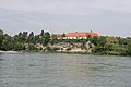
The Ennsknie with the steep conglomerate drop

Forest in Münichholz


literature
- Helmut Retzl: Münichholz - a district through the ages . Steyr 1986 (= publications of the cultural office of the city of Steyr 37; similarly also publication of the educational and cultural working group Münichholz , 1985).
- Helmut Retzl, Günter Rammerstorfer: Steyr-Münichholz - model settlement, broken glass district, future model , Ennsthaler Verlag, 2018, ISBN 978-3-85068-991-5
Web links
Individual evidence
- ↑ a b c § 1 d) concerning the re-enactment of the law with the law of 18 March 1930 LGBl. No. 13/1930, community statute enacted for the city of Steyr pdf. Law Gazette no. 41/1948 20 piece (, ris .bka ; retroactively effective January 1, 1946).
- ↑ a b Announcement of the above State government on the republication of the statute for the city of Steyr LGBl. No. 9/1992 6th issue (as amended online, ris.bka ).
- ↑ a b c For the purpose of internal statistics, the two parts are kept separate: Statistical district: 20 Münichholz / Hinterberg (counting district 20 XI.Bez.:Münichholz of Statistics Austria, which has not been named since the 2000s); Statistical zones 16. Münichholz and 17. Hinterberg / Hammer within the scope of the original cadastral communities; see statistical districts. Statistical Zones. Statistical counting districts. Magistrat Steyr, planning date 2008 (all pdf, accessed July 8, 2018).
- ↑ Eva Kuttner, OÖLM: Münichholz - building remains of a homestead ( memento from July 20, 2014 in the Internet Archive ). In: AIS-OOE (accessed November 14, 2017).
- ↑ a b The Josephinische Landesaufnahme (around 1780) only lists various locations in Ramingdorf , Hamersch [miede] and Hammer M [ühle] (lower and upper of the Enns; on the Raming) and (castle) Ramingdorf (downstream of the Enns); the Franciscan cadastre (around 1830) gives the places Münichholz, Hinterberg, Hamer and Ramingdorf ; In the Franzisco-Josephinische Landesaufnahme around 1880 (1: 25000, after the construction of the Rudolfsbahn) only the forest Münichholz and the place Ramingdorf appear (all regional recordings online on Arcanum / Austrian State Archive: mapire.eu ).
- ↑ a b Peter Wiesinger: Ortnamesbuch des Landes Oberösterreich , Volume 10. Verlag der Österreichische Akademie der Wissenschaften, 2001, ISBN 3-7001-2156-3 , entry 7.9.1.9 Münichholz , p. 213.
- ^ A b Franz [Xavier Joseph] Schweickhardt Ritter von Sickingen: Representation of the Archduchy of Austria under the Ens. 10th volume, 2nd row district of the Upper Vienna Woods. 1838, hammer. P. 104 f; Hinterberg. P. 107; Münichholz. P. 113 f. ( Digitized, Google, full view ).
-
↑ a b Kurt Klein (edit.): Historical local dictionary . Statistical documentation on population and settlement history. Ed .: Vienna Institute of Demography [VID] d. Austrian Academy of Sciences . Upper Austria Part 1, Steyr (City): Districts: 11. - Münichholz; Statistical zones
, p.
14 ( online document , explanations . Suppl . ; both PDF - oD [updated]). Special references: documented (1437): Heinrich Weigl: Historisches Ortnamesbuch von Niederösterreich. 1. Vol., 1964, 113 ff. • 1830: Mostly information from the military conscription 1830/37, some older. According to ops.cit. Schweickhardt 1838. • 1869 and later: Central Statistical Commission / Federal Statistical Office / Austrian Central Statistical Office / Statistics Austria (ed.): Directory of places . (Results of the population censuses, from 2011 register censuses).
- ↑ Provincial Government Gazette 1/1855 on the new territorial division […] of the Archduke of Lower Austria , Supplement No. 2 Alphabetical index of all places in the Crown Land of Lower Austria . List entries Münichholz (R and KG), p. 584; Hinterberg (3rd, R and KG), p. 356; Hammer (R), p. 322; Ramingdorf (R), p. 716 ( digitized version, Google, full view ).
- ^ In the index of places 1923; Information from the Austrian Working Group for Urban History Research , Ludwig Boltzmann Institute for Urban History Research (Hrsg.): Research on the history of cities and markets in Austria. Volume 2, Verlag J. Wimmer, 1989, Behamberg , p. 259; see ops.cit. Small.
- ↑ a b SKF Austria AG; and The History of SKF in Austria: 1988–1990. skf.com, both accessed July 8, 2018.
- ↑ a b BMW Group Plant Steyr bmwgroup-werke.com.
- ↑ a b Chronicle. SLR-Gusswerk (slr.at), accessed July 8, 2018.
- ↑ DORIS, topic historical municipal boundaries
- ↑ a b See area development of the city of Steyr. Magistrat Steyr, planning date 2008 (pdf, accessed July 8, 2018).
- ^ Roman Sandgruber: The world economic crisis in Upper Austria in the forum OoeGeschichte.at
- ↑ Josef Fuchshuber: From the history and the new time of Behamberg . In: Local history supplements to the official gazette of the district administration Amstetten 13, 142, 1984, pp. 1-4. ( Article online , on heimatforschung-noe.blogspot.co.at, 2012).
- ↑ The establishment of the district court. Hilda Lessner, Gerhard Obermayr: Haus-Chroniken von Haag (chronik.stadthaag.com), accessed July 9, 2018.
- ↑ Parish Steyr-Münichholz; and history of the parish. Parish Steyr-Münichholz, on dioezese-linz.at.
- ↑ SKF rolling bearings from Steyr in Formula 1. In: Oberösterreichische Nachrichten online (nachrichten.at), April 7, 2015.
- ↑ Peter Prack: The Ennsknie in Steyr, a - unfortunately not explained - natural monument. In: OEKO 2008/1, pp. 6–21 ( PDF on ZOBODAT ).

Location: Steyr
Cadastral parishes: Christkindl | Föhrenschacherl | Gleink | Hinterberg | Jägerberg | Sarning | Stone | Steyr
City districts (settlement identification) :
Christkindl •
Ennsleite •
Gleink •
Gründberg •
Hausleiten •
Münichholz •
Place •
Pyrach •
Stein •
Steyr •
Steyrdorf
Rotten:
Damm •
Dornach •
Haidershofen •
Maria im Winkl •
Neustift •
Weinzierl |
Settlement:
horticulturist |
Other locations:
Christkindlsiedlung •
Eisenfeld ( Karolinental ) •
Fischhub •
Gründbergsiedlung •
Neuschönau •
Ramingsteg •
Reichenschwall •
Resthof •
Sarning •
Schlühslmayrsiedlung •
Schlüsselhof •
Steyrwerke •
Tabor •
Unterhimmel •
Waldrandsiedlung •
Wehrgraben
Statistical districts (municipality structure): Innere Stadt | Steyrdorf | Tabor (west) , Stein (south) | Tabor (east) , Resthof | Ennsdorf , Ennsleite , Fischhub | Pyrach , Reichenschwall | Christkindl , Schlühslmayr | Gründbergsiedlung | Stone , gleink | Winkling / Hausleiten | Münichholz / Hinterberg
Statistical zones (municipal structure): Inner City | Steyrdorf | Weir ditch | Old Tabor | Tabor Resthof | Ennsdorf | Fish lift | Forest edge settlement | Ennsleite | Neuschönau | Pyrach / Reichenschwall | Christkindl / Schlühslmayr | Gründbergsiedlung | Steyr-Gleink | Winkling / Hausleiten | Münichholz | Hinterberg / Hammer | Schlüsselhof location | stone
City districts and counting districts (old): I.Bez .: Inner City | II.ez .: Steyrdorf | III.Dec .: Stone | IV.Dec .: Place | V.Bez.:Ennsdorf (with ZBez V.Bez.:Ennsleite ) | VI.Dec .: Pyrach | VII.Dez.:Christkindl | VIII.Bez .: Grundberg | IX.Des .: Gleink | X.Bez .: Hausleiten | XI.Bez .: Munichholz
Former communities: Jägerberg 1851–1857 • Gleink 1851–1938 | Historical locations: Aichet • Aussersteyrdorf • Bei der Steyr • Josefstal • Hammer • Ramingdorf • Schönau ( Kühberg ) • Vogelsang • Wieserfeld

Cadastral communities and localities: Badhof | Penz | Ramingdorf | Bedbugs
Villages: Behamberg • Holz • Oedt • Ramingdorf | Rotten: Anger • Badhof • Blindhof • Brettbach • Kindlehen • Penz • Post • Pühring • Raming • Schaumberg • Steinbach • Wanzenöd • Weixelgarten | Scattered houses: Anetzberg • Daxberg • Eglschachen • Heuberg • Knarzhub • Laach • Ritz • Wachtberg
Counting district: Ramingdorf | Bedbugs | Badhof - Penz
Former parts of the village: Hinterberg (KG, until 1938/58) • Münichholz (KG, until 1938/58) | Historical locations: Hammer