
Ortisei near Steyr
|
Ortisei near Steyr
|
||
|---|---|---|
| coat of arms | Austria map | |
 |
|
|
| Basic data | ||
| Country: | Austria | |
| State : | Upper Austria | |
| Political District : | Steyr-Land | |
| License plate : | SE | |
| Main town : | Ortisei near Steyr | |
| Surface: | 39.1 km² | |
| Coordinates : | 48 ° 1 ' N , 14 ° 25' E | |
| Height : | 377 m above sea level A. | |
| Residents : | 3,043 (January 1, 2020) | |
| Population density : | 78 inhabitants per km² | |
| Postal code : | 4400 | |
| Area code : | 07252 | |
| Community code : | 4 15 14 | |
| NUTS region | AT314 | |
| Address of the municipal administration: |
Pfarrplatz 7 4400 Ortisei near Steyr |
|
| Website: | ||
| politics | ||
| Mayoress : | Annemarie Wolfsjäger ( ÖVP ) | |
|
Municipal Council : (2015) (25 members) |
||
| Location of St. Ulrich bei Steyr in the Steyr-Land district | ||
  |
||
 Ortisei near Steyr seen from Garsten |
||
| Source: Municipal data from Statistics Austria | ||

St. Ulrich bei Steyr (Sankt Ulrich bei Steyr) is a municipality with 3,043 inhabitants (as of January 1, 2020) in Upper Austria in the Steyr-Land district .
geography

St. Ulrich bei Steyr is located in the Steyr-Land district in Upper Austria's Traunviertel , directly to the southeast bordering the city of Steyr . The municipality extends left bank of the Ramingbach to the south, the creek is over long stretches of the state border with Lower Austria
The extension is 11.4 km from north to south and 10.1 km from west to east. 50.5% of the area is forested, 40.3% is used for agriculture.
In the south lies the massif of the Spadenberg ( 1000 m above sea level , the summit of which is the highest point in the municipality), its northern side ridge Schwarzberg ( 838 m above sea level ) - Damberg ( 807 m above sea level ) forms the further southern one Municipal boundary. These edge-alpine mountains are included in the Upper Austrian Pre-Alps and the Enns and Steyrtal Flysch Mountains .
Community structure
The municipality includes the following six localities (population in brackets as of January 1, 2020):
- Sankt Ulrich bei Steyr - main town on the Enns near Steyr (1447)
- Gmain - northeast of Ortisei at the lowest Ramingbach (31)
- Unterwald - southeast of St. Ulrich am Damberg (758)
- Kleinraming - in the southeast in the Ramingtal (570)
- Kohlergraben - behind Kleinraming on Spadenberg (108)
- Ebersegg - in the south-east on Spadenberg (129)
The community consists of the cadastral communities of St. Ulrich (Sankt Ulrich, Gmain), Unterwald and Kleinraming (Kleinraming, Kohlergraben, Ebersegg).
Counting areas are Ortisei near Steyr-Nord for Ortisei, Gmain, Unterwald and Ortisei near Steyr-Süd for Kleinraming, Kohlergraben, Ebersegg
Neighboring communities
|
Steyr (Sdt.)
|
Behamberg ( District Amstetten , Lower Austria ) | |
| Cooked |
.svg)
|
St. Peter in der Au ( District Amstetten , Lower Austria ) |
| Laussa Großraming | Maria Neustift |
history
Originally located in the eastern part of the Duchy of Bavaria , the place belonged to the Duchy of Austria since the 12th century . Since 1490 it has been assigned to the Principality of Austria ob der Enns .
During the Napoleonic Wars , the place was occupied several times.
With the creation of the local communities in 1848/49 , Jägerberg , Unterwald and Kleinraming became independent local communities. In 1857 the three were united, the new community was named St. Ulrich . The addition at Steyr has been around since 1912.
Since 1918 the place belongs to the federal state of Upper Austria. On April 1, 1935, the villages of Jägerberg, Neuschönau and Ramingsteg came to Steyr (the new cadastral community of St. Ulrich was formed from the remaining parts of Jägerberg ).
After the connection of Austria to the German Reich on March 13, 1938 St. Ulrich part of the district Steyr , and belonged to the Upper Danube . In 1942 the community became independent again. After 1945 the restoration of Upper Austria took place.
Population development

From 1981 to 2011, the slightly negative balance of migration was offset by a more positive birth balance.
politics
The responsible judicial district is Steyr .
Community representation
Distribution of seats since the municipal council election 2015 :
- 16 mandates of the Austrian People's Party (ÖVP)
- 5 mandates of the Social Democratic Party of Austria (SPÖ)
- 4 mandates for the Freedom Party of Austria (FPÖ)
Mayor is Annemarie Wolfsjäger from the ÖVP.
- mayor
- 1969–1989: Thaddäus Steinmayr (ÖVP)
- Annemarie Wolfsjäger (ÖVP)
coat of arms
|
|
Blazon : "In blue a golden , upright bishop's staff , covered by a silver, downwardly curved huchen ."
The municipality colors are blue-white-blue. |
|
Justification of the coat of arms: fish and bishop's staff speak as attributes for the St. from 923 to 973 as bishop of Augsburg . Ulrich , who gave the place its name as the parish patron. The Huchen , however, also points to the former large fish ark in Freising , just as the crook can characterize the founding of the parish by the Garsten Monastery .
Awarded: February 22, 1971 |
Community partnerships
St. Ulrich bei Steyr has had a partnership with the Bavarian Postbauer-Heng since 1978 .
Capital of the municipality
|
St. Ulrich ( rotting ) village of Sankt Ulrich bei Steyr ( capital of the municipality ) Cadastral Ortisei |
|
|---|---|
| Basic data | |
| Pole. District , state | Steyr-Land (SE), Upper Austria |
| Judicial district | Steyr |
| Pole. local community | Ortisei near Steyr |
| Coordinates | 48 ° 1 ′ 18 " N , 14 ° 25 ′ 22" E |
| height | 377 m above sea level A. |
| Residents of the village | 1447 (January 1, 2020) |
| Area d. KG | 4.93 km² |
| Post Code | 4400 Steyr |
| Statistical identification | |
| Locality code | 11967 |
| Cadastral parish number | 49234 |
| Counting district / district | Ortisei near Steyr-Nord (41 514 000) |
| Village with Thaddlau and Erdsegen , cadastral parish also with Gmain Source: STAT : Ortverzeichnis ; BEV : GEONAM ; DORIS |
|
The main town of the municipality is Sankt Ulrich bei Steyr , also a locality and cadastral municipality of the municipality.
Sankt Ulrich is located directly south of the city of Steyr , on the southern western edge of the municipality. The Rotte is approximately elevated on the right bank of the Enns . The town center with the Ulrichskirche rises on a hill between Rahofergraben and Freisingbach to around 380 m above sea level. A. Height. The Damberg ( 807 m above sea level ) rises to the southeast . On the Enns, Sankt Ulrich has already completely grown into the city of Steyr.
The village of Sankt Ulrich bei Steyr also includes the Thaddlau , a settlement on the city limits directly above Ennsleite , and the village of Erdsegen . The village has roughly 400 addresses with around 1400 inhabitants (January 1, 2020: 1447), half of the community's population.
The village of Gmain to the northeast also belongs to the cadastral municipality of Ortisei with 492.7 hectares .
|
Steyr (O and hours)
Ennsleite
(Stt., Std. Steyr) |
Jägerberg (KG, Steyr)
|
Kleinraming (KG) ∗
Gmain (O) |
| Enns |
|
|
- ∗ The place Kleinraming is southeast behind Unterwald.
- ∗∗ The place Unterwald lies to the east, the cadastral community extends south.
Up until the beginning of the 20th century, St. Ulrich was a small parish , just the church and a larger farm. The village had only 30 houses with 250 inhabitants in the interwar period. The development of the area only started in the pre-war years through the expansion of the Steyr works .
The cadastral community was formed in 1935 from those parts of Jägerberg that did not come to the city of Steyr.
Economy and Infrastructure
traffic
The traffic axis of the community is the Kleinramingstraße ( L559 ), which leads from Steyr- Münichholz ( B122a ) through the Ramingtal to Maria Neustift to the Großramingstraße (L557). The latter connects the Ennstal near Großraming with the Ybbstal near Waidhofen.
Public facilities
In the municipality of Ortisei there are three fire brigades (volunteer fire brigade St. Ulrich, volunteer fire brigade Kleinraming, volunteer fire brigade Ebersegg), which are geographically optimally divided to protect the population.
Culture and sights
- Parish Church of St. Ulrich
- Parish Church of the Immaculate Conception in Kleinraming
- On the Damberg , which partly belongs to Ortisei, are the Windloch , a natural cave, the 36 m high Dambergwarte and the Laurenzikapelle, built in 1864 .

The Damberg
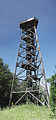
The Dambergwarte

The Laurence Chapel


Sports and clubs
- Football club USV Ortisei: founded on June 6, 1964, the venue is the Voralpenstadion
- Tennis club USV Ortisei
- Photo club Ortisei
Personalities
Sons and daughters of the church
- Josef Ahrer (1908–1934), social democrat
- Hermine Kubanek (1917-2001), politician (SPÖ)
Personalities associated with the community
- Thaddäus Steinmayr (1921-2017), politician (ÖVP)
Web links
- Website of the municipality (st-ulrich-steyr.ooe.gv.at)
- 41514 - Ortisei near Steyr. Community data, Statistics Austria .
- Further information about the municipality of St. Ulrich bei Steyr can be found on the geographic information system of the federal state of Upper Austria .
- Map in the Digital Upper Austrian Room Information System ( DORIS )
Individual evidence
- ↑ Statistics Austria: Population on January 1st, 2020 by locality (area status on January 1st, 2020) , ( CSV )
- ↑ a b c d Ortisei b.St. History: Mayor (land-oberoesterreich.gv.at) - there St. Ulrich, Unterwald, Kleinraming; Jägerberg is managed by Steyr ibid.
- ^ A b c Wilhelm Rausch, Hermann Rafetseder: Area and name changes of the municipalities in Austria since the middle of the 19th century. Volume 2 of the Austrian Working Group for Urban History Research , Ludwig Boltzmann Institute for Urban History Research : Research on the history of cities and markets in Austria. Landesverlag, Linz 1989, ISBN 3-9003-8722-2 , p. 261 ( limited preview in the Google book search).
- ↑ a b Announcement of the Governor of Upper Austria of April 8, 1935 regarding changes to the municipal boundaries between the municipalities of Steyr and St. Ulrich. LGBl. No. 22/1935, p. 56 (EReader, ALEX Online ).
- ^ A b c Manfred Brandl: New history of Steyr. From Biedermeier to today. Verlag Wilhelm Ennsthaler, Steyr 1980, ISBN 3-85068-093-2 , p. 159 f ( limited preview in the Google book search).
- ↑ Statistics Austria, A look at the community of St. Ulrich bei Steyr, population development. Retrieved March 23, 2019 .
- ↑ Former place of jurisdiction of the castle rule Steyr; for the rake see Joseph Löw: The episcopal fish ark next Garsten ad Enns. Lithograph, 1823 ( fig. Online . Steyrerpioniere.wordpress.com, accessed July 13, 2018).
- ↑ As in the Franzisco-Josephinische Landesaufnahme around 1880 (layer online at DORIS, various map themes, e.g. first regional recordings ).
-
↑ a b Kurt Klein (edit.): Historical local dictionary . Statistical documentation on population and settlement history. Ed .: Vienna Institute of Demography [VID] d. Austrian Academy of Sciences . Upper Austria part 2, St. Ulrich bei Steyr: St. Ulrich bei Steyr
, p.
79 ( online document , explanations . Suppl . ; both PDF - oD [updated]). Special sources: 1869 and later: Central Statistical Commission / Federal Statistical Office / Austrian Central Statistical Office / Statistics Austria (ed.): Directory of places . (Results of the population censuses, from 2011 register censuses).
- ↑ Damberg circular hiking trail with the Bible trail . nationalparkregion.com, accessed on July 15, 2014.

Adlwang | Aschach an der Steyr | Bad Hall | Dietach | Gaflenz | Garsten | Großraming | Laussa | Losenstein | Maria Neustift | Parish churches near Bad Hall | Rich raming | Rohr im Kremstal | Schiedlberg | Sierning | Ortisei near Steyr | Ternberg | Waldneukirchen | Weyer | Wolfern
Cadastral communities: Kleinraming | Ortisei | Unterwald
Locations: Ebersegg | Gmain | Kleinraming | Kohlergraben | Sankt Ulrich bei Steyr | Unterwald
Hamlet: Wohlfahrtsberg | Rotten: Kleinraming • Sankt Ulrich bei Steyr • Thaddlau | Settlement: Bürstmayrsiedlung | Scattered houses: Unterwald • Ebersegg • Gmain • Großkohlergraben • Kleinkohlergraben | Other locations: Am Damberg • Erdsegen • Gerold Chapel • Laurenzikapelle
Counting district: Ortisei near Steyr-Nord | Ortisei near Steyr-Süd
Former communities: Jägerberg 1851–1857 (OB –1935) • Kleinraming 1851–1857 • Unterwald 1851–1857 | Former parts of the village: Neuschönau • Ramingsteg