
Damberg (Upper Austria)
| Damberg | ||
|---|---|---|
 View from Ortisei |
||
| height | 807 m above sea level A. | |
| location | Upper Austria , Austria | |
| Mountains | Enns and Steyrtaler Flysch Mountains , Upper Austrian Pre-Alps | |
| Dominance | 2.7 km → Schwarzberg | |
| Notch height | 141 m ↓ Hertlerwiese | |
| Coordinates | 48 ° 0 '13 " N , 14 ° 27' 27" E | |
|
||

The Damberg is 807 m above sea level. A. high mountain in the Upper Austrian Alps . It is located in the communities of St. Ulrich bei Steyr and Garsten . It is Steyr's local mountain . On the mountain are the Dambergwarte , the Laurenzikapelle built in 1864 at the Gasthof Schoiber and the Windloch, a natural cave at 747 m above sea level.
From Damberg the view extends to the Mostviertel , Mühlviertel , Florianer Landl as well as the Enns and Steyrtal in the Kalkalpen National Park .
Hiking trails lead from Steyr and Garsten to the Damberg, and it is also on the Linz Mariazeller Weg .
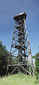
Dambergwarte

Laurenzikapelle

Gasthof Schoiber with Steyr in the background


Individual evidence
- ↑ Damberg circular hiking trail with the Bible trail accessed on October 27, 2017 (Dambergwarte, Laurenzikapelle, Windloch)
Web links
Commons : Damberg - collection of images, videos and audio files
- Damberg , bergfex.at