Dietach
|
Dietach
|
||
|---|---|---|
| coat of arms | Austria map | |
|
|
||
| Basic data | ||
| Country: | Austria | |
| State : | Upper Austria | |
| Political District : | Steyr-Land | |
| License plate : | SE | |
| Surface: | 20.7 km² | |
| Coordinates : | 48 ° 6 ' N , 14 ° 25' E | |
| Height : | 313 m above sea level A. | |
| Residents : | 3,270 (January 1, 2020) | |
| Population density : | 158 inhabitants per km² | |
| Postal code : | 4407 | |
| Area code : | 07252 | |
| Community code : | 4 15 04 | |
| NUTS region | AT314 | |
| UN / LOCODE | AT DIA | |
| Address of the municipal administration: |
Kirchenplatz 6 4407 Dietach |
|
| Website: | ||
| politics | ||
| Mayor : | Johannes Kampenhuber ( ÖVP ) | |
|
Municipal Council : (2015) (25 members) |
||
| Location of Dietach in the Steyr-Land district | ||
| Source: Municipal data from Statistics Austria | ||
Dietach is a municipality with 3270 inhabitants (as of January 1, 2020) in Upper Austria in the Steyr-Land district in the Traunviertel . The responsible judicial district is Steyr .
geography
The extension is 6.6 km from north to south and 6.4 km from west to east. 17.1% of the area of the municipality is forested, 72.2% is used for agriculture.
Neighboring communities
|
Hargelsberg ( district Linz-Land ) |
Kronstorf ( district Linz-Land ) |
|
| Wolfern |

|
Haidershofen ( District Amstetten , Lower Austria ) |
|
Steyr (statutory city) |
Community structure
The municipality includes the following five localities (population in brackets as of January 1, 2020):
- Dietach - main town, with the southwest (1421)
- Dietachdorf - in the south (1301)
- Stadlkirchen - northeast of the main town (262)
- Thann - in the northeast (170)
- Winkling - in the east on the Enns (116, parts also in Kronstorf and the city of Steyr )
The municipal administration gives Heuberg (near Dietach) and Niedergleink (in the south near Steyr) as further localities (in the sense of a community-owned structure ).
The community consists of the cadastral communities Mitterdietach (south-west), Oberdietach (north-west) and Unterdietach (east).
Counting districts are Dietach-Südwest (Dietach, Dietachdorf) and Dietach-Nord-und Ost (rest of the municipality).
history
The place was first mentioned in 777 as Todicha in the letter of the Bavarian Duke Tassilo III. for the foundation of the Kremsmünster Abbey . The word is composed of a Germanic personal name Todo and Old High German aha for river. This resulted in Twedick (1088), Dudich (1170) and finally today's Dietach.
Originally located in the eastern part of the Duchy of Bavaria , the place belonged to the Duchy of Austria since the 12th century . Since 1490 it has been part of the principality, then crown land Austria ob der Enns .
During the Napoleonic Wars , the place was occupied several times.
Since 1918 the place belongs to the federal state of Upper Austria. After the annexation of Austria to the German Reich on March 13, 1938, the place belonged to the Gau Oberdonau . After 1945 the restoration of Upper Austria took place.
Until the Nazi era, Dietach belonged to the Gleink community . In 1938 this had to cede its southern parts, including the main town, to the city of Steyr, so that it only comprised the three original tax communities of Unter-, Mitter-, and Oberdietach, and was subsequently incorporated into the community of Wolfern . On January 1, 1946, Dietach became a separate political municipality under this name.
Population development
In 1991 the community had 2,113 inhabitants according to the census, in 2001 it had 2,436 inhabitants.
politics
The municipal council has 25 members. With the municipal council and mayoral elections in Upper Austria in 2015 , the municipal council has the following distribution:
- 15 mandates of the Austrian People's Party (ÖVP)
- 5 Mandate The Greens - The Green Alternative (GREEN)
- 3 mandates for the Social Democratic Party of Austria (SPÖ)
- 2 mandates for the Freedom Party of Austria (FPÖ)
- mayor
- until 2008 Karl Schweinschwaller (ÖVP)
- since 2008 Johannes Kampenhuber (ÖVP)
coat of arms
|
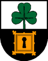
Blazon : “ Divided ; at the top in silver on a stem a green shamrock growing from the dividing line; below in black a golden, square lock leaf decorated with leaf tendrils at the corners. "
The community colors are green-white-red. |
|
Economy and Infrastructure
traffic
- Street: Dietach is located on Steyrer Straße B309, which leads from Steyr to Enns . The West Autobahn A1 is around 15 kilometers from Dietach.
- Bus and train: The Steyr- Linz bus stops regularly in the Dietachdorf district . The Steyr- Hargelsberg buses stop a little less frequently in Dietach itself . The next larger train station is around 7 kilometers from the center of Dietach in Steyr, from where trains run on the Rudolfsbahn to Linz (via Sankt Valentin , with a connection to the Westbahn ) and Kleinreifling .
- Bike path: The Enns bike path R7 runs through Dietach . This leads from the Gasthofalm near Flachau to Enns , where there is a connection to the Danube Cycle Path .
- Cycle path: Überdrüber Landpartie: Upper Austrian cycle path between the communities of Sierning, Wolfern, Dietach, St. Marien and Schiedlberg
leisure
The Niedergleink district of Dietach is one of the six locations of the Star Movie ( Star Movie Steyr ) cinema . The cinema has six halls that are state-of-the-art.
Culture and sights
- Dietach parish church
- Gallhuberhof Farm Technology Museum : in the Thann district
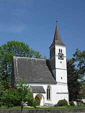
- Filialkirche Stadlkirchen : with important medieval frescoes, in the district of Stadlkirchen
Sports
For sporting activities u. a. the football club Union Procon Wohnbau Dietach (Landesliga Ost), since August 2007 ASKÖ Honda Dietach and “Union Dietach, table tennis section” have formed the game community “Spg Honda Dietach”, as well as the Dietach tennis club.
Web links
- Map in the Digital Upper Austrian Room Information System ( DORIS )
- Further information about the municipality of Dietach can be found on the geographic information system of the federal state of Upper Austria .
Individual evidence
- ↑ Statistics Austria: Population on January 1st, 2020 by locality (area status on January 1st, 2020) , ( CSV )
- ↑ Worth knowing: facts and figures. Dietach community, dietach.at
- ^ Franz Kurz: Contributions to the history of Austria above the Enns . tape 4 . Haslinger, Linz 1809, p. 494 ( digitized, Google, full view ).
- ^ Ordinance of the Provincial Governor of Upper Austria of September 30, 1938 on the unification of areas of the local communities Garsten, Gleink and Sierning with the township of Steyr. VOBl. No. 61/1938 14th piece, p. 44 f (entered into force October 15 of this year according to § 7 and § 2 63/1938; EReader, ALEX Online ).
- ^ A b Wilhelm Rausch, Hermann Rafetseder: Area and name changes of the municipalities in Austria since the middle of the 19th century. (= Research on the history of cities and markets in Austria. Volume 2). 1989, ISBN 3-900387-22-2 , p. 261 ( limited preview in Google book search).
- ^ Announcement by the governor of the Upper Danube Gau on September 28, 1938, regarding the unification of the communities Wolfern and Gleink, consisting of the tax communities: Mitter-, Ober- and Unterdietach to form a community called Wolfern. VOBl. No. 51/1938 10th issue, p. 35 f (entered into force January 1, 1939; EReader, ALEX Online).
- ↑ Small parts of KG Gleink were returned to Dietach on January 1, 1950. ops.cit. Rausch, Rafetseder 1989, ibid.
- ↑ Municipal elections 2015 - result of the Steyr-Land district. ( Memento from September 29, 2015 in the Internet Archive )
- ↑ Star Movie Steyr


