
Klaus power plant
| Klaus power plant | ||
|---|---|---|
 |
||
| location | ||
|
||
| Coordinates | 47 ° 49 '43 " N , 14 ° 9' 27" E | |
| country |
Austria Upper Austria |
|
| place | Klaus at the Pyhrnbahn | |
| Waters | Steyr | |
| Kilometers of water | km 40.1 | |
| power plant | ||
| owner | Ennskraftwerke AG | |
| operator | Ennskraftwerke AG | |
| Start of operation | 1975 | |
| technology | ||
| Turbines | 2 | |
| Others | ||

The Klaus power plant has been a run-of- river power plant on the Steyr River in the Upper Austrian municipality of Klaus an der Pyhrnbahn, which has existed since 1975 . It is located at river kilometer 40.1.
history
A former small power station of the Nettingsdorfer paper mill was 400 meters upstream from the current location. The current run-of-river power plant was built from 1973 to 1975 as the first stage of a planned "Molln pump storage group". This would have included a large storage facility in the Krummen Steyrling valley . The first plans date from the interwar period and were further developed until the 1960s. However, the overall project ultimately failed due to protests from the population. Work in the storage space began in April 1973, and in the same year the bottom drainage tunnel and the drive tunnel were also installed. The Steyr River was diverted through these two tunnels in the following year. The dam was built from mid-February 1974 to April 20, 1975; the damming began on April 24 and was completed on June 27.
Reservoir, dam and power house
The power plant consists of a 55 m high dam and a power house on the right bank of the river. The inlet structures of the 310 m long bottom outlet and the 121 m long drive tunnel are located on the right side of the lake (called Klauser See). The water reaches the turbines through the drive tunnel, the bottom outlet tunnel is used to lower the water level, for example during floods, or to empty the reservoir if necessary. The vault dam is 55 m high, 210 m long and 2 m wide at the crown. Their fundamental strength is on average 10 m. At the top in the middle are five 9 m wide and 5 m high overflow fields , which serve to relieve flooding. The crown carries a public street on consoles. The reservoir is 7.1 km long and 40 m deep. The main tributaries are the Steyr, Steyrling and Teichl . It is located in the deepest section of the gorge. The power house is located on the right bank of the river below the dam before the structure of the bottom outlet. Two Kaplan turbines are used to generate electricity . The output is 20 MW, the annual production 74,000 MWh.

View from the top of the dam on the reservoir

The dam and the structure of the bottom outlet outlet
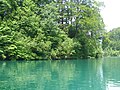
The reservoir of the Klaus power plant

The raid fields with Klaus Castle in the background

The raid fields during the 2013 flood


.jpg)

Leisure time, environment and ecological impact

The reservoir is now a recreational area: the Elisabeth bathing lake is located at the mouth of the Teichl, and the 18 km long Fischersteig runs around Lake Klaus. With the exception of a safety zone in front of the dam, the reservoir can be accessed by boats. A climbing wall and a platform for bungee jumps are attached to the dam. The Pyhrnpass Straße runs along the left bank and Klaus Castle is located on a ledge at the foot of the Brennet mountain . A side effect of the lock is that no more seeds and fruits of alpine plants get into the river below. For this reason, the occurrence of alpine floods near the Rinnenden Mauer in Molln is classified as endangered.
Fish fauna
In the Klaus reservoir, which is characterized by a high oxygen content and excellent water quality, the brown trout is the main fish species and can grow into large specimens here. There are also other salmonid species such as rainbow trout , lake trout , brook char , char and grayling . The predatory fish species, which also include the pike in isolated cases , feed primarily on forage fish such as Mühlkoppen and minnows , which occur in large numbers in the summer months. Due to the unique natural panorama and the high fish productivity, the Klaus reservoir is a strong attraction for trout fishermen worldwide. Among other things, the international trout fishing takes place in this water every year. The Fürstlich Schaumburg-Lippische Forstverwaltung is responsible for exercising fishing rights and issuing fishing permits.
Metal pipe plastic
A large metal pipe sculpture by Pascal Schöning (London) has stood on the inlet structure of the headrace tunnel since 1997 with the title The Attachment of Heaven to Earth . The sculpture bears a Beckett quote on its “wings” : Without here and there where never will come near or go away from anything all the steps of the earth… (German: Raum ohne hier ohne da where nothing ever approaches or removes from something ... )

The metal pipe sculpture

Information board on the dam crest


Web links
Individual evidence
- ↑ a b c d e Verbund.com: Klaus Laufkraftwerk accessed on November 11, 2014
- ↑ Ennskraftwerke AG , accessed on October 1, 2015
- ↑ a b Willibald Girkinger / Wolfgang Heizmann: The Steyr. Landscape and people on the river. Landesverlag 1990, ISBN 3-85214-527-9 , p. 141
- ↑ Austrian map 1: 50,000 (ÖK 50) ( online , accessed on November 11, 2014)
- ↑ kalkalpenweg.at: Klauser Stausee - Freizeitzentrum accessed on November 11, 2014
- ↑ land-oberoesterreich.gv.at: Steyrschlucht - Rinnende Mauer p. 22 (accessed on November 11, 2014)
- ↑ Trout fishing at the Klaus reservoir
- ↑ 7.28 kg heavy and 82 cm long Salvelinus umbla , caught in 2015
- ↑ http://www.fv-schaumburg-lippe.at/de/Fischerei/ Fischen am Stausee Klaus
- ^ Guiding the Klaus reservoir
- ↑ International trout fishing at the Klaus reservoir